All Activity
- Past hour
-

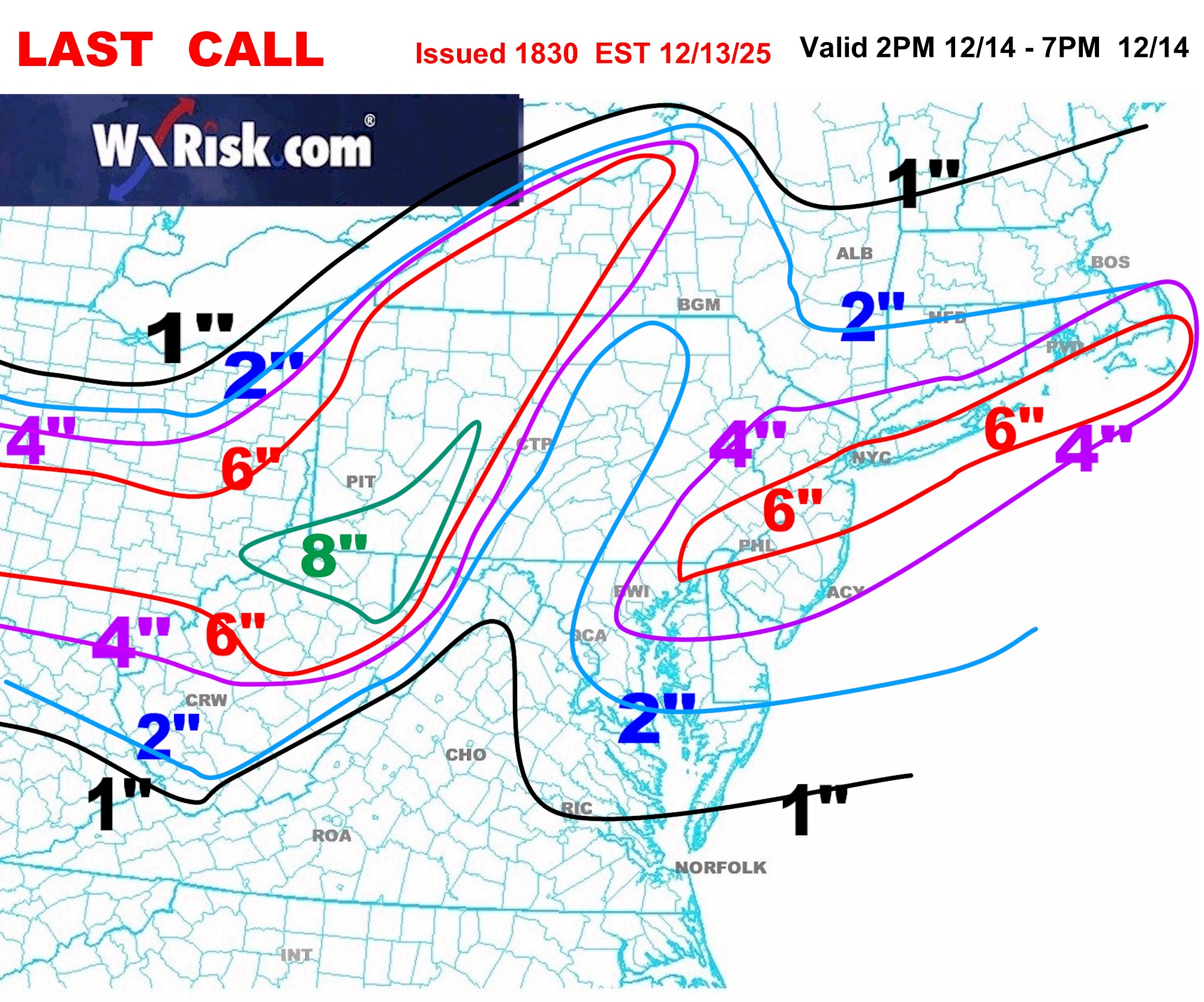
Saturday night/Sunday 12/13-12/14 Jawn
CoolHandMike replied to Ralph Wiggum's topic in Philadelphia Region
Ok so it's snowing here already... Temp still 34°F, not sticking, but really pretty in the street lights. -
If it's a reload period with a definitive end period, that's fine. We all get worried when things just go zonal for weeks on end.
-
Decent rates have finally made their appearance.
-

Digital Snow/Ice Thread 2025-2026
WinstonSalemArlington replied to WinstonSalemArlington's topic in Southeastern States
-
In Union Bridge already? That's great honestly. Very happy to see things going right to frozen once precip starts.
-

Moderate snowfall 12/14/2025 WWA up for most of the area
snywx replied to WeatherGeek2025's topic in New York City Metro
29 w/ moderate snow solid coating on all surfaces expecting an over performer here -
That's a crazy gradient between Hagerstown at .9 and the Catoctins at over 5+. About a 15 mile treck between the 2
-
The post snowfall downer after the tracking upper is a thing. I find going on a hike, taking pics, or something can shift the mindset.
-

December 14th - Snow showers or Plowable snow?
Ginx snewx replied to Sey-Mour Snow's topic in New England
"Welcome to the jungle,we all know why your here" Here's to a good luck first post. -
 Yes. I am a sissy when it comes to going out on ice. I like 6". Preferably 8" of clear non slush ice. The young bucks were out there today. And drilled over the whole lake. 5" of solid clear ice.
 -

Moderate snowfall 12/14/2025 WWA up for most of the area
psv88 replied to WeatherGeek2025's topic in New York City Metro
The frozen ground definitely made a big difference. Down to 33 here and the patio and some of the sidewalks are snow covered. So we won’t lose any qpf later. -

Pittsburgh/Western PA WINTER ‘25/‘26
colonel717 replied to Burghblizz's topic in Upstate New York/Pennsylvania
Looks to be some nice bands setting up just north of the county. -
Just got back from a holiday get together in Manayunk, could have sworn I saw a flake in Blue Bell. 34F/DP 28F
-

Central PA Winter 25/26 Discussion and Obs
MAG5035 replied to MAG5035's topic in Upstate New York/Pennsylvania
Passing an inch here with steady light to moderate. Roads covered and 29ºF. Next couple hours are going to make or break the event here I think in terms of whether I can score a solid advisory event. Some of the better enhanced banding over Pittsburgh should translate over this way in that timeframe. Downsloping hasn’t been too much of an issue so far here being right against the Allegheny Front. Should also note starting to see the enhancement of the precip in the Sus Valley as well on CTP and LWX radar. -
And the Euro AI showed it first I believe. You sent me the snow map, though it was an even more impressive storm initially on the AI.
-
December 14th - Snow showers or Plowable snow?
Ginx snewx replied to Sey-Mour Snow's topic in New England
PFFT? -
Lol man I hate you
-
Raises hand...
-
Saturday night/Sunday 12/13-12/14 Jawn
Physicsteve replied to Ralph Wiggum's topic in Philadelphia Region
Yes i think the precip should start to blossom as this zips across the mountains and the coastal-y enhancement gets going. Hoping it stays later into the morning but could see the dreaded back edge approaching by dawn, so the earlier the start the better to reach those upper bounds. -
From the 00z hrrr, that area I posted above is one of the max spots, and then towards coastal NJ which will have some coastal influence. Maybe 8 is too generous, but I think someone in those areas will see 6+ for sure. Good storm for many though. .
-
Flip to snow has happened 33.8F
-
Pittsburgh/Western PA WINTER ‘25/‘26
colonel717 replied to Burghblizz's topic in Upstate New York/Pennsylvania
Yea turned out that way. At 5 now. Hope I can pick up another inch. 5.3 today puts me at 10 for the year. Wait to see how tomorrow sets up for LE. -
Central PA Winter 25/26 Discussion and Obs
Birdbean replied to MAG5035's topic in Upstate New York/Pennsylvania
To bad it won’t be snowing during the game tomorrow, would be fun to watch!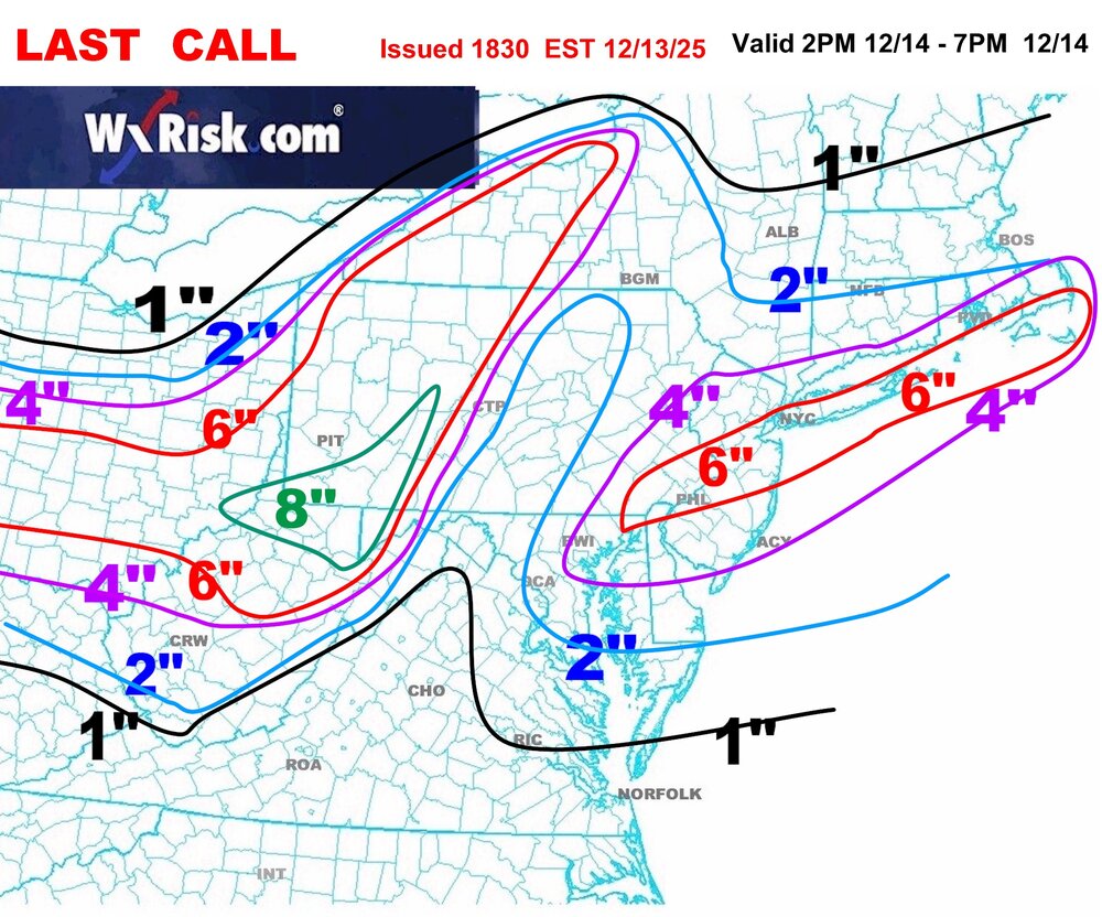
-
Light snow started 30 min ago. 35°
-

Moderate snowfall 12/14/2025 WWA up for most of the area
Dark Star replied to WeatherGeek2025's topic in New York City Metro
Actually there was a break in the radar with main batch about 40 miles still to the west?