All Activity
- Past hour
-

2026-2027 Strong/Super El Nino
40/70 Benchmark replied to Stormchaserchuck1's topic in Weather Forecasting and Discussion
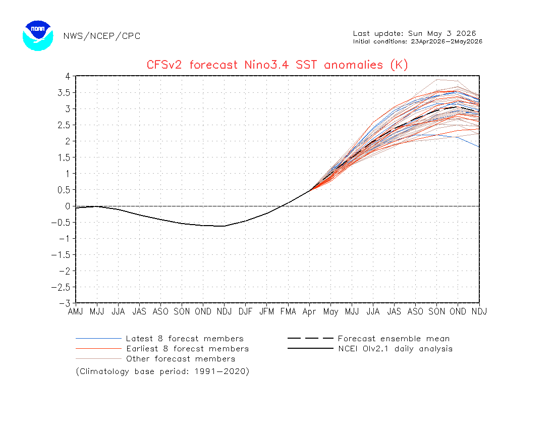
I expect to do a pretty deep-dive on the RONI/ONI relationship in my outlook this year because I feel that is going to be even more crucial than modoki index to be perfectly honest. -
Broke into some solid sun now. What a difference
-
2026-2027 Strong/Super El Nino
40/70 Benchmark replied to Stormchaserchuck1's topic in Weather Forecasting and Discussion
We'll see what happens. I think 1982-1983 is a best case scenario assuming El Niño gets as powerful as some are suggesting. Looking back at the local climo data....winter was even better than I thought. Three storms over a foot in my area. December/January/March were slightly above normal temps and February slightly below normal. Snow pack peaked at 26" on February 11th....bit more than last year. -
Cod fishy
-

2026-2027 Strong/Super El Nino
GaWx replied to Stormchaserchuck1's topic in Weather Forecasting and Discussion
But this CFS run is still showing a RONI-ONI gap of 0.5C (+2.5 vs +3.0). That narrowing is <0.1 vs the JFM gap of 0.56. -
ineeddonuts
-
2026-2027 Strong/Super El Nino
40/70 Benchmark replied to Stormchaserchuck1's topic in Weather Forecasting and Discussion
Not necessarily. -
2026-2027 Strong/Super El Nino
40/70 Benchmark replied to Stormchaserchuck1's topic in Weather Forecasting and Discussion
I like that we seem to be closing the gap between RONI and ONI....I bet we see more of an Aleutian low/SE ridge response if that is the case. 82-83 had decent NE snowfall even though it was warm in the mean. -
We can only hope. The promise of better weather this spring is reminiscent of the promise of a snow storm only 5 days away that never materializes.
-
this may have been the last winter day in the city until this fall..
-
Was gonna go out and do more yard work today. Too cold and biting with the wind, so I guess it's painting inside instead.
-
Officially I see only 0.05” at RDU for May 1-2: https://kamala.cod.edu/nc/latest.cdus42.RDU.KRAH.html Also, I see only 0.63” at FAY vs 0.91” on the map: https://kamala.cod.edu/nc/latest.cdus42.FAY.KRAH.html It’s as if they put in the wrong map. Maybe that was a forecast map?? But it has GSO right with nothing. Here’s a link to the last 7 days rainfall, which shows 0.44” at RDU, 0.77” at FAY, and 0.16” at GSO: https://kamala.cod.edu/offs/KRAH/2605031100.sxus52.html
-
Only 54 degrees here with the gusty winds. Nasty for early May. Looking forward to mid 70s tomorrow.
-
(002).thumb.png.6e3d9d46bca5fe41aab7a74871dd8af8.png)
Central PA Spring 2026 Discussion/Obs Thread
ChescoWx replied to Voyager's topic in Upstate New York/Pennsylvania
Below is from Mount Holly - Is there one from State College? Thanks! -

2026-2027 Strong/Super El Nino
snowman19 replied to Stormchaserchuck1's topic in Weather Forecasting and Discussion
Despite the wishcasting by a select few weenies on twitter trying their best to wishcast a super El Niño away by saying there is no atmospheric coupling, the actual facts and reality tell a completely different story….there is actually strong ocean-atmosphere coupling (Bjerknes feedback) and it is projected to stay that way: -
E PA/NJ/DE Spring 2026 Obs/Discussion
ChescoWx replied to PhiEaglesfan712's topic in Philadelphia Region
Final seasonal NWS reported snowfall maps -
Next 2 weeks don’t look great. May have to wait until mid June for summer weather
-
This is too much for Raleigh. I got 0.15” there is no way downtown got that much more. Also the farm in Louisburg had less than 0.20” and its SE of Louisburg on that map. So that is likely too high as well. Honestly cut these totals in half
-
NGL if the models still support some snow falling in WV I'll be taking a nice hike out there
-
2026-2027 Strong/Super El Nino
GaWx replied to Stormchaserchuck1's topic in Weather Forecasting and Discussion
Thanks, snowman. Indeed, it’s forecasting a 1982-3 redux as of now. The corresponding latest CFSv2 ONI forecast is at +3.0C, which is maintaining the recent ~0.5C difference between ONI and RONI:
- Today
-

2026-2027 Strong/Super El Nino
Maestrobjwa replied to Stormchaserchuck1's topic in Weather Forecasting and Discussion
So torch east-based super followed by another round of cool enso (which always double dips) being the worst case scenario? Sounds like a warminista's dream, smh -
Could not agree more Tip. The numbers don't lie song is highly overrated! The subject take by "non-weather geeks" like most of my friends and family, is that this spring has largely sucked. I know spring in New England is more often than not crappy. But I'm just not buying this has been a great spring spin.
-
2026-2027 Strong/Super El Nino
snowman19 replied to Stormchaserchuck1's topic in Weather Forecasting and Discussion
The new CFS RONI forecast update is projecting that we at least tie (+2.5C) for the strongest El Niño on the RONI index, which was the 1982-83 super El Niño (also +2.5C). 1982-83 ended up being slightly stronger than 1997-98 on the RONI. The CFS has the traditional ONI peaking higher than the RONI for this event, but not by much…. -
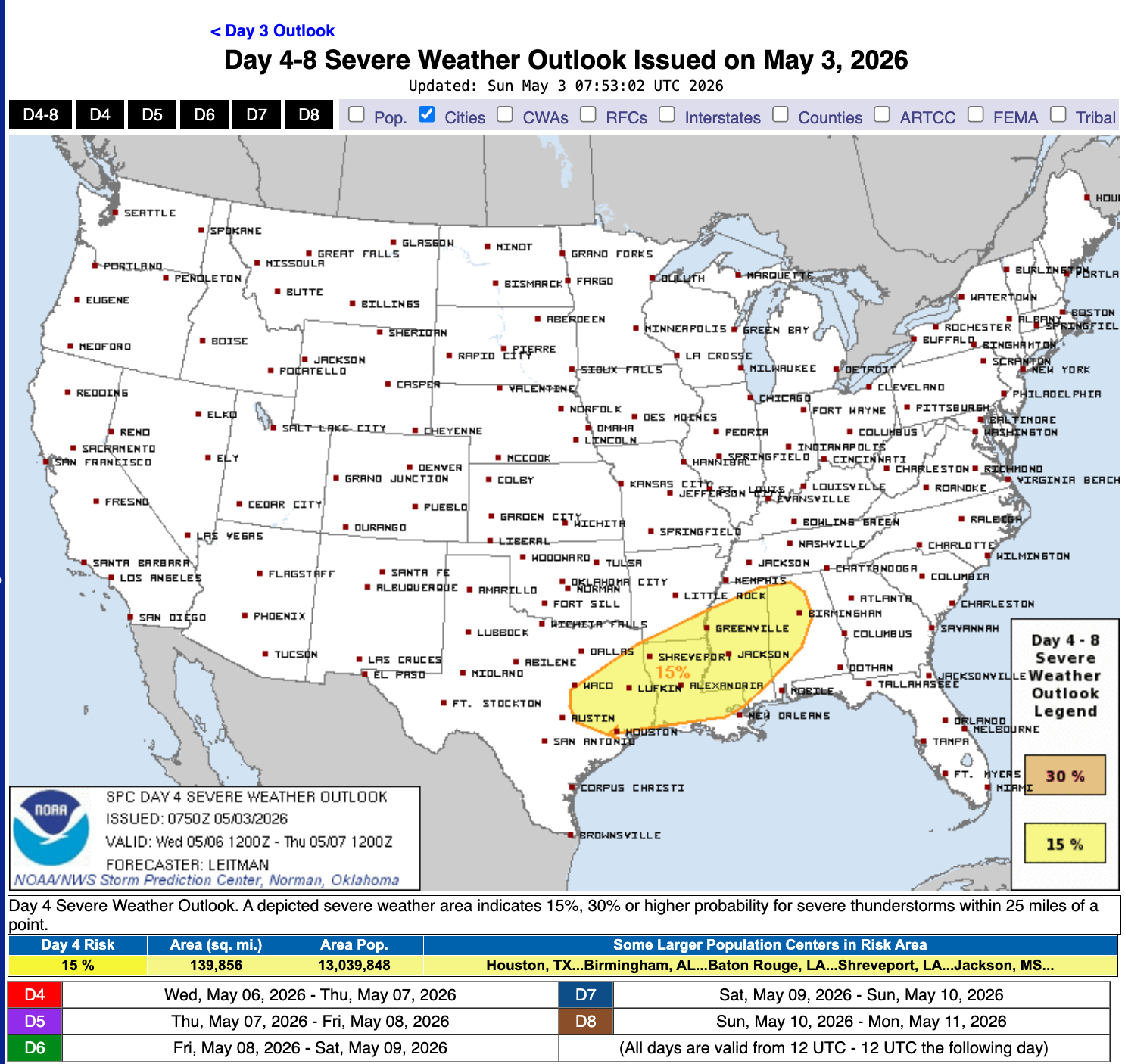
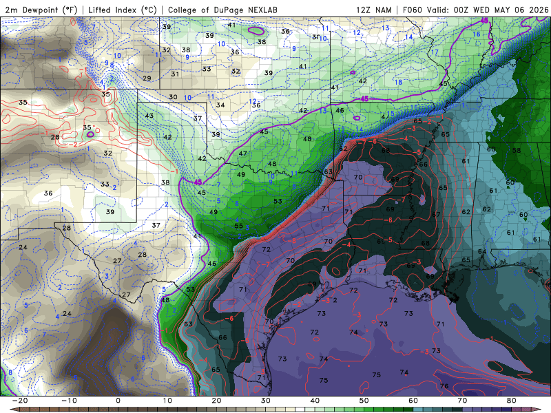
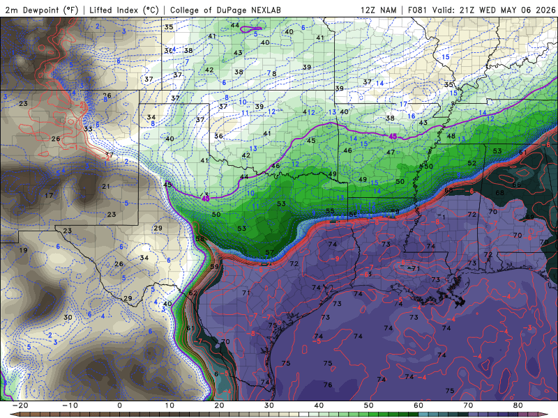
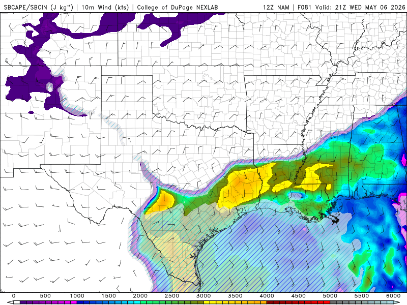
Wednesday Severe Wx Potential Looking into the model guidance this morning and it appears there could be a severe weather threat for Wednesday afternoon/evening for Central MS into eastern TX. My chase area will focus be focused within the MS/LA Delta as the terrain the region is suitable for chasing as there will be little trees and hills to obscure my view while chasing. The only factor will be the Mighty MS RVR, but that can be easily managed pending on storm track, storm mode and storm speed/motion. Beginning with 00z on Wednesday with the 12z NAM run, the frontal boundary is orientated southwest to northeast. This orientation provides a nice dividing line between the warm sector and the cold sector for storms to develop for Tuesday afternoon/evening. However, the threat for storms will be located well out of my reach and will not be able to chase on Tuesday unless the threat for severe storms extended eastward into MS Delta on Tuesday, which there is little confidence that will occur. By 21z Wednesday, the cold front will have taken over the warm front and will have a west to east orientation by 21z Wednesday. If this were to occur, any discrete or supercells will be extremely limited and will likely be dealing with a linear event, unless some outflow boundary can cause some pre-frontal convection in the warm sector for Wednesday afternoon/evening. While model guidance shows southerly winds and instability within the region for Wednesday afternoon/evening, the 850 and 925mb winds shows a weak LLJ and only a slight wind shift towards the southwest. With these factors combined, Wednesday could likely be more of a linear event and possibility for discrete cells will likely be limited at this time. At this time, I am not impress with this coming up system for a potential chase, especially this far out. While I did skip over Tuesday, I will continue to watch to see if model data will change or convince me to chase on Tuesday, but challenges for Tuesday would be more logistics based and not meteorological based at this time. For me to chase Tuesday, the threat for the MS/LA Delta will need to extend towards the region. A Day 3 Marginal Risk for severe weather does do it for me, especially when it is concentrated towards NE AR/ NW TN/MO. Date: 5/3/2026
-
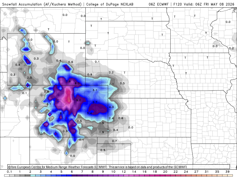
Meanwhile in DEN coming up. Scott again: " Why can't we get that here? -- I WANT A MAY 9-10, 1977 EVERY YEAR!" Interesting for DEN this snow season. They currently have more snow March-April (13.9") than meteorological winter (13.2") and more on the way. I bring this up b/c the clueless media could not stop talking about how there was a lack of snow this winter in the Rockies in Feb. However, the window for snow goes well beyond meteorological winter here, but of course the media doesn't realize this, or conveniently ignores to push hype/a narrative (no more snow). It's also the East Coast bias, as if the climate is the same everywhere and the East Coast (esp. NYC) is the standard! So even though meteorological winter was lacking for snow in the Rockies, they have made up some ground March-April, and will continue to do so short-term. The point is it no longer the record lowest for snow. Yes, still below avg, but that not the same as all-time records. These days any deviation from normal or anomaly is treated as unusual or extreme. What planet are they living on? And what do you think the headlines will be coming up in the next week? Not the unusually persistent cool wx in the East, but the "heat dome" in the West, despite the CO snowstorm.


.thumb.jpg.049f4a7f726ada07e8cd30bd17e713cb.jpg)