All Activity
- Past hour
-
It looks like a good bit of rain headed our way... again.
-
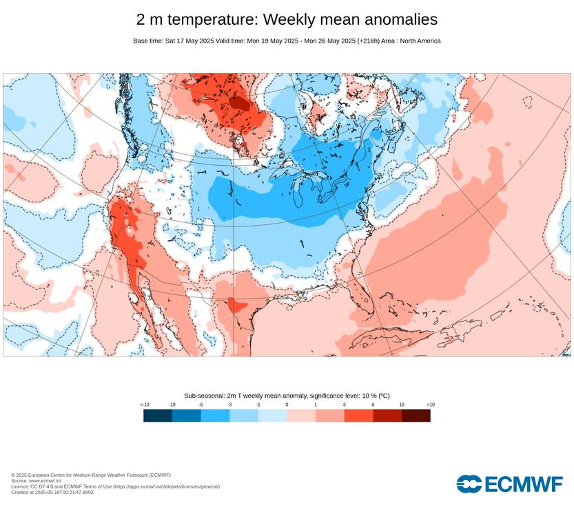
Departures through May 17th (these will be chopped in more than Half by 5/25, we'll see) JFK: +5.4 EWR: +5.0 LGA" +3.6 NYC: +3.2
-
For May in general you'll have to go back to the 3 day period in 2022 from 5/6 - 5/8 for highs in the 50s/ low 60s and raw. For later post mid may you'll need to go back 2021 5/29 and 5/20 for cool/wet days in the 50s and the same days in 2017 5/29 - 5/31 .
-
Yeah he's in New Haven probably one of the warmer towns in New England. It's almost New York.
-
Records: Highs: EWR: 94 (2017) NYC: 92 (2017) LGA: 97 (2017) JFK: 88 (1977) Lows: EWR: 43 (2003) NYC: 41 (1973) LGAL: 44 (2002) JFK: 43 (2023) Historical: 1825 - A tornado (said to have crossed all of the state of Ohio) smashed into the log cabin settlement of Burlington, northeast of Columbus. (David Ludlum) 1883: The massive tornado outbreak on record in Illinois affected the northern and central parts of the state. At least 14 strong to violent tornadoes touched down killing 52 people. The largest death toll from a single tornado was 12, with 50 injuries, from an estimated F4 tornado which moved from near Jacksonville to 5 miles west of Petersburg. This tornado destroyed the town of Literberry. Another tornado, with an estimated F4 intensity, killed 11 people and injured 50 along its path from the south edge of Springfield northeast to near Kenney. This particular tornado reportedly drove 10 inches by 12-inch oak timbers 10 feet into the ground. Another estimated F4 tornado in far northern Illinois touched down near Capron and tracked for 17 miles before lifting in far southern Wisconsin. Lastly, an estimated F4 tornado tracked 20 miles through Kenosha and Racine Counties in Wisconsin. Eight people were killed, and 85 were injured. 1915: A spring snowstorm began across parts of the east-central Rockies into parts of the west-central Plains. The storm produced 11.8 inches of snow at Scottsbluff, NE by the end of the day with 5 inches of snow recorded at Cheyenne, WY. 1960 - Salt Lake City UT received an inch of snow. It marked their latest measurable snowfall of record. (The Weather Channel) 1980 - Mount Saint Helens (in Washington State) erupted spewing ash and smoke sixty-three thousand feet into the air. Heavy ash covered the ground to the immediate northwest, and small particles were carried to the Atlantic coast. (David Ludlum) 1987 - Thunderstorms in Kansas, developing along a cold front, spawned tornadoes at Emporia and Toledo, produced wind gusts to 65 mph at Fort Scott, and produced golf ball size hail in the Kansas City area. Unseasonably hot weather prevailed ahead of the cold front. Pomona NJ reported a record high of 93 degrees, and Altus, OK, hit 100 degrees. (The National Weather Summary) (Storm Data) 1988 - Low pressure anchored over eastern Virginia kept showers and thunderstorms over the Middle Atlantic Coast Region. Flash flooding was reported in Pennsylvania. Up to five inches of rain drenched Franklin County PA in 24 hours. (The National Weather Summary) 1989 - Thunderstorms developing ahead of a cold front produced severe weather from the Central Gulf Coast States to the Lower Missouri Valley during the day and evening. Thunderstorms spawned sixteen tornadoes, and there were 74 reports of large hail and damaging winds. (The National Weather Summary) (Storm Data) 1990 - Thunderstorms produced severe weather in the central U.S. spawning a sixteen tornadoes, including a dozen in Nebraska. Thunderstorms also produced hail four inches in diameter at Perryton TX, wind gusts to 84 mph at Ellis KS, and high winds which caused nearly two million dollars damage at Sutherland NE. Thunderstorms deluged Sioux City IA with up to eight inches of rain, resulting in a record flood crest on Perry Creek and at least 4.5 million dollars damage. (The National Weather Summary) (Storm Data) 1995: A severe weather outbreak occurred in the Ohio and Mississippi Valleys. 86 tornadoes were reported; five F4 intensity. his was one of the largest tornado outbreaks in two decades in Tennessee. 6 people were killed and 65 others injured. Three people were killed at Ethridge, TN. A tornado causing F2 damage touched down near Festus, MO causing almost $200,000 dollars in damage. An F2 tornado touched down on the eastern shore of the Chesapeake Bay, one mile south of Cordova in the Kittys Corner area, destroying two homes. 2002: An unusually cold air mass for mid-May brought many record lows to the Midwest, Plains and South along with unseasonable snows to the Northeast. Some record lows included: Hibbing, MN: 22°, International Falls, MN: 24°, Houghton, MI: 24°, Fargo, ND: 25°, Grand Forks, ND: 25°, Bismarck, ND: 26°, Pierre, SD: 26°, Huron, SD: 26°, Minot, ND: 27°, Duluth, MN: 28°, Madison, WI: 28°, Sioux Falls, SD: 30°, Norfolk, NE: 30°, Valentine, NE: 30°, Hill City, KS: 30°, Wausau, WI: 30°, Rockford, IL: 31°, Milwaukee, WI: 33°, Bluefield, WV: 33°-Tied, Lincoln, NE: 34°, Chicago-O'Hare, IL: 34°, , Burlington, IA: 35°, Cedar Rapids, IA: 35°, La Crosse, WI: 35°, Quincy, IL: 35°, Akron, OH: 35°, Columbia, MO: 35°, Blue Hill, MA: 35°, Dubuque, IA: 35°-Tied, Des Moines, IA: 36°, Springfield, MO: 37°, Boston, MA: 37, Pittsburgh, PA: 37°-Tied, Springfield, IL: 38°, Joplin, MO: 39°, St. Louis, MO: 39°, Paducah, KY: 39°, New York (LaGuardia), NY: 44°-Tied. A late season snow occurred over the Northeast. Prattsville, NY recorded 8 inches. 2.2 inches fell at Albany, NY for its latest measurable snowfall on record. Snow fell as far south as northern Pennsylvania.
-
2010 to 2018 wasn’t natural variability since the reason the snow increased was due to the warmer atmosphere holding more moisture while the storm tracks remained cold.
-
65 / 48 off a low of 57. Partly cloudy - could be period of mostly cloudy but otherwise a nice dry - breezy low - mid 70s. Much of the same Mon and Tue dry / partly cloudy near normal. Wed - Fri - cloudy, cool , wet - ugly 72 hour stretch by mid/late may standards, Highs not budging from the 50s - E/ENE/NE flow. The weekend looks to be somewhat salvage - Saturday lingering clouds and drying out but cool, with a pleasant Sunday / Monday near normal / slightly below. Trough stingy into the NE through the close of the month. Building heat into the wets builds east and north of us, as the next month with gowing opportunities for warmth to move in. 5/18 - 5/20 : Dry. Near normal 5/21 - 5/23 - 24 AM : Miserable stretch - rain , cool, windy -10 to -12 below normal 1.00 - 1.75 inches of rain 5/24 PM - 5/28 : Drying out near normal / slightly below
-
Spring has been well above normal thus far. CC can cause cutoff lows due to the anomalous blocking. The rest of the country is torching. We're the island in the ocean of warmth.
-
Definitely a gradient between you and SoP.
-
Elon broke it
-
Vis satellite insn't offering a lot of confidence in the sun here. It's possible but the clearing may stall southwest of here. At least it's not raining and foggy. Spring is the season that doesn't take place in coastal maine.
-
Gfs is unusable.
-
I’m talking about next week.
-

2025-2026 ENSO
Stormchaserchuck1 replied to 40/70 Benchmark's topic in Weather Forecasting and Discussion
Not really a big deal imo in the context of this conversation. The PNA has been negative, and the NAO has been positive. There's a +1-2 global warming happening but that's the everything -
That Midwest warmth in March 2012 was more historic than the cold in 2015 was. The few months with -10 or more departures the CONUS since 2015 have been few and far between compared to the months over +10. This is a CONUS wide phenomenon and not just limited to one region. You can see how getting a +10 month nearly every winter since the 2015 higher temperature reset has become the norm while extreme cold is very isolated to places like Montana. Plus our Arctic outbreaks have shrunk the geographic footprint. So an Arctic outbreak into the Plains doesn’t extend all the way to the coast like it did as recently as the 1990s. Dec…2015….NYC….+13.3 JAN…2017….BTV…..+11.0 FEB….2017….ORD….+10.3 FEB…..2018…ATL….+10.6 FEB….2019…MGM….+10.5 JAN….2020…YAM….+9.8 DEC….2021….DFW….+13.2 JAN….2023….DXR….+12.3 FEB….2023…..SSI…..+9.8 DEC….2023….INL…..+15.8 FEB…..2024….FAR…..+17.5 DEC….2024…..LND…..+11.3
-
Even your beloved AI has come SE somewhat . Enough that it delivers a fairly solid weekend
-
I know most of you will enjoy it, but I wonder if what we're seeing will be the general theme of the entire summer. In my highly uneducated theory, the pattern that developes in May seems to carry through most of the summer season. Just as you guys like your winters to be winters, with cold and snow, I like my summers to be actual summers, with generally warm to hot days, broken up by occasional late day thunderstorms.
-
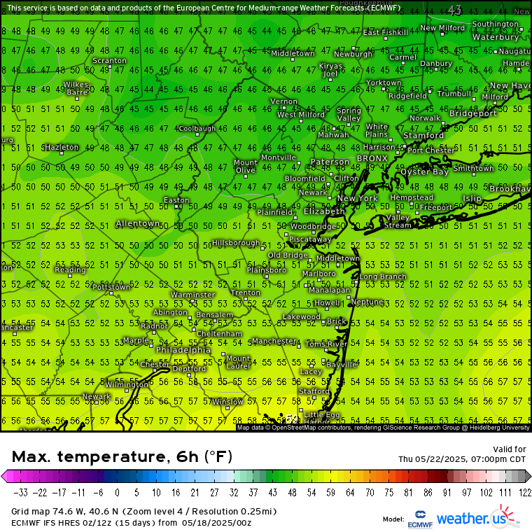
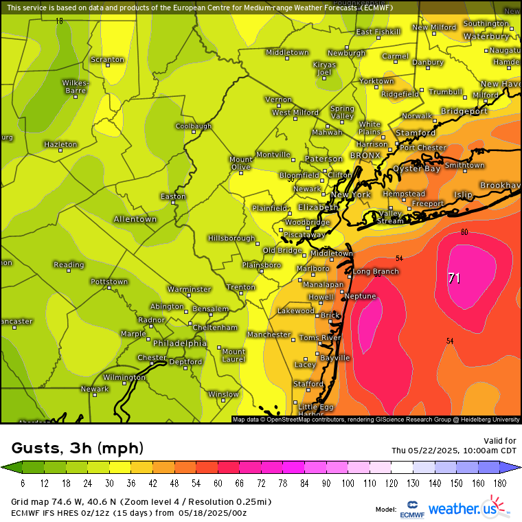
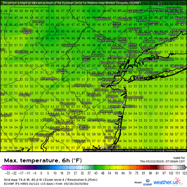
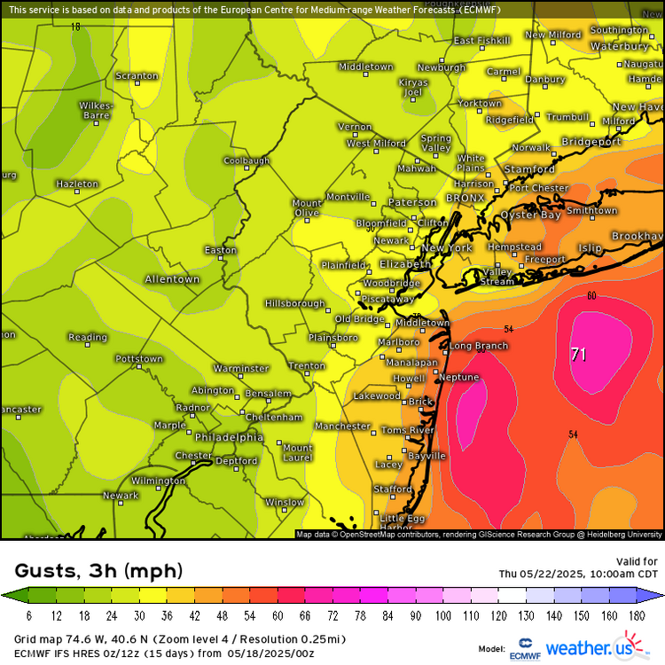
Could be the best Noreaster of 2025 this week. While the Euro may be overdone on the intensity, the gradient should be tight enough for easterly gusts over 40 and very rough surf and wind driven heavy rain potential. It’s possible that with the low clouds and easterly flow, that some spots may not get out of the 40s for afternoon highs. This is impressive cold for late May when the average daily high is 73°.
- Today
-
They won’t be right.
-
It followed the record breaking super El Niño of 15-16. The only reason the La Niña developed was because of the very strong -IOD that formed in the summer and fall or it would have been a 2nd year El Niño. That Nino was so strong that it completely altered the normal QBO progression, instead of progressing to a -QBO, which should have happened, it flipped right back to a +QBO that fall/winter
-
GEFS and Gfs farther SE with low track this week. Hope they right
-

2025 hurricane season forecast contest -- enter by June 1st
cnimbus replied to Roger Smith's topic in Tropical Headquarters
17/7/4 -

2025-2026 ENSO
PhiEaglesfan712 replied to 40/70 Benchmark's topic in Weather Forecasting and Discussion
Yeah, I don't recall any blizzards in 16-17. That one was a very low snowfall season, especially south of Philly. If I remember correctly, places like Baltimore and DC got like 3 inches of snow, putting it on par with low snowfall years like 11-12 and 12-13. -
I’m still getting rain draining through the bird poop in my gauge. Up to 0.95”
-
I don’t know the answer but this spring has been really bad for me, but yesterday was off the charts. I’m scraping crud from my eyes as I type this.