All Activity
- Past hour
-
Tbh I don’t actually consider 21-22 a dud, some places cashed in nicely and those who didn’t had just plain bad luck. However, the chance for another dud is very real and unfortunately that’s how the data is presenting itself currently. But I think that would be too easy. I believe there will be a surprise X factor (maybe the NE pac warm blob?) that throws a wrench into the standard nina/-pna climo progression to keep us in the game.
-
In Selbyville DE visiting my sister. Was a beautiful day yesterday, today shaping up to be just as lovely ahead of whatever rain comes
-
What's the problem with a 7.69% accuracy rate??
-

Occasional Thoughts on Climate Change
donsutherland1 replied to donsutherland1's topic in Climate Change
The following seems to describe their M.O.: 1) If presented by counterarguments, they largely ignore the counterarguments or, in infrequent cases of response, make broad claims that the arguments are incorrect, they shift goal posts, etc. 2) If presented with data and links to the data or scientific literature that anyone can access, that crosses a "red line." They seem to have a mortal fear about others having the ability to access the data or literature, perhaps because they know that their own view is hollow unsupported conjecture. Access to data is far more dangerous to their view than simple counterarguments. -
Finished with a much appreciated 2.07", a significant overperformer to be sure. Northwest winds gusting over 35mph with that deform in Chicagoland. Definitely would be pretty wild if were the white stuff.
-
There's little reason to be positive for my area. We haven't reached winter storm warning criteria since 2022 and that was the only time it has been reached since 2018. This is the biggest snow drought in modern history for this area. 16 inches of snow in 7 winters. 11 of that in one storm. Take that storm away and it's 5 inches of snow in 7 winters. 4 of those winters with 0 snow. With the way this winter is setting up, I would be surprised to get a winter storm warning event.
-
Who is ? Its only October . No one can get anything accurate this far out.
-
Man three duds. Hope you're dead wrong.
-
The MJO is really favorable for development in the Western Caribbean. We will just have to wait and see how much interaction there is with the trough forecast to be near the Great Lakes. Maybe the cutoff event last weekend was the beginning of a wetter pattern for our area.

-

Spooky Season (October Disco Thread)
DavisStraight replied to Prismshine Productions's topic in New England
My dog got stung by one yesterday -
I’ve had my eye on 17-18 as well, in addition to 21-22. I’m on the fence about 22-23, but if I’m going to include that analog I feel the need to balance that with either 13-14 or 24-25, maybe even both. Sensibly for us that might mean a couple of months with NN/BN temps and fairly dry, and at least one torch month. Hopefully we get some blocking and some moisture to keep things interesting tracking-wise.
-
(002).thumb.png.6e3d9d46bca5fe41aab7a74871dd8af8.png)
Central PA Fall Discussions and Obs
ChescoWx replied to ChescoWx's topic in Upstate New York/Pennsylvania
One last mild above normal temperature day today before some showers arrive after midnight tonight and turn us back to below normal temperatures for the rest of the upcoming week. Rain tonight looks like between 0.25" to 050" across the area. The only other chance of rain this week looks to be Tuesday night. Highs looks to be in the 50's and lows in the 30's for much of the late week period.
-
E PA/NJ/DE Autumn 2025 Obs/Discussion
ChescoWx replied to PhiEaglesfan712's topic in Philadelphia Region
One last mild above normal temperature day today before some showers arrive after midnight tonight and turn us back to below normal temperatures for the rest of the upcoming week. Rain tonight looks like between 0.25" to 050" across the area. The only other chance of rain this week looks to be Tuesday night. Highs looks to be in the 50's and lows in the 30's for much of the late week period.
-
https://x.com/mikemasco/status/1979560684976500739?s=61
-
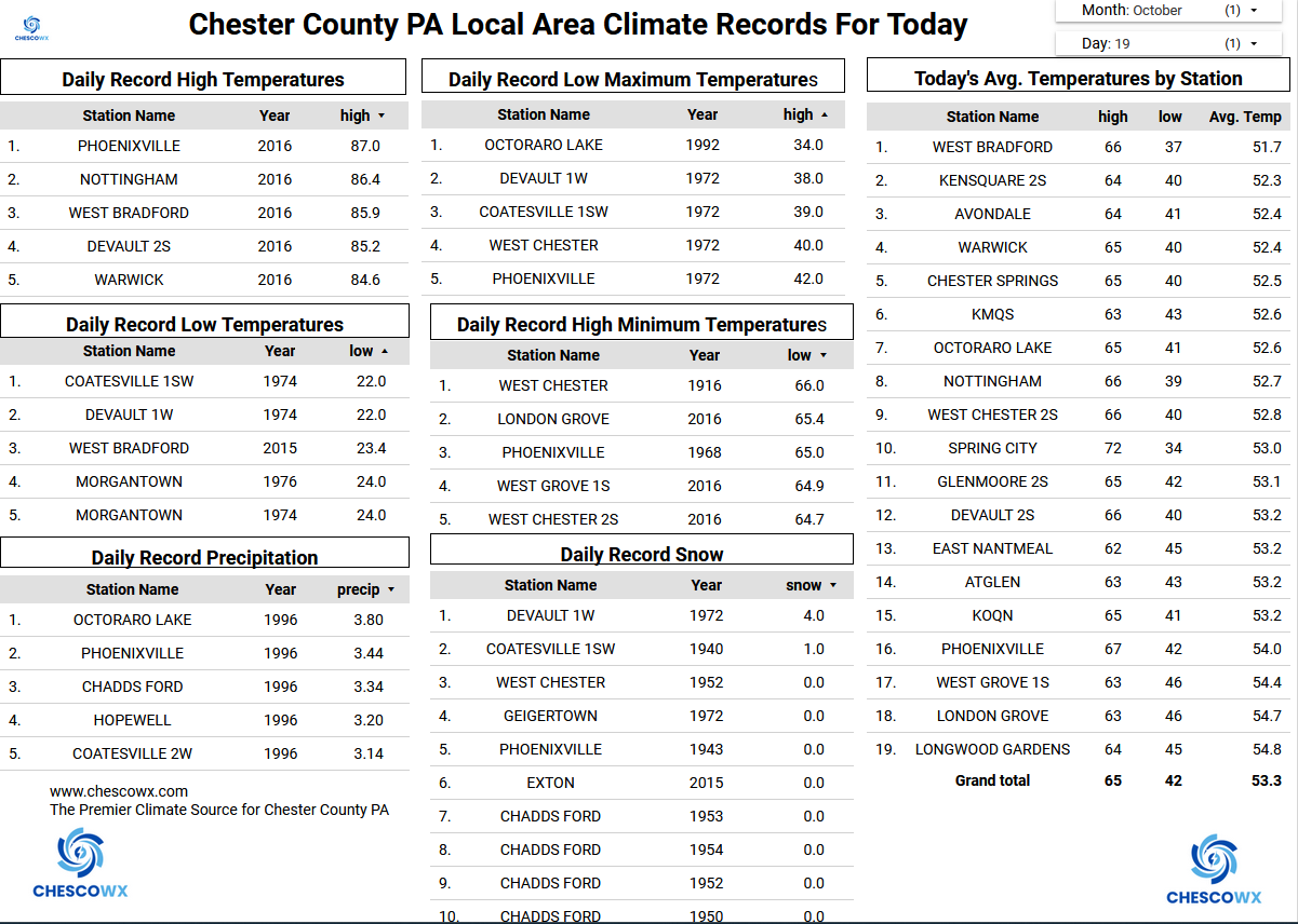
Got it! You can't find any proof in the Chester County data to undermine the quality of the data....unless we go hundreds of miles away - check!!
-
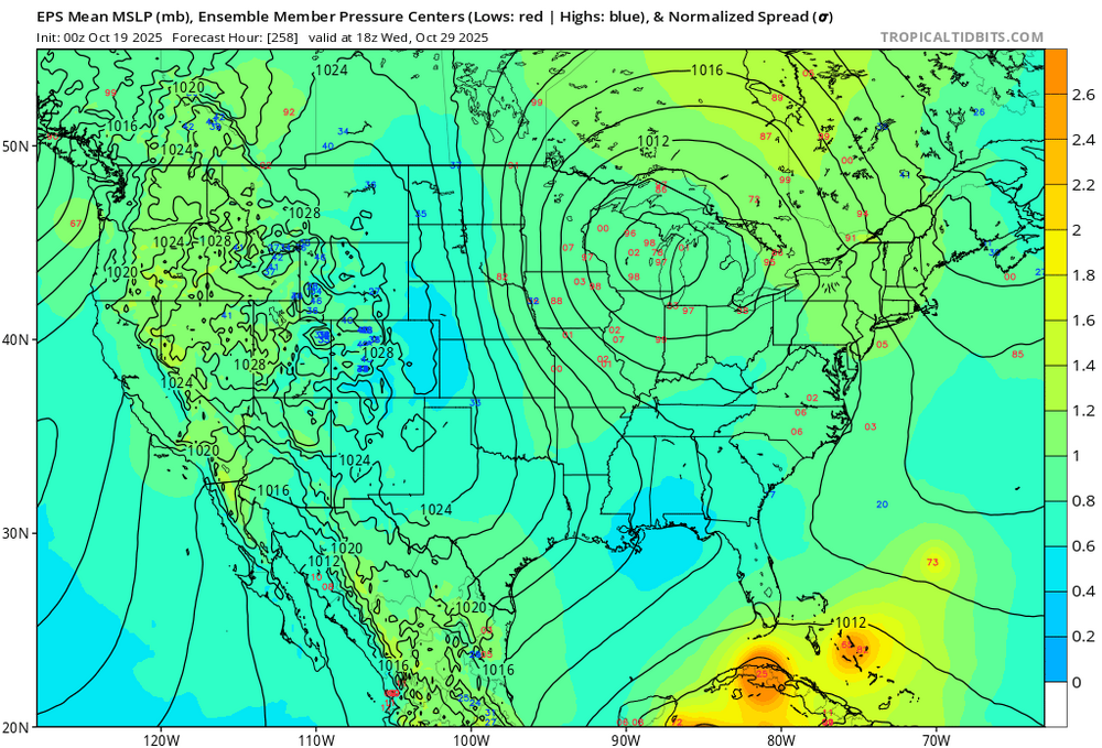
The operational ECMWF certainly does before bringing a captured tropical cyclone into Maine and then northwestward from there. The proverbial pieces could be available. It will be interesting to see if we wind up getting tropical-enhanced rainfall, even if just through a frontal passage.
-
Wonder if we can actually tap some tropical moisture later in the month? We haven’t been able to do this in a while. Probably just have wait and see what comes of the potential Western Caribbean development.

-

Spooky Season (October Disco Thread)
bobbutts replied to Prismshine Productions's topic in New England
Lots of streams around Bow have been totally dry or just stagnant pools of water. Been hiking in the area for years and had never seen them dry until this season. -

Spooky Season (October Disco Thread)
CoastalWx replied to Prismshine Productions's topic in New England
Only thing we watch is a deep trough nearby. At least as currently modeled, that appears to be on the table. -
Spooky Season (October Disco Thread)
CoastalWx replied to Prismshine Productions's topic in New England
When are there not weenie members. -
What should become Melissa may be something to watch in the 10/28 - 11/3 period.
-
Yes, we're watching it today. DM me if you're up there next year, our barn gets a tent on Saturday near jump 16/25 and you'd be welcome to stop by!
-
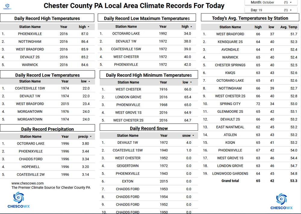
Records: Highs: EWR: 87 (2016) NYC: 85 (2016) LGA: 86 (2016) JFK: 86 (2016) Lows: EWR: 30 (1976) NYC: 30 (1940) LGA: 32 (1940) JFK: 31 (1976) Historical: 1749: A tremendous hurricane tracked offshore Virginia, northeast to Cape Cod. At 1:00 a.m. at Norfolk, winds became violent from the northeast. The fury of the storm peaked between 10:00 a.m. and 2:00 p.m.. In Williamsburg, one family drowned as flood waters carried their house away. At Hampton, water rose to four feet deep in the streets; many trees were uprooted or snapped in two. Torrents of rain flooded northern Virginia and Maryland. The Bay rose to fifteen feet above normal...destroying waterfront buildings. An account of this tremendous storm was given in the biography of Commodore James Barron, An Affair of Honor, by William Oliver Stevens. Barron's grandfather witnessed the hurricane first hand while stationed at Fort George. The account is as follows: "A threatening sky was observed to the southeast over the Chesapeake Bay. The wind increased which soon brought the rain. As the hours wore on the wind and rain increased in fury. Sometimes the downpour slackened. One could hear the sand picked up by the wind from the beach outside and blasted against every object that still withstood the gale. All the while the rising tide was rapidly being piled up to a height never seen before in that area. The waves were pounding on the shore, finally to the very foot of the outside wall at Fort George. A large tree crashed over on its side with its roots in the air and was driven against the land side of the Fort. With the impact the wall yawned and broke. Shortly afterwards the seawall lurched and sank at the point where it was exposed to the wave fury of the storm. Finally the outside wall of the fort gave way, and the filling of sand poured out, leaving the inner wall exposed to the blast without support. When this too fell apart and collapsed, the barracks took the full force of the wind. About sundown, the storm slackened and in another hour the rain and wind had diminished to such a degree that it was clearly spent. " The next morning Commodore Barron swept the distant waters with his spy glass. He was astonished to see across Hampton Roads a wide, sand promontory which had not existed there before. A sand spit had been thrown up during the fury of the storm, which was the beginning of Willoughby Spit. (Ref. Hurricane of 1749) (Ref. AccWeather Weather History) 1844 - The famous "Lower Great Lakes Storm" occurred. Southwesterly winds were at hurricane force for five hours, driving lake waters into downtown Buffalo NY. The storm drowned 200 persons. (David Ludlum) 1940: 2.2 inches of snowfall was recorded at Philadelphia, PA starting on this date and ending on the 20th, for the highest amount of snow received from a storm in October. The maximum 1.7 inch snow depth measured is an October record. Baltimore, MD received 0.4 inches on this day and 0.9 inches on the 20th. Washington, DC received just a tenth of an inch of snow on this date followed by 1.4 inches on the 20th. (Ref. Wilson Weather History) 1961 - Rain changed to a record early season, heavy wet snow over the southern mountains of West Virginia. Leaves were still on trees, resulting in the worst forest disaster since the fires of 1952 and 953. One to two feet of snow fell near Summersville and Richwood. (19th-20th) (The Weather Channel) 1984 - Thunderstorms deluged the town of Odem, TX (located 15 miles northwest of Corpus Christi) with 25 inches of rain in just three and a half hours. Most businesses in Odem were flooded, as were 1000 homes in nearby Sinton. (The Weather Channel) 1987 - A cold front brought rainshowers to parts of the central U.S., and ushered cool Canadian air into the Great Plains Region. Daytime highs were only in the 30s in North Dakota and eastern Montana. (The National Weather Summary) 1988 - Thunderstorms produced high winds in eastern Colorado, with gusts to 63 mph reported at La Junta. (Storm Data) (The National Weather Summary) 1989 - Record breaking snows fell across northern and central Indiana. Totals ranged up to 10.5 inches at Kokomo, and 9.3 inches was reported at Indianapolis. The 8.8 inch total at South Bend was a record for the month as a whole. Up to seven inches of snow fell in extreme southern Lower Michigan, and up to six inches fell in southwestern Ohio. The heavy wet snow downed many trees and power lines. Half the city of Cincinnati OH was without electricity during the morning hours. Temperatures dipped below freezing across much of the Great Plains Region. Twenty cities, including fourteen in Texas, reported record low temperatures for the date. North Platte NE reported a record low of 11 degrees. In Florida, four cities reported record high temperatures for the date. The record high of 92 degrees at Miami also marked a record fourteen days of 90 degree weather in October, and 116 such days for the year. 1990: A tornado damaged an apartment complex and shopping center near Baltimore, MD. (Ref. AccWeather Weather History) 1996: The opening game of World Series between the Braves and Yankees in New York was postponed by heavy rains and high wind from a major storm system affecting the East Coast, marking the third time in history that the World Series opener had been postponed. Overall, nine of the 22 games that have been canceled in Series history were scheduled in New York or Brooklyn. 2005: Hurricane Wilma pushed the 2005 season to the most active ever recorded, added another entry to the record books. The central pressure of this Category 5 storm fell to 882 millibars or 26.05 inches of mercury, the lowest minimum pressure ever measured in the Atlantic basin. Its maximum sustained wind peaked at 185 mph. (Ref. Wilson Weather History)
-
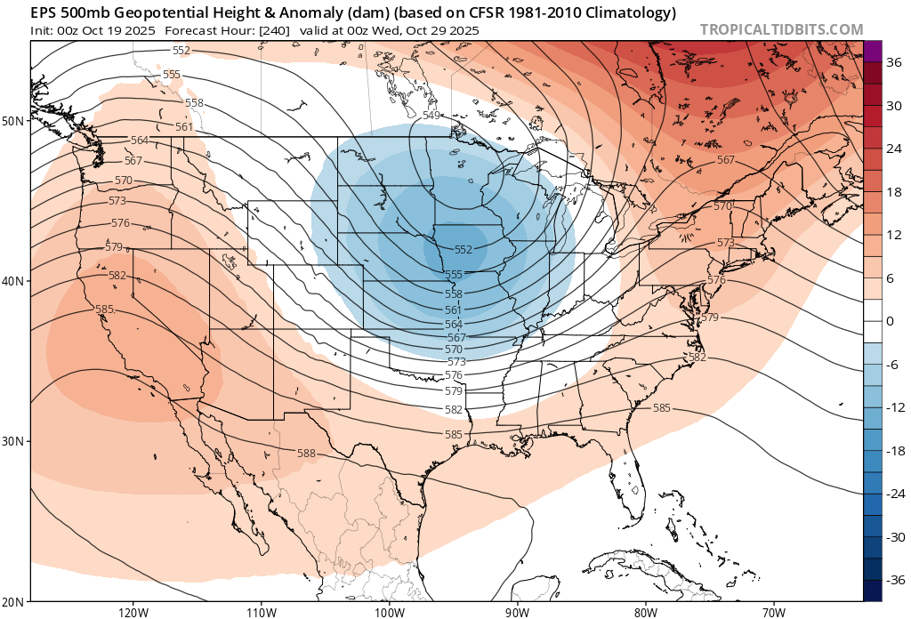
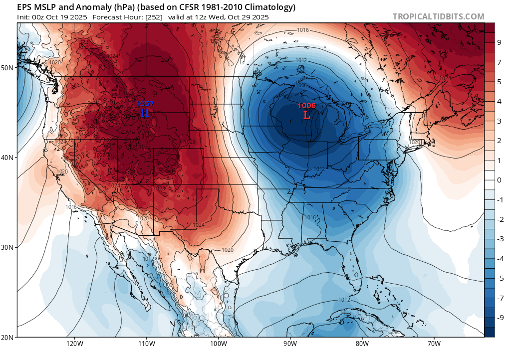
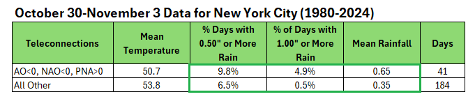
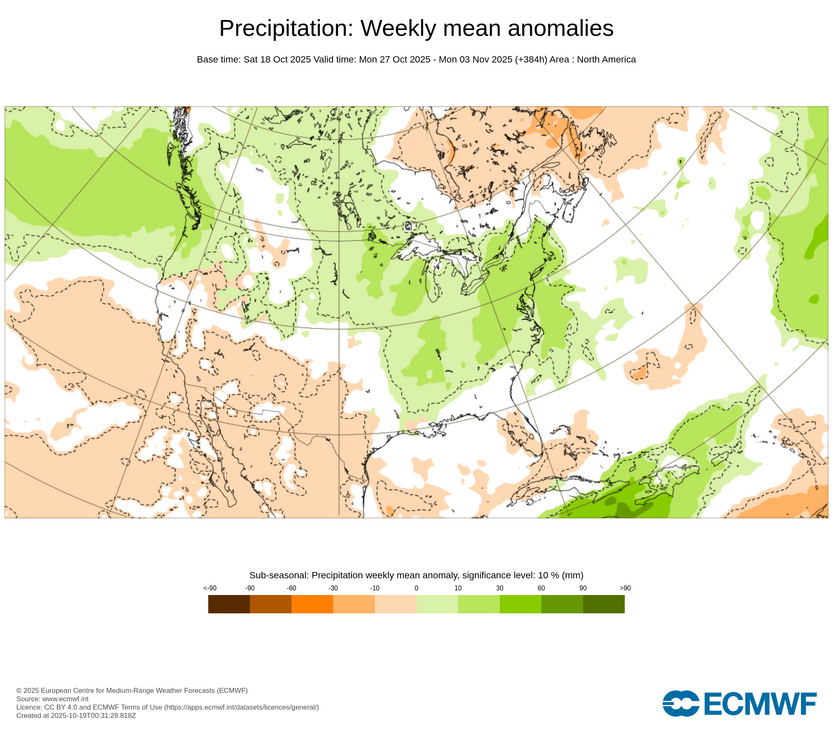
The latest teleconnection forecast calls for a negative AO, negative NAO, and positive PNA in the closing days of October and opening days of November. Such a combination can favor a period of wetter weather. The latest ECMWF weekly forecast for October 27-November 3 shows wet anomalies. It should be noted that the Week 2 CFSv2 anomalies are on the dry side of normal. Therefore, at least for now, the period merits watching, but there remains considerable uncertainty. I suspect that the odds are somewhat more in favor of the ECMWF outcome given historic outcomes, but that won't become clearer until the operational guidance moves into its high-skill forecasting range.
-
My daughter who rides is home on her fall break. Told her next year if it is during her fall break we will take a drive over to watch. Nice that MPT was/is showing it live on their broadcast.