All Activity
- Past hour
-
Not sure about "big" per se... but I agree. I explained this yesterday/why... at the time, the signal is/was mostly numeric, with some hint in the actual spatial synoptics of the general ensemble means. The operational models were, and in some cases still are, lagging a bit on that. The 00z Euro's extended is now just detecting the change. It's got some spuriously oddly wrapped cyclones where it shouldn't but removing those and normalizing the for the height changes is 80/60 from IND-BOS in real seasonal move. We'll see if the others begin to do so.
-

2026-2027 Strong/Super El Nino
Stormchaserchuck1 replied to Stormchaserchuck1's topic in Weather Forecasting and Discussion
Nino 1+2 was almost 0.0 in 09-10. -
Still 47F in Boston Harbor. Waters actually really cooled off this winter.
-

2026-2027 Strong/Super El Nino
PhiEaglesfan712 replied to Stormchaserchuck1's topic in Weather Forecasting and Discussion
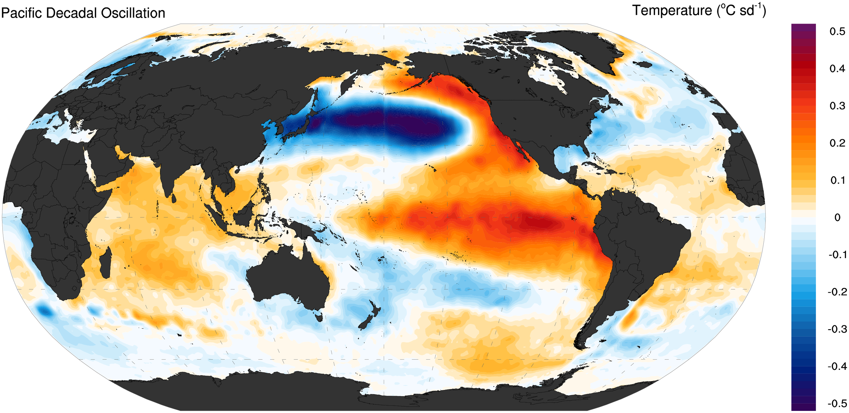
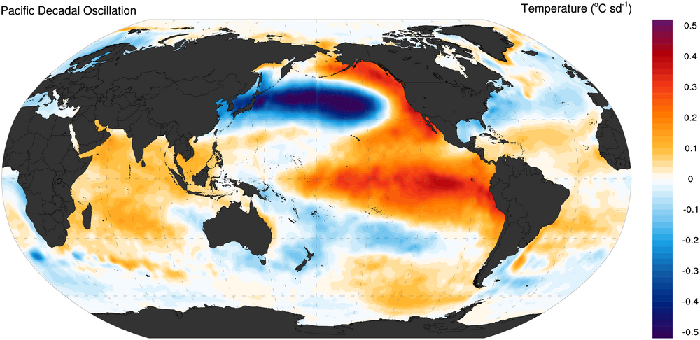
The PDO being in the slightly negative/neutral range gives me hope. The PDO was like that in 2009-10. It just comes down to blocking pattern. If we can get a blocking pattern like 09-10, then maybe, just maybe, we could get a great winter out of this. 09-10 I believe was also a strong +PMM winter, too: https://psl.noaa.gov/data/timeseries/month/data/pmm.data -
Not sure it matters as an augment or not but it may be worse than usual. It seems we've been through an unusually proficient upwelling circumstance along the interface water where the Labradorian flow abuts the warmer Atlantic. Those 'tuck' waters running parallel to the coast out there are impressively colder than normal according to this source: https://climatereanalyzer.org/wx/todays-weather/?var_id=sstanom&ortho=1&wt=1 so yeah...intuitively that S or even SSW is unusual. I wonder if this also the case NW Pacific. From the vantage provided above, ...we are uniquely cold abused. F'n weird... air and sea since last October is like a cold targeting attack right here
-

2026-2027 Strong/Super El Nino
bluewave replied to Stormchaserchuck1's topic in Weather Forecasting and Discussion
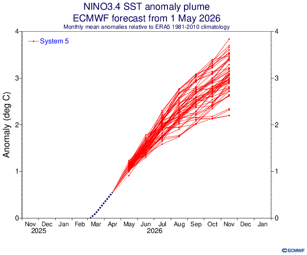
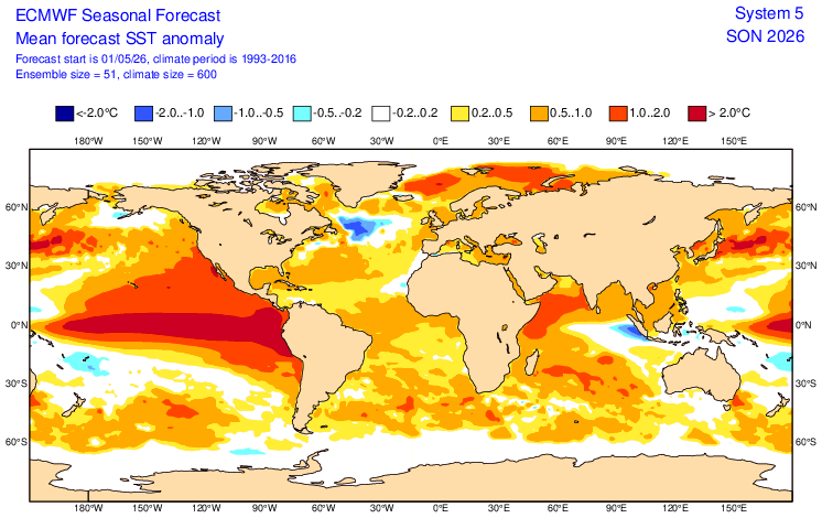
The Euro is coming in stronger with the El Niño following the near record upper ocean heat for so early in an event. It still maintains the warm pool east of Japan. But it also has a very strong +PMM. So maybe the PDO will be in the negative to perhaps neutral range. But probably not the strong +PDO of 2015-2016 and 1997-1998. Right now it looks like the floor for this event is 2.1 to 2.4 on the ONI. The ceiling could be above 2.5 to maybe closer to 3 like we saw back in 2015-2016. Will probably depend on how strong the WWBs are from the summer into the fall. +PDO pattern
-
Um yea SW/SSW arent the best here early in the season, especially. But 60's is doable in May. As long as we flush the 40-50° crap out of here I'm good.
-

Central PA Spring 2026 Discussion/Obs Thread
mahantango#1 replied to Voyager's topic in Upstate New York/Pennsylvania
You got it! -
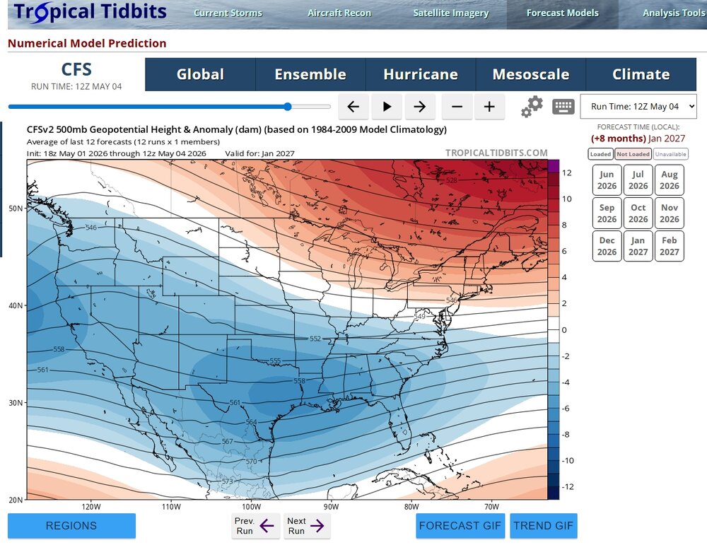
Not super confident on CFS this far out, but this winter, if depicted right or similar, could be interesting in SE. January below of course, but December-February is an interesting period on CFS but probably changing some. Do not recall seeing this much below heights in SE in sometime. Still fun to watch.
-

Central PA Spring 2026 Discussion/Obs Thread
pawatch replied to Voyager's topic in Upstate New York/Pennsylvania
53 degrees this morning. Maybe few pop up showers this morning. -

Central PA Spring 2026 Discussion/Obs Thread
Blizzard of 93 replied to Voyager's topic in Upstate New York/Pennsylvania
Bob Seger lyrics? - Today
-
Another factor to your local forecast. UHI + DCHI I do believe this already impacts locations downwind…à la imby
-
barry the goat
-
56° already Meanwhile a low of 31° at BML
-
Thanks for pointing this out. There was some talk on social media that the total was being reviewed since it was higher than the other surrounding sites. The same thing happened back in 2016. https://www.facebook.com/danzarrow/posts/blizzard-of-2026-recap-the-numbers-are-in-and-they-have-now-been-thoroughly-chec/1443908300437997/ The historic 27.2" total at Newark Airport does appear on this map, but it is highly suspect when compared to its neighbors - it is being investigated. https://www.noaa.gov/media-release/review-of-jan-2016-blizzard-preliminary-snow-totals-validates-dc-measurement The snow team invalidated the preliminary record measurement of 28.1 inches at New Jersey’s Newark International Airport. The team found that snow was measured hourly instead of the standard procedure of measuring every six hours, which led to an inflated preliminary total. Meteorologists at the National Weather Service will follow a scientific method to determine the accurate total before it is sent to NOAA’s National Centers for Environmental Information for certification. The old Newark snowfall record of 27.8 inches set in 1996 stands. Maximum 2-Day Total Snowfall for NEWARK LIBERTY INTL AP, NJ Click column heading to sort ascending, click again to sort descending. 1 27.8 1996-01-08 0 2 26.0 1947-12-27 0 3 25.9 1947-12-26 0 4 24.3 2016-01-23 0 5 24.2 2010-12-27 0 - 24.2 2016-01-24 0 6 23.9 2026-02-23 0 7 22.6 1961-02-04 0 8 22.3 2003-02-17 0 9 21.3 2006-02-12 0 10 20.8 1921-02-21 0 - 20.8 1921-02-20 0
-
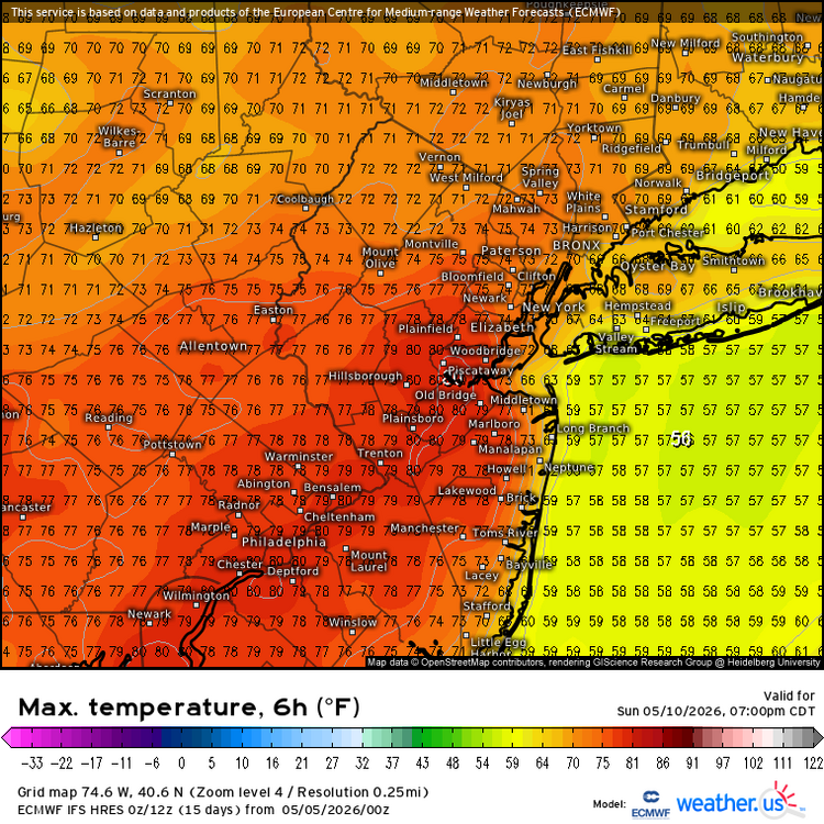
70-75 Mothers Day
-

Central PA Spring 2026 Discussion/Obs Thread
Mount Joy Snowman replied to Voyager's topic in Upstate New York/Pennsylvania
59 when I left the house. A hot one today before the rain comes. -
Tend to agree. Selling now signals a hard reset. But there is something wrong at the core of the organization.
-
Central PA Spring 2026 Discussion/Obs Thread
mahantango#1 replied to Voyager's topic in Upstate New York/Pennsylvania
Had thunder and lightning and a few drops around 2am. I woke last night to the sound of thunder"How far off?" I sat and wondered -
Sub 70 temps through June 1 on SSW/SW winds low level WAD would piss me off to no end in these pahts. Couldnt live here. Portland is often in that zone, as much as I love that city.
-
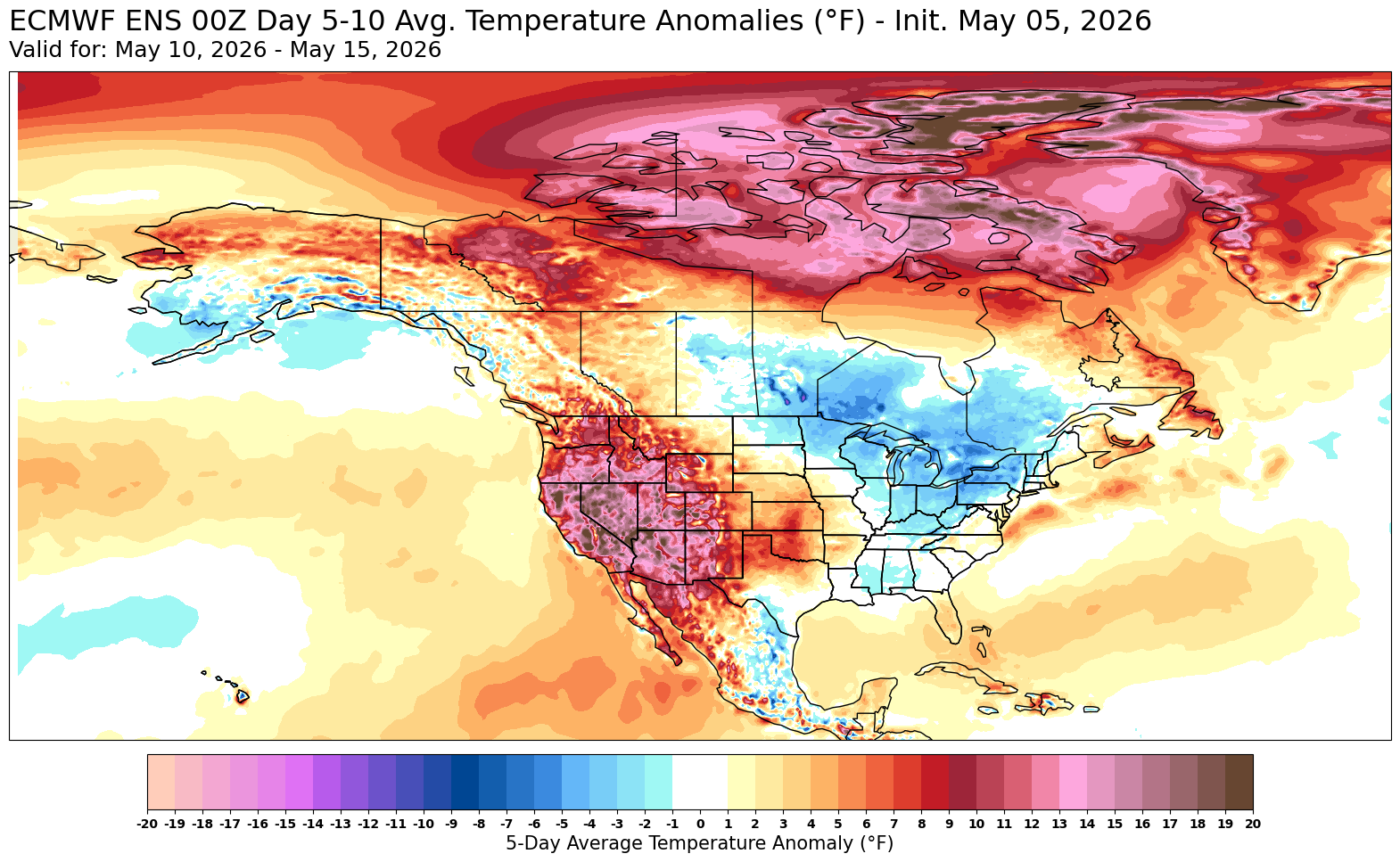
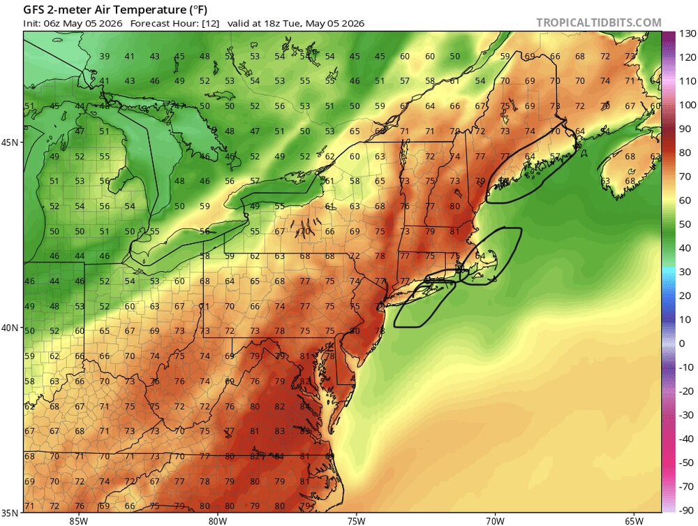
Looks like the warm spots make a run on 87° today. Next chance for 80 appears to be on Sunday. The coolest temperatures relative to the means will be over the Great Lakes and Upper Midwest behind the cold fronts.


-
SW wind events tend to do a lot of damage.. especially with leaves on trees
-
2026-2027 Strong/Super El Nino
Stormchaserchuck1 replied to Stormchaserchuck1's topic in Weather Forecasting and Discussion
And since November every composite for "before an El Nino the next year" has worked out perfectly - probably the best 6 month running composite match on record. It may take a +4.0c ONI El Nino to dominate a N. Pacific low like 82-83 or 97-98 though -
Gonna be nice today except for the 50mph winds lol. Finally feels close to summer.
-

2026-2027 Strong/Super El Nino
snowman19 replied to Stormchaserchuck1's topic in Weather Forecasting and Discussion
This El Niño just started Even JB admits it’s coming