All Activity
- Past hour
-
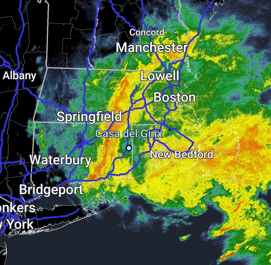
Def looks like something now.
-
The warm spots topped out in the upper 80s. This delayed first 90° could mean that the warm spots like Newark could avoid a top tier summer for 90° days. The only season following a May with no 90° days to reach 40 days of 90° highs was 1983. But that was a super El Niño and this is a La Niña. If Newark can go on to avoid a very high 90° day count over 40 days, then it would probably mean a very wet and humid summer for us. Since Newark needs a dry summer for a very high number of 90° days. Data for January 1, 2025 through May 22, 2025 Click column heading to sort ascending, click again to sort descending. OCEAN COUNTY AIRPORT WBAN 89 NEWARK LIBERTY INTL AP WBAN 88 HARRISON COOP 88 Newark Area ThreadEx 88 TETERBORO AIRPORT WBAN 87 ESTELL MANOR COOP 87 TETERBORO AIRPORT COOP 87 ATLANTIC CITY INTL AP WBAN 86 LONG BRANCH-OAKHURST COOP 86 HIGHTSTOWN 2 W COOP 86 NEW BRUNSWICK 3 SE COOP 86 CALDWELL ESSEX COUNTY AP WBAN 86 BELMAR FARMINGDALE ALLAIRE AP WBAN 86 SOMERSET AIRPORT WBAN 86 All years at Newark with no 90° days in May Monthly Number of Days Max Temperature >= 90 for NEWARK LIBERTY INTL AP, NJ Click column heading to sort ascending, click again to sort descending. 2025 0 0 M M M M M 0 2020 0 0 5 17 9 0 0 31 2014 0 0 2 8 2 3 0 15 2009 3 0 0 1 10 0 0 14 2008 0 0 6 11 2 3 0 22 2005 0 0 10 11 12 4 0 37 2003 0 0 5 8 7 0 0 20 1997 0 0 7 10 3 0 0 20 1990 2 0 5 9 9 1 0 26 1989 0 0 4 12 8 3 0 27 1984 0 0 8 6 8 0 0 22 1983 0 0 7 15 11 7 0 40 1982 0 0 1 10 1 0 0 12 1976 2 0 7 2 4 0 0 15 1973 0 0 5 9 12 5 0 31 1972 0 0 0 16 4 1 0 21 1971 0 0 6 7 7 2 0 22 1968 0 0 4 9 9 1 0 23 1967 0 0 5 1 1 0 0 7 1966 0 0 10 14 8 1 0 33 1963 0 0 6 11 3 0 0 20 1961 0 0 4 13 8 9 0 34 1960 1 0 3 2 8 1 0 15 1958 0 0 2 11 6 2 0 21 1954 0 0 5 10 3 0 0 18 1952 0 0 8 17 2 4 0 31 1950 0 0 8 6 3 1 0 18 1946 0 0 5 5 2 0 0 12 1940 0 0 2 11 1 1 0 15 1938 0 0 4 4 9 0 1 18 1935 0 0 1 11 2 0 0 14
-
88 has been the high in the warmest spots
-
But I feel Barry’s got a good point about this making it pretty easy to claim getting it “right”. NOAA predicted a range of 13-19 NS 6-10 HU 3-5 MH Since 1995 (active era), there have been 21 non-Nino seasons. Of those 21 seasons: 1. NS: 17 (81%) were within 13-19 2. H: 15 (71%) were within 6-10 3. MH: 13 (62%) were within 3-5 If there’s going to be a range, I’d prefer it be smaller..maybe half the size.
-

2025 Atlantic Hurricane Season
BarryStantonGBP replied to BarryStantonGBP's topic in Tropical Headquarters
They just predicted the whole 2016-24 arc compressed into one average -
temp dropping quick under this down to 40.2
-
temp down to 44 off a high of 47. not quite the way DIT and TKitty drew up their ideal summer day
-
hard to tell but maybe some flakes mixing in on this webcam https://franklinpierce.edu/webcam_monadnock/index.html
-
Didn't the usual warm spots already hit 90? I thought we did a few weeks ago when it was hot for a few days.
-
I don't have a wife and never will (thanks autism) so maybe I'll have to make a trip
-
I think we have to wait until later if we even get anything
-
If there is a chance for catpaws, it's under that. Fat drops mean that.
-

Central PA Spring 2025
Mount Joy Snowman replied to canderson's topic in Upstate New York/Pennsylvania
After some imposters tried to steal the crown in recent weeks, the rightful kings have returned to their throne, with the national high and low of 109 and 17 occurring at Death Valley and Peter Sinks, respectively. -
Radar looks much healthier than I expected. I looked like it was raining again here in Columbia after a pretty decent lunchtime walk.
-
90 DP 79, really struggling to get convection going... meanwhile you guys get cold rain, bummer Sent from my Pixel 9 using Tapatalk
-

2025 Spring/Summer Mountain Thread
Maggie Valley Steve replied to Maggie Valley Steve's topic in Southeastern States
It's been an incredibly windy day in the Valley with wind gusts exceeding 40 mph at times. Travels up and down Soco Rd required both hands on the steering wheel! -
dumping under it.. massive drops
-

Central PA Spring 2025
Itstrainingtime replied to canderson's topic in Upstate New York/Pennsylvania
You're learning... -
Central PA Spring 2025
Itstrainingtime replied to canderson's topic in Upstate New York/Pennsylvania
I find this disturbing. -
My brother in law told me there was wet snow in Lackawaxen Pennsylvania earlier.
-
coastal low spin somewhat visible
-
Similar here at 1.26 but still some lingering light showers and drizzle.
-
Nice Death band
-
1.28 two day storm total imby