All Activity
- Past hour
-
Ok? So if I’m wrong I’m wrong. Congrats
-
to be fair fujiwara is a pretty hard dynamic to work out, this setup was never gonna be an easy one
-
.thumb.png.4150b06c63a21f61052e47a612bf1818.png)
Spooky Season (October Disco Thread)
HIPPYVALLEY replied to Prismshine Productions's topic in New England
For most, yes, at least low 70’s. -
And their ensembles. At relatively short range.
-
Yeah no models had this slow motion early on which is why they all showed the ULL pulling it onshore Monday night. At this point its so slow hunberto might be north east of it by the time it gets to the northern Bahamas amd yank it due east from there. Pretty bad performance by the gfs and euro on this one
-
Wooo..... didn't notice this but look what the latest consensus models suggest .. look at that bank west near the end. Can't tell if that's a blooper or fluke
-
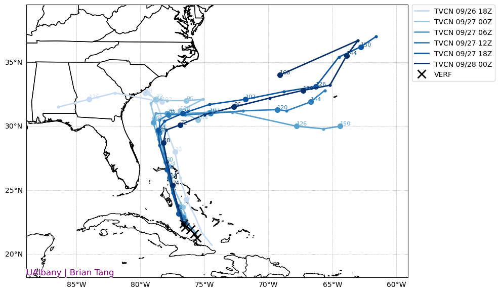
Note the bolded: the slower speed of movement has increased the chance of it staying away from the US: Tropical Depression Nine Discussion Number 6 NWS National Hurricane Center Miami FL AL092025 1100 PM EDT Sat Sep 27 2025 The depression this evening remains fairly disorganized, with convection mainly oriented in a north-south fashion with only a hint of banding on the northern side. A NOAA-P3 aircraft that has been flying through the system only found a peak 700 mb flight level wind of 34 kt about 60 n mi away from the center. Tail Doppler Radar (TDR) analysis from the aircraft also shows the center is quite broad at the 1 km level with the mid-level center tilted to the south with height. Based on the plane data, the initial intensity remains 30 kt this advisory, which is a little under the various satellite-based estimates, but close to a recently received scatterometer pass which had a peak wind of 31 kt. Aircraft fixes both at 700 mb and from the TDR analysis shows the cyclone is meandering right now, with a best guess at a motion of 310/2 kt. Over the next couple of days, the system should turn north-northwestward with a somewhat faster forward motion, moving within the flow between an upper trough over the southeast U.S. and a subtropical ridge over the Atlantic. This forecast brings the depression over the central and northwestern Bahamas through early Monday, then toward the southeast U.S. coast by Tuesday. It is notable to point out the system has been moving slower than anticipated over the last 12-24 hours, and this could have significant implications on its ultimate track. Even in the first 48 hours of the track, there is quite a bit of spread in the north-south direction in both the deterministic and ensemble model guidance. Faster tracks appear to interact more with the upper-level trough to the west, resulting in a track closer to the Carolina coastline, while slower tracks largely miss a direct interaction with this feature, and turn sharply east faster as Hurricane Humberto approaches from the east, eroding the mid-level ridging steering TD9 northward. Because it has been moving slower than expected, its becoming more likely its ultimate track will fall in the slower and sharper east camp. In response, the overall track guidance this cycle shifted slower and further east, and the NHC track forecast was shifted in that direction. The latest track roughly splits the difference between the ECMWF and GFS tracks, and lies quite close to the HCCA consensus aid, but still not as far south and east as the Google DeepMind ensemble mean (GDMI). The depression is now showing signs of intensification yet, with a broad diffuse structure on aircraft observations persisting. However, the intensity guidance is insistent that deep central convection will soon form near the center, helping to tighten up the surface wind field. While the cyclone will have some southerly shear to deal with, it does not appear to be prohibitively strong, only 15-20 kt for the next 48 hours in both the GFS and ECMWF-based SHIPS guidance. That, combined with warm 29-30 C sea-surface temperatures should promote steady intensification once a central core develops, and the NHC intensity forecast was nudged up a little higher showing a 70 kt peak in 48 hours. After this period is where the intensity forecast gets tricky. The large spread in north-south tracks also has a significant impact on the amount of shear the system will face in the 48-96 hour time-frame. Solutions that are further south have less shear to contend with and are generally stronger. For now, the latest intensity forecast will cap the peak intensity at 70 kt through the end of the forecast, close to the HCCA intensity guidance, but this could be conservative if the track shifts further south and east. The system could also interact with a baroclinic zone towards the end of the forecast, but because the forecast track remains over warm waters at day 5, extratropical transition won't be shown quite yet. Even if this further offshore track pans out, the wind field is expected to expand quite a bit, and given the expected storm structure, a risk of significant heavy rainfall, storm surge, and wind impacts is still possible for the southeast U.S. coast even if the storm center remains offshore. KEY MESSAGES: 1. The depression is expected to strengthen and bring tropical storm conditions to portions of the central and northwestern Bahamas through Sunday night. Tropical storm conditions are also possible along portions of the east coast of central Florida beginning Monday, where a Tropical Storm Watch is in effect. 2. Rainfall will continue to impact eastern Cuba and the Bahamas through the weekend, which will likely produce flash and urban flooding. Mudslides are possible in the higher terrain. 3. There is a significant threat of heavy rainfall early next week from portions of the east coast of Florida northward into the Carolinas, which could cause flash, urban, and river flooding. 4. The depression is expected to be at or near hurricane intensity when it is closest to the southeast U.S. coast early next week, where there is a risk of storm surge and wind impacts. Although it is too soon to specify the exact location and magnitude of impacts, residents should closely monitor the latest forecast updates and ensure that they have their hurricane plan in place. FORECAST POSITIONS AND MAX WINDS INIT 28/0300Z 22.4N 76.7W 30 KT 35 MPH 12H 28/1200Z 23.6N 77.0W 35 KT 40 MPH 24H 29/0000Z 25.5N 77.5W 50 KT 60 MPH 36H 29/1200Z 27.3N 77.9W 60 KT 70 MPH 48H 30/0000Z 28.7N 78.2W 70 KT 80 MPH 60H 30/1200Z 29.9N 78.1W 70 KT 80 MPH 72H 01/0000Z 30.4N 77.3W 70 KT 80 MPH 96H 02/0000Z 31.0N 75.0W 70 KT 80 MPH 120H 03/0000Z 31.5N 71.4W 70 KT 80 MPH $$ Forecaster Papin
-
Hardly moving! BULLETIN Tropical Depression Nine Advisory Number 6 NWS National Hurricane Center Miami FL AL092025 1100 PM EDT Sat Sep 27 2025 ...DEPRESSION MEANDERING TO THE SOUTH OF THE CENTRAL BAHAMAS... ...HEAVY RAINS EXPECTED TO CONTINUE OVER PARTS OF EASTERN CUBA AND THE BAHAMAS OVER THE NEXT DAY... SUMMARY OF 1100 PM EDT...0300 UTC...INFORMATION ----------------------------------------------- LOCATION...22.4N 76.7W ABOUT 220 MI...355 KM NW OF THE EASTERN TIP OF CUBA ABOUT 100 MI...160 KM SW OF THE CENTRAL BAHAMAS MAXIMUM SUSTAINED WINDS...35 MPH...55 KM/H PRESENT MOVEMENT...NW OR 310 DEGREES AT 2 MPH...4 KM/H MINIMUM CENTRAL PRESSURE...1004 MB...29.65 INCHES
-
Thanks, interesting.
-
Or, enable everything but the euro stuff to see all the Google ideas, by going to menu button https://deepmind.google.com/science/weatherlab
-
https://www.weathernerds.org/models/genc.html
-
For entertainment, I highly suggest gong and watching what the nam 12k does with the 2 storms. Wild what it does.
-
Link?
-
Just saw the 18z Google ensembles there looks to be about 6 or more runs that hang back and go up the east coast towards the north east... The 18z Google models shifted west for the up the coast ones 12z had a lot going to cape cod. Majority go east, however, majority now go, north north east versus nearly due east.
-

Category Five Hurricane Humberto
WxWatcher007 replied to WxWatcher007's topic in Tropical Headquarters
Hurricane Humberto Discussion Number 14 NWS National Hurricane Center Miami FL AL082025 1100 PM AST Sat Sep 27 2025 Humberto remains a large, powerful hurricane this evening, with a spectacular satellite presentation. The hurricane has a clear, 19C, symmetric 25 nm wide eye that is surrounded by a white ring of very, cold (-73C) cloud tops. The most intense deep convection associated with the eyewall appears to be just east of the surface center, where -78C (CMG) tops are discernible. Impressive ventilation aloft is provided by dual outflow channels located over the north semicircle of the cyclone. The latest subjective Dvorak data-T numbers from TAFB and SAB, and the various UW-CIMSS objective estimates support holding the initial intensity at 140 kt. Humberto could undergo inner core structural changes, which will likely cause intensity fluctuations during the next 12-24 hours. In fact, an earlier GPM/GMI overpass revealed a hint of concentric outer ring development, and the UW-CIMSS MPERC is indicating up to a 78hance of another ERC event. Afterward, the statistical and skilled consensus intensity models point toward a gradual weakening trend beginning around Monday. Through the remaining period, further weakening at a faster pace is expected while the cyclone becomes embedded in the strong upper-level westerly flow. By the 60 hour period, Humberto should continue moving around the southwestern periphery of a mid-tropospheric ridge located to the northeast of the cyclone and east of Bermuda. By Tuesday night, Humberto is forecast to turn north-northeastward while the ridge mentioned above weakens and shifts eastward. By mid-next week, Humberto should turn quickly toward the northeast to east-northeast in response to a major shortwave upper-level trough amplifying and moving out of the Canadian Maritimes and into the northwestern Atlantic waters. There remains quite a bit of along-track spread beyond day 4, which is typically seen when tropical cyclones move within the mid-latitude upper-westerlies and commence a structural transition to an extra-tropical cyclone. The NHC forecast is nudged toward the TVCA simple consensus and the HCCA corrected aid, and is close to the previous advisory. FORECAST POSITIONS AND MAX WINDS INIT 28/0300Z 23.4N 62.1W 140 KT 160 MPH 12H 28/1200Z 24.1N 63.5W 140 KT 160 MPH 24H 29/0000Z 25.4N 65.3W 135 KT 155 MPH 36H 29/1200Z 27.1N 66.9W 130 KT 150 MPH 48H 30/0000Z 29.1N 68.1W 120 KT 140 MPH 60H 30/1200Z 30.9N 68.7W 110 KT 125 MPH 72H 01/0000Z 33.2N 67.8W 100 KT 115 MPH 96H 02/0000Z 37.0N 58.7W 95 KT 110 MPH 120H 03/0000Z 44.7N 41.4W 85 KT 100 MPH...POST-TROP/EXTRATROP $$ Forecaster Roberts -

E PA/NJ/DE Autumn 2025 Obs/Discussion
Albedoman replied to PhiEaglesfan712's topic in Philadelphia Region
sorry, I was not living here in PA at the time so I never experienced what was going on. I was down in Memphis Tn at the time. I had other hurricanes to deal with down there at the time Elena but more importantly, Memphis had over a foot of snow in one storm in the winter of 85 . That would be like a 3 ft snow here. -

September 2025 OBS-Discussion centered NYC subforum
winterwarlock replied to wdrag's topic in New York City Metro
81/67/82 -
If the ai models pan out, the entire east coast needs to be on alert from Carolinas to the north east.....
- Today
-
I feel like it’s going to be a short Fall for me here. 80’s this weekend and start of the week to 60’s by the end. Of course I’m jonesing for the cooler weather but every long time Montanan is trying to soak up the warmth as much as possible lol. The feeling around town is a normal Winter is coming vs what’s happened the past few years.
-
lol. The fact that I was able to bike in this says a lot, though it was actually kind of a pleasant light rain.
-
0.86" I am now whelmed
-

Central PA Fall Discussions and Obs
Itstrainingtime replied to ChescoWx's topic in Upstate New York/Pennsylvania
It sure was. An absolute dime. -

Central PA Fall Discussions and Obs
WxUSAF replied to ChescoWx's topic in Upstate New York/Pennsylvania
Ok that was a good throw -
Central PA Fall Discussions and Obs
Itstrainingtime replied to ChescoWx's topic in Upstate New York/Pennsylvania
I was his biggest supporter until the last few games of last year. I was wrong. -
The rain was prominent today in the eastern valley. It developed there and redeveloped a couple of times. I went through a heavy rain shower with lightning aplenty in West knox around 8:45.


