All Activity
- Past hour
-

2025 Atlantic Hurricane Season
BarryStantonGBP replied to BarryStantonGBP's topic in Tropical Headquarters
I wonder if this means ironically if hurricane formation would be more favourable in 2025 than last year -

September 2025 OBS-Discussion centered NYC subforum
donsutherland1 replied to wdrag's topic in New York City Metro
As of 4 pm, Central Park had a high of 68°. Should Central Park have a high of 69° or below, it would be the first time New York City has seen a high in the 60s during the first week of September since September 6, 2019 when the mercury topped out at 67°. Yesterday, Central Park received 1.01" of rain, its first 1.00" or above daily rainfall since July 14. Additional rain fell today. Two-day rainfall amounts across the region included: Islip: 0.77" New Haven: 1.39" New York City-Central Park: 1.64" New York City-JFK Airport: 0.99" New York City-LaGuardia Airport: 1.56" Newark: 0.89" White Plains: 1.56" Temperatures will mainly top out in the 70s during the daytime and fall into the 50s at nighttime in New York City through at least Wednesday. Thursday could be briefly warmer with highs in the upper 70s to perhaps lower 80s. Additional showers or rain is possible on Thursday, as another cold front crosses the region. The ENSO Region 1+2 anomaly was -0.3°C and the Region 3.4 anomaly was -0.4°C for the week centered around August 27. For the past six weeks, the ENSO Region 1+2 anomaly has averaged +0.33°C and the ENSO Region 3.4 anomaly has averaged -0.32°C. La Niña conditions will likely develop during mid- or late-autumn. The SOI was +6.95 today. The preliminary Arctic Oscillation (AO) was -0.932 today. Based on sensitivity analysis applied to the latest guidance, there is an implied near 59% probability that New York City will have a cooler than normal September (1991-2020 normal). September will likely finish with a mean temperature near 68.2° (1.0° below normal). Supplemental Information: The projected mean would be 0.2° above the 1981-2010 normal monthly value. -

September 2025 OBS-Discussion centered NYC subforum
Picard replied to wdrag's topic in New York City Metro
I'm half that at 1.20 for the month. We only got 0.08" out of everything yesterday and this morning. What I have noticed lately is the stubborn banding and pretty sharp cutoffs. In that wherever the banding starts to set up, that's who's getting it, and it's not wavering much. Things always seem to train northeast over the same spots. I'd love to see a study of summer thunderstorm precipitation patterns in this area because it always seems to be two distinct areas. The most common is over the Delaware Water Gap and places to the north and west, and the other, not as frequent area is to the south and east, starting well south of Philly and training up and eventually off shore towards Long Island. The drought monitor shows this, and I'll be curious to see how it changes next week. Perhaps just a short term blip, or something longer term due to climate and topography. But it's definately a thing. -
September 2025 OBS-Discussion centered NYC subforum
donsutherland1 replied to wdrag's topic in New York City Metro
Years with one or more 90° temperatures on or after the fall equinox for select New York City Area locations: Bridgeport: 1970 Islip: 1980 New York City-Central Park: 1881, 1895, 1914, 1927, 1933, 1938, 1939, 1941, 1959, 1961, 1970, 1980, 2017, 2019 New York City-JFK Airport: 1970, 1980, 2007, 2017, 2019 New York City-LaGuardia Airport: 1941, 1946, 1970, 1980, 1998, 2007, 2010, 2017, 2019 Newark: 1881, 1895, 1908, 1914, 1938, 1939, 1941, 1949, 1958, 1959, 1961, 1968, 1970, 1980, 1998, 2007, 2010, 2016, 2017, 2019 White Plains: 1970, 2017, 2019 -
Giants wont be sticking with Wilson as the starter very long lol.
-

September 2025 OBS-Discussion centered NYC subforum
Roger Smith replied to wdrag's topic in New York City Metro
At least 14 years have had a 90F or higher reading in astronomical autumn (not a precise measure but I counted only cases from Sep 21 onward). These fourteen qualified, I will do a deeper search and edit this if I find any hidden ones. Those with an asterisk did not set a daily record or did not maintain it to present day. A few of these years (1895, 1914, 1941, 1970) had several days above 90. There were also 89s in 1922, 1926, 1949, 1958, 1959, 1986, 1998 and 2010. 1881 1895 1914 1927 * 1931 * 1933 1938 1939 1940 * 1941 1970 1980 * 2017 2019 In these fourteen years there were at least 25 days with 90+ readings and the average of all of them was 92. The highest was 97 (23rd 1895). So never say never to 90F. * to be clear about 1927, it holds a record of 88F for Oct 1st but lost its 90F record for the 2nd to 2019. The others marked (1931, 1940, 1980) were not records when they happened, as they were in the 1895-1914 era. Most of the 89F readings are not records either, the 1986 one is (Sep 30th). It was 88F as late as Oct 22nd 1979. That date also had the record high min of 67F in 1979. This was probably the latest calendar date to match modern normal temperatures in July (Nov 1-2 1950 were close). -

September 2025 OBS-Discussion centered NYC subforum
Sundog replied to wdrag's topic in New York City Metro
If we're talking about Central Park, then maybe. They struggle to hit 90 in July let alone mid to late September. -
Nice Commanders win today
-

September 2025 OBS-Discussion centered NYC subforum
FPizz replied to wdrag's topic in New York City Metro
Philly runs way high too, cheap 90. Only a handful made 90 overall. Only made it to 85 here with rain moving in early -

September 2025 OBS-Discussion centered NYC subforum
nycwinter replied to wdrag's topic in New York City Metro
summer is over nyc will not hit 90 again until next year! -
When I was a kid growing up, we were lucky if even the next few days forecast was correct. The computer models were really primitive during the 70s and 80s. But the Euro doing so well with March 93 and January 96 events began to give us some confidence in the 3-5 day forecast. Occasionally the model does really well on storm details day 6-10 like with Sandy. But the range beyond week 1 and week 2 is still very low skill. Maybe they can find a way for AI to bias correct the longer range NWP forecasts.
-

2025-2026 ENSO
40/70 Benchmark replied to 40/70 Benchmark's topic in Weather Forecasting and Discussion
Yea, I'm not arguing any of that...but temps and 500mb heights are kind of a big deal. I mean, I nailed snowfall last season...but I was too warm....that can't be ignored. -
Yeah, looking some better out there. NATL looking better as well.
- Today
-
Aaaaand the Steelers win. Jets played well overall and should have won.
-
Stopped raining hours ago . Stick to chopping wood
-
If we are looking for as close to perfection as we can get from an October seasonal forecast, then the JMA October 2013 record TNH forecast was pretty close. https://ds.data.jma.go.jp/wmc/products/model/map/7mE/map1/pztmap.php
-
LOL Brandon Stephens. Awkwardly dropped a would be interception that might have sealed it for the Jets. Then a typical PI call where he had zero awareness of where the ball was to help the Steelers on this drive that will probably win the game for them. Enjoy Jets fans!
-

E PA/NJ/DE Autumn 2025 Obs/Discussion
JTA66 replied to PhiEaglesfan712's topic in Philadelphia Region
Finished with .90”. Grass and mosquitoes are happy. -
.66 of rain last 24 hours, can't complain. Some areas over 2.50. Feast or famine.
-
-
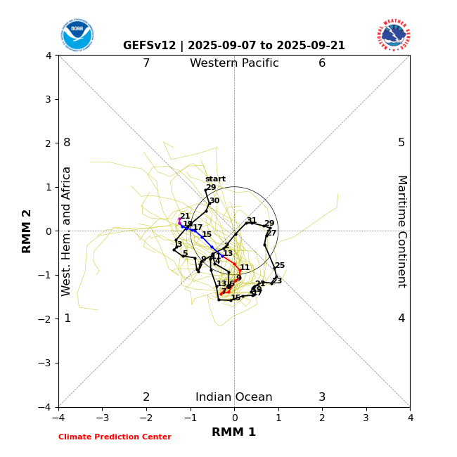
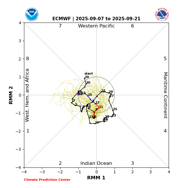
Snowman, the GFS and EPS MJO forecasts (the two best imho) for the next 2 weeks agree that the MJO will remain in the IO and then reverse back to the W Hem/Africa. There’s no MC in sight:
-

September 2025 OBS-Discussion centered NYC subforum
bluewave replied to wdrag's topic in New York City Metro
I know the NYC micronet in Fresh Kills made it to 92° yesterday and Newark was 90° along with Harrison.The next area of 90° highs was spread out from SNJ to CNJ. Fresh Kills 92 67 Climatological Data for HARRISON, NJ - September 2025 Click column heading to sort ascending, click again to sort descending. 2025-09-01 80 61 70.5 -2.9 0 6 0.00 0.0 0 2025-09-02 80 60 70.0 -3.1 0 5 0.00 0.0 0 2025-09-03 79 58 68.5 -4.4 0 4 0.00 0.0 0 2025-09-04 81 62 71.5 -1.1 0 7 0.00 0.0 0 2025-09-05 80 65 72.5 0.1 0 8 0.89 0.0 0 2025-09-06 86 67 76.5 4.4 0 12 0.00 0.0 0 2025-09-07 90 61 75.5 3.7 0 11 1.29 0.0 -
Low of 70, high of 89. Clouded over and hearing some distant thunder. Not much on radar right now but it is supposed to pick up soon. Getting very dry out there. We definitely need the rain.
-
MU talkin' drought today. Extended looking very dry.
-
Ray, I graded the Sept ‘24 Euro 2M temp. forecast for DJF 2024-5 an F, the worst Sept winter forecast going back at least to that of Sept of 2017, the furthest back I can find. The Euro averaged ~4F too warm for most of the US! The only area it did well with was the SW. The Sept ‘20 Euro forecast for 20-21 was similarly too warm but not by quite as much (avg of ~3F too warm for the US). OTOH, the Sept forecast for 2023-4 was pretty bad in the other direction with an average miss of ~3F too cold for the US overall. The last good Sept Euro 2M forecasts for the lower 48 as a whole were for 2021-2 and 2019-20. The avg miss in the NE was very small.