All Activity
- Past hour
-
.thumb.jpg.6a4895b2a43f87359e4e7d04a6fa0d14.jpg)
Central PA Winter 25/26 Discussion and Obs
Yardstickgozinya replied to MAG5035's topic in Upstate New York/Pennsylvania
Hopefully things start to blossom, that radar's looking wiggetty wiggetty wack at the moment. -

Pittsburgh/Western PA WINTER ‘25/‘26
blackngoldrules replied to Burghblizz's topic in Upstate New York/Pennsylvania
Moderate to heavy snow right now. Radar filled in nicely for us. Sent from my SM-S931U using Tapatalk -
Wantage NJ 4sw: 0.4" 240AM intermim report. Everything covered 23.5F. Walt 1/17/26
-

First Legit Storm Potential of the Season Upon Us
ineedsnow replied to 40/70 Benchmark's topic in New England
Still going a bit after this.. looks like the RAP.thumb.png.7218d3a3b82f91ac7abd48e0c7210bee.png)
-
First Legit Storm Potential of the Season Upon Us
ineedsnow replied to 40/70 Benchmark's topic in New England
Legit snowstorm for all of SNE.. We pray its right -
And SREF
-
First Legit Storm Potential of the Season Upon Us
ineedsnow replied to 40/70 Benchmark's topic in New England
-
First Legit Storm Potential of the Season Upon Us
ineedsnow replied to 40/70 Benchmark's topic in New England
HRRR way west of 0z -
First Legit Storm Potential of the Season Upon Us
ineedsnow replied to 40/70 Benchmark's topic in New England
AI FTW? -
First Legit Storm Potential of the Season Upon Us
ineedsnow replied to 40/70 Benchmark's topic in New England
6z HRRR trying to join the party -
New SREF mean vs 21z. Never been that impressed with the SREF but interesting nonetheless. Old New
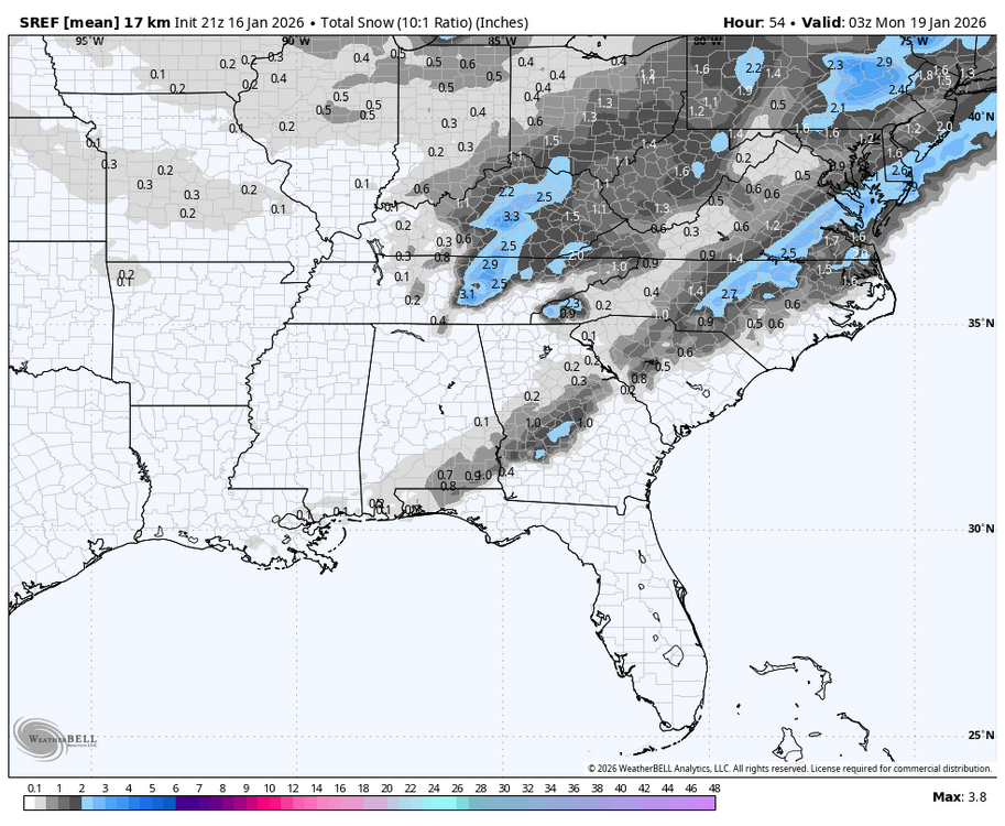
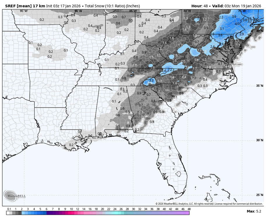
-
All snow here now but not as heavy as Shocker is seeing.
-
Special Weather Statement...UPDATED National Weather Service Morristown TN 154 AM EST Sat Jan 17 2026 TNZ012>018-041-043>047-072-074-087-VAZ001-002-005-006-008-171500- Scott TN-Campbell-Claiborne-Hancock-Hawkins-Sullivan-Johnson- Cocke Smoky Mountains-Southeast Greene-Washington TN-Unicoi- Northwest Carter-Southeast Carter-Blount Smoky Mountains- Sevier Smoky Mountains-Southeast Monroe-Lee-Wise-Scott VA-Russell- Washington VA- Including the cities of Big South Fork National, Oneida, Smokey Junction, Elgin, Huntsville, Norma, Slick Rock, Fincastle, La Follette, Elk Valley, Jellico, White Oak, Caryville, Royal Blue, Lone Mountain, Sandlick, Springdale, Arthur, Harrogate-Shawanee, Clairfield, Howard Quarter, Evanston, Sneedville, Treadway, Kyles Ford, Mooresburg, Kingsport, Bristol TN, South Holston Dam, Doeville, Mountain City, Neva, Shady Valley, Trade, Laurel Bloomery, Hartford, Cedar Creek, Johnson City, Erwin, Unicoi, Limestone Cove, Elizabethton, Hampton, Cades Cove, Elkmont, Gatlinburg, Citico, Coker Creek, Rose Hill, Big Stone Gap, Norton, Wise, Coeburn, Appalachia, Pardee, Hiltons, Hansonville, Lebanon, Dye, Castlewood, Honaker, Rosedale, Benhams, Bristol VA, and Abingdon 154 AM EST Sat Jan 17 2026 ...Light Snow Accumulations Possible Saturday Morning... Periods of light to moderate snow showers will lead to a quick 1 to 2 inches of accumulation in some locations Saturday morning. The most likely locations to receive snow accumulation will be elevations above 2000 feet. Highest mountain peaks could see isolated totals near 3 inches. A dusting up to one inch will be possible in lower elevations of southwest Virginia and northeast Tennessee. Any accumulations of snow are expected to be light. However, driving and walking may be difficult on some untreated roadways and sidewalks. Be prepared for slippery roads and limited visibilities. If traveling, slow down and allow extra time to reach your destination. $$
-
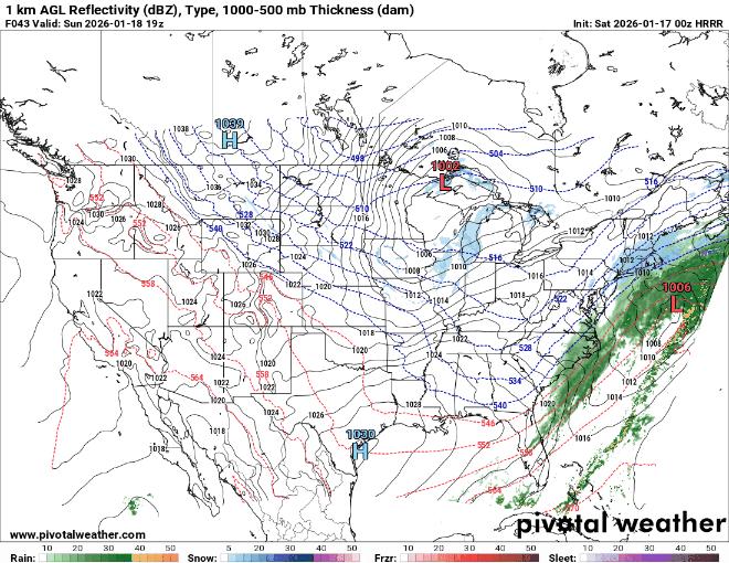
First Legit Storm Potential of the Season Upon Us
ineedsnow replied to 40/70 Benchmark's topic in New England
EPS came west a bit -
Good dusting here between Crossville and Monterey. Big flakes the whole time. It switched to snow just after midnight central here
-
-

Mid-Long Range Discussion 2026
WinstonSalemArlington replied to BooneWX's topic in Southeastern States
-

Pittsburgh/Western PA WINTER ‘25/‘26
MikeB_01 replied to Burghblizz's topic in Upstate New York/Pennsylvania
Doesn’t look like much on the radar right now, but it’s a snow globe in bethel right now . - Today
-
Well that's interesting because Feb 1934 was super cold in eastern N. America. (so was Dec 1933, Jan 1934 was closer to average)
-

First Legit Storm Potential of the Season Upon Us
Roger Smith replied to 40/70 Benchmark's topic in New England
Maybe Charlie Brown WILL kick a field goal after all. And if so, nobody else will !!! -
It's finally started reaching the ground here, it's now 35 with rain and snow mixed. Crazy how long it took to start reaching the ground here.
-
Storm potential January 17th-18th
Roger Smith replied to WeatherGeek2025's topic in New York City Metro
I think the GFS is improving, they are now cancelling snowstorms shown on day 12 by day 10. -
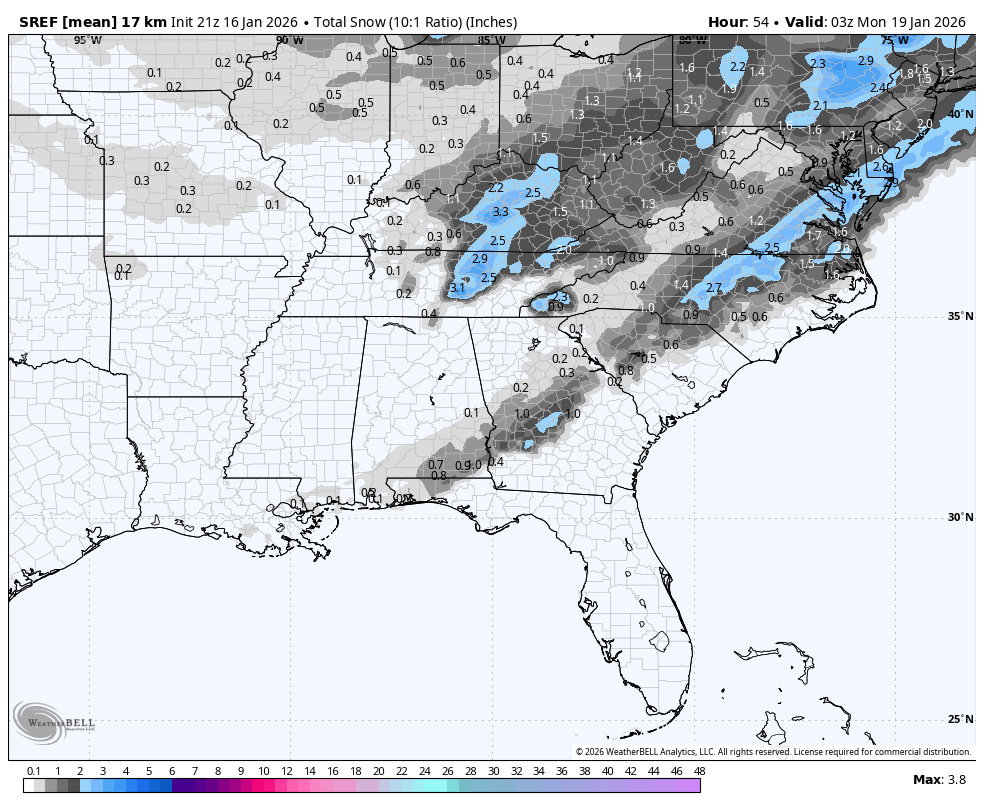
Mid-Long Range Discussion 2026
WinstonSalemArlington replied to BooneWX's topic in Southeastern States
SREF -
40F at DCA now, 37.6F here in NW DC.
-

First Legit Storm Potential of the Season Upon Us
8611Blizz replied to 40/70 Benchmark's topic in New England
The local mets are going to pull their hair out before this one is done.

.png.4b6babd08c9348c6b28a367e187c3cb6.png)