All Activity
- Past hour
-
I taught you all about winter wx.
-
Will be not much more than .25”
-

Central PA Spring 2026 Discussion/Obs Thread
mahantango#1 replied to Voyager's topic in Upstate New York/Pennsylvania
.33 rain today, was more than I was expecting. -
Central PA Spring 2026 Discussion/Obs Thread
mahantango#1 replied to Voyager's topic in Upstate New York/Pennsylvania
I wonder what the upcoming winter will bring? Knowing our luck maybe several freezing rain events. -
Yea, the pump back operation is pretty interesting. Our property at Leesville lake is near the head of the lake so it's pretty cool when they let it loose. I've kayaked the "surge" from the visitor center to our ramp area. Its not rough or whitewater or anything like that but you move down stream pretty quick lol. The double lake pump back operation is 1 of only 2 in the world. They release during peak demand and pump back during low demand when rates are lower. Free money glitch for the power company lol. Leesville lake can go up and down as much as 10' a day. I've been fishing from shore during big releases and you get chased uphill haha. Leesville is 3.5k acres and smith is over 20k. A full 10' pump back can only raise Smith 1' though so they can't balance the levels in that direction. Smith has an annual draw down in the fall/winter after peak boating season but it's usually short lived. Like a few weeks. We haven't had full pool since last summer and having it so low during peak season is tickin' a lot of people off. No quick fix this time. It's going to take a lot of rain to get back to full pool. Record low is 788.30 looking at the levels data but it happened in 1977 and not 1968 like the news said. I should call and correct them haha
-
I’m so frustrated with the start of this golf season. I’ve played every Saturday (40 degrees and rain/wind). The two non-Saturday rounds I’ve played have been 30+ mph winds. Like my scores are bad as a result and it’s mentally crushing me.
-
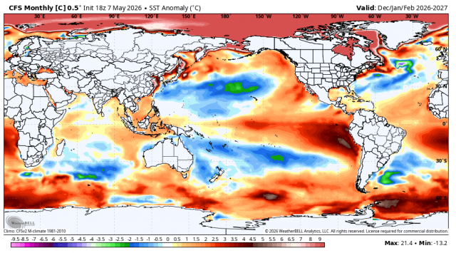
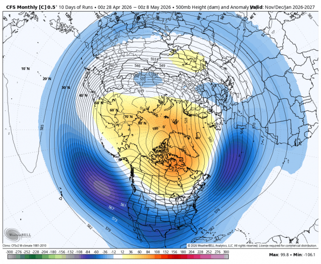
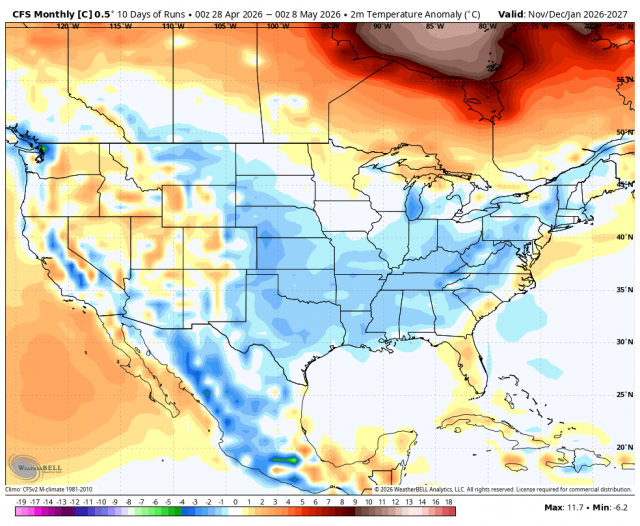
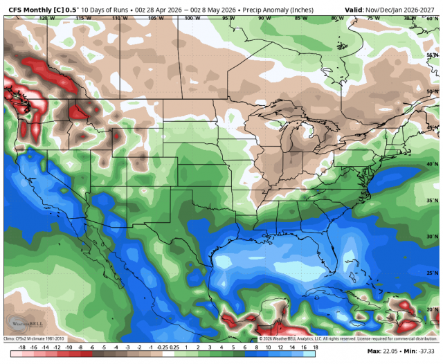
With the rain fizzling out this week (again); thought I'd share some maps from WB JB. WB CFSv2 (control) that even he acknowledges may be wishful thinking for the upcoming winter. If only.... Will keep these maps. If I am understanding him correctly, JB thinks cooler water off Australia is critical for our chances of any East coast cold air this winter. I will be watching that factor.
-
Had a nice line run through while I was dropping the family off at the outlets in Deer Park. It was absolutely pouring for about 5 minutes on the way back to the house. Luckily, they got into the theater before it started. Beautiful early evening sun, might get a quick dog walk in.
-
Big rain.
-
Did they seem generous with credits or did you have to keep upgrading?
-
I think it's very good. Haven't played around with it much. Can you link to thredex data?
-
there are more than enough smart and willing people that can code/compile/edit an app that simple, and inexpensively
- Today
-
Waiting for those storms the NAM has been promising me for (checks time), right now
-
Meh...it's all good. I was just annoyed in the moment because I thought I was responding to weatherwiz through you're post when it was directed at Scott... whatever. ha
-
.11" bust. Sunny now
-
CoastalWx is the absolute king of post #'s on this group, and he is among the most vocal causal complainers, never mind one-liners when he is weenie'ing out (e.g. WE SNOW), and we have coined "ACATT," so why not? Point reference where all other weenies are rated! After working w/ him for more than 10 years and seeing him in action as a weenie, he lives for jabs and debate! My favorite line from him was pointing out caveats to an upcoming snowstorm, and he would always go, "We'll see!" Reassuring confirmation bias to make himself feel better and hoping the snow would turn as out as he wanted (wished) it!
-
We knew
-
I thought people would like it but haven't had much feedback other then the troll putting laugh emojis Any suggestions appreciated
-
-

2026-2027 Strong/Super El Nino
snowman19 replied to Stormchaserchuck1's topic in Weather Forecasting and Discussion
1911-12 and 1914-15 were super El Ninos? Edit: Nevermind, just saw @GaWx post about 1977-78, they were all weak to low-end moderate Ninos -
This is impressive...the back edge of this denser mid/ua cloud shield which is entering western MA/CT as I type, was over the IN/OH border at dawn this morning... That's a fast flow wow.
-
After some additional rain and showers tonight into early tomorrow, tomorrow will turn noticeably warmer under variably cloudy skies. Highs will likely top out in the middle 70s. Some additional showers and a thundershower are possible late tomorrow and tomorrow night. Nevertheless, the first 10 days of May will likely see temperatures average cooler than normal normal overall. Much of next week will see temperatures top out in the lower and middle 60s. Additional showers are possible Thursday and Friday as a frontal boundary stalls near the region. Warmer air could arrive during the weekend. In the long-range, there has been a shift in the guidance toward a near or somewhat warmer than normal second half of May. The probability of a warmer than normal second half of May has increased. The ENSO Region 1+2 anomaly was +1.3°C and the Region 3.4 anomaly was +0.9°C for the week centered around April 29. For the past six weeks, the ENSO Region 1+2 anomaly has averaged +1.47°C and the ENSO Region 3.4 anomaly has averaged +0.42°C. El Niño conditions will likely develop during late spring or early summer. The SOI was +6.07 today. The preliminary Arctic Oscillation (AO) was -0.659 today. Based on sensitivity analysis applied to the latest guidance, there is an implied near 54% probability that New York City will have a cooler than normal May (1991-2020 normal). May will likely finish with a mean temperature near 62.5° (0.7° below normal). Supplemental Information: The projected mean would be 0.1° above the 1981-2010 normal monthly value.
-
Overperformer out here. Up to 0.93” with more to come. Wasn’t expecting an inch plus
-
Steady rain now. Let’s wet the lawn.


.thumb.gif.f92b16c631a1d15d405ed77b33f0710d.gif)


