All Activity
- Past hour
-
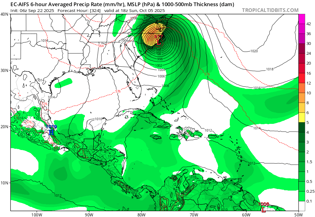
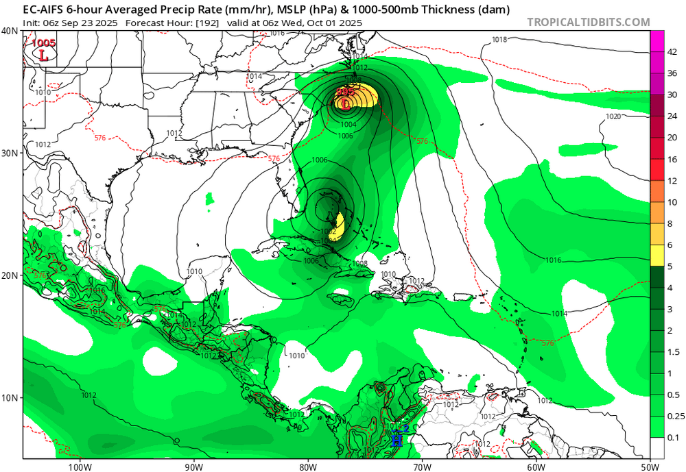
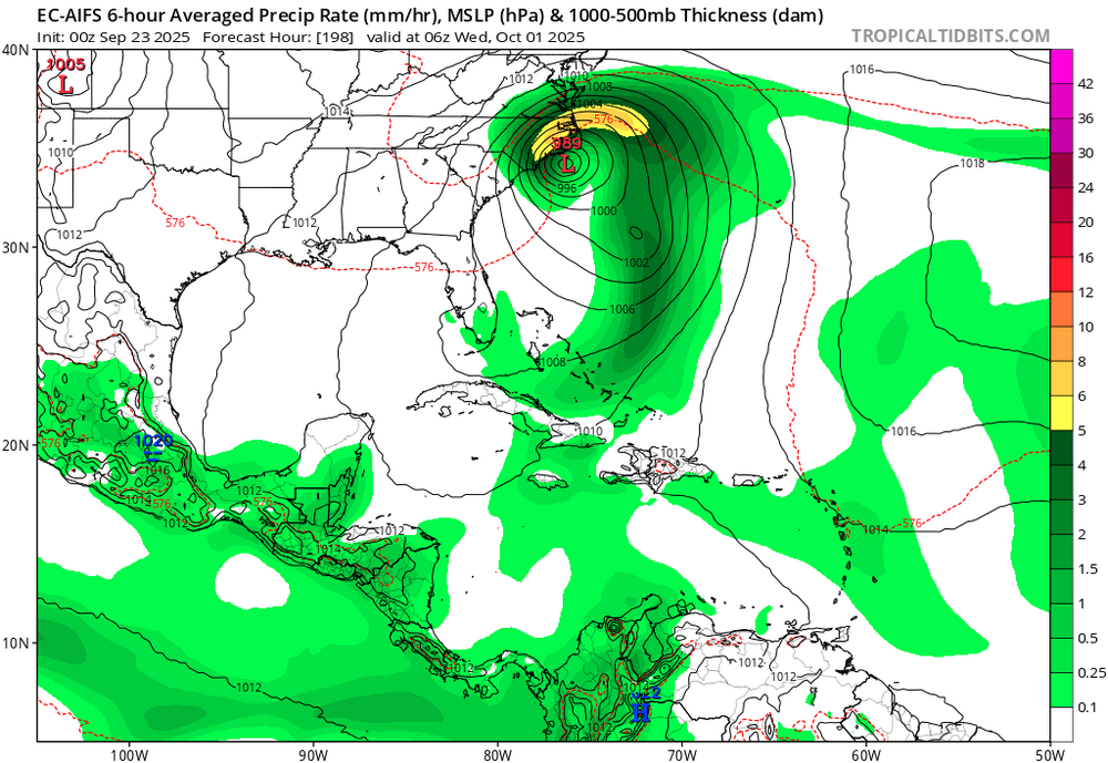
Pumpkin: 12Z UKMET dropped the FL TC but still has this though it doesn’t form til 162, moving WNW to the SSW of Bermuda: NEW TROPICAL CYCLONE FORECAST TO DEVELOP AFTER 162 HOURS FORECAST POSITION AT T+162 : 22.7N 67.7W LEAD CENTRAL MAXIMUM WIND VERIFYING TIME TIME POSITION PRESSURE (MB) SPEED (KNOTS) -------------- ---- -------- ------------- ------------- 1200UTC 11.10.2025 168 23.0N 68.5W 1009 24
-
Humans normalizing CC is exactly why we're all screwed. We're not far away from catastrophic events affecting our region whether it be extreme drought, hurricanes, California style fires, grid destroying heat in the summer and so forth. It's not that it's 80+ in October but rather how consistently warm it is.
-
Had a beautiful cool low of 44 this morning with a current temp of 61.
-
All of them always?
-

Spooky Season (October Disco Thread)
jbenedet replied to Prismshine Productions's topic in New England
Same. My min is 37. The lawn and flowers looks great despite the drought -
We would need a much larger even than that once since the cooling effects only lasted into 1992 and the temperatures now are much warmer than back then. https://www.sciencedirect.com/science/article/abs/pii/S1364682624000154#:~:text=Highlights,may be worse than thought. Conclusions The cooling attributed to the Mt. Pinatubo eruption of 0.5 °C over 18 months in the literature mostly based on climate model predictions is overrated. Despite uncertainties remaining in the determination of the cooling and the duration, accounting for natural variability as described in this work by using a simple and intuitive approach reduces the cooling to up to 0.28 °C, on average 0.2 °C, and the duration is similarly reduced to 13 months. This result is consistent with other empirical
-
91 in msp today. Has to be close to an all time October high
-
it's because the cooler shots are narrow and get smoothed out by timing differences in the ensemble
-
I like how if you forecast BN snow in the I95 corridor and AN out west you will be right like 9/10 times now.
-
Why don’t you take the time to actually read these posts instead of inserting a random rant which has nothing to do with the information that Don and I posted.
-
I've averaged just under 13" the last 3 seasons. It's been several years since I've passed the 20" mark for a season.. Considering my average is almost 30" a season, here's to hoping for a better winter for the NW zones.
-

Spooky Season (October Disco Thread)
SouthCoastMA replied to Prismshine Productions's topic in New England
The lawn hasn't looked better -
I17/18 I had 53" and 20/21 had 51". Its not like where I am is much different than nyc. The difference was probably a band or two really, and it could of easily put NY over 50". Snow is very location dependant. Just because one site didnt reach 50 doesnt mean other didnt close by, and that you can broad brush statements like Bluewave does. Like come on, a vei 7 is needed? Even you know that is absurd. He should win weenie of the year honestly.
-
warmth is relative to normal those mid october temps in midwest are 70's for highs..
-

Spooky Season (October Disco Thread)
Baroclinic Zone replied to Prismshine Productions's topic in New England
Hot out there. -

Spooky Season (October Disco Thread)
CoastalWx replied to Prismshine Productions's topic in New England
Man what a day. Now this is COC. -
Spooky Season (October Disco Thread)
CoastalWx replied to Prismshine Productions's topic in New England
Luckily no frost here. We Growtober. Hopefully Mowvember. -
Spooky Season (October Disco Thread)
jbenedet replied to Prismshine Productions's topic in New England
If it wasn’t obvious yet, those early hard frosts suck when we rebound to weekends like this for another 6 weeks. -
Totally making up from the March through June rains on weekends we had.
-
76 / 55 gorgeous day.
-

Spooky Season (October Disco Thread)
WxWatcher007 replied to Prismshine Productions's topic in New England
Beautiful day -
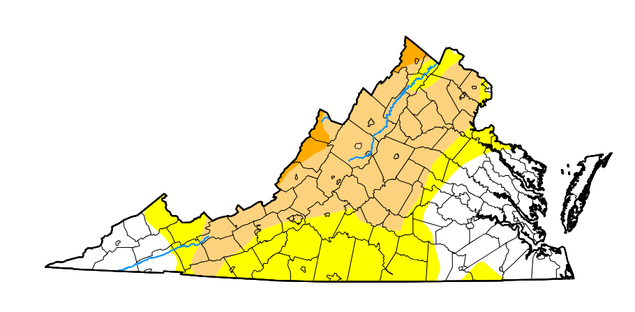
https://droughtmonitor.unl.edu/CurrentMap.aspx
- Today
-
I usually support the idea of warmth overperforming but eps has been terrible at seeing cooldowns the last few months. I seriously doubt the midwest stays that warm for so long.
-
1. Humberto: the vast majority of all models never had it threaten the US 2. Imelda: -No UKMET or Icon had it hit the US and only one JMA did so. They were not only not schooled, they were the schoolers! -Several CMC had it hit as you implied. -A good # of GFS/Euro along with many ens members hit as you implied. -But some Euro AI runs hit, too, including from Humberto. So, UK, Icon, and JMA did better than Euro-AI: this top map has Humberto hit NC!

-
This is far more impressive than those August 91 degree "heat waves"