All Activity
- Past hour
-

2026-2027 Record-breaking El Nino
Keith Central PA replied to Stormchaserchuck1's topic in Weather Forecasting and Discussion
Totally agree. We all try to broadbrush a monthly or seasonal forecasts..Super Nino's,,NAO,PDO ect..saying it will be warm and cold. But it's the daily,actual weather that counts. Back in the 60's and 70's there was a three day forecast. You lived not knowing what was going to happen next week.Maybe that's better. Take life day by day. Hard to do in the world of social media. -
good luck bro
-
Agreed, lots of leaves. I remember one year I stuffed an old pair of jeans with leaves and had the jeans protruding from a bigger pile of leaves next to our walkway. On Halloween night I swapped out those jeans with myself, upper body buried under the leaves. As I was laying there little kids were trick or treating so I just remained still as to not scare them. Then two teenage girls I knew from the neighborhood came up the walkway. I laid still as they walked past to the front door, trying not to laugh as one said to the other "It looks so real!" Then as they walked past me after getting their loot I kicked my leg over onto the walkway and I rose up through the pile of leaves that I was under. They were screaming as they ran away down the street... Low of 38 this morning, 56/34 currently, we'll see about some frost, perhaps a quick freeze, tomorrow morning.
-
Prior models had high pressure over the region shunting any remnants south. The trend has been the opposite lately. AI models also have a solid trough passage in the days after. Could be a signal for a widespread freeze through a good part of the region.
-

2026-2027 Record-breaking El Nino
roardog replied to Stormchaserchuck1's topic in Weather Forecasting and Discussion
I just like interesting weather. For a quarter of the year or maybe even a little more, the only interesting weather around here is winter weather. When your options are a wind driven 35 or 40 degree rain or a wind driven snowstorm, I’ll obviously take the snowstorm every time. The problem around here is that a “warm” winter isn’t warm. It’s not like you’re going to be spending a bunch of outdoors enjoying the weather around here during a “warm” winter unless you like cloudy and windy days in the 30s. -

Invest 92L--90% 2 day, 90% 7 day odds of Development
GaWx replied to WxWatcher007's topic in Tropical Headquarters
I wonder if the GA/AL game in Tuscaloosa on Sat night (7:30PM EDT start) will be heavily impacted by the Gulf tropical cyclone forecasted to form soon. Any guesses? -
Do you think that the GA/AL game in Tuscaloosa on Sat night (7:30PM EDT start) will be heavily impacted?
-
When we lived in Fort Kent, we had slushy flakes during a northeast storm on Sept 14, 1977. Places above 1,000 asl had 2"+. Five years later when we lived near that 1,000 mark in the back settlement, we had slushy flakes on August 28. Had some high 30s gusts 9-10 AM, still pretty windy. About 70% leaf drop and climbing - was a great autumn for colors while it lasted. In another topic, got a couple of deer ticks yesterday, first I've seen since June. The horrid beasts seem to disappear in late summer here.
-

Invest 92L--90% 2 day, 90% 7 day odds of Development
NorthHillsWx replied to WxWatcher007's topic in Tropical Headquarters
Right now, I’d say a strong TS or Cat 1 hurricane impact on the northern gulf coast is looking most likely. Does it peak as higher end intensity in middle of the gulf (most hurricane models)? Does it stay mostly weak (Euro, GFS)? Think the next 24 hours answer those questions but if I was on the northern gulf coast from lake Charles to Panama City I’d probably start planning for strong TS or Low end hurricane impacts being most probable with impacts likely starting late Friday -
Yep. Been trending north.
-
I thought it was going to be south? Recent models change that.
-
Looks like Indewgenous peoples day ruined from that tropical.
-
45 for the low here. Probably low 40s tonight.
-
Yeah we had some cool mornings too, but that first real crisp wind driven cold is what I mean. Just had that feel.
-
Looks like the retirement of the NAMs/HRRR/HREF/etc and operational implementation of the RRFS has been delayed again, this time to November 3. An error was found within one of the ensemble members of the RRFS and was corrected, but I guess per policy they have to wait 30-days
-

2026-2027 Record-breaking El Nino
40/70 Benchmark replied to Stormchaserchuck1's topic in Weather Forecasting and Discussion
I understand why the snowfall tangent in a main ENSO thread can be frustrating for some, and am sorry for that, but the fact is that that a large percentage of weather circles share a common bond; snowfall is what first compelled us to crawl over to the window, and ultimately acted as the catalyst for that nascent interest in weather that has continued to flourish to the extent that it carries us through even our darkest hours today. It's the fountain of youth in that we get to relive that same, youthful and eternally hopeful jubilance that life would have otherwise long since stolen from us...it's that unique lived experience that binds us with the strongest of social fabric, and it's that unique lived experience that drives the autistic inertia that culminates in my drafting of the longest winter outlook known to man each fall , despite having two jobs and 4 children under the ago of 7. Hope that answers your question, there, spoony-fork. -
i see your two stations on Davis map lol.
-
 https://dutashielddirect.com/# how to get avodart no prescription
 -
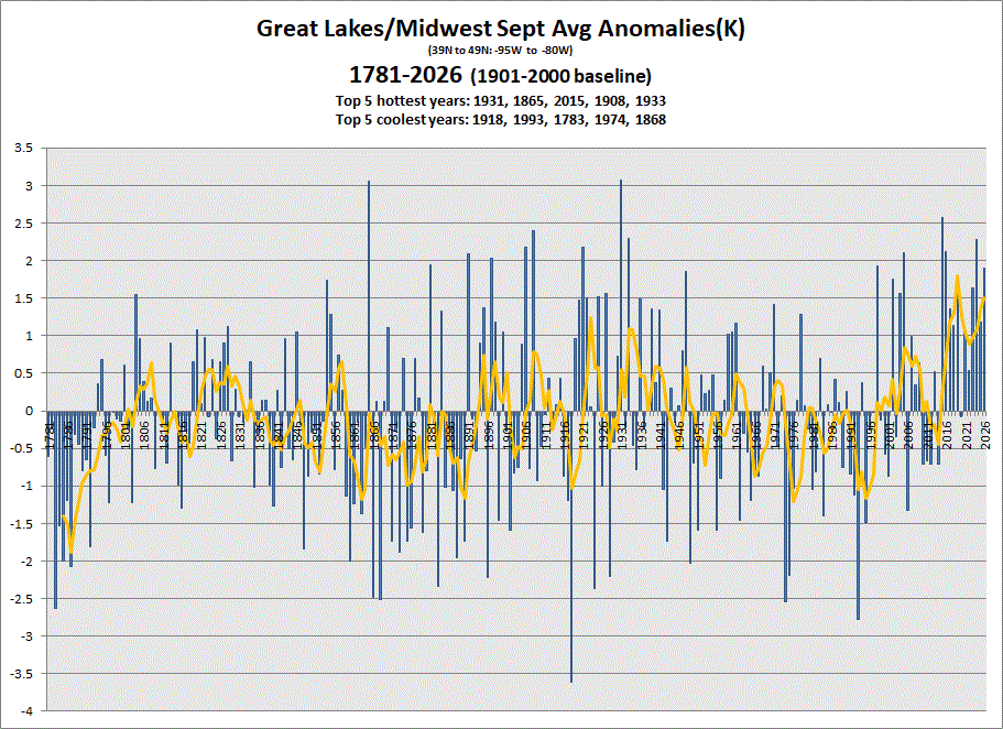
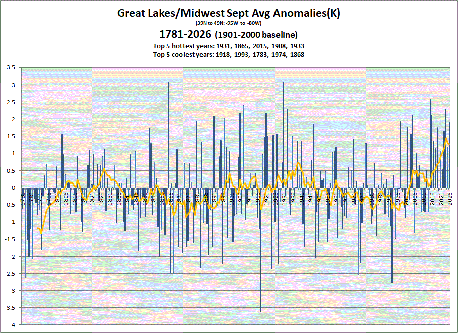
Early data in for Sept. Chalk up another warm one. 5 & 10 yr trend charts shown respectively.
-
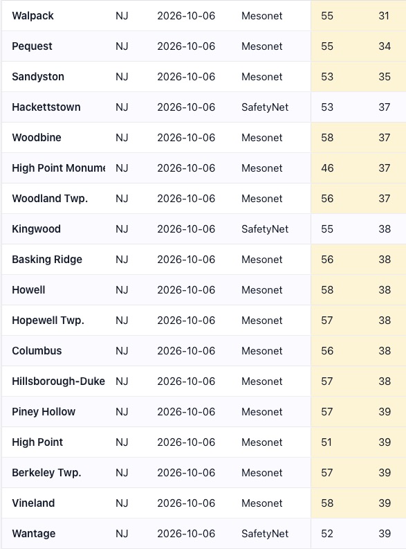
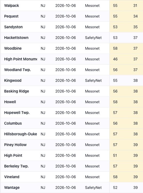
Dipped to 31 in Walpack overnight. Lots of upper 30's around the state in spots that radiate well. Even as far south as Vineland in far south Jersey. Temperatures per NJ WXNET. Overnight low here was 42 on the top of the hill.
-
For Saturday the SPC highlights the coastal boundary moving north. Should be all kinds of shear there, especially as warmer air moves onshore. I'm still watching for later Saturday farther inland across Alabama. If a hybrid system can get an open quasi warm sector going, I could imagine some north-south bands of low toppers too. Would need the rain shield to scoot away and destabilization. Otherwise, the coastal front would be the focus. My zone is TBD for a couple days still. Need a named storm to model. For now, from the SPC for Sat... At this time, it appears Sat/D5 is the most likely time for the more substantial low-level warming to occur, with tropical yet sufficiently unstable profiles. Of particular note is how the developing shortwave trough over TX interacts with the tropical low. Some models indicate 40-45 kt midlevel winds, which would complement the strong low-level shear and favor low-topped supercells with tornado potential. The greatest threat area should be along the coastal counties given expected poor low-level lapse rates farther inland. Initial elevated convection may give way to an east-west zone of supercells as the coastal baroclinic zone moves inland. Some additional threat into Sun/D6 may exist as well.
- Today
-
55 currently with cool breeze. Had to grab the hoodie to sit outside and have coffee.
-

Invest 92L--90% 2 day, 90% 7 day odds of Development
SnowGoose69 replied to WxWatcher007's topic in Tropical Headquarters
Obviously early RI would probably make this stronger at landfall too as if it becomes a Cat 3 extremely rapidly over the next 60 hours that would allow it to do the whole "making its whole environment around it" thing -
2026-2027 Record-breaking El Nino
40/70 Benchmark replied to Stormchaserchuck1's topic in Weather Forecasting and Discussion
You have a subforum for your CC autism. I think the autism implication here is a restricted interest, and I really don't think that fits, dude.....I think I cover a great deal when I write about weather....including CC. -

Invest 92L--90% 2 day, 90% 7 day odds of Development
olafminesaw replied to WxWatcher007's topic in Tropical Headquarters
Depending on the track, shear could be a net neutral, even allowing for strengthening through landfall as the shear vector is aligned with the storms track if it tracks more to the East/faster.