All Activity
- Past hour
-
That is…wow…
-
Good lord. ~940mb by morning? Maybe even lower? Throw intensity guidance out the door, Melissa is about to go low
-
HOLY COW.
-
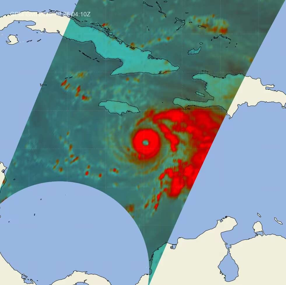
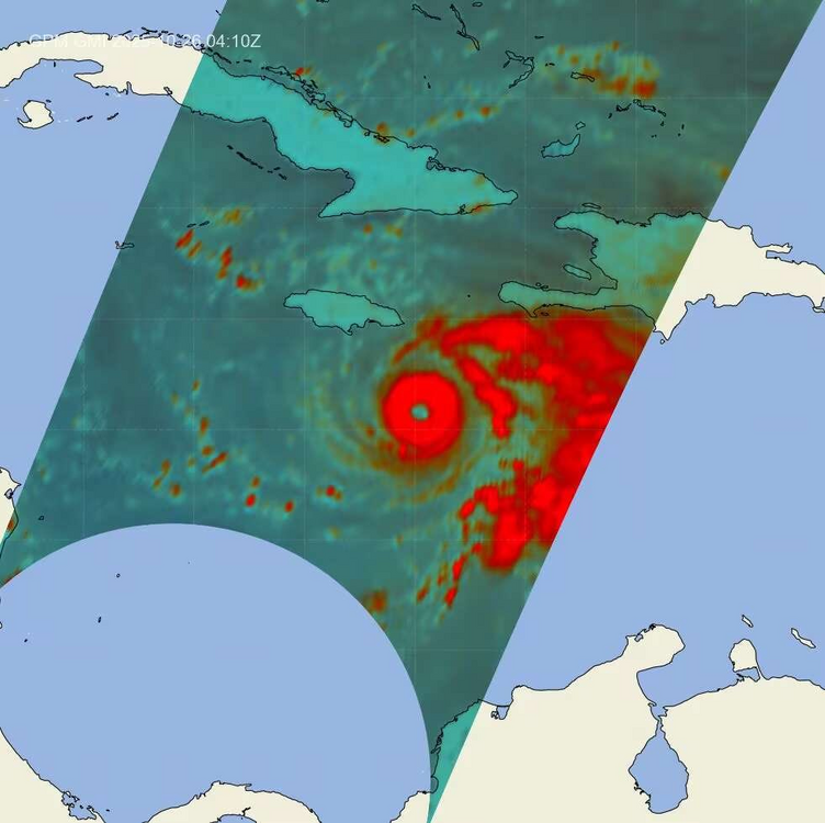
Bombs away with this microwave satellite presentation hot off the press. Very well organized inner core.
-
The same reason people get married.
-
Cold nov/dec = JanuBuried in DCA. Fixed. FebuBuried, too. No mercy. Morched, too.
-
Mid Atlantic will be digging a LOT of snow this winter. Bank on it.
-
I'll keep it 100 by admitting that yes we did get one last bit of the overall weather system tonight. Pretty good real heavy shower with thunder that was loud as hell. May have picked up a quick quarter inch. In a few days, massive cold front will smash into south central Texas bringing our very first official HIGHS in the 60s and lows near 40. Brrrrrrrr! It's gonnabe fun and refreshing! I might take a very slow painful jebwalk in it too. Left knee and foot's a birtch these days. Word to the wise: Too damn much jebwalking when you're young can end up like the Jebman at 61 lmao.
-
Right with you.
-
Satellite actually already looks stronger than the 11PM advisory, looks Cat 4ish. Wouldn't be surprised if it is at 2AM.
- Today
-
Agree
-
Things are looking promising for a big December.
-
It will cool the water at least slowly because it’s taking the potential energy from the warm ocean and converting it into kinetic energy (its a heat engine). That’s related to tropical cyclones redistributing heat to higher latitudes. That’s in addition to any cooling of the surface from upwelling. I believe these are two separate processes.
-
OHC is very deep in that part of the Caribbean. The 26°C isotherm is over 100 meters of depth. It would take a multi-day stall before upwelling became a significant factor, and we're talking in terms of a Category 5 sustaining itself. For all practical purposes, the main reason even slow-moving hurricanes in the western Caribbean can maintain Cat 5 intensity well into November. Some of our most powerful historical Cat 5s were slow movers in that part of the world (Wilma, Mitch, etc.). It's where the Western Hemisphere's version of WPAC typhoons can occur, though still considerably rare.
-

Spooky Season (October Disco Thread)
CPcantmeasuresnow replied to Prismshine Productions's topic in New England
Damn, now I have to adjust my travel plans for the next 46 days. Does this account for mixing? -
967 mb, 115 kts flight level on the last pass. The eye has been tracking south of west this evening.
-
i know its in the warmest water in the entire atlantic but would nor the slow movement cause upwelling?
-
ERC is the only limiting factor left on the table. Not a great place to be in a forecast for an intensifying hurricane.
-
Unfortunately, with atmospheric conditions progressively becoming more favorable with each passing hour, I do not see a scenario where Melissa does not efficiently achieve its MPI. Land interaction or internal structural changes are the only limiting factors until it's picked up by the trough in a few days. I am trying to be optimistic for dry air intrusions or a well timed ERC but that might be wishful thinking. Neither is a given.
-
Unfortunately, with atmospheric conditions progressively becoming more favorable with each passing hour, I do not see a scenario where Melissa does not efficiently achieve its MPI. Land interaction or internal structural changes are the only limiting factors until it's picked up by the trough in a few days. I also like to add, the angle of approach and slow forward speed might also add to Melissa undergoing intensification on landfall. Frictional induced intensification, with the higher terrain forcing Melissa’s core to remain compact and tighten up on final approach. Theres just no scenarios remaining that are “best case scenarios”. No matter what scenario is on the table, each one is equally catastrophic and devastating.
-
Uh-oh.
-
Unfortunately, with atmospheric conditions progressively becoming more favorable with each passing hour, I do not see a scenario where Melissa does not efficiently achieve its MPI. Land interaction or internal structural changes are the only limiting factors until it's picked up by the trough in a few days.
-
Struggling to find a scenario where this isnt a Maria/Mitch level catastrophe for Jamaica and the current tail radar/IR look is not helping that narrative.
-

Spooky Season (October Disco Thread)
OrangeCTWX replied to Prismshine Productions's topic in New England
lol we have had threads started for “snowstorms” modeled farther out then that. Let alone banning them.