All Activity
- Past hour
-

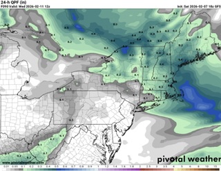
Feb 10-11 Mid Week Minor Event - Ride the hot hand?
Baroclinic Zone replied to HoarfrostHubb's topic in New England
Just peaked at 18z GFS and it looks pretty good. Quick hitting clipper. Mountains will likely fare better but it hits eastern areas pretty good. Look like system gets an injection of moisture from southerly flow from the ocean.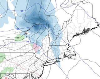
-

Friday February 6 FROPA / WINDEX small event
ORH_wxman replied to HoarfrostHubb's topic in New England
Yep not quite done yet on south shore and cape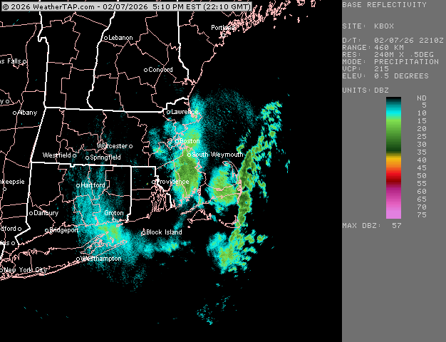
-
 OMFG this is legendary.
 -
 Down to 10F in E CT, wondering how low we go here
 -
Winter Storm Threat *Technical* Discussion. No Op Run PBP or Snow maps
psuhoffman replied to CAPE's topic in Mid Atlantic
The main moving parts are the ridge over Quebec and 50/50 (strength of both) and the timing and strength of the pacific energy ejecting. EPS and AIFS had the most favorable look 12z of the options imo but it’s all still on the table until guidance settles on those features and as of now they’re bounding around every run. -

Winter Storm Threat *Technical* Discussion. No Op Run PBP or Snow maps
Ji replied to CAPE's topic in Mid Atlantic
so this thread is cape just talking to cape? -
If you need to.. I guess - Look, those that "feel" blunt truth is a trolling - grow the fuck up. Try reality for a change. Cold air masses at the same relative thickness are not as kinetically deep at the end of February, because the sun doesn't allow that. deal with it. Plus, the models are over amplified ...routinely, at that range. Add those two together, his point was spot on. These are facts.
-
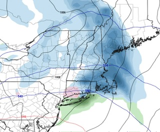
18z GFS is a parade of rain storms
-
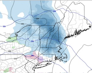
I find this will be a threading the needle type of event. Going to be a very small window with the cold air moving in and out. Going to keep my expectations low unless the models are showing something come Thursday night into Friday morning
-
Go ahead... Start another thread for laughs and giggles!
-

Friday February 6 FROPA / WINDEX small event
Bryan63 replied to HoarfrostHubb's topic in New England
Might not have been a big amount down here but what a fun event to track. When those bands hit, man did it come down. -
Had a gust to 50mph at ISP
-

Friday February 6 FROPA / WINDEX small event
The 4 Seasons replied to HoarfrostHubb's topic in New England
well that was certainly another positive bust/over performer for the season. yet another one. deep winter out there if anyone has any snowfall totals from this event, that are FINAL, let me know. doing a map for this should certainly be interesting and fun. Going to be the 10th 3"+ event of the season. -
February 2026 Medium/ Long Range Discussion: 150K Salary Needed to Post
Ji replied to Weather Will's topic in Mid Atlantic
what is this @mappy The recent visitors block is disabled and is not being shown to other users. -
February 2026 Medium/ Long Range Discussion: 150K Salary Needed to Post
Ji replied to Weather Will's topic in Mid Atlantic
my block thing isnt working. I blocked him and now im seeing all his posts again smh -
Friday February 6 FROPA / WINDEX small event
ORH_wxman replied to HoarfrostHubb's topic in New England
4.5” but this is without clearing. Might have maybe squeaked 4.8-5” if I cleared after the midnight-6am batch.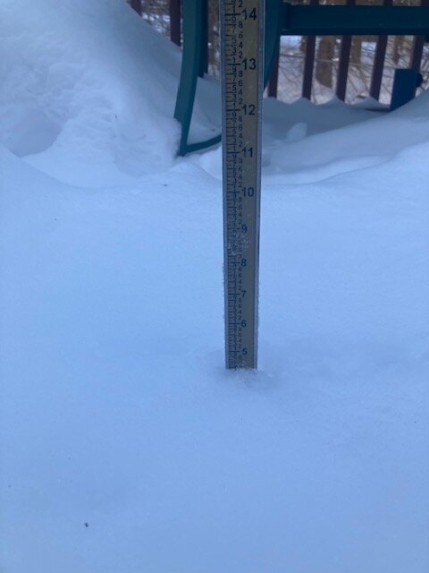
-
Temp has been around 17 since early this morning. Was 20 at 6am. The high temp is probably 30 which occurred just after midnight prior to the Arctic front.
-
 Down to 1f. 2. " new overnight and during the day.
 -
Thank you for answering the question “what if there was another Chuck, but who didn’t know anything and was even more annoyingly repetitive”. Im not sure who was asking that question but thanks for answering anyways.
-

Feb 10-11 Mid Week Minor Event - Ride the hot hand?
HoarfrostHubb replied to HoarfrostHubb's topic in New England
yeah. I could see nothing coming of it. maybe it comes back -
Northern tier of CONUS appears to hold on to the general ridge W. trough E. Favorite time of the year for phasing with the greatest chance for blockbusters.
-
 This one and 18th system seems to go up through the MW into ND, MN.
 -
Currently 1.5 here with winds still gusting 25-35 mph. Just too bad that s/w didn't rotate off the coast about 100 or so miles further south and start to go negative. That surface low would have delivered the goods to this entire sub forum. Another near miss of something really good! So close.
-
Peaks gusts at the airports DCA: 58 BWI: 57 IAD: 52
-
 high today was 22.7° at midnight, and 17.1° at 12, it's now 0, with 23 sustained and gusts 45+, only got an inch new but seems like more with the wind blowing it over everything old, nice little refresher hopefully more by the end of next weekend.


.thumb.jpg.a628c2147efdff1c820341d5143d9237.jpg)


