All Activity
- Past hour
-

White Christmas Miracle? December 23-24th
Sey-Mour Snow replied to Baroclinic Zone's topic in New England
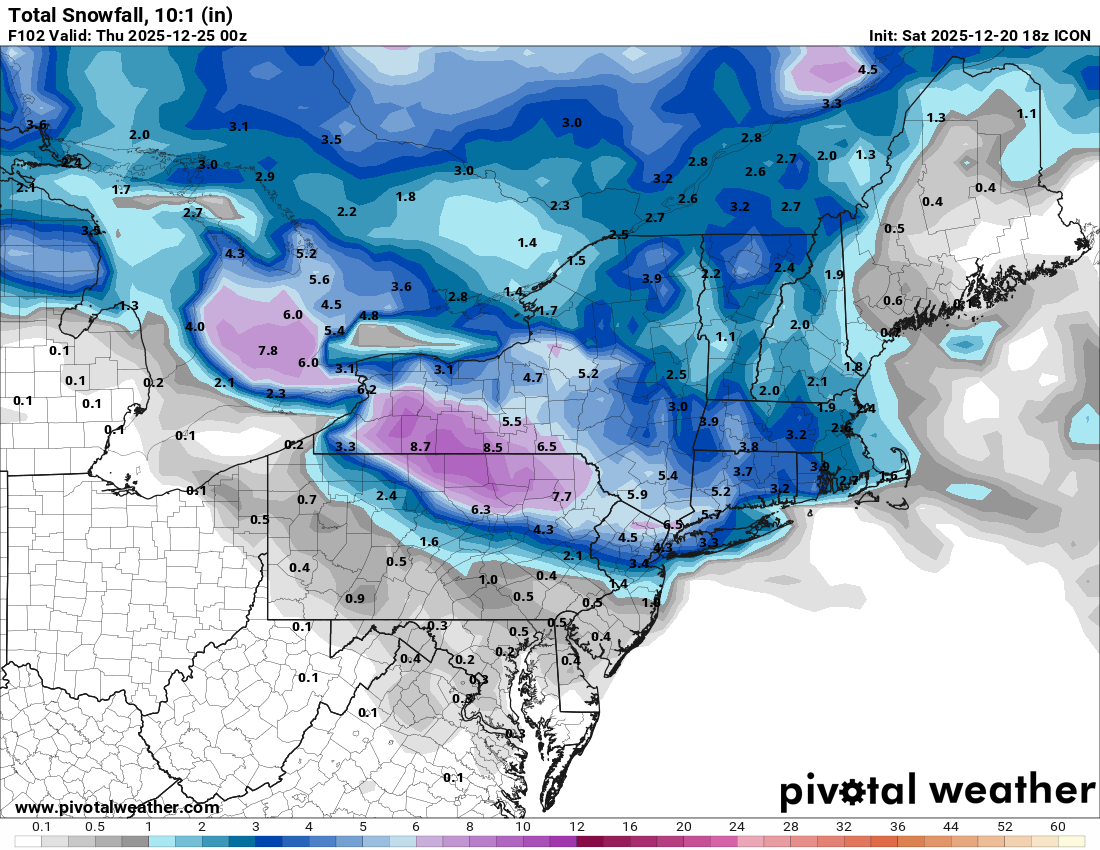
LOL the replacement for NAM and HRRR: RRFS is a toaster bath for most of this forum.. It ticked SW another 35 miles from 12z.. It has 1-3" for SWCT down to central jersey and shutouts everyone else.. RRFS did really good with the last storm, so it has my attention.. It will have to earn our respect though.. -
Well.. it's here now and it's here for the foreseeable future lol. Delayed but never denied.
-

White Christmas Miracle? December 23-24th
Damage In Tolland replied to Baroclinic Zone's topic in New England
I’m not thinking that’s real this time . Maybe -
White Christmas Miracle? December 23-24th
Sey-Mour Snow replied to Baroclinic Zone's topic in New England
Just wait for the 18z gfs and euro to bring you and TauntonMeh back.. -

December 2025 Short/Medium Range Forecast Thread
Carvers Gap replied to John1122's topic in Tennessee Valley
The Euro Weeklies control had an EPO ridge, NAO, and trough east of Hawaii. -

Possible Light Snowfall (1" - 4") on Tuesday Dec 23
NEG NAO replied to Northof78's topic in New York City Metro
I still think any of these solutions is possible since we are still closer to 60 hours from the event - we are right on the border of the cold enough air and significant enough precip - could go either way....... -

Possible Light Snowfall (1" - 4") on Tuesday Dec 23
eduggs replied to Northof78's topic in New York City Metro
The RGEM wasn't further north. The shortwave was actually a hair south. But lighter precipitation and different distribution of precipitation screwed the impression. ICON and RRFS highlighting the potential for a narrow area of heavier banding. Some indications of possible 0.1" liquid per hour. It probably wouldn't last too long as it shifts east, but it could put down a quick couple of inches if we're lucky. -
December 2025 Short/Medium Range Forecast Thread
Carvers Gap replied to John1122's topic in Tennessee Valley
The control run of the Weeklies looked like this…the best run of the season for the control, -
Nice to have the lawn back. Back to have a catch with the kids, etc
-
Yeah, I saw a big dust cloud towards Boulder driving up to Thornton on 25 yesterday, but winds throughout most the metro area were pretty weak.
-
Very persistent pattern. Something similar has happened before...1917 had an insanely warm and persistent pattern for the PNW/West. This one just looks a bit warmer and more persistent. Don't tell the residents of Juneau, Fairbanks, or Whitehorse that this is what future Decembers will look like. All three are on track for one of their coldest Decembers on record.
-

Possible Light Snowfall (1" - 4") on Tuesday Dec 23
MJO812 replied to Northof78's topic in New York City Metro
Icon
-
As shocked as I was when the sun came up this morning
-
December 2025 Short/Medium Range Forecast Thread
Carvers Gap replied to John1122's topic in Tennessee Valley
FWIW, the Euro control Weeklies looked just fine…even bullish on cold. -
We haven't had any particularly good setups for snow this late fall and early winter and yet there have been several accumulating snow events, particularly for NW areas. It's a little frustrating to not have any bigger events to track, but I must admit December has felt pretty wintry compared to recent years. Maybe that continues early Tue... There are some indications of a pretty good burst of snow with cold antecedent conditions. That would continue the trend of sneaking accumulating snow out of a marginally favorable setup.
-
Possible Light Snowfall (1" - 4") on Tuesday Dec 23
MJO812 replied to Northof78's topic in New York City Metro
Rgem further north but its in the long range. -
December 2025 Short/Medium Range Forecast Thread
Carvers Gap replied to John1122's topic in Tennessee Valley
The good thing is the Weeklies have been pretty awful this winter so far. I don’t think ensembles will handle this pattern well quite yet. Reference my post above. -
Possible Light Snowfall (1" - 4") on Tuesday Dec 23
eduggs replied to Northof78's topic in New York City Metro
The RRFS actually has additional snow showers for the area (esp N) Tue night. Doubtful since there's not much support and the RRFS isn't reliable at the end of its run. But if the tight thermal boundary stays close to our area and we remain on the cold side, there will be chances for snow. Different models at different times have shown snow chances every day from Tue through Fri. It depends on the track of the very minor shortwaves in the longwave flow and how they interact with the thermal boundary. At some point next week I suspect we'll switch to warmth... but it's not certain yet. -
Same with sunday river, in fact more trails open today then Thursday Sent from my SM-S921U using Tapatalk
-

White Christmas Miracle? December 23-24th
DavisStraight replied to Baroclinic Zone's topic in New England
Maybe a Norlin surprise for some on the coast. -
Possible Light Snowfall (1" - 4") on Tuesday Dec 23
MJO812 replied to Northof78's topic in New York City Metro
.thumb.png.22324d37025248b599b072cc9cfcf0e4.png)
-
Dude. We HEARD YOU. Please seriously consider going for a walk or something. It doesnt need to be repeated numerous times a day.
-

December 2025 Short/Medium Range Forecast Thread
jaxjagman replied to John1122's topic in Tennessee Valley
More like a NINO the AR out west -
Possible Light Snowfall (1" - 4") on Tuesday Dec 23
eduggs replied to Northof78's topic in New York City Metro
RRFS is even further south than 12z. Precip is not quite as robust as 12z but it's basically all snow for our area except maybe ELI. Quick burst then the forcing quickly fizzles. Not much snow for SNE. Good sign to see the south shift but we don't want to lose the signal for heavier banding. -
That will save on my wood pile!!!!!!


.png.0e74730599c64d9e011f9b23c6fa9e14.png)

