All Activity
- Past hour
-
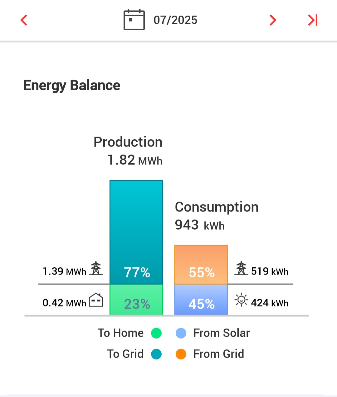
Solar is awesome. Barely a bill year round.
-
We have 3/4 who come out at dusk.
-
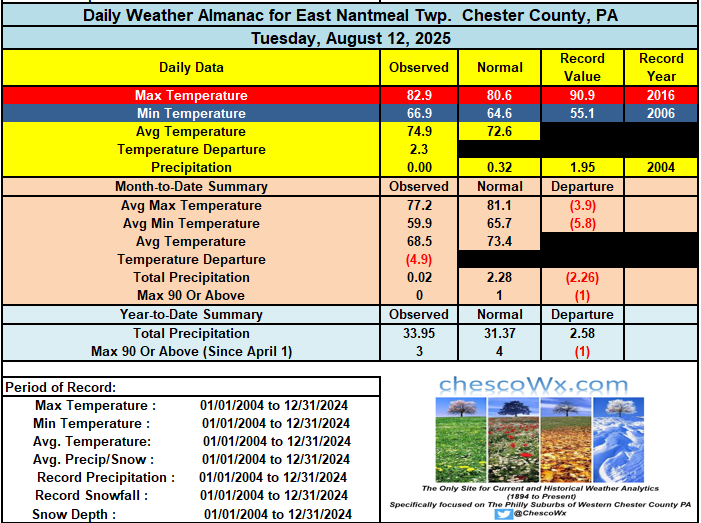
 86/75 here right now, definitely the worst day of the week so far.
 -
 it's actually cleared out again, I wonder if the clouds will stay away for the rest of the day? deep blue skies now just like yesterday!
 -
it's very comfortable right now. I turn off my a/c every night around 2-3 am when I get up for meteor viewing because it's freezing.
-
You need solar. A friend of mine was getting bills like that in the winter with electric heat, he installed solar and has been saving a lot of money.
-
Yeah it wasn't even close lol Cant even say which model did the best because NONE of them did well!!
-
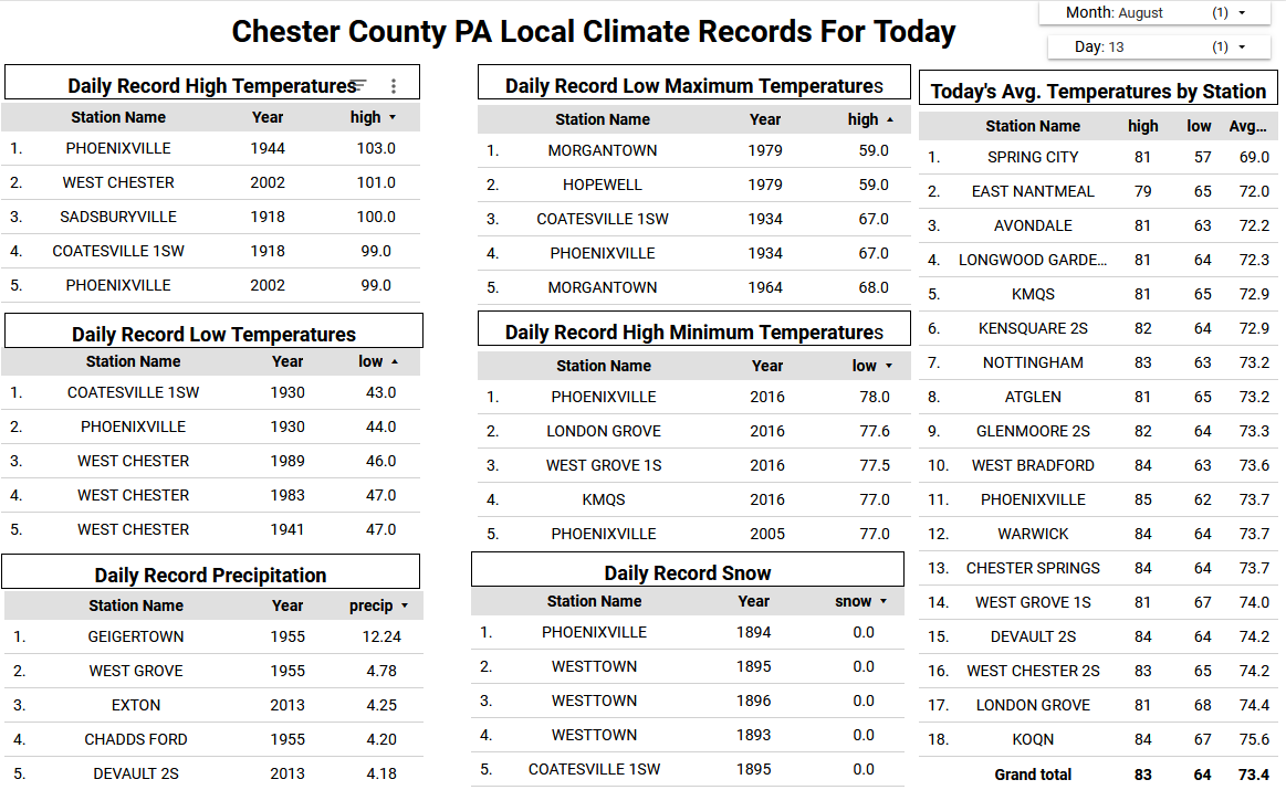
Indeed. 91/92 the past 2 days, and here in the woods we aren't likely to reach the upper 90s of the AUG/BGR airports. (That 92 sets a new max for August here.) We've had only 2 heat waves here, June 27-29, 1999 and August 13-15, 2002. Only some siggy clouds would prevent #3 as today's launch pad was near 60, again - relatively dry equals quick heat. Day 1 of our annual forestry "peer review" field trip stayed mostly in deep shade, fortunately, and so far no reports of tick encounters. They seem to disappear here in August, but unfortunately they're back in a big way a month from now. Today's agenda includes some strategies for protecting brown ash from EAB, as the species has shown little/no resistance and it's culturally critical to indigenous peoples in NNE and the Maritimes/southern PQ. (I'm skipping today in favor of resting my new knee joint and surrounding tissue.)
-
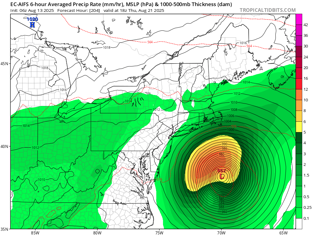
If Erin strengthens then she fishes. If she doesn't strengthen, then she gulfs. She has no path to SNE.
-

Tropical Storm Erin - 45 mph - W @ 20
GaWx replied to BarryStantonGBP's topic in Tropical Headquarters
From Storm 2K regarding 6Z tropical models: peaks as a MH on 3 of 4 06z, August 13, hurricane model blend, Erin--- Model peak intensity ---HWRF = 944mb/112ktHMON = 979mb/95ktHAFS-A = 943mb/119ktHAFS-B = 939mb/121kt -
Not over yet

-
We need it. 1.35 ar BDR since 7/1
-
True - I’m playing the “predict against it” in case it happens. My garden is brown as can be.
-
You bring new meaning to "glass half empty". In this newer climate, not really worried about getting a hurricane up here in the next several years, at least with respect to the higher SST's, and we are overdue climatalogically. I'm not sure what impact the faster/compressed flow has on those chances.
-

Tropical Storm Erin - 45 mph - W @ 20
Wannabehippie replied to BarryStantonGBP's topic in Tropical Headquarters
Of course he would NEVER manipulate data to make it look like he is the best right? -

2025-2026 ENSO
40/70 Benchmark replied to 40/70 Benchmark's topic in Weather Forecasting and Discussion
Yes, I'm not necessarily arguing for a wholescale pattern change....just a rising PDO that will be somewhat less negative. -

Tropical Storm Erin - 45 mph - W @ 20
RevWarReenactor replied to BarryStantonGBP's topic in Tropical Headquarters
Originally it showed it hitting NJ/NYC and held that idea for a bit. So it caused a good bit of concern. I was on the Jersey beaches when it was closest and the waves were crazy and you could look out and just see black. Cape Cod did got hit a bit from it. From a tracking perspective it was a lot of fun, even if it was essentially a no show. -
There has also been a propensity for -PMM the last several winters and thus a weak to very weak STJ….
-
 Long range models were bad nothing near what was predicted a week ago here
 -
Tropical Storm Erin - 45 mph - W @ 20
40/70 Benchmark replied to BarryStantonGBP's topic in Tropical Headquarters
I lost my mind with Edouard....I was a HS kid and didn't know any better. I was so excited and ended up absolutely despondent. -

Tropical Storm Erin - 45 mph - W @ 20
donsutherland1 replied to BarryStantonGBP's topic in Tropical Headquarters
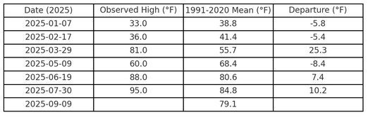
I agree with your overall point. There is a lot of sensationalism e.g., on X. Unfortunately, it's not called out effectively. Most meteorologists who call it out point to posts by non-meteorologists, while ignoring the sometimes even more sensationalist posts of their peers. As for Lezak, I don't follow him. As I saw someone had inquired earlier and I had some information that had been sent to me, I posted it. He has an interesting hypothesis (to his credit, he published on it), but I am not sure how well it works in practice. I haven't seen any independent verification. I don't place much weight on self-made claims (much as I didn't when the so-called Panasonic Model was described as superior to the ECMWF, but its forecasts and verification were never made publicly available). Indeed, upon looking into his X posts, he suggests that there's a 41-day cycle this year. So, for fun, I constructed tables starting at January 1 and January 7 for NYC's high temperatures to see if there was a consistent warm or cold pattern consistent with his cycle (null hypothesis: there isn't). Here's what I found and the null hypothesis stands: The same variability exists when it comes to precipitation. That's the last I'll say on Lezak's approach. Back to the Tropics, I agree with the recurvature idea. If anything, the case for recurvature has strengthened in recent days, as the trough in eastern Canada looks more impressive on the later guidance. Recurvature will probably occur west of Bermuda but safely off the U.S. East Coast. Further, as the peak of Atlantic hurricane season is approaching and also given the MJO, it isn't too surprising to see the Atlantic come to life.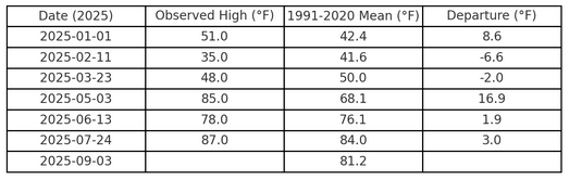
-
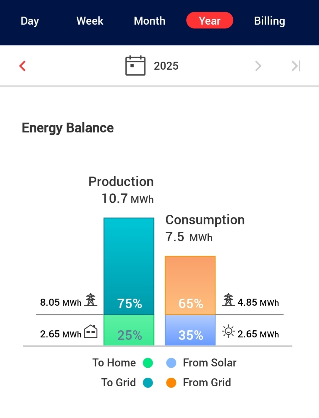
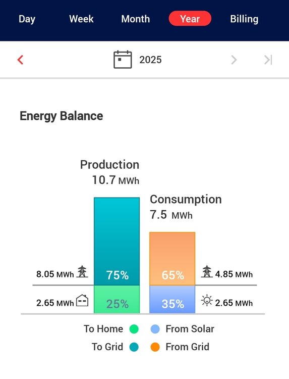
Doubled up July and will be up 4mWh on the year before the end of August, which will cover the entire heating season.

-
Tropical Storm Erin - 45 mph - W @ 20
40/70 Benchmark replied to BarryStantonGBP's topic in Tropical Headquarters
One thing I have learned is to always assume a harder recurve with respect to systems paralleling the coast, UNLESS there is a patently obvious reason not to, such as vigorous ULL absorbing the system....which are exceptionally rare occurences. This is why major NE strikes are so exceedingly rare. -
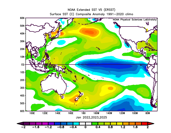
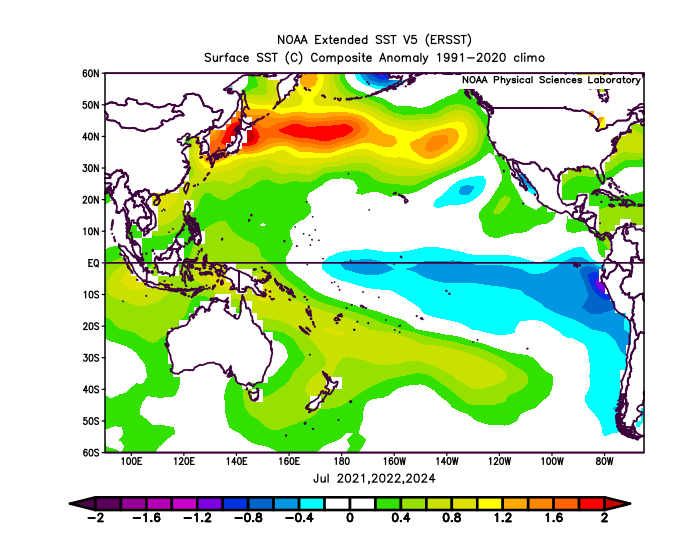
I think what we have been seeing from that record warm pool east of Japan in the 2020s is a seasonal shift from the summer into the fall and winter. The SST anomalies have been peaking there during the summers. Then declining as we have moved into the winter. Notice how the -PDO readings have also been following this pattern. The summer into fall 2021, 2022, and 2024 displayed a similar process. The lowest -PDO readings have occurred in the summer and fall and have risen into the winter. So the 21-22, 22-23, and 24-25 winters were all rising PDO patterns off the strongly negative values of the summer and fall. The main theme is that this seasonal pattern has kept repeating. So the winter values can’t get high enough to reverse the PDO when it starts declining again into the summers. The SSTs are marker for the 500mb ridging which keeps returning to the same areas. So even when we had a weaker trough east of Japan last winter, the SSTs couldn’t fully cool down. This could be related to the deep subsurface warmth there. Then there could be a feedback process between the atmosphere and SSTs perpetuating the 500mb pattern and extended record SSTs and -PDOs.
-
Showers and thunderstorms are becoming more likely as we move toward later this afternoon and into the night. For most spots this will be our first measurable rain since August 1st. The sun returns by Friday with above normal temperatures through the weekend and then cool back to near to below normal by early in the new work week. Our best chance at what could very well be our last 90 plus day of the summer looks to be Sunday.