All Activity
- Past hour
-

January 24-26: Miracle or Mirage JV/Banter Thread!
TSSN+ replied to SnowenOutThere's topic in Mid Atlantic
I have to work unfortunately -

January 24-26: Miracle or Mirage JV/Banter Thread!
Scraff replied to SnowenOutThere's topic in Mid Atlantic
Throwing this out there too. I’ll be at Other Half Brewing tomorrow from 12-4. They have wine and cocktails too. Even a few N/As to boot. Let me know. Love talking beer and snow all damn day. Bet nobody in here knew that about me. -

“Cory’s in LA! Let’s MECS!” Jan. 24-26 Disco
moneypitmike replied to TheSnowman's topic in New England
Should have fired him after last season. -

Pittsburgh/Western PA WINTER ‘25/‘26
Rd9108 replied to Burghblizz's topic in Upstate New York/Pennsylvania
-

“Cory’s in LA! Let’s MECS!” Jan. 24-26 Disco
ri_lurker1314 replied to TheSnowman's topic in New England
Does a 6:45AM flight out of Logan Monday AM have a chance to get out? I wonder about all of the different dynamics. Doesn't seem to be blizzardish, and I've taken off on trips where the snow was definitely heavy. That said, it didn't come after a foot of snow previously needed to clear from the runway, but alas. -
2 extremely trustworthy models at range.
-

January 24-26: Miracle or Mirage JV/Banter Thread!
TowsonWeather replied to SnowenOutThere's topic in Mid Atlantic
I don't wanna bang on CWG, but wtf is this? https://x.com/capitalweather/status/2014307915096617399?s=20 Only an 85% chance of ONE inch of snow? lol... -
In the overall pattern, they have been in the long range. But I don't know if that applies in the short range....probably not, since each storm is different with its unique conditions.
-
12z HRRR had the same thing.
-

Possible Record Breaking Cold + Snow Sunday 1/25 - Tuesday 1/27
SACRUS replied to TriPol's topic in New York City Metro
From my review the NBM General weighting philosophy Time RangeHeavier Weight 0–24hHRRR, RAP, obs 24–48hNAM, HRRR, HREF 48–72hNAM + globals 3–5 daysEuro, CMC, ensembles 5–7 daysEnsembles dominate It’s NOAA/NWS’s official blended forecast system, designed to combine many models, ensembles, and observations into a single, statistically optimized forecast for sensible weather (temps, precip, wind, snow, etc.). What goes into the NBM (Inputs)? Global Models ECMWF (Euro) GFS CMC (GGEM) UKMET ICON (limited elements) Ensembles EPS GEFS GEPS HREF (short range) Regional / Mesoscale HRRR NAM / NAM-Nest RAP RGEM Observations & Post-Processing Surface observations Climatology MOS-style bias correction Downscaling to fine grids (~2.5 km) -
-
 I think it also attempts to adjust for model biases. That has to be the reason why the blend is currently higher than any of the models that it’s blending. there was a slightly confusing post in the mid Atlantic sub forum that suggested that a few recent high ratio storms that were positive busts account for the strong positive adjustment that it’s clearly making here
 -

1/24-1/25 Major Winter Storm - S. IL, IN, MI and OH
A-L-E-K replied to A-L-E-K's topic in Lakes/Ohio Valley
this is your moment^ -

January 24-26: Miracle or Mirage JV/Banter Thread!
dailylurker replied to SnowenOutThere's topic in Mid Atlantic
Life is short my friend. I'm sorry to soon hear about that battery leaving you stranded. -
Oh how us northerners pray!
-
.thumb.jpg.6a4895b2a43f87359e4e7d04a6fa0d14.jpg)
Central PA Winter 25/26 Discussion and Obs
Yardstickgozinya replied to MAG5035's topic in Upstate New York/Pennsylvania
Well if I ever decide to end it all, I know exactly how i'm going to do it. Yeah, f****** hot air balloon ride right into a Kocin-Uccellin . That's how f****** legends are made fellas. -
Looking over Kuchera it looks like the average GFS ratio is ~14:1 while the average Euro ratio will be ~13:1 (for DC, Balt) Take from that what you will, but I would say that's a decent estimate, if anything a little bit high.
-
January 24-26: Miracle or Mirage JV/Banter Thread!
TSSN+ replied to SnowenOutThere's topic in Mid Atlantic
Not the kind of rim job I want -

January 24-26: Miracle or Mirage JV/Banter Thread!
SnowenOutThere replied to SnowenOutThere's topic in Mid Atlantic
What do you think for Cvill. I've been telling people 4-8 low end with an inch of two of sleet and the possibility of .5+ freezing rain or the high end snowfall of 8-14 with an inch or two of sleet. -
Through 24hr, better cold push over the east on the NAM.
-
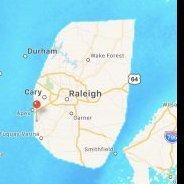
Less qpf, but still 1.3" in Raleigh on the 06z
-
Haven't the models recently been underplaying cold the past few weeks? Or have they been generally accurate. I recall convos about forecasts busting low. Are we expecting the models to have the temps correct on the high side for this storm for mixing? Even if there is a warm nose. Could that be accurate? Or would it be something that could only be determined at game time?
-

Possible Record Breaking Cold + Snow Sunday 1/25 - Tuesday 1/27
Rjay replied to TriPol's topic in New York City Metro
The models... -
He’s shook from 4 years of shit. Frankly I am too lol.
-
 let's be realistic here for once the that i am wants to believe that but when models show that warm nose aloft, forget we will change to sleet from yorktown and south! Look for a trend that could push that warm nose down to let's say staten island or whatever. and boom we will all be happy. It could happen you want an earlier south transfer and you want that coastal to crank, that thing is a pos right now 1004 millibar low very weak at this time as it is being depicted. You want some type of 996 or lower for a chance to actually cool down those columns really quick and not have that warm nose creep north any further!