All Activity
- Past hour
-

Ice Ice Baby December 28-29 Storm Discussion
ineedsnow replied to Baroclinic Zone's topic in New England
I just hope we get some glaze on top of the snow before we warm -
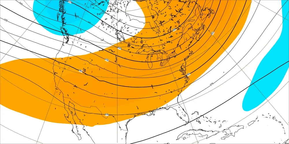
6z Gfs (days 8-9) is a perfect example of a wasted block. But this run is so different from 0z, it's beyond entertainment and fantasy.
-
1 degree in Westfield.
- Today
-

Ice Ice Baby December 28-29 Storm Discussion
Sugarloaf1989 replied to Baroclinic Zone's topic in New England
7F here. On December 2nd it didn't get above freezing. Feezing rain for a few hours. -
Any sun is not happening for Sunday, according to NWS and TWC/Wunderground. Can expect the high of 66 to be a nighttime high.
-

Ice Ice Baby December 28-29 Storm Discussion
Modfan2 replied to Baroclinic Zone's topic in New England
Down to 3F in the valley in Eastern CT, a little concerned that cold air here will be hard to erode. Hoping we warm nicely today -

January 2026 regional war/obs/disco thread
SnoSki14 replied to Baroclinic Zone's topic in New England
If I had an inch for every "potential" in the last decade my house would be buried under 30 feet of snow drifts. Latest EPS looks really good though, not gonna lie -

Winter 2025-26 Medium/Long Range Discussion
DocATL replied to michsnowfreak's topic in Lakes/Ohio Valley
Nothing says Chicagoland winter better than wintery temps without wintery precipitation. Early December was a fun time but now we’re at real winter. -
Down to 3F here in Eastern CT, wasn’t expecting to be this cold
-

Texas 2025 Discussion/Observations
Stx_Thunder replied to Stx_Thunder's topic in Central/Western States
Almost every part of the state now has either or both, broken a max daytime or overnight high minimum temp record this week. Amarillo & El Paso are also included looking at Nexlab data. Amarillo has broken both daytime high and overnight high minimum temp records this week. And so has some cities in ETX/SETX, like College Station and Tyler. Also, Texarkana has set a new all-time record high for December this year.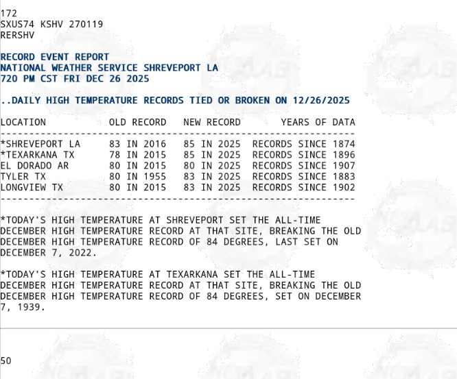
-
Where we want it is usually what we say.
-

Wounded Duck Strikes Back: Dec 26 & 27th Winter Storm Obs
40/70 Benchmark replied to WxWatcher007's topic in New England
I'm not upset at you at all . The frustration is strictly over the weather.... -
Hope the warm front ends up in Alpena
-
December 2025 regional war/obs/disco thread
Sugarloaf1989 replied to Torch Tiger's topic in New England
8F here. I wonder if the cold air gets trapped like December 2nd. It never got above freezing. -
Legit upper air pattern incoming and a bunch of chances to track. That’s really all we should be taking from models this far out. Specifics of a given threat is pointless at this range. If models hold this look for the next week, we have reason to get excited.
-
MWN +19 and First Lake -14 tells you how fake the cold is.
-

Wounded Duck Strikes Back: Dec 26 & 27th Winter Storm Obs
The 4 Seasons replied to WxWatcher007's topic in New England
I really love that Dec 16-17, 2020 blizzard. Getting a 12"+ snowstorm during December is exceedingly rate probably the only time in my life I've seen one around here. Despite those 35-45" reports from that death band I was more than happy with what we got. And those gravity waves at the end were cool as sh*t. -
Our area had a sweaty 80 high today.
-

Wounded Duck Strikes Back: Dec 26 & 27th Winter Storm Obs
vortex95 replied to WxWatcher007's topic in New England
Are you upset b/c of my earlier post? I am just trying to keep things in proper context/perspective. I don't know what to tell you as to the lame period now. Just one of those things when a certain areas in a period get ripped off, and some more than other even within the same lame period. It happens due to law of averages and large numbers, and in many locations around the world when you consider all that can and can not happen. You can slice and dice things down and find a lot more "screw zones" if you really work at it, and sometimes due to bad luck or random chance, they are going to end up right in your location. I can given you an exceptional example from Woburn. From the 1984-85 to 1991-1992 seasons, my biggest single storm total was only 11". That's really lame for such a long period, considering my location is ideal often for being just staying on the cold side of the coastal front, and a bit of QPF enhancement that occurs sometimes along the 128 area N&W of BOS in many solid nor'easters. You know how common a foot plus in single storms was 1992-93 to 2015-16? It truly that shows how exceptional that lame period was. -
How to keep the Gulf of Alaska low from flooding pacific air into the NA continent. Pac jet pumps the Alaskan ridge into steroid range, and sends snow level cold to Florida.
-
Wounded Duck Strikes Back: Dec 26 & 27th Winter Storm Obs
40/70 Benchmark replied to WxWatcher007's topic in New England
It's cute how you list all of these meteorological milestones in areas where I do not reside, as if that will sway my opinion of my much it's sucked diseased donkey balls where I live. -

Ice Ice Baby December 28-29 Storm Discussion
dendrite replied to Baroclinic Zone's topic in New England
Monday’s morning commute may suck, but otherwise this is overblown. -
Wounded Duck Strikes Back: Dec 26 & 27th Winter Storm Obs
40/70 Benchmark replied to WxWatcher007's topic in New England
When you got boned in both "blockbusters", absolutely. I mentioned January 2024 because I didn't get boned in the January 7th event....I would also take December 2019, and February 2021. -
0z Euro....lol
-
When you consider that both the EPS and GEFS have had a notable -PNA bias/notable warm bias from your area eastward and that all -ENSO -PNA Decs have transitioned to +PNA Jans, these consistently much better pattern maps for mid-Jan are quite encouraging. Just 5 days ago, the EW had this ugly -PNA for 1/12-18: