All Activity
- Past hour
-
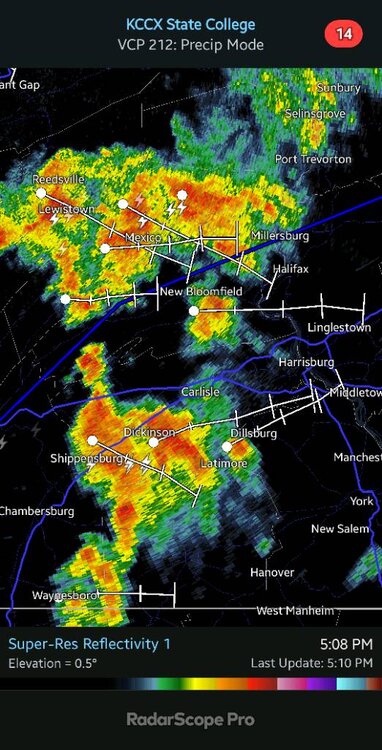
Big storms to my far NW, and radar shows a outflow boundary moving South, hmm.
-

Hurricane Erin: 125 MPH - 946mb - WNW @ 13
BooneWX replied to BarryStantonGBP's topic in Tropical Headquarters
Looks like it’s completing the EWRC. The center is warming quickly on IR. -
Very oppressive today. 91/73 presently, but feels much worse. Going to Dewey Beach tomorrow, yee ha !!!!! Should I bring a body board ?
-

Hurricane Erin: 125 MPH - 946mb - WNW @ 13
wthrmn654 replied to BarryStantonGBP's topic in Tropical Headquarters
-
I’m using that term quite loosely. Summer definitely isn’t over but the step down has commenced and that I see as it’s back being broken. IMO, high summer these days is consistent 85-95 with dews. Before this century, high summer was really 75-85. Times have changed, numbers have changed but yes, 75-80 is still summer, just not prime summer
-
Re-loading for Septdewber
-

E PA/NJ/DE Summer 2025 Obs/Discussion
JTA66 replied to Hurricane Agnes's topic in Philadelphia Region
Reached a high of 91F today but the clouds are starting to roll in, hopefully that will end the madness. I know we’re not finished with the 90’s but I don’t see any in the current forecast…we take! -

Hurricane Erin: 125 MPH - 946mb - WNW @ 13
Wannabehippie replied to BarryStantonGBP's topic in Tropical Headquarters
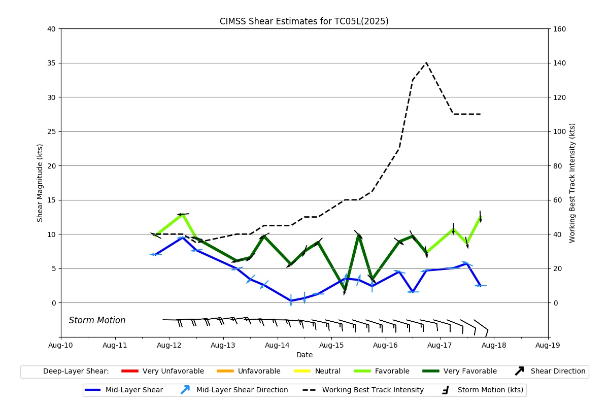
No changes on the latest advisory. 5:00 PM AST Sun Aug 17 Location: 21.7°N 68.5°W Moving: WNW at 13 mph Min pressure: 946 mb Max sustained: 125 mph -
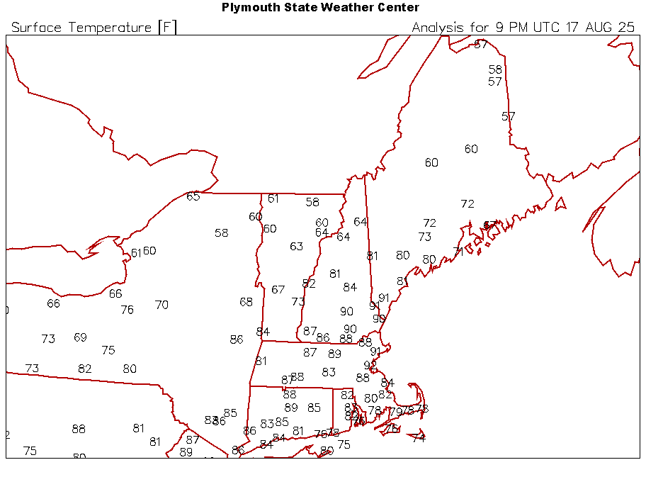
94° at CON today. MHT 93°
-
I see its raining there
-
 Just plain showers on radar that haven’t reached the ground at least not yet up here, there is a thunderstorm to my SE. .35” for the month.
 -
 Today saw hot temperatures across much of the region. Highs included: Bridgeport: 88° Islip: 86° New Haven: 89° New York City-Central Park: 91° New York City-JFK Airport: 85° New York City-LaGuardia Airport: 91° Newark: 94° White Plains: 89° A dramatic change to a sustained period of cooler weather now lies ahead. A cold front will cross the region this evening or tonight bringing some showers or thundershowers. In the wake of the frontal passage, noticeably cooler air will overspread the region. High temperatures will likely reach the upper 70s Monday through Wednesday and then the lower 80s on Thursday and Friday. The extended range guidance continues to suggest that the closing week of August could feature below normal temperatures. Precipitation could be near normal. The synoptic pattern should limit direct tropical cyclone threats for the foreseeable future. Impacts from elevated tides, surf, and rip currents would be the most likely effects produced by Erin as it tracks well offshore between the U.S. East Coast and Bermuda. The ENSO Region 1+2 anomaly was +0.8°C and the Region 3.4 anomaly was -0.3°C for the week centered around August 6. For the past six weeks, the ENSO Region 1+2 anomaly has averaged +0.50°C and the ENSO Region 3.4 anomaly has averaged -0.15°C. Neutral ENSO conditions will likely continue into early autumn. The SOI was +4.49 today. The preliminary Arctic Oscillation (AO) was -0.220 today. Based on sensitivity analysis applied to the latest guidance, there is an implied 66% probability that New York City will have a cooler than normal August (1991-2020 normal). August will likely finish with a mean temperature near 75.4° (0.7° below normal). Supplemental Information: The projected mean would be 0.2° above the 1981-2010 normal monthly value.
 -
It was near 90 at the warmest. Probably mid/upper 80s in the hot spots up here right now. GFS flirts with 90. Nothing excessively hot.
-
Haha, this miss will be hall of fame worthy @canderson Sent from my SM-G970U1 using Tapatalk
-
All this hoopla around about tracking more west and south of guidance and blah blah blah and Erin is going to make the north track and re-curve within what was expected several days ago. Physics and science FTW
-
 Anybody catching a T-Shower? Missed just to the north and just to the south here. Fast moving and likely dropped <.25". Friend in Pittstown, NJ had a T-shower about an hour ago.
 -
I wouldn't be surprised if we saw as many as another half dozen days here in the lower valley where we flirt with 90. Seems pretty easy to do down here
-
That got chilly in a hurry.
-
dry boundaries, eventually cool dry fronts NW to SE. What we need is a distinct change to Meridonal S-N flow we see more in the fall/winter.
-
Do you base your forecasts off of model print out numbers ? If so, no wonder why you’re clueless . You don’t look at a model .. ok it’s showing 84 so that’s what it will be
-
Is the Euro still showing 90's? How about the last week of August?
-
Temps in 70’s and 80’s -near 90 as week goes on the next 7 days with strong sun and 50’s dews early /mid week . Amazing how fast he drops his webs on our face. Steinan Helmet
-
I know. I thought the same.
-
New regime
-
Next weekend looks warm to hot. It’s torched aloft…caveat will be sun. May be another weekend where CNE/NNE does bigger anomalies.