All Activity
- Past hour
-
Quarter or bigger flakes going on out there now, the ground is white. Solid dusting.
-

11/8-11/10 First Snow and Lake Effect Event
homedis replied to Geoboy645's topic in Lakes/Ohio Valley
Quite hard to measure with the wind gusts, but I’m measuring around 2.5” in the past hour. With close to 3” total accumulation thus far in Wicker Park. -

11/8-11/10 First Snow and Lake Effect Event
andyhb replied to Geoboy645's topic in Lakes/Ohio Valley
Visibility is effectively zero on that Skydeck webcam now. -

11/8-11/10 First Snow and Lake Effect Event
TheNiño replied to Geoboy645's topic in Lakes/Ohio Valley
You’re so right haha -

11/8-11/10 First Snow and Lake Effect Event
KeenerWx replied to Geoboy645's topic in Lakes/Ohio Valley
DAB+ vibes now locally as trajectory and upscale radar trends are not promising. Still an awesome event to watch unfold. -
31 and moderate snow currently. This isn't organized enough to get us much of anything, as the snow showers last 20 or so minutes then clear out. Hopefully the sub freezing highs and some instability work in our favor tomorrow afternoon.
-

Fall/Winter Banter - Football, Basketball, Snowball?
Mr Bob replied to John1122's topic in Tennessee Valley
A reset has been done if he could try to log in when he gets a chance. -

November 2025 general discussions and probable topic derailings ...
dendrite replied to Typhoon Tip's topic in New England
Here’s the 500mb vortmax that is inducing the inverted trough. You can see the “kinks” in the isobars it’s causing (the actual trough) as the PVA induces pressure falls. It’s the same type of way we get our inverted troughs. But it’s perfectly situated so that it moves southward over Lake Michigan. The extra instability from the warm lake waters is making this locally heavier than it would’ve been otherwise. And yeah, then the low level flow aligns along the long length of the lake and we get the LES streamer behind it for a short time.

-
November 2025 general discussions and probable topic derailings ...
dendrite replied to Typhoon Tip's topic in New England
So yeah…that’s your inverted trough moving through right now. The LES band is setting up in its wake and will move eastward with time.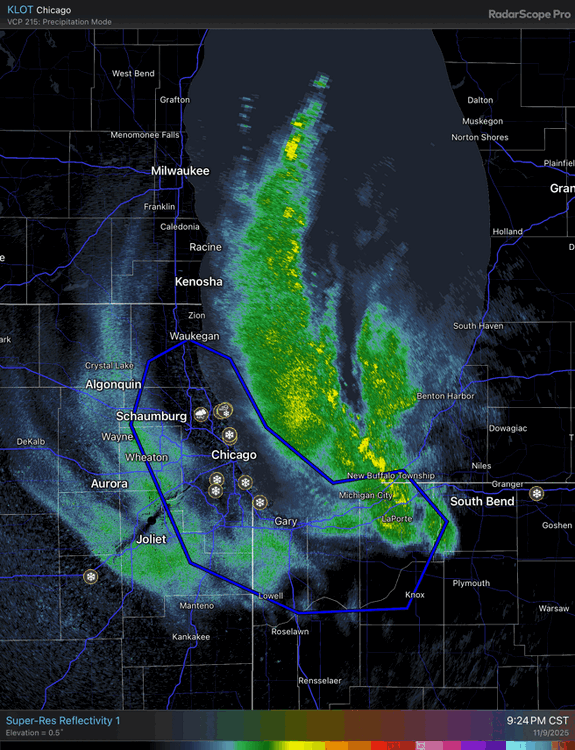
-

November 2025 general discussions and probable topic derailings ...
Snowedin replied to Typhoon Tip's topic in New England
Tropical downpours coming down good right now. Now I know why there’s been so many frogs hopping around this evening!
-
Chicago Webcam https://share.earthcam.net/tJ90CoLmq7TzrY396Yd88LOc-jcDgi0ca-YNv3MI9rc!.tJ90CoLmq7TzrY396Yd88G8-6CLOrQYCFNszQ91PWAs!.tJ90CoLmq7TzrY396Yd88DGHDxm0NvViWeCn-Q5a6NQ!/cub_world_sporting_goods_store/wrigley_field_cam/live
-
11/8-11/10 First Snow and Lake Effect Event
snowman33 replied to Geoboy645's topic in Lakes/Ohio Valley
Can't fathom what is happening, been burned too many times with LES. -
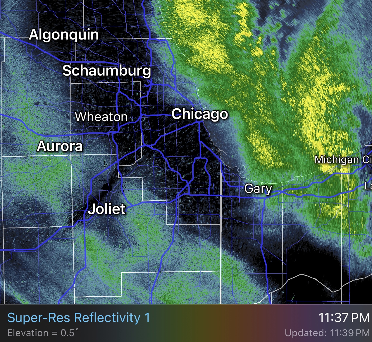
Just out from LOT (11:37 PM): THE INITIAL PUSH OF SNOW THAT DROPPED VIS DOWN TO 3/4SM AT CHICAGO TERMINALS IS PUSHING SOUTHWESTWARD TOWARD KPIA. HOWEVER, THE NEXT BAND OF SNOW IS RIGHT ALONG THE LAKE SHORELINE AT THE TIME THIS DISCUSSION WAS PUBLISHED. CURRENTLY CONDITIONS AT CHICAGO TERMINALS ARE VFR, BUT WITH THE NEXT BAND ABOUT TO MOVE ONSHORE, THE TAFS WERE SENT WITH WORSE CONDITIONS DUE TO THE EXPECTATIONS THAT THINGS WILL DETERIORATE QUICKLY AFTER 06Z. THIS BAND WILL BE HAVE MORE VIGOROUS SNOW RATES AND STRONG GUSTY WINDS. LOW VIS IS EXPECTED, BUT MAY EXCEED EXPECTATIONS AND BECOME SUB-1/4SM. ADDITIONALLY, BUOYS HAVE ALREADY REPORTED GUSTS TO 31 KNOTS, AND WHILE 35 KNOTS IS IN THE TAF, IT IS ENTIRELY POSSIBLE THAT GUSTS TOUCH 40 KNOTS AT TIMES. IT IS POSSIBLE THE THE TEMPO FROM 06Z TO 09Z IS A HAIR LONG, BUT HAVE MODERATE CONFIDENCE THAT THERE COULD BE 3 HOURS OF REALLY INTENSE SNOW RATES. LOOKING AT REGIONAL RADAR, THERE IS A LONG LAKE ORIENTED BAND OFF THE WISCONSIN SHORELINE MOVING SOUTHWARD. THIS BAND WILL BE "ROUND 2" AS IT MOVES INTO ILLINOIS. THERE WILL THE EXPECTATION IS THAT THERE WILL PROBABLY SOME TIME OF "BREAK" IN THE INTENSE SNOW BEFORE IT MOVES SOUTHWARD (LONGER AT KMDW AND KGYY). CAN'T RULE OUT SOME QUICK VFR CONDITIONS, BUT FELT MORE PRUDENT TO LEAVE IFR/MVFR CONDITIONS FOR ONGOING SNOWFALL. NEVERTHELESS, A SECOND ROUND OF INTENSE LAKE EFFECT SNOW IS EXPECTED BEFORE DAYBREAK.
-
11/8-11/10 First Snow and Lake Effect Event
homedis replied to Geoboy645's topic in Lakes/Ohio Valley
Absolutely ripping here. This feels like thundersnow any mintue now… https://imgur.com/a/6GqbyUD -

11/8-11/10 First Snow and Lake Effect Event
OrdIowPitMsp replied to Geoboy645's topic in Lakes/Ohio Valley
https://www.earthcam.com/usa/illinois/chicago/wrigleyfield/?cam=wrigleyfield_hd -
11/8-11/10 First Snow and Lake Effect Event
andyhb replied to Geoboy645's topic in Lakes/Ohio Valley
How has no one said "rdy 2 b buried" yet? -

11/8-11/10 First Snow and Lake Effect Event
sbnwx85 replied to Geoboy645's topic in Lakes/Ohio Valley
whiteout on the lakeshore. You can also drag the cursor back to see what the shot normally looks like. -
11/8-11/10 First Snow and Lake Effect Event
homedis replied to Geoboy645's topic in Lakes/Ohio Valley
Pouring snow in Wicker Park area, flake size has definitely improved. -

11/8-11/10 First Snow and Lake Effect Event
Malacka11 replied to Geoboy645's topic in Lakes/Ohio Valley
@A-L-E-K How is it - Today
-

11/8-11/10 First Snow and Lake Effect Event
OHweather replied to Geoboy645's topic in Lakes/Ohio Valley
Some pretty impressive ascent from the vort max and meso low!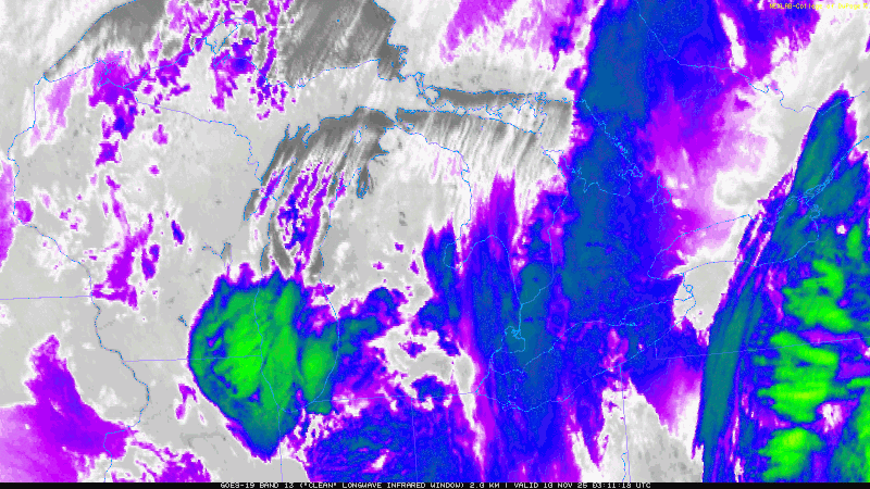
-

November 2025 general discussions and probable topic derailings ...
Supernovice replied to Typhoon Tip's topic in New England
This looks fairly legit and I’m fairly jealous
-
Maybe some flurries this week ?
-

11/8-11/10 First Snow and Lake Effect Event
BuffaloWeather replied to Geoboy645's topic in Lakes/Ohio Valley
You're about to see a Buffalo band, hope you're still awake for this. -
Top 3 thunderstorm for the year here, and perhaps in quite a while. 5 minute pea sized hailstorm, which is rather rare in my local neighborhood. Absolutely torrential rain to boot. And now your never even know it rained. Sent from my Pixel 9 Pro XL using Tapatalk
-
11/8-11/10 First Snow and Lake Effect Event
OHweather replied to Geoboy645's topic in Lakes/Ohio Valley
Yeah it seems like they're alluding to it in their AFD as well. It may be hard to know exactly which way it'll go until the mesolow pushes farther inland/weakens a bit over the next few hours, as that's when the band will be more free to whip west, which it will still want to do based on radar trends farther up the lake. However, the shorter the window for that to happen the better for getting the band to stay more coherent.