All Activity
- Past hour
-
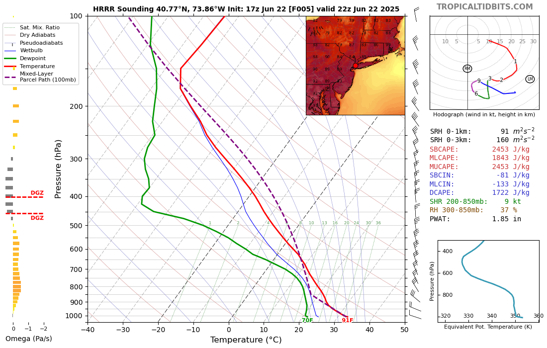
The HRRR has a late day high later in the low 90s.

-

2025 Atlantic Hurricane Season
BarryStantonGBP replied to BarryStantonGBP's topic in Tropical Headquarters
AL, 90, 2025062218, 01, CARQ, 0, 313N, 576W, 20, 1017, LO, 64, NEQ, 0, 0, 0, 0, 1019, 120, 20, 0, 0, L, 0, X, 350, 3, INVEST, S, -
I must be chopped liver or something anymore...
-
This might have been our final rain for the summer, I remember there was zero rain in August that year and all those wildfires.
-
Briefly broke 90F at noon in Holyoke, but clouds on and off knocked us back a bit.. slowly clawing back. 89.2/72.8 now. Florida place is currently 87.1/75.2, so heat index about the same..
-
I think in general it's possible but very difficult at the Park. Places like LGA can have a high at 6 pm or so. Some updated hourly forecasts have low 90s at 7pm. The Park doesn't do late day highs well though. Wet soil and foliage plus evening sun drops below the trees and does reach there. Sometimes Central Park will keep pace with other area obs then flatline in mid afternoon while everyone else not under a sea breeze keeps climbing.
-
High of 76F so far. It’s actually impressive it’s gotten that warm with this cloud cover and upslope flow. Any prolong sun will send it off to the races.
-
Just got back to town and catching up. Was camping with the kids on the Delaware by Milford. Didn’t expect this mornings storms, but good to be away. Yesterday was one of the best days I’ve had on the river. Temp was 68.5 and a good current; barely paddled.
-
Up to 83 with the slowly visible sun
-
Plateauing at 91.5 as the dew comes up
-

E PA/NJ/DE Summer 2025 Obs/Discussion
RedSky replied to Hurricane Agnes's topic in Philadelphia Region
GFS thinks fall weather returns again starting next weekend again what is going on Euro looks like normal summer -
Very true on all accounts. I ended up high and dry but appreciated the respite from the sun while it lasted.
-
96…107 HI. A mere appetizer for the rest of the week
-
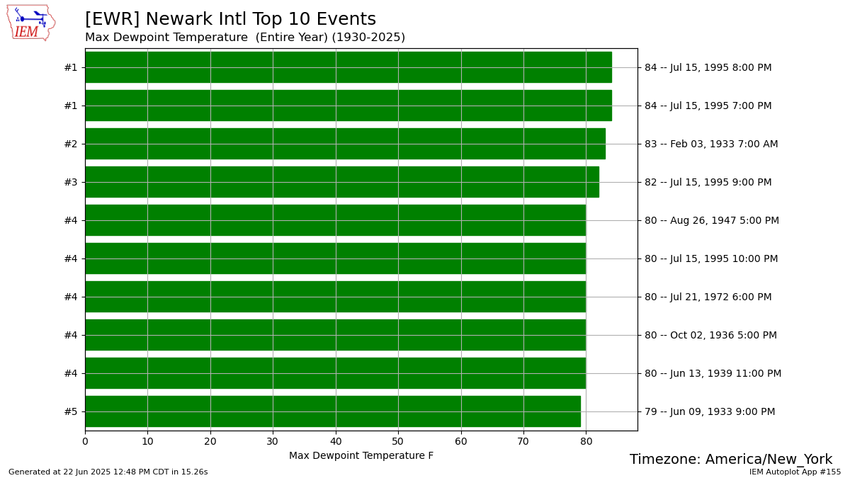
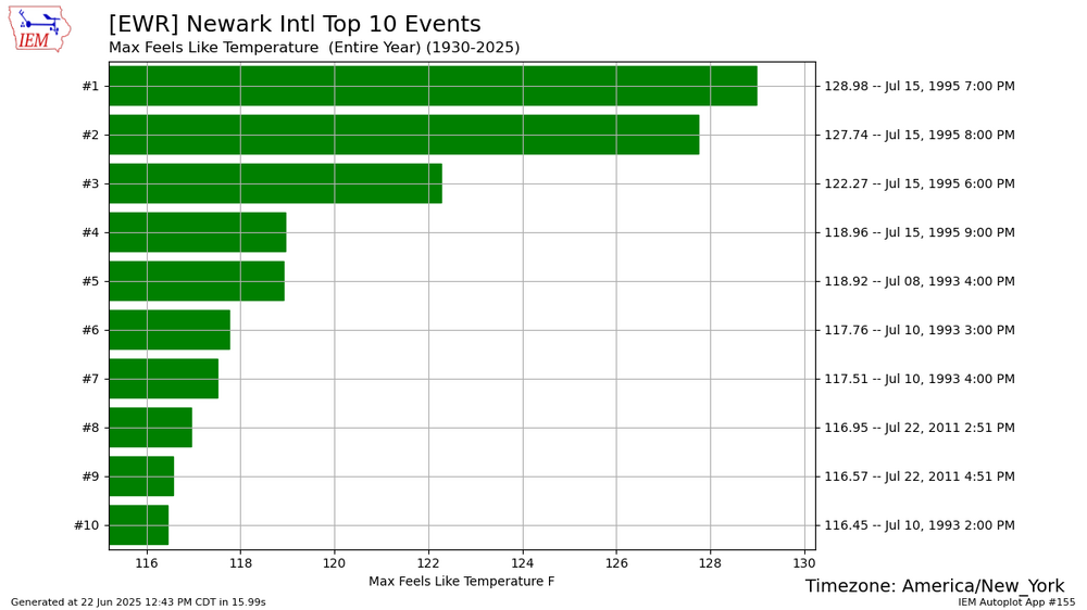
Only if it rains on the day when the expected peak temperatures of any given heatwave are expected to occur. The July 1995 Derecho went just to our north. Then we had the first heat indices near 130° with temps over 100° and dew points near 85°. That was one of the most extreme weather days of the 1990s. The scariest part was probably all the campers in the Adirondacks in tents with 115 mph gusts and one of the most electrified derechos for total CG strikes.
-
88 here, 90 seems possible.
-
There have been 5 official occurrences with a low of 80° at Detroit: July 5, 1921 July 1, 1927 July 1, 1931 July 18, 1942 August 1, 2006 There have been 4 occurrences with a low of 79° and 11 times with a low of 78°. The warmest recorded low at Detroit city airport was 82° on Aug 24, 1968. There were also 7 occurrences with a low of 81° and 8 with a low of 80°.
-
81 lol and a high overcast.
-
Dews are up, seem to be low to mid 70s across the area. Currently 92/75 heat index 103 in silver spring.
-
this streak will be longer than DiMaggio's at this rate Rob!
-
E PA/NJ/DE Summer 2025 Obs/Discussion
RedSky replied to Hurricane Agnes's topic in Philadelphia Region
Windy and 75F Trace of rain thankfully -
it's basically a high overcast. I remember seeing this several times during our 4 day lack of sunshine lol
-
Seeing some good CTG lightning streaks and hearing thunder from the dark clouds and storm to my southeast that won't get me. So close, but yet, so far...
-

Central PA Summer 2025
Mount Joy Snowman replied to Voyager's topic in Upstate New York/Pennsylvania
Just sat on the porch and watched rounds of T’showers roll through. Shocked it didn’t amount to more given the extreme moisture in the atmosphere and the solid radar returns. Perplexing. In any case, quite the forecast miss today, as I literally had 0% POPs for days on end for this time period. Air is THICK. -
82.5 here
-
Yep we're stilling looking at one of the most intense 3 day heat periods ever. Three days in a row of temps around 100 doesn't happen too often. Probably 102 or 103 here on Tuesday.