All Activity
- Past hour
-
High of 86 so far.
-
https://synoptic.envsci.rutgers.edu/satellite/img/vis_nj_anim.gif
-
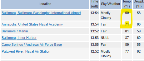
Current temp 91 here EWR: 90 NYC: 88
-
Year # of 90°F+ Days (NYC)s (NYC) 1977 22 days 1990 12 days 2002 32 days Year # of 90°F+ Days (EWR) 1977 26 days 1990 16 days 2002 35 days
-
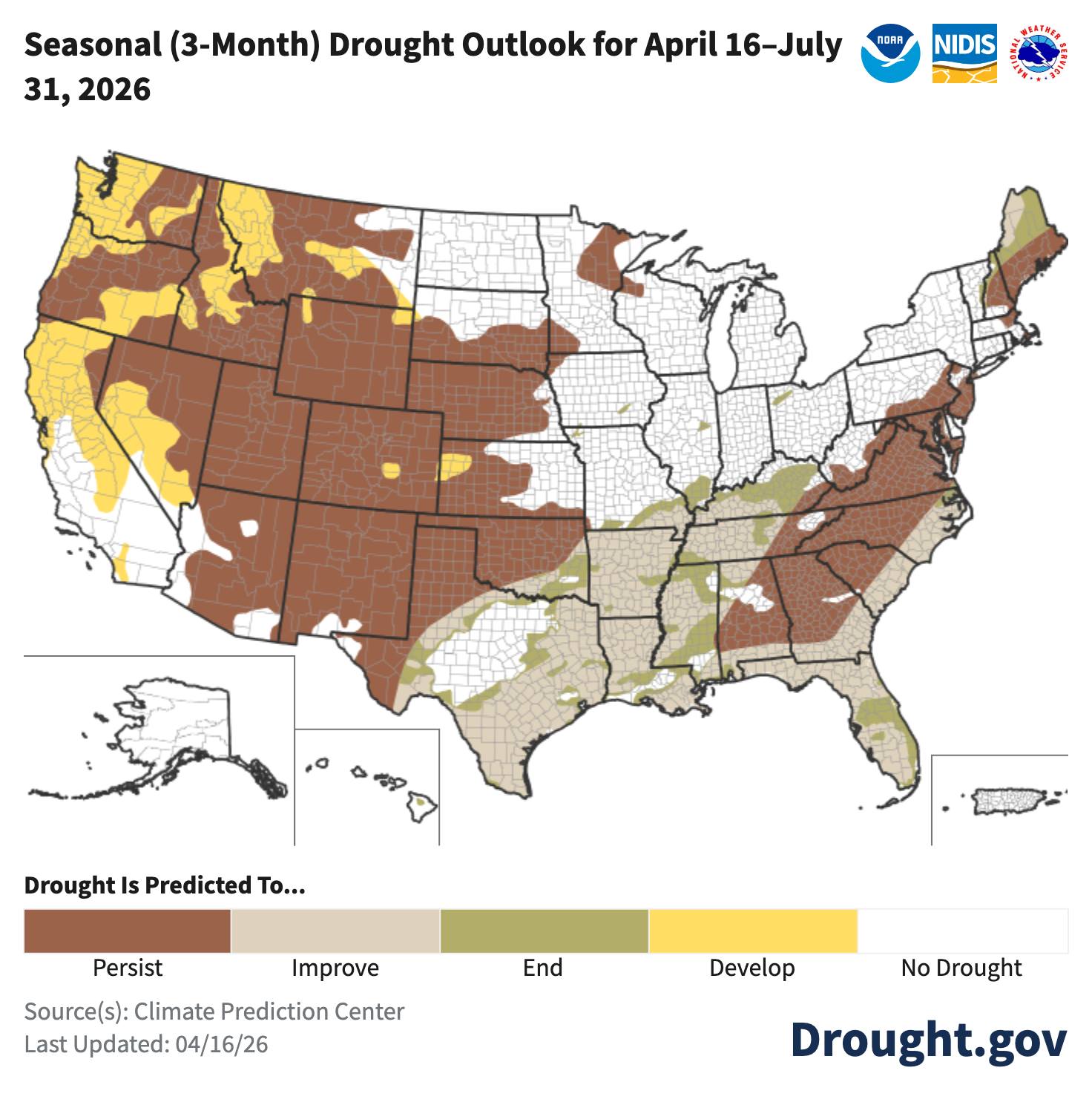
Could be another big day with an expansive Enhanced Risk. Locally, the NAM likes the idea of keeping severe wind gusts going into Michiana late into the evening. Day 2 Convective Outlook NWS Storm Prediction Center Norman OK 1241 PM CDT Thu Apr 16 2026 Valid 171200Z - 181200Z ...THERE IS AN ENHANCED RISK OF SEVERE THUNDERSTORMS EXTENDING FROM WISCONSIN SOUTHWESTWARD INTO OKLAHOMA... ...SUMMARY... Widespread severe thunderstorms are expected from parts of the southern Plains to the Middle and Upper Mississippi Valley vicinity Friday into Friday night. Tornadoes, possibly strong, very large hail, and swaths of damaging winds will be possible. ...Synopsis... An upper trough will move into the central and northern Plains during the day, strengthening through Friday night as it moves into upper MS Valley. Continuous height falls will occur across the entire central to northern Plains region, where mid and upper level temperatures will already be relatively cool. During the afternoon, low pressure will develop across IA and WI, with a cold front extending southwestward into southern KS and northwest OK. A warm front will also lift across IA and into WI during the day, with an influx of mid 60s F dewpoints. Given the cool temperatures aloft, this will create a highly unstable air mass ahead of the cold front. This front will accelerate during the evening as storms become numerous, and should extend roughly from Lower MI into central TX by 12Z Saturday. The combination of steep lapse rates aloft, ample shear, and ample moisture will support corridors of significant severe storms, including all modes of severe. ...From IA into WI and northwest IL... Strong tornado potential is evident Friday afternoon into early evening, especially from IA into southern WI and northwest IL. While convective evolution is a bit uncertain, there is good agreement in a very unstable environment with midlevel lapse rates to 8.5 C/km, along with 200-300 m2/s2 effective SRH ahead of the surface low and near the warm front. While an eventual squall line may take shape late in the day, scattered supercells appear likely after about 19Z ahead of the developing low and as dewpoints rise rapidly. As such, conditional tornado probabilities have been increased further to indicate stronger tornado potential. Cells should eventually consolidate as the front pushed east, with damaging bowing structures expected, possibly as far east as Lake MI. The severe risk is expected to persist as far east as IN and lower MI late evening/overnight as the southerly low-level jet brings moisture northward. Damaging winds appear possible. ...OK/KS/MO... A volatile environment will develop near and ahead of the cold front Friday afternoon, with significant severe hail, wind, and several tornadoes expected. An impressive combination of deep-layer shear/wind fields and steep lapse rates aloft will exist, and while the forcing mechanism will be linear, shear vector orientation and likely rightward-propagation of the stronger supercells will support tornadoes and very large damaging hail initially. All this activity is expected to merge into a linear MCS, with corridors of destructive winds and continued large hail risk expected over much of MO and into northern OK through the evening. ..Jewell.. 04/16/2026
-
Snow coming obviously.... But seriously, the early morning sky did remind me of the hazy days of August. Different reasons I suppose. On the 2pm obs, the bay breeze is really doing its thing:
-
Not good

-
Or in October, when the high school football season is in full swing. Get ready for a lot of mud games
-
74
-
85 here A.Cs cranking
-
@dendritehttps://x.com/petermarteka/status/2044804479162233139?s=46&t=dhcbvkjmRcyBVQtDxJ3lRg
-
48 years ago, the opposite occurred in Maine. On May 29, 1978, Eastport touched 70 then the onshore breeze and fog dropped the temp to 49 at mid-afternoon. Same time, HUL read 96. Yesterday the sun at least tried soon after lunchtime. No tries today.
-
88 BDL
-
Did crack 70 here, car interiors up to 100 or so. not bad.
-
Yup…gotta be inland this time of year…anything 5-10 miles of the ocean is toast in mid April…unless you have a major off shore flow. Remember when I had my Harley…bunch of buds would say let’s take a-ride down the shore on a hot day like this in April …and I’d be like no way. One time they talked me into it. 88 when we left here in April, 48-50 when we got within 8 miles of the water. Was Like driving into a freezer. Absolutely Horrid.
-
87 at home. 62 here at the beach in RI.
-
Getting a little sun now. 62.2F Off to the races
-
Hoping its more scattered showers but QPF signal is decent right now. But just showers is going to cause probably 10 accidents and unless I do a different route, form 95 a good part of the trip will be the Merritt. Unless I just do 95 to like New Haven then shoot up 91. sun is definitely going to be needed. But I think we should end up being fine...we'll have a chance to climb before we start clouding over. 50's is going to suck versus 70's and 80's but it would be worse (It will be worse for some though where there are only 40's)
-
We probably get an endless deluge August again where it goes away.
- 551 replies
-
- 1
-

-
- april showers bring may..
- rain
- (and 2 more)
-
Same. Strata lost the battle very fast about 1/2 hour ago. Now a naked BD air mass ... Pretty clear boundary still demarcates around Worcester ...but nearing 70 we're probably going to see the boundary bounce N some amount as it homogenizes on both sides. Still 3kts of E
-
Funny story, years ago when I first bought kayaks down here, we got them in April so of course I was pumped try them out. We got out on one of the tributaries dumping into the bay and a 30mph wind came up when we were about 1/4mile from shore with temps in the low 50s. Holy shit I swear it felt like the scene from The Perfect Storm with the guys on the boat and the tsunami barreling down on them. I learned very quickly how helpless a kayak is in any sort of wind and rough water. Wife was not happy. I also quickly learned how impossible it can be to paddle against the tide no matter how serene it looks. Now I check the tide charts before going out.
-
Next week is shit for all. Although I will add that we may get a couple of decent NW flow days late week once the core of the cold passes. Anything with sun is a plus.
-
models don't show all that much rain for Sunday-maybe some scattered showers vs an all day stratiform rain?
-
I won't be hanging my hat on that forecast. That said, next weekend I'll be up at the cabin so it would track that it would turn cold, windy and rainy. At least in the mountains.
-
89!


.thumb.gif.f92b16c631a1d15d405ed77b33f0710d.gif)


