All Activity
- Past hour
-

Rise of the Machines: January 18-19 Winter Storm Obs Thread
CoastalWx replied to WxWatcher007's topic in New England
-
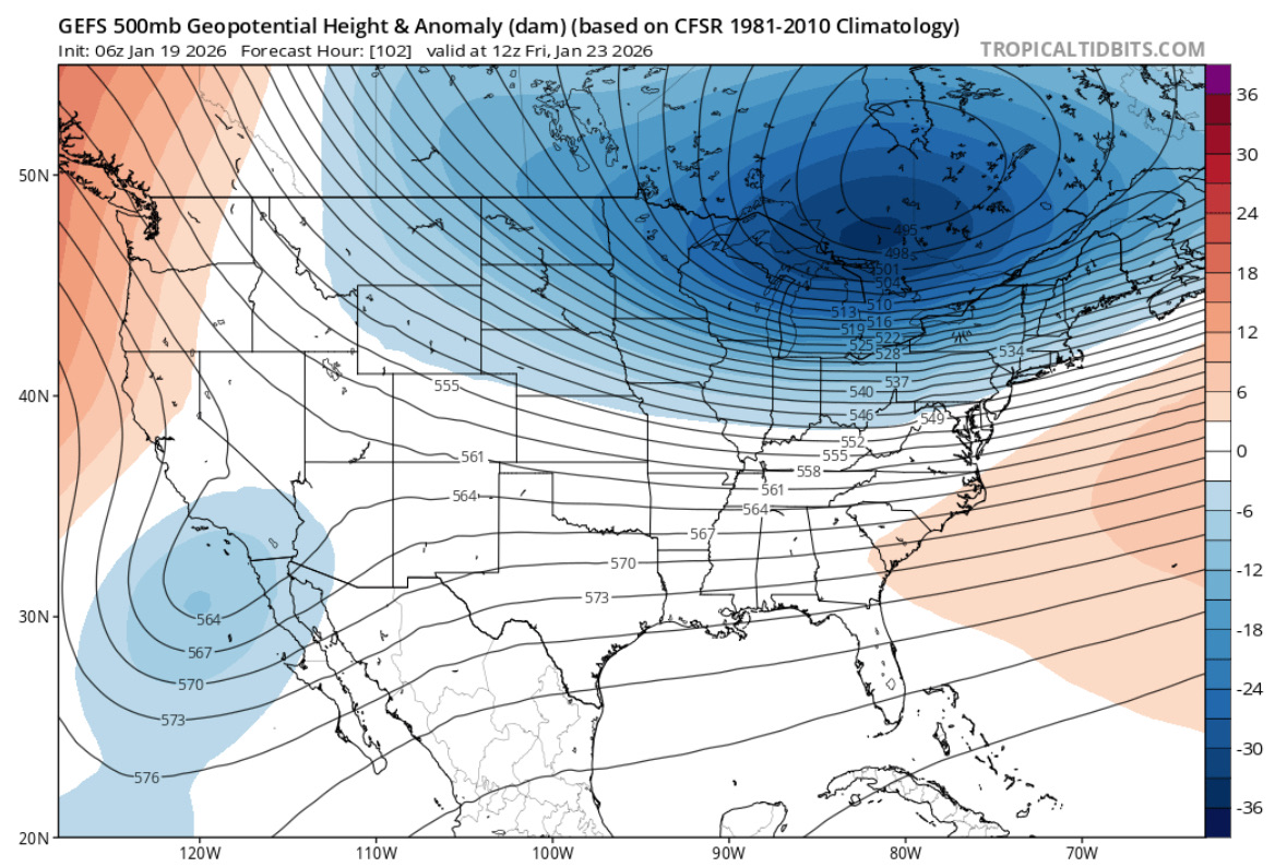
Icon is improved. Less confluence.
.thumb.png.b7d2380b71b74ec27879fcab4d5a8178.png)
-
Definitely. Especially given that we got every solution on the table, from cutter to suppressed.
-
I'd definitely try this time lol.
-
ICON is a huge improvement. Moved towards the AI models. Game tiem!
-
Icon is improved. Less confluence.
.thumb.png.2d2724f0082f2eecdf28b19d4742c54b.png)
-
.thumb.png.4150b06c63a21f61052e47a612bf1818.png)
January 2026 regional war/obs/disco thread
HIPPYVALLEY replied to Baroclinic Zone's topic in New England
Suppression threat is real.
-
Have Randy start it
-
Exactly.
-
It's a modest hit. Much better than 0z.
-
Real question is who starts the thread
-

Pittsburgh/Western PA WINTER ‘25/‘26
Rd9108 replied to Burghblizz's topic in Upstate New York/Pennsylvania
Thats dumb. There's like zero models that actually show that. AIs show a decent hit but other than that the operationals are all south. -
Icon minor hit. Most of the energy gets left but pushed out more this run to get a small hit.
-
actually, yeah, you're right. I thought it was coming all out...
-
Yep, doesn't bring it all across like the Euro, but certainly a step in the right direction. I call that a win.
-
I’m not banking on any model. None have done well
-
Its decent... but better for C VA and S VA at 138
-
If we’ve got a storm thread and we’re rocking later this week we should get a DC crew meetup for a real happy hour Thursday or Friday…
-
Man, in a few years, I would absolutely LOVE for you to be my teacher. That would be amazing.
-
Yeah, the S/W definitely coming all out...doesn't look as suppressive, but still can't say if it's coming right for us
-
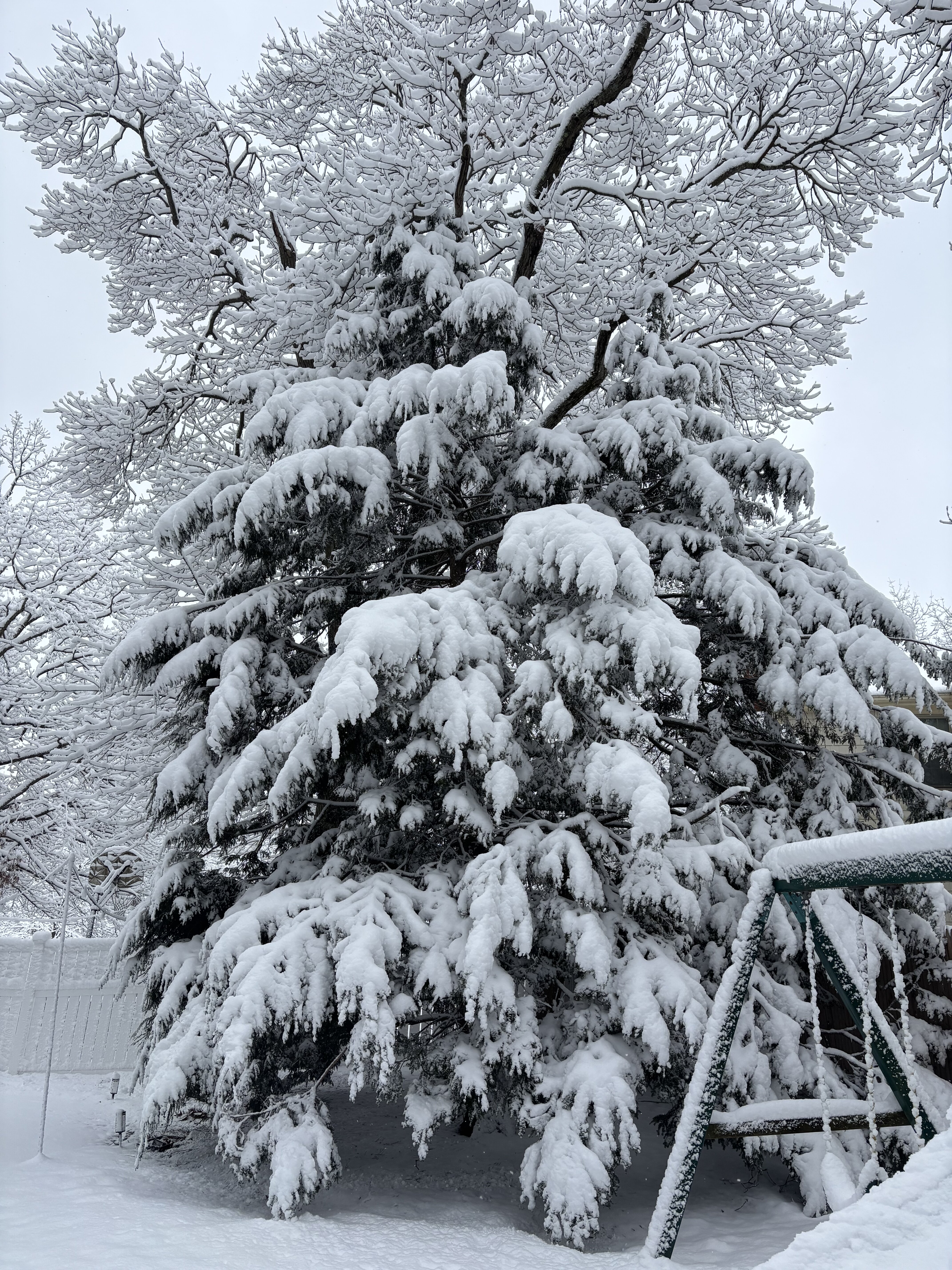
Wtfffff there’s no way. I got maybe an inch yesterday total on top of the 3” from Saturday. JFC
-
Ya not as bad but still looks like cut off gets stuck.
-

Storm potential January 17th-18th
ILoveWinter replied to WeatherGeek2025's topic in New York City Metro
Yep I measured around 2 right near the park -
OT, but the way you wrote this and provided the source credit is a testament to your writing skills and what you’ve been learning in school. Absolutely impressed. Please keep up with your scholastic work and never ever stop learning. If you ever wanted to be a meteorologist, I’d love to become a mentor for you. You have a lot of positive attributes that you should be damn proud of for being in 9th grade. Major kudos. Now back to the regularly scheduled hemming and hawing over models at 5-7 day leads
-
(002).thumb.png.6e3d9d46bca5fe41aab7a74871dd8af8.png)
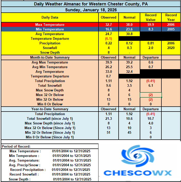
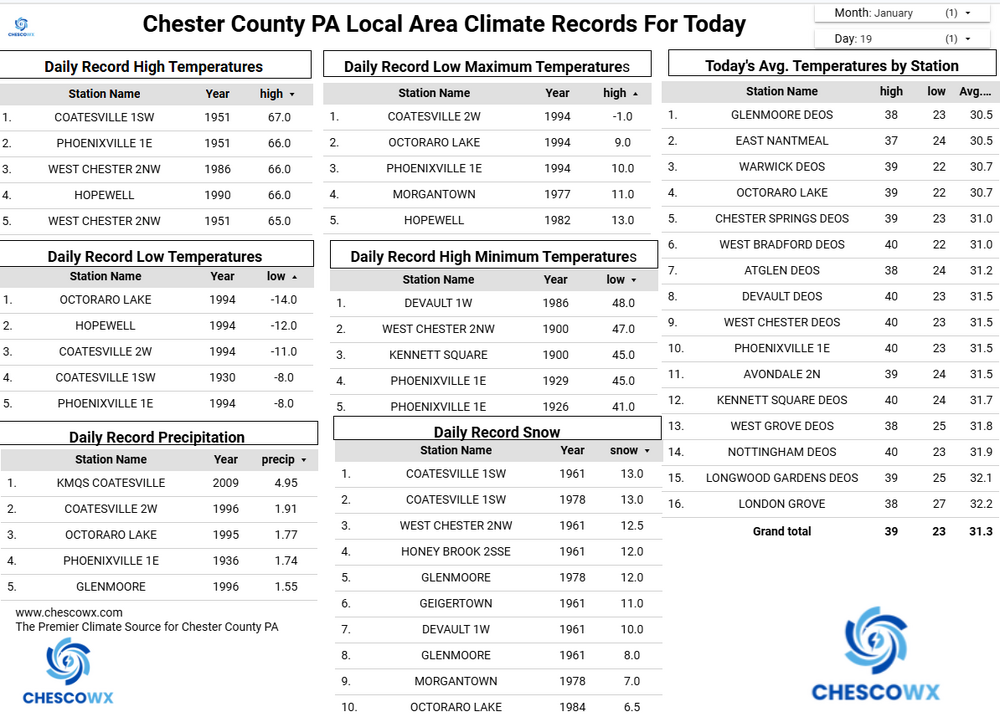
Central PA Winter 25/26 Discussion and Obs
ChescoWx replied to MAG5035's topic in Upstate New York/Pennsylvania
A prolonged stretch of well below normal temperatures are likely across our area for at least the next 2 weeks. In fact, with the exception of Thursday where temperatures will moderate to above normal (around 40 degrees) we may not see another day this month with afternoon high temperatures above freezing. Temperatures tonight should fall to near 10 degrees with highs tomorrow struggling to top 20 degrees. Temperatures by Wednesday morning will be close to zero in the typical colder valley locations. Even colder weather moves in by the weekend with high temperatures on Saturday remaining around the mid-teens with lows by Sunday morning again near zero. Our next chance of snow looks like it will be possible toward the end of next weekend.