All Activity
- Past hour
-
you hiking up or driving.? Either is fun though with great views
-
Have you got out yet? Got a tee time for noon at highfields on Sunday. I know it's very unlikely and it's a hike for you but I thought I'd throw it out there.
-

2025-2026 ENSO
40/70 Benchmark replied to 40/70 Benchmark's topic in Weather Forecasting and Discussion
Yea, usually the cool phases last a bit longer....it could spill into the next decade a bit...but it won't be as extreme....long term trend line will def. be lifting. -
We have to be at a wedding in Beverly on Friday, I’d appreciate if any of the Mets chimed in about how they think the day will go with regards to weather and rain for that area.
-
Yeah, the knife edge is insane.
-
Theirs no easy trail up to the summit.
-
74 / 56 no install tonight. Tomorrow looks hot but after that the step down begins. Leaves are already looking leathery.
-
Rolled in to the driveway at 7 and it was 68. Gotta love the PM sea breeze factor. Still haven’t installed yet.
-
Yeah I use MVL, took home the local heat award at 89F for max. That site can do it on these dry heaters. Local neighbor’s PWS was 87F though. BTV with 88F MPV with 87F. Already down to 72F MVL, 70F PWS. Those low dew afternoons drop fast once the sun starts lowering.
-
Stick to country singers homie.
-
Dews in the mid/upper 30s in June!!!! Feels like living on borrowed time but I’ll take it. Air quality finally improved as the AQI is down around 60.
- Yesterday
-
Won’t need to wear any clothes!
-
If the NAM 3km and the RRFS come to true, could be worth trying to chase either day. Still not completely sold on the overall setup but something to to continue to watch for over the next day or two. Could be the last push for the Mid-South for awhile.
-
80.4 here. Smoke FTL
-
Pretty sweet evening.
-

Chester County PA - Analytical Battle of Actual vs. Altered Climate Data
chubbs replied to ChescoWx's topic in Climate Change
I do have proof. I have showed it to you over and over again. It's the raw data from Coatesville or West Chester and other stations, before and after the moves. There is no need to guess or handwave. The raw data allows the effect of the moves to be determined very accurately. Per chart below the 1946 and 1947 moves cooled Coatesville relative to West Chester and Allentown (ABE). Before the moves Coatesville was close to West Chester. After the moves it was much closer to ABE. I have just pulled and plotted a few stations. NOAA's software checks thousands of stations. So there is much more proof available than what I have shown here. There could be tens or hundreds of stations that shed light on the Chesco moves. Your post demonstrates that you don't understand what NOAA does. There's nothing arbitrary about it. The raw data alone determines all the adjustments. Only stations that change their position relative to other stations get an adjustment. In the case of the big moves at Coatesville and West Chester the move effect is so large, roughly 2F, that it is impossible to miss. Very clear in the chart below.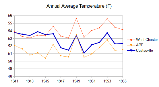
-
2nd warmest reading of the year today. Flaccid in the temp dept.
-
That’s Ineedsnow weather. Here cheers for that.
-
85.2° for the high here.
-
Yesterday was hotter for me, I had the A/C on at 6 pm. Today, no A/C needed.
-
that offshore storm is going to delay the frontal passage. Saturday morning should be okay.
-
wow that 1821 gale hit both Norfolk and Long Island (hence the name). I wonder where this made landfall on Long Island?
-
Seems like highs were around 70-71 on the barrier islands, was 81-82 at my house. I’ve seen much bigger gradients this time of year-20 degrees or more.
-
No rain Friday, it will be at least partly sunny on Friday
-
Tomorrow will be the hottest day so far in parts of the region. Parts of the region could reach 90° for their first time this year. Temperatures will remain above normal into the weekend when high temperatures will return to the 70s. Showers and thundershowers are possible during the weekend. Rainfall amounts should generally be light except where scattered locations see heavier thunderstorms. The ENSO Region 1+2 anomaly was +0.2°C and the Region 3.4 anomaly was -0.2°C for the week centered around May 21. For the past six weeks, the ENSO Region 1+2 anomaly has averaged +0.08°C and the ENSO Region 3.4 anomaly has averaged -0.08°C. Neutral ENSO conditions will likely continue through at least mid summer. The SOI was +11.32 today. The preliminary Arctic Oscillation (AO) was +1.773 today.


.thumb.png.4150b06c63a21f61052e47a612bf1818.png)


.thumb.jpg.049f4a7f726ada07e8cd30bd17e713cb.jpg)


