All Activity
- Past hour
-

July 2025 Discussion-OBS - seasonable summer variability
psv88 replied to wdrag's topic in New York City Metro
62 this morning. So it looks like no 50s this July. A few 62s but that’s as long as it got -

July 2025 Discussion-OBS - seasonable summer variability
bluewave replied to wdrag's topic in New York City Metro
I posted this the other day. Only a very small area around San Francisco has seen the cooler temperatures. Fits the recent theme of the cooler areas covering much less real estate against the record warmth in the Northern Hemisphere this summer. -

July 2025 Obs/Disco ... possible historic month for heat
TheClimateChanger replied to Typhoon Tip's topic in New England
Wow, in a stunning reversal from the high heat and humidity, Saranac Lake dropped to 34F, tying its daily record low set in 1914. The all-time record July monthly record low in the Saranac Lake threaded record is 29F, set on July 8, 1919. At the airport site, the all-time record low is 32F, which has been set on more than one day, last on July 28, 2001. Of note, the US Climate Reference Network station at Millbrook 3W in Dutchess County fell to 32F yesterday. The all-time observed record low for the month of July in the state of New York is 25F, which was set at Allegany State Park, in Cattaragus County, on July 8, 1963. -

July 2025 Obs/Disco ... possible historic month for heat
Great Snow 1717 replied to Typhoon Tip's topic in New England
..but down south people can enjoy the summer weather for many months longer than in SNE....perhaps a AMWX southern commune in the future??? -

2025-2026 ENSO
40/70 Benchmark replied to 40/70 Benchmark's topic in Weather Forecasting and Discussion
So you kind of had the right idea. There were some pretty fundamental differences from 2010-2011 beyond simply 14 years worth of GW. -
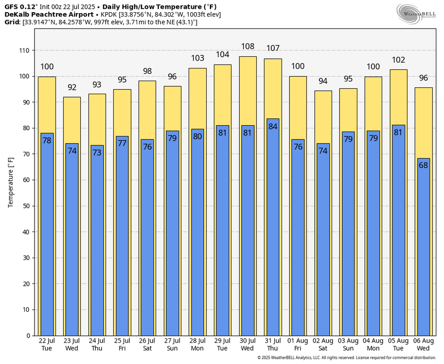
Based on the quotes I copied below from June showing the GFS as having verified as being much too hot for highs, the 0Z 7/22 GFS will almost certainly verify as too hot and likely much too hot for highs as the hottest at ATL was 95 on 6/24 and 96 on 6/25. First, here’s the laughable 0Z 7/22 GFS for KATL (0Z Euro is much cooler with hottest highs of “only” 99 on 7/30 and 101 on 7/31 and will likely come much closer): highs of 100 today vs FFC’s forecast of 96, 103 on 7/28, 104 on 7/29, 108 on 7/30, and 107 on 7/31 (Keeping in mind that FFC was almost spot on for the late June heat by being much cooler than the GFS, FFC’s forecast hottest through 7/29 is only mid 90s): Second, here are quotes of two posts I made elsewhere in late June showing the way too hot GFS progs for late June highs: “KATL is also looking brutal on the 6Zs this week with these highs: (GFS/Euro) 6/22: 96/91 6/23: 99/95 6/24: 103/102 6/25: 101/104 6/26: 94/96 6/27: 96/87 Currently FFC has ATL’s hottest on 6/25 with upper 90s, but they’re watching closely.” and ”Which did better today for highs, GFS or Euro? 6Z GFS/Euro highs today for: RDU: 103/99 vs actual of 100; Euro wins GSO: 101/100 vs actual of 95; both were terrible though Euro less terrible FAY: 99/99 vs actual of 98; both did well ATL: 102/98 vs actual of 95; Euro did better than the awful GFS but still was 3 too hot Euro also did better yesterday at GSO and FAY So for these 2 days overall, Euro did significantly better than GFS, which tended to be at least several degrees too hot.”
-

July 2025 Discussion-OBS - seasonable summer variability
Brian5671 replied to wdrag's topic in New York City Metro
someone said once "the coldest winter I ever spent was summer in San Fran" -
I linked it up yesterday showing that the mismatch analogs would be colder than what the Euro was forecasting for last winter. But in this warmer climate they probably wouldn’t be as cold as previous mismatch years. That turned out to be correct since last winter was one of the warmest on record for past instances when those parameters were met back in the colder climate.
-
2025-2026 ENSO
40/70 Benchmark replied to 40/70 Benchmark's topic in Weather Forecasting and Discussion
I got down to 49.1...it was so refreshing. -
2025-2026 ENSO
40/70 Benchmark replied to 40/70 Benchmark's topic in Weather Forecasting and Discussion
All joking aside, I will try be more mindful of seeking clarity from you in the future before passing judgement...not that you are about my take. -
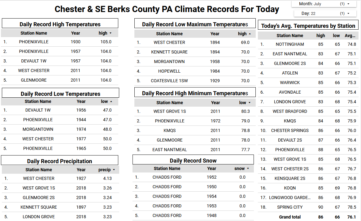
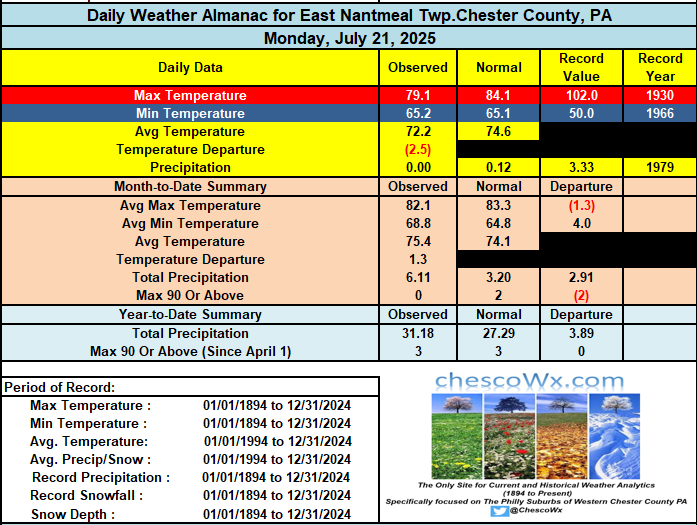
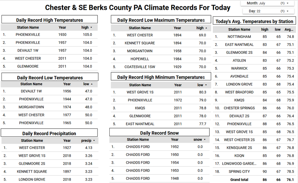
Low temperatures this morning ran between 5 and 7 degrees below normal for late July. The lowest I found was the 55.1 degree reading at Warwick Township. Another beauty of a day today with highs ranging from the upper 70's at higher spots to the low 80's in valley locations. We start a warming trend back to near normal on Thursday and then above normal temperatures by Friday with some spots cracking 90 degrees for the first time in more than a month. Shower chances return over the weekend.
-
A wonderful early fall-like morning.
-

E PA/NJ/DE Summer 2025 Obs/Discussion
ChescoWx replied to Hurricane Agnes's topic in Philadelphia Region
Low temperatures this morning ran between 5 and 7 degrees below normal for late July. The lowest I found was the 55.1 degree reading at Warwick Township. Another beauty of a day today with highs ranging from the upper 70's at higher spots to the low 80's in valley locations. We start a warming trend back to near normal on Thursday and then above normal temperatures by Friday with some spots cracking 90 degrees for the first time in more than a month. Shower chances return over the weekend.
-
2025-2026 ENSO
40/70 Benchmark replied to 40/70 Benchmark's topic in Weather Forecasting and Discussion
Great, could you link me to your seasonal temp forecast for last winter? -
Actually, Graham had heavy rains from not one but two TCs in Sept of 1999: -6.36” Sept 5-7 from Dennis -4.30” Sept 15-17 from Floyd In addition, they had 5.12” Sept 27-30 from I don’t know what (no named storm then). https://www.weather.gov/wrh/Climate?wfo=rah
-
There would be no confusion if you asked me yesterday since I keep a record of which days they were posted on. Like…Hey can you direct me to your forecast ideas from last winter? I would have said sure and directed you to the posts from last October. My snowfall outlooks were in the NYC Metro forum.
-

2025-2026 ENSO
PhiEaglesfan712 replied to 40/70 Benchmark's topic in Weather Forecasting and Discussion
Yeah, I really don't care about a record high temperature in Montana. It has no bearing on our area. There were a lot of record high temps in Montana during January, February, and March 2015. It's not going to take away from the fact that it was the coldest JFM since 1978 where I live. Or the fact that Montana had a +10 temp departure last December. Temps were near normal last December in my area, and it was the coldest winter of the last 10. -

July 2025 Obs/Disco ... possible historic month for heat
tamarack replied to Typhoon Tip's topic in New England
43° of fake cold here. Yesterday's max of a sunny 66 wasn't fake. -

July 2025 Obs/Disco ... possible historic month for heat
bristolri_wx replied to Typhoon Tip's topic in New England
This is a first, @Damage In Tolland arguing with @Torch Tiger on cooler vs warmer conditions.
-
Beautiful morning for a walk....less humid but still pretty warm in the strong July sun....
-
None. If there is a record high temp in bumble Montana, we will 100% see a post in the NY forum about it. A few record lows last night across NE, silence. Zero chance this guy would have been too cold.
-
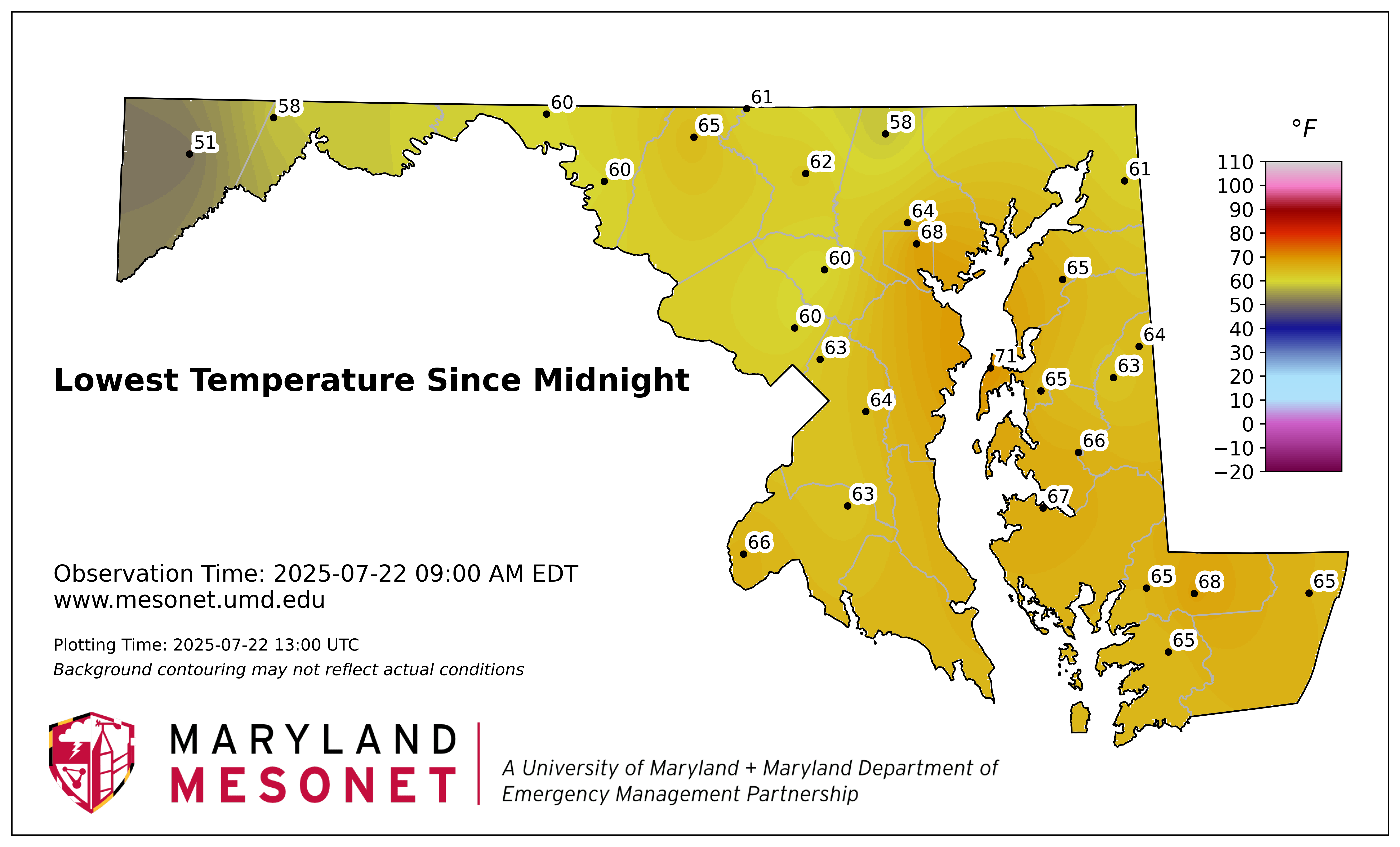
Can't complain for July 22nd. The lower dew points didn't sink as far south as I expected.

-

July 2025 Discussion-OBS - seasonable summer variability
SACRUS replied to wdrag's topic in New York City Metro
Records: Highs: EWR: 108 (2011) NYC: 104 (2011) LGA: 104 (2011) JFK: 103 (2011) Nw Bnswck: 102 (1980) Lows: EWR: 56 (1944) NYC: 58 (1890) LGA: 62 (1956) JFK: 59 (1966) New Bnswck: 51 (1944) Historical: 1918 - A single bolt of lightning struck 504 sheep dead in their tracks at the Wasatch National Forest in Utah. Sheep often herd together in storms, and as a result the shock from the lightning bolt was passed from one animal to another. (David Ludlum) 1926: State maximum temperature record was set today at Troy, New York which was 108 °F. Also the maximum temperature of 105 °F was recorded at Waterbury, Connecticut but their state record is now 106 °F in 1995. (Ref. Lowest and Highest Temperatures for the 50 States) 1959: Two one-hundredths of an inch of rain was recorded ending a streak of 150 days with no measurable precipitation at Las Vegas, NV. (Ref. Wilson Wx. History) 1972: One person in Virginia was killed by lightning while playing softball. (Ref. Lightning - Virginia Weather History) 1986 - Hurricane Estelle passed 120 miles south of the Hawaiian Islands creating a ten to twenty foot surf. The large swells resulted from a combination of high tides, a full moon, and 50 mph winds. The hurricane also deluged Oahu Island with as much as 6.86 inches of rain on the 24th and 25th of the month. (Storm Data) 1987 - Barrow, AK, receives 1.38 inches in 24 hours on the 21st and 22nd, an all-time record for that location. The average annual precipitation for Barrow is just 4.75 inches. Thunderstorms in Montana produced 4 to 6 inches of rain in Glacier County causing extensive flooding along Divide Creek. Missoula, MT, received 1.71 inches of rain in 24 hours, a record for the month of July. (The National Weather Summary) (The Weather Channel) 1988 - Six cities in the south central U.S. reported record low temperatures for the date, including Pueblo, CO, with a reading of 48 degrees. Thunderstorms over the Atlantic Coast Region drenched Wilmington, NC, with 6.49 inches of rain in about eight hours. (The National Weather Summary) 1989 - Showers and thunderstorms prevailed across the southeastern third of the country. Afternoon thunderstorms in Florida produced wind gusts to 86 mph at Zephyrhills, and gusts to 92 mph at Carrollwood and Lutz. Thunderstorm winds gusting to 69 mph at Crystal Lake damaged nineteen mobile homes. (Storm Data) (The National Weather Summary) 1992: Lightning hit on or near a concrete mixing truck near Walla Walla, WA; a man was knocked off the truck. 10 minutes later a 2nd strike knocked him away from the truck again. He was fortunate he was only slightly hurt. (Weather Guide Calendar with Phenomenal Weather Events 2011 Accord Pub. 2010, USA) 1993: The levee, holding back the flooding Mississippi River at Kaskaskia, Illinois, ruptures, forcing the town's people to flee on barges. The incident at Kaskaskia was the most dramatic event of the flood. At 9:48 a.m., the levee broke, leaving the people of Kaskaskia with no escape route other than two Army Corp of Engineers barges. By 2 p.m., the entire town was underwater. 1999: The Cedar River in Charles City, IA reached its all-time crest of an estimated 22.8 feet. Approximately 100 homes had flood damage in Charles City. Almost 12 inches of rain fell in a 48 hours period over these counties. Rainfall totals that day: New Hampton, IA: 7.10 inches (wettest day on record), Charles City, IA: 6.65 inches, West Union, IA: 4 inches. (Ref. Wilson Wx. History) 2003: "The Mid-South Derecho of 2003" States affected....AR, TN, MS, AL, GA, SC (Ref. For More Information) 2006: Palm Springs, California: Mercury soars to 121 °F. (Ref. WxDoctor) 2006: Widespread damaging winds, estimated around 90 mph, raked most of Jefferson County in south central Illinois. The city of Mt. Vernon was especially hard hit, where about 14% of all homes received at least minor damage. In Mt. Vernon, damage assessments indicated 1,107 homes were affected by some type of damage. 491 homes received minor damage such as roofs blown off, 152 received major damage, and 18 were destroyed. (Ref. Wilson Wx. History) 2011: A low of 82 degrees Fahrenheit on the 22nd at Norfolk tied for the second highest minimum temperature ever recorded there. Also the highest temperature for 2011 was 103 °F at Norfolk and 102°F at Richmond both on July, 22nd. (Ref.NWS, Wakefield, Virginia - A Near Record High Minimum Temperature for Norfork) -
64/63 for my low.
-
July 2025 Discussion-OBS - seasonable summer variability
Brian5671 replied to wdrag's topic in New York City Metro
turned off the AC here for the day-give it a rest and let some fresh air in-69 and breezy right now