All Activity
- Past hour
-
Looks like we miss out on at least some isolated thunderstorms tomorrow night...looks to be back over PA. Looks to be associated with the approaching warm front and some decent lapse rates/elevated instability. Nice theta-e ridge too. Maybe some upslope snows though for the southern Greens?
-
Is it because that is intended to be an overlay layer and the gray checkerboard area is transparent and so it can render overtop another background layer?
-

Central PA Spring 2026 Discussion/Obs Thread
canderson replied to Voyager's topic in Upstate New York/Pennsylvania
Happy Patriots’ Day -
I’ve got a coating of snow on the grass and deck on the Ring cams at McHenry. 80 this past Saturday to snow lol
-
tonight looks cold and area wide freezes except probably in the city!
-
In 2025, "last freeze" dates at DCA/IAD/BWI: DCA: March 3 IAD: April 9 BWI: April 9
-
I like the ens member with a high of 35° on May 1st
-
Tomorrow morning should be colder and heavier frost. Op Euro is still dry here through the first week of May
-
After today and tomorrow the patterning looks like 10 days ( to start ...) of persistent nondescript neutral Ts... with 'tendencies' along the way for BN. It's just that typical model regression in mid spring tends to oversell cold looks in the mids and extended ranges. Then combining that bias with "some kinda" coefficient CC forcing from the background state, together probably helps to suspend closer to neutral. It's just harder to sustain below normal then it used to be decades ago. The -NAO is looking pretty weak in the operational runs... tending to limit the physical manifestation of that index state by being both inconsistent with the magnitude of actual ridging up there, but also ranging placement between the western and eastern limb. Which matters... east would allow warmer hgts to creep farther N over the mid latitude continent. I.e., maybe not as bad for warm enthusiasts here after all. West variant, however, during a flaccid slackening gradient would probably cut off lows near Cape Cod and really ratchet up the Count Rugen torture. That said, there's still something of it there. Because the behavior of transits; having trouble getting N of our latitude is -NAO suggestive. Some amount of suppression is modeled nonetheless.
-
Got the charts for CON?
-
DGW
-
Sping! (Sp)some understand
.thumb.png.bdb435faaccf5a8c27b2a7b35ac903f1.png)
-
Warnings for an upcoming freeze all across the region. Only SE Virginia is spared, and of course the mountains don't get freeze warnings yet. ((Sorry for those who might have thought Tax Day signalled "safe to plant" starting time for tender stuff.))
-

Central PA Spring 2026 Discussion/Obs Thread
Mount Joy Snowman replied to Voyager's topic in Upstate New York/Pennsylvania
Low of 37 and .26” of rain brings the two-day total to .49”. Could see 20s tonight. -
55° and sun keeps feeling better right into June

-
Let’s get this to verify
-
Light snow and 36 at Pen Mar
-
Weren’t we told frosts are done at DAW?
-
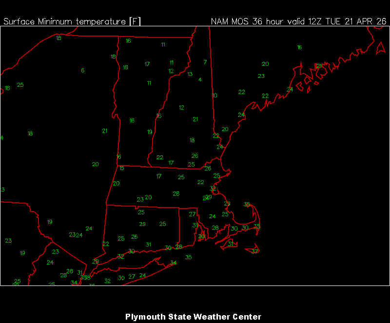
30.0⁰ low this am
- 706 replies
-
- 1
-

-
- april showers bring may..
- rain
- (and 2 more)
-
Late to this conversation but A+ in Charlotte with two storms and a foot of snow from one of them. B- in Ashe County - lots of dusting as and 1” events but the only really good storm was the snowstorm and we were on the wrong side of that.
-
Fairly stout snow shower moving through this morning. No accums in mby but traffic cams up at 68/219 show some non-road accumulations. LWX notes in their disco that the growing season hasn't started out here yet but there sure is a lot of greenery from the warm spring. Tonight will be interesting to see how cold it gets given the green up.
-
Def would need a -WPO to help bring down arctic air in concert with the strong STJ but who knows at this point
- Today
-
We were just hanging out in the neighborhood commenting on how nice it was when I realized we were actually -5 on the high.
-
Only 2 months away. In the meantime we rationalize 50s and sun as being nice spring days.


.png.4015bff9d207483ef2e63a4d34b27f50.png)
.png.6b359971b3abf23c6924dbf6df0807c7.png)


.png.1431cce1ce296ab1a5394288c5d36980.png)


.thumb.JPG.418e8a9a2902ae687ec35ff4bc0e038e.JPG)

