All Activity
- Past hour
-

2026-2027 Strong/Super El Nino
snowman19 replied to Stormchaserchuck1's topic in Weather Forecasting and Discussion
-

2026-2027 Strong/Super El Nino
LakePaste25 replied to Stormchaserchuck1's topic in Weather Forecasting and Discussion
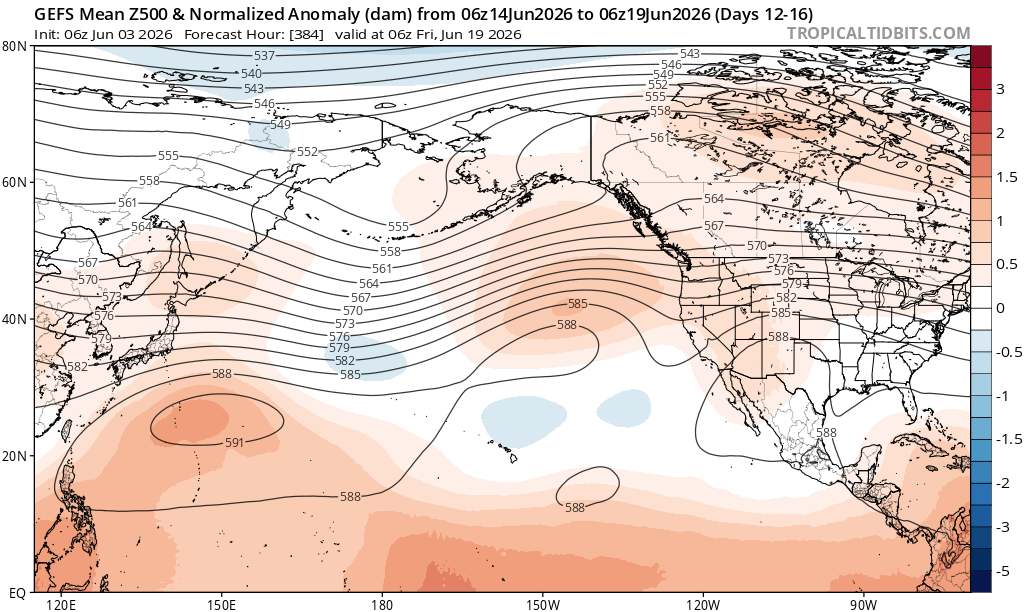
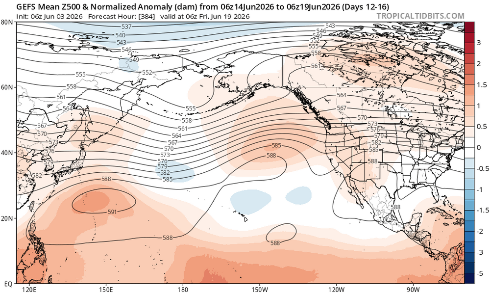
I think this is manifesting as a weakened mid latitude cell via destructive interference. The westward leaning convection results in downstream mid latitude trough, which then results in subsidence downstream of the trough. Where the subsidence is occurring, it competes with where we expect a mid latitude trough from Nino influenced convection over the equator. So the end result is generally a weakened aleutian low as it must compete from subsidence caused by upstream troughing. The long range GEFS starts to bring these troughs closer together, more of what we’d expect in a Nino with a broad mid latitude cell extending east of the dateline.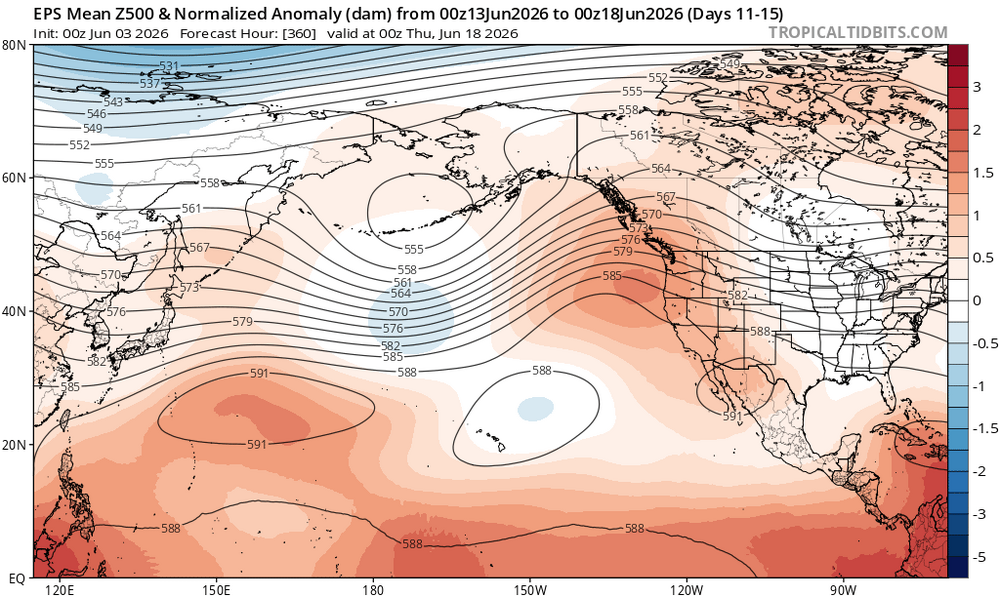
-
And then, we go right back to potential near record heat by the 12th-13th according to some of models.
-

2026-2027 Strong/Super El Nino
Stormchaserchuck1 replied to Stormchaserchuck1's topic in Weather Forecasting and Discussion
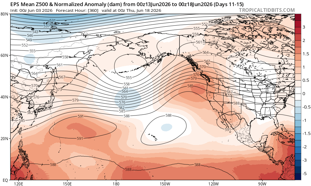
Models continue building a Strong Aleutian ridge in the long range -
39F to 67F by 9:40am. Fast recovery.
-
Low of 57. Wind kept up most of the night which kept us from bottoming out. Chilly walk this morning with the wind.
-

2026-2027 Strong/Super El Nino
GaWx replied to Stormchaserchuck1's topic in Weather Forecasting and Discussion
I also have 6 +QBO/Nino Decembers since 1980: 1982, 1987, 1994, 2006, 2015, 2018 I’m counting the barely positive QBOs of 1997 and 2004 as neutral QBO. Otherwise there’d be 8. The only one of the 6 that wasn’t warm in the E US was 2018, which was NN to slightly AN in the E US. So, it appears to be a pretty good correlation although the sample size is pretty small. Aside: Today’s SOI was the most negative so far this year at -34.80. -
wtf... Firing Pelley from 60-Minutes is like dynamiting the face of Lincoln off the Rushmore of news journalism. CBS? no shit - You know, this, coming so soon after the Colbert debacle. And that bullshit with Trump instructing them a couple years ago and they all but happily obliged. All of which stinks to high heaven of an organization where you 'say what we want you to say else we'll fascistly wield our will' In an idealistic vision, civility en masse boycotts anything that has CBS finger prints anywhere around it or on it, and points their TV and devices toward different antennas. Let CBS' valuations deteriorate right before the kuntitudinal eyes of the organization's leader. It just folds. That's a flux of unemployment I would be just tickled pink in joy knowing was happening. Then, set some other news/entertainment organization journalism on an ongoing investigation into the lives of all those upper management and exec ranked assholes, showcasing their travails in trying to find a toe-hold on anything in a society that knows what they're really about. Welcome to the deserved sewer of society you pieces of shit.
-
I thought bears shit in the woods.

-

2026-2027 Strong/Super El Nino
bluewave replied to Stormchaserchuck1's topic in Weather Forecasting and Discussion
I use it now along with the climate reanalyzer for composites We can see why many have been noticing that despite the record developing El Niño, the sensible weather is more Niña-like. Record 100° heat a few weeks ago and the 90s reloading in a few days is probably reflecting the westward lean of the Nino forcing. The cooler days in between are probably more of a Nino-like influence with the recent snows in the New England higher elevations.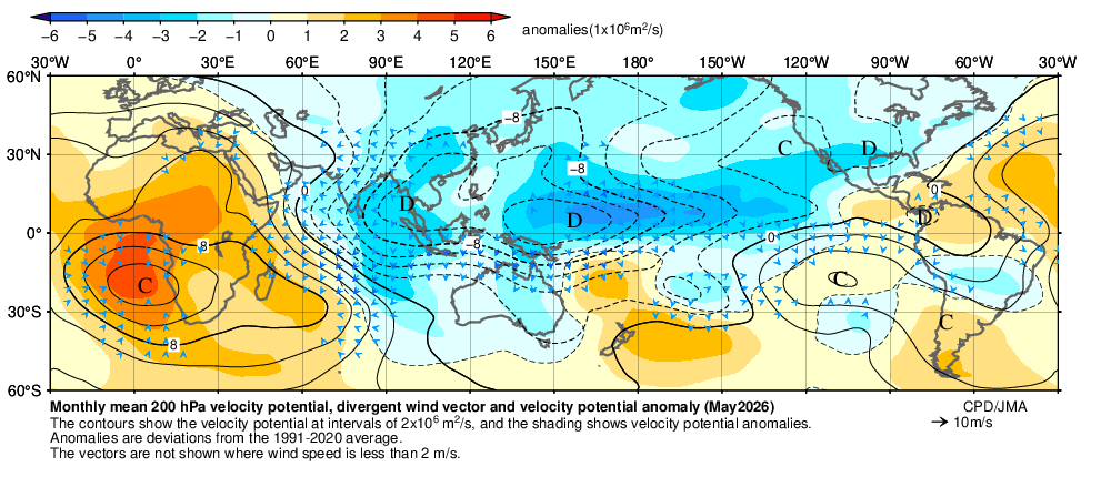
-
Looking pretty dry moving forward.
- Today
-
Heh... reminds me of that meme years ago. Very large aquarium wall, 4" of transparent aluminum glass on the other side of which this giant fluffy polar bear yawns and lazily slides off some prop for rocks and submerges itself in water sloshing like a fat kid in a bath tub. The crowd of 4 to 8 year old onlookers together with their skyscraper moms and dads are in unison, oohs and ah chorus at this specter... Just then, the bear's paddling front feet make it look deliberate as it rotated it's equally giant ass axis pointed directly down the collective line of sight of said crowd, whereby it proceeded to all but instantly transform the clarity of the water into this putrid colored anal pall. Beige ass vomit burst forth like that blow out scene in the film "Deep Horizon"... looked remarkably similar in color to that image above. The chorus of ooh and ahs resolved the note of their song in something like ewes and oophs. Put that in your children's book. Welcome to nature, kid -
-
Dang! Just think, in only about three and a half to four months, we will again regularly have lows in the 40s
-

Junorch obs and discussion 2026
Damage In Tolland replied to Damage In Tolland's topic in New England
They always do. Just like Father Time.. dewy’s undefeated -
Those plumes from the rivers can go a long way… like when we have a good flooding event you’ll have folks out motoring around in boats thinking it’s nice, clear open water and run into a plume filled with debris and whole trees floating around in the lake. Nothing like hitting a tree trunk at 40mph in a boat out in the middle of no where.
-
Records: Highs: EWR: 94 (1943) NYC: 95 (1895) LGA: 93 (1943) JFK: 88 (2010) Lows: EWR: 45 (1946) NYC: 45 (1929) LGA: 49 (1946) JFK: 48 (1946) Historical: 1860: Iowa's infamous Camanche Tornado, likely an F5 storm, kills 92 and injures 200. Every home and business were destroyed. It was one of the most damaging families of tornadoes ever to strike the US and resulted in more farm fatalities than any other tornado except for the Tri-State tornado. 1860:Several tornadoes struck northern Illinois killing 100 people and injuring 220 others. The death toll included 23 people on a raft which was destroyed as a tornado moved across the Mississippi River. The twisters destroyed numerous businesses and farms and even threw several homes into the Mississippi River where 10 occupants drowned. (Ref. Wilson Wx. History) 1887: A tornado or waterspout touched down on the Wabash River, about 5 miles north of its mouth with the Ohio River. Three people drowned when a boat was overturned at Old Shawneetown. (Ref. Wilson Wx. History) 1921 - A cloudburst near Pikes Peak CO killed 120 people. Pueblo CO was flooded by a twenty-five foot crest of the Arkansas River, killing 70 persons. Fourteen inches of rain was reported at Boggs Flat, where a hard surface road through nearly level country was washed out to a depth of seven feet. (The Weather Channel) 1921: Heavy rains caused flash flooding over the southeastern portion of Colorado. The flooding cost the lives of 100 people and millions of dollars in property damage. 1951: Sheridan, WY dropped to 27°; their coldest June temperature on record. Denver, CO received a trace of snow. (Ref. Wilson Wx. History) 1959 - Thunderstorms in northwestern Kansas produced up to eighteen inches of hail near Salden during the early evening. Crops were completely destroyed, and total damage from the storm was about half a million dollars. Hail fell for a record eighty-five minutes. The temperature dropped from near 80 degrees prior to the storm to 38 degrees at the height of the storm. (David Ludlum) 1987 - Six days of flooding in South Texas culminated with five to six inch rains from Bexar County to Bandera County, and five to nine inches rains in Gonzalez and Wilson Counties. Total crop damage was estimated at 500 million dollars. (Storm Data) (The National Weather Summary) 1988 - Early morning thunderstorms in southern Texas produced wind gusts to 86 mph at Port Isabel, and wind gusts to 83 mph at South Padre Island. Unseasonably hot weather prevailed from the Southern Plateau Region to the Northern High Plains. Fourteen cities reported record high temperatures for the date. (Storm Data) (The National Weather Summary) 1989 - Thunderstorms developing over the Southern Plains Region during the afternoon hours produced severe weather into the night. Thunderstorms spawned eleven tornadoes, and there were 169 reports of large hail and damaging winds. Thunderstorm winds gusted to 80 mph at Newcastle, OK, and Wilson, OK. Softball size hail was reported at Monahans, Childress and Groesbeck TX. Monahans TX reported six million dollars damage. Five inches of rain deluged Geronimo OK. (The National Weather Summary) (Storm Data) 1993: Early morning severe thunderstorms dumped huge hailstones across northern Oklahoma. Hail, up to 6 inches in diameter in Enid, went through roofs of homes, damaged three jets at Vance Air Force Base, and did $500,000 in damage at a car dealership. Winds gusts reached 70 mph at Vance Air Force Base as well. Hail damage to the wheat crop was estimated at 70 million dollars. 1995: Nottoway County, VA - A man suffered second degree burns when lightning struck him as he stood near an outside basement entrance. (Ref. Lightning - Virginia Weather History) 1997: It was a chilly day in the East. The high temperature at Philadelphia International Airport, PA was only 59°, tying a record-low maximum for the date set back in 1881. The mercury at Middletown, PA only rose to 58°, breaking the record-low maximum for the date of 59° set back in 1915. Washington, DC only reached 58°, breaking the old record-low maximum of 59° set back in 1915. At Williamsport, PA, the high temperature of 52° tied the old record-low maximum, which was set in back in 1945. Central Park in New York City only reached 61°. (Ref. Wilson Wx. History) 1997: It was a chilly day in the East. The high temperature at Philadelphia International Airport was only 59 degrees, tying a record-low maximum for the date set back in 1881. The temperature at Middletown, Pennsylvania rose to 58 degrees, breaking the record-low maximum for the date of 59 degrees set back in 1915. Washington, DC only reached 58 degrees, breaking the old record-low maximum of 59 set back in 1915. Central Park in New York City only reached 61 degrees. 2002: An impressive heat burst at Amarillo, TX caused the temperature to jump to 90° at 3:21 am. The heat burst was accompanied by winds of 55 mph. (Ref. Wilson Wx. History)
-
dunno. I'd a just deferred to AI on that one. Asked it to remove feces smear and re-render it before going for splendor in social media
-
70 / 46 - most to 80 after a few got there Tuesday. Warmup some heat and potential heatwace (2nd for some) Thu - Sat. Front upper low influence on Sunday. Onshore barrage next week but more So cal with it remaining dry. Once flow comes around it moderates / warms up quickly and comes with a window 2-3 days of brief but strong heat as overall ridge north and weakness below will continue through mid month. Overall near to above normal by way of short but strong warm-heat.
-
RAH referring to us as a desert now: 1) Very dry air and soil moisture levels will lead to desert-like conditions with very warm days and very cool nights into Thursday night.
-
Wow! Was not expecting that this morning. My farm dropped to 41.7 too which was in line with the Louisburg airport reading of 41. Very chilly. 50.2 here at my house so didn’t quite crack 40s but what an incredible morning walking outside
-

2026-2027 Strong/Super El Nino
LongBeachSurfFreak replied to Stormchaserchuck1's topic in Weather Forecasting and Discussion
There were allot of coastal storms and resulting erosion that winter. I was working on a research project tracking erosion at the time. Snow wise in the north east it was a lack of cold air that produced the negative result not the storm track. . -
Ha, not sure that's what that is. Lake Champlain isn't the cleanest at all, but that looks like sediment. Had 1-2" of rain over the weekend and sharply elevated rivers, probably a sediment plume flushed out from one of the larger rivers? Winnoski or Lamoille rivers need to be emptying around there somewhere depending on how he took off.
-

2026-2027 Strong/Super El Nino
40/70 Benchmark replied to Stormchaserchuck1's topic in Weather Forecasting and Discussion
JMA site is awesome, but my primary complaint about it is the inability to run composites. -
When is this nonsense going to end ? Near record highs in some locations to near record lows in a short period of time has happened a few times since April - one constant however - the drought will continue until further notice.
-
 That’s my gut feeling as well.