All Activity
- Past hour
-
 Icon north. Rgem heavier south
 -
 Another gorgeous morning! 73, cool breeze. Perfect day.
 -
Yeah we'll have to see if Erin either tries to re-strengthen some as it moves north or at least re-develops a better structure. But these two factors, particularly the later could have big impacts on what transpires across the outer banks of NC and even Nantucket. In addition to the shear and dry air you have to wonder if just sitting over the same area for so long is playing a factor too. It's even difficult to pinpoint the centers exact movement too. Almost looks like it could be more of a NNW heading but the center is also kind of jumping around a bit.
-

Hurricane Erin: 110 MPH - 958 mb - NW @ 7
yoda replied to BarryStantonGBP's topic in Tropical Headquarters
SUMMARY OF 1100 AM EDT...1500 UTC...INFORMATION ----------------------------------------------- LOCATION...25.6N 72.4W ABOUT 650 MI...1050 KM SW OF BERMUDA ABOUT 690 MI...1105 KM SSE OF CAPE HATTERAS NORTH CAROLINA MAXIMUM SUSTAINED WINDS...105 MPH...165 KM/H PRESENT MOVEMENT...NW OR 325 DEGREES AT 9 MPH...15 KM/H MINIMUM CENTRAL PRESSURE...961 MB...28.38 INCHES WATCHES AND WARNINGS -------------------- CHANGES WITH THIS ADVISORY: A Storm Surge Warning has been issued for the North Carolina Outer Banks from Cape Lookout to Duck. A Tropical Storm Warning has been issued for the North Carolina Outer Banks from Beaufort Inlet to Duck. A Tropical Storm Watch has been issued north of Duck to Cape Charles Light Virginia. SUMMARY OF WATCHES AND WARNINGS IN EFFECT: A Storm Surge Warning is in effect for... * Cape Lookout to Duck, North Carolina A Tropical Storm Warning is in effect for... * Turks and Caicos Islands * Southeast Bahamas * Beaufort Inlet to Duck, North Carolina A Tropical Storm Watch is in effect for... * Central Bahamas * North of Duck, North Carolina to Cape Charles Light, Virginia -

2025 Spring/Summer Mountain Thread
Met1985 replied to Maggie Valley Steve's topic in Southeastern States
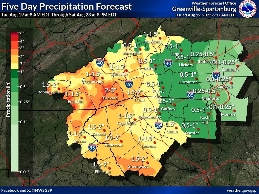
Surprise, Surprise more rain on the way. Sent from my SM-G998U using Tapatalk
-
More localized and cheaper pass option. https://snowtripleplay.com
-
Yeah the euro has some nasty winds to Cape Cod. Decent pressure gradient will form as it moves north.
-
 Here now; yesterday was washed. Today is mostly cloudy, stiff NE breeze. Kids are out on the beach, but waters too rough to swim.
 -
Walt has been noting this for the past 24hrs. I think he sniffed it out.
-

Hurricane Erin: 110 MPH - 958 mb - NW @ 7
eyewall replied to BarryStantonGBP's topic in Tropical Headquarters
11am shows a tick east in the track and windfield as it brushes by NC -
A Tropical Storm Watch has been issued north of Duck to Cape Charles Light Virginia.
-
I see they upgraded to TS warnings for Cape Hatteras but the structure of Erin is getting destroyed and everything is essentially into the eastern quadrant of the storm. I know the wind field will expand and reconfigure as Erin grows but its entirely possible they barely get to TS force winds even to Cape Hatteras.
-

2025 Lawns & Gardens Thread. Making Lawns Great Again
dendrite replied to Damage In Tolland's topic in New England
Coming soon to a yard near you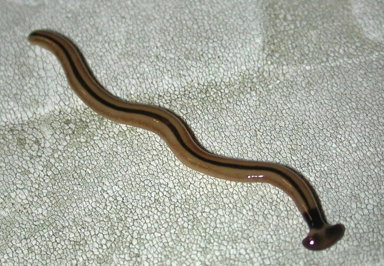
-

Hurricane Erin: 110 MPH - 958 mb - NW @ 7
olafminesaw replied to BarryStantonGBP's topic in Tropical Headquarters
Seems reasonable. May get sheared apart, but more likely will be steady state for it's closest approach to the coast before moving over cooler SSTs. -
I could see a TS watch for a place like Nantucket tomorrow given the wind field. Definitely. Shear and dry air taking a toll, though models try to restrengthen it some as it moves northward and maybe finds more favorable upper level winds. Everyone has struggled with Erin’s intensity forecast to an extent—upwards and downwards. Goes to show we still have a lot to learn.
-
2025 Lawns & Gardens Thread. Making Lawns Great Again
dendrite replied to Damage In Tolland's topic in New England
Yup. Euro earthworms are really only good for lawns and are technically invasive too. They get a free pass with honeybees since they’re good for crops and gardens and have been naturalized into our country for hundreds of years. The asian ones are voracious feeders and stay shallow in the soil and near the surface. Those hammerhead worms have been creeping into ME and SNE. Those are another level of freaky. -
 Almost like an inverted trough in the wintertime-very hard to pinpoint more than 6 hrs out...
 -
 57 this morning.
 -
Or the
-
we didn't even try
-
 NAM 3km looks a lot different than HRRR. It doesn't have the heavy rain to the south but gives parts of north Jersey 1"+ amounts. Tomorrow is going to be very difficult to predict.
 -

Hurricane Erin: 110 MPH - 958 mb - NW @ 7
dseagull replied to BarryStantonGBP's topic in Tropical Headquarters
Bucktooth is a retard-kook, always looking for drama and a place to flap his gums. Worst governor in the country, and there's plenty of competitors in other blue states. He'll probably brine the roads. Lmao -
Looked liie shit since late yesterday.
-
Gonorrhea?
-

Hurricane Erin: 110 MPH - 958 mb - NW @ 7
MANDA replied to BarryStantonGBP's topic in Tropical Headquarters
Mr. Ed never met a TV camera he didn't like. Surprised he has not issued a State of Emergency yet.