All Activity
- Past hour
-
62/50. Pretty chilly for Aug stds.
-
 unlikely to see that much but it does hint that someone may see some excessive rains
 -
Stop killing my insects
-
 12z NAM has a lighter more north version:
-
Oh man! Go get your certificate. Good thing you caught it early.
-
 I'm sure that's the crazy HRRR making an error. Some areas will get heavy rain but I don't think anyone is getting a foot of rain out of this lol.
 -

E PA/NJ/DE Summer 2025 Obs/Discussion
PhiEaglesfan712 replied to Hurricane Agnes's topic in Philadelphia Region
The GFS showing a Sandy-like storm at the end of the month: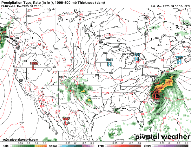
-
I hope we get a "beach day" or two Fri/Sat. We'll have 4 kids under 12 so no one is going to be going in the water much past their knees, if that.
-
There's the pro version and weenie version right there! Lol
-
Assuming it is, they're never exactly the same and small variations can make a big difference with the final results.
-
Yeah, that’ll teach those fukkers to mess with you. Welcome to the new norm. Diseases coming at you in every direction 24/7 365 days a year. Can’t escape it.
-
Even if 22-23 is a good analog winter, that’s only one analog, which has little statistical weight on its own.
-
We'll remeber the weenie back broken calls when it's 65 on 2/19. Will happily declare back broken then.
-
Sections of rural Lee and Dekalb counties had 7"+ totals. Drop that in the metro and that's a huge problem.
-
I'd like to see less than 3/4ths of the mid latitude continent actually below 90F before I'd declare summer's "back broken" - whatever that purely subjective expression really means.. We had a cool week back in July, too - just bear that in mind.
-
And euro has the band it just moved it south about 50 miles
-
HRRR a bit out of range but has big rains in Central NJ
-
Yeah a nice swath from within NJ across Long Island. Maybe even potential for a brief tornado across southern NJ and some waterspouts off the coast.
-
Bit of false fall this week Sent from my SM-S166V using Tapatalk
-

INVEST 99L FORMED: (30/30)
Wannabehippie replied to BarryStantonGBP's topic in Tropical Headquarters
How much will the upwelling from Erin inhibit this invest along with the other disturbance out in the Atlantic. -
NEW DISTURBANCE: Central Tropical Atlantic (10/60)
Wannabehippie replied to BarryStantonGBP's topic in Tropical Headquarters
Looks like there has been upwelling from Erin. How much will this impact this disturbance and the other one out in the Atlantic. -
yeah, things are really dry despite some localized flooding last week. I think we are under half an inch this month here and the Pomperaug river is really low right now, lowest I have see it in quite some time. Trees locally have browning leaves, with the chilly morning it almost looked and felt like late September/early October
-
Looks like a coastal front/strong low level fronto there for the flash flooding. Think last year in SW CT where humid SE winds met up with low level NE flow where the flooding occurred. That's where I think the real FF will be. Seems like one of those deals here where a narrow area here could get 2-3"+ of rain like NAM 3K and HRRR show.
-

Hurricane Erin: 110 MPH - 958 mb - NW @ 7
GaWx replied to BarryStantonGBP's topic in Tropical Headquarters
Regarding restrengthening potential: I just noticed this on the 0Z UKMET: it initialized it at 943 as of 8PM EDT last evening, then weakened it all the way down to 963 as of 12Z/8AM EDT this morning, and then restrengthens her starting today all the way down to 928 mb Thursday at 8PM EDT: HURRICANE ERIN ANALYSED POSITION : 23.9N 71.5W ATCF IDENTIFIER : AL052025 LEAD CENTRAL MAXIMUM WIND VERIFYING TIME TIME POSITION PRESSURE (MB) SPEED (KNOTS) -------------- ---- -------- ------------- ------------- 0000UTC 19.08.2025 0 23.9N 71.5W 943 84 1200UTC 19.08.2025 12 25.2N 72.6W 963 75 0000UTC 20.08.2025 24 26.9N 73.1W 953 79 1200UTC 20.08.2025 36 28.9N 74.3W 942 89 0000UTC 21.08.2025 48 31.6N 74.3W 936 100 1200UTC 21.08.2025 60 34.0N 73.3W 935 96 0000UTC 22.08.2025 72 36.2N 70.8W 928 94 -
I can see what he means though for down into NJ (especially southern NJ). It will be more unstable down that way and better chance for convection. There certainly could be some localized significant flash flooding in those parts tomorrow, especially if any cells train over a specific area. For us though I think flooding potential is very low.


