All Activity
- Past hour
-
In fact, a long-term, comprehensive study published in 2015 followed 2,315 Finnish men over 20 years and found that increased sauna use (4 to 7 times weekly) decreased both all-cause mortality and sudden cardiovascular death by a staggering 40% and 48% respectively compared to 1 time per week use.
-
One of the weirder warnings I’ve seen with a wide gap between the warning and actual line of storms. And it’s warned for 70 mph winds.
-
Yep. Dumping in Riverdale
-
SMH
-
you'd love dry heat, it's great for your skin and heart health and improves life expectancy AI Overview Some research suggests that regular use of dry heat, particularly in the form of sauna bathing, may be associated with an increased lifespan . Studies have indicated that: Sauna use is linked to reduced mortality risk: A long-term Finnish study tracking over 2,300 men over 20 years found that frequent sauna use (4-7 times weekly) correlated with a significantly lower risk of death from all causes and cardiovascular disease, compared to less frequent users. Improved cardiovascular health: Sauna use can enhance cardiovascular function by increasing heart rate, improving circulation, and mimicking some effects of moderate exercise, potentially lowering the risk of cardiovascular events like heart attacks and strokes. Other health benefits: Beyond longevity, sauna use may also contribute to better immune function, detoxification through sweating, cellular repair, reduced stress, and improved sleep.
-
We’re on the compression stroke. It’s coming. Heavy sun here and 85°
-
I spoke to soon earlier. The lowlands are getting rocked.
-
Definitely feel it should be warned. It’s heading straight for me, should be able to say in 15-20 minutes…
-
84/70 here
-
Could be sneaky strong winds in VT into NH and maybe nrn MA 12zish Friday.
-
Wow...
- 1,059 replies
-
- 1
-

-
- severe
- thunderstorms
- (and 2 more)
-
We'll see if this starts to light up later this pm
-
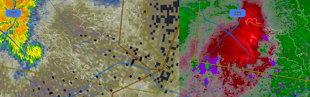
any posters in the area that can provide ground truth?
-
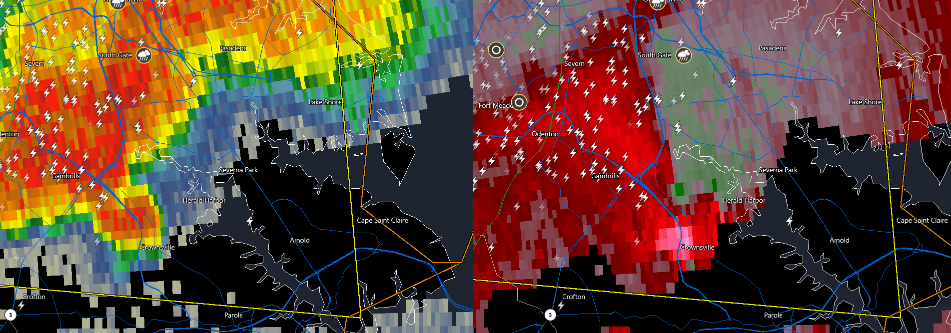
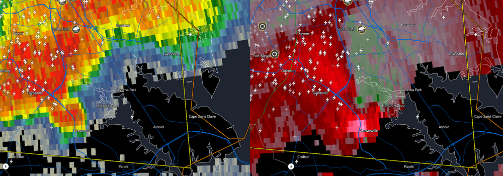
Came here to say this, the appendage is notable even on reflectivity
-
That really should be TOR warned IMO...
-
that rotation has tightened up, you can even see it on BWI terminal radar
- 1,059 replies
-
- 1
-

-
- severe
- thunderstorms
- (and 2 more)
-
brief downpour that lasted 5 min. Long enough to get soaked running from truck to house
-
Looks like mby picked up a quick .20". .44" on the day including brief downpour at 2:30 AM. Rain is heavy, but storms here are too small and moving quickly.
-
GFS still cool for Sunday while the Euro roasts us with offshore flow. Sunday may be hotter than Monday for those of us right on the coast
-
Hopefully that was just some rain, and not a tornado. (I haven't heard of any tornado report by Detroit.)
-
New Day 2 Outlook pretty much unchanged - however, wording suggests the potential for our area to see an upgrade later on and insight into why they arent pulling the trigger yet... ...New England into the Mid-Atlantic/Southeast... Strong heating is expected across a broad, moist warm sector with dewpoints in the upper 60s to low 70s east of the Appalachians by Thursday afternoon. This will result in moderate to potentially strong instability across much of the East Coast. The best chance for more organized storms will be from central Virginia northward where stronger shear will be present beneath 50 knot mid-level flow. A zone of potentially greater severe weather probabilities may be present across the Mid-Atlantic where the greatest instability/shear are expected to overlap. It appears the cold front will lag well behind with the majority of convection developing along a pre-frontal trough during the afternoon. Without the stronger frontal forcing, some concerns about convective coverage/intensity exist, precluding higher probabilities at this time. South of this area, mid-level flow will not be as strong. Therefore, more modest shear will limit greater storm organization. Nonetheless, modest (25 knot) shear will support some multicell storms capable of damaging wind gusts across North Carolina. Even weaker shear will be present across the southeast where strong instability is expected. Storms are not expected to be as organized here, but the strong instability and moist environment could support some water-loaded downdrafts capable of damaging wind gusts.
- 1,059 replies
-
- 1
-

-
- severe
- thunderstorms
- (and 2 more)
-
by the small town of San Jose, Illinois
-
I just had thunder that rattled my windows.
-
Seems like a similar evolution to last June's heatwave
-
83 here and partly sunny.