All Activity
- Past hour
-
probably this summer 'initiation event' ...first of it's kind, if it indeed takes place as currently hinted in that time frame, won't be of the higher DP ilk. It's got the over top appeal. DPs tend to be higher when we get WAR retrogrades with source arriving from the Arklotex region/Gulf. When the ridge blossoms and is well timed with a heat expulsion from the west ( as I outlined above a -d(PNA) switch in the index), it's pulling air up and over the ridge and as arid kinetically charged air from the the Sonora to west TX region. These source/origin differences matter. The over-top variant can then evolve into a DP richer scenario given time ... because as they then go on to relax, the flow veers more SW, switching from the initial WNW delivery. Then the source is more deep south's continental bio farts and also Gulf of Mexico entrained air. This is all meaningless if the current signal changes - just as it sets right now in the guidance, the initial arrival is from that more arid description above. It's kind of like a mid 80s/62 DP ... 90/63. If the expulsion/'Sonoran heat release' is upper tier, than the temperature side of that would naturally be higher.
-
extended ireland mode not really a fan
-
HRRR even changes over here briefly.. if we can get some heavier precip in at the right time it might be fun..
.thumb.png.3092f1ce577c98f428ff6515db5eb188.png)
-
As if this shit doesn't suck enough, you gotta keep reminding us how sick in the head you are. Who enjoys this shit in may.
-
12z HRRR pos Depth maps show I might not have to go far
-
I might have to take a drive to see it one more time
-
who cares if it gets hot and humid in June and July.. Then we can hopefully look forward to beach days and big storms.. Ive been thinking we start heating up the first week of June
-
Horrific. But your trip sounds awesome.
-
we want this kind of violence though
-
The rainy week really is falling apart for sure.
-
Was kayaking on the Colorado River yesterday. 97°. What’s happening back home is an abomination.
-
0.19
-
It’s coming soon and hot , moist and heavy. They are worried
-
One of the banks I did work for sets up a tent every year on the 10th hole, I got to go for free and enjoy food and libations. Only went a couple times but its a good time.
-
My final rain total is 2.74".
-
Looks like a violent afternoon here tomorrow.
-
That would be a great trip around the state.
-
My golf partner played there and always wanted to take me up there, he had a heart attack and won't be golfing for a while if ever,
-
Nieces graduation is outside tomorrow...this is going to be fun
-
Steady moderate rain falling. It looks like east of DC is the winner this morning.
-
4 months too late. Congrats to the 2500ft+ mountain tippy tops in VT/NH.
-
The D7 thru 13 telecon modality is -PNA whilst the polar field indexes are positive. At some point along the way here the perennial correlation blurring associated to summer hemispheric L/W breakdown skewing things will set in... but, it's obviously based upon what is actually happening - not what the climate says it should. In this case, there's identifiable Rosby ordering in the hemisphere - although there is some wave skewing noted... So long as as the indenties are still prevalent however, there's correlative value. A -PNA, combined with a relaxed blocking/+AO(NAO) ... is a telecon convergent signal for warm up over the continental mid latitudes. I also like the robust +PNA in the foreground. In my own researching heat wave genesis for the eastern CONUS, I've noted that they are often preceded by a +PNA effectively generating multi day tropospheric thermal fixing over the W/SW aspects of the continent; then the subsequent mass field shift ejects this heat E into a -PNA signaled ridge ballooning. This sequence of events is like a 10-day in wholesale behavior. A model that actually fits what we are seeing in the telecons at this time. The operational versions have already been hinting. With a +PNA maxing in 5 days, then -d(PNA) taking place, then seeing the seesaw at large scale mass field layout in operationals out there is interesting. Not outright predicting a 'Sonoran heat release'/SW expulsion event, but for an extended tapestry of indicators it's a possibility some amount above base-line climatology.
-
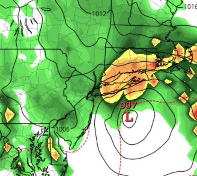
Euro definitely the furthest west with the low
-
Juno Jr. on the Euro:


.png.da29b77a3a584b618268e4e49512f2c4.png)