All Activity
- Past hour
-
Nice shift
.thumb.png.4bac670624d6cd4e77c93b3ce5ddc8f6.png)
-

White Christmas Miracle? December 23-24th
Chrisrotary12 replied to Baroclinic Zone's topic in New England
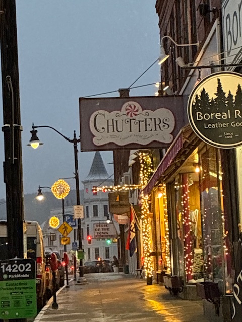
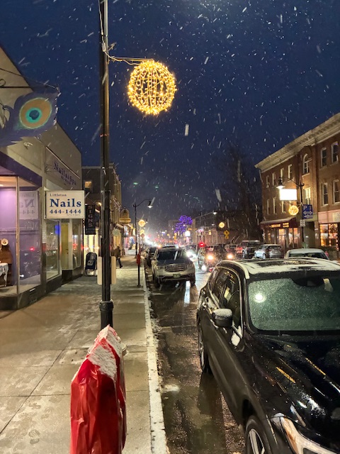
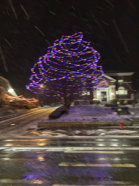
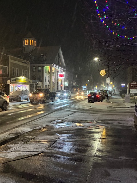
Wintery landscape is back. Makes wife and child happy -
Measured 4” but that includes the little bit that fell yesterday. Went over to Littleton, NH to finish up Christmas shopping. Very festive. Rt. 302 was crap on the way home.
-
ICON moved south a bit but still gets some snow into all of SNE
-

December 2025 Short/Medium Range Forecast Thread
John1122 replied to John1122's topic in Tennessee Valley
Looks like January 1982 is showing up as an analog at 500mb according to Webb. January 1982 was the year it snowed basically every day for a week. The biggest was 3 inches, but it would snow 1/2 to 1 inch almost every day. We had accumulating snowfall on 9 of 10 days. Even Knoxville recorded 1.5 inches 3 days in a row. It was capped off by an epic ice storm on January 18th, that the NWS records for some reason, ignore for Knoxville. It says Knoxville got .21 qpf of ice in the "official" record. This is from a KNS article about January 18th/19th 1982. "That Jan. 18th date was all about ice. The mother of all freezing rains turned the entire area into a skating rink with ice an inch or more thick in most places. Law enforcement reported more than 150 wrecks. Power failures showed up across the grid. Schools and businesses were shut down. Downtown hotels filled up with ice-locked workers unable to get home. The less fortunate spent the night in their cars unable to do anything but spin their wheels. The National Weather Service personnel called it the worst ice storm they'd seen in decades. Stories abounded of people latching up their ice skates for a trip to the store or literally crawling from their cars to get back into their homes and offices." Temperatures in the -10s here just before that ice storm. -
Nam is a very light qpf event for all with snow too far away.
-
I remember that snow event vividly. I had to get to the office and coming out of my subdivision was a slight hill and bend. My tires started slipping as I approached the turn so I hit the brakes and the car just slid while I headed for a mailbox. I took my foot off the brake to get a better position on the brake and the tires got traction and the car turned, barely missing the mailbox. And that event was cold as he!! with temps during snow and that morning in the mid teens. It was so close to being an historic winter for coldcand snow but for the uncooperative mid levels thanks to the u/l lows passing too far to our NW.
-
Closing in on 3”

-

Central PA Winter 25/26 Discussion and Obs
Voyager replied to MAG5035's topic in Upstate New York/Pennsylvania
Unlike those who work in an office or other enclosed building, and have a short commute to work and home, I work outside for a good portion of my day and drive 10-12 hours in whatever winter throws at us. Cold and snow makes what I do for a living exponentially more difficult (and dangerous sometimes) than on warm days. That being said, even though it's imperative that I know how the weather is going to affect my day, perhaps it's time for a break from this forum until spring. My apologies... -

December 2025 Short/Medium Range Forecast Thread
beavis1729 replied to John1122's topic in Tennessee Valley
Yikes, and good stuff…just a bit chilly. It’s strange to me that an algorithm could affect temperature outputs from a model. You’d think the model output is what it is, and then is simply displayed in map form. Maybe there is some interpolation that WxBell and other companies do, to “fill in” the data gaps? A discussion for another time, I suppose. Anyway - as an example of the ongoing cold in eastern AK and the Yukon, Juneau AK dropped to -10 yesterday. It hasn’t been colder than -10 in Juneau since 1974. -
Who else remembers the 1/3/14 (I think that was the date) blizzard? I must say That was probably the coldest snowstorm I have ever experienced here in NYC. Temps in the teens throughout and near blizzard conditions. 7-10” of fluff. Actual blizzard conditions further north and east. 1/29/22 was also very cold. Temperatures in low 20s and upper teens for whole storm. I’m surprised Queens wasn’t included in Long Island’s blizzard warning, I think it actually verified here as well. Last blizzard warning was almost 9 years ago so we are definitely overdue. And that one busted, it was 3/14/17 storm. Instead of the 12-18+”, we ended up sleeting half the day and got 7-10” instead. 1/4/18 actually verified as a blizzard though, even all the way to Newark. That was a great bust in the positive direction. 3-6” expected the evening before the storm. Then winter storm warning for 5-8”, but it ended up being a 9-13” blizzard for NYC. Very cold storm also, and the windiest blizzard I’ve seen aside from 12/26/10
-

White Christmas Miracle? December 23-24th
RUNNAWAYICEBERG replied to Baroclinic Zone's topic in New England
I believe he lives in the armpit of the country now…Florida. -

December 2025 regional war/obs/disco thread
WinterWolf replied to Torch Tiger's topic in New England
Ok, I like that…We enjoy . -
December 2025 regional war/obs/disco thread
RUNNAWAYICEBERG replied to Torch Tiger's topic in New England
Snowy Friday night incoming. Lean back and enjoy it. -
One thing to note is that surface temps are really cold to start. Could be some high ratio snows and better than 10:1
-

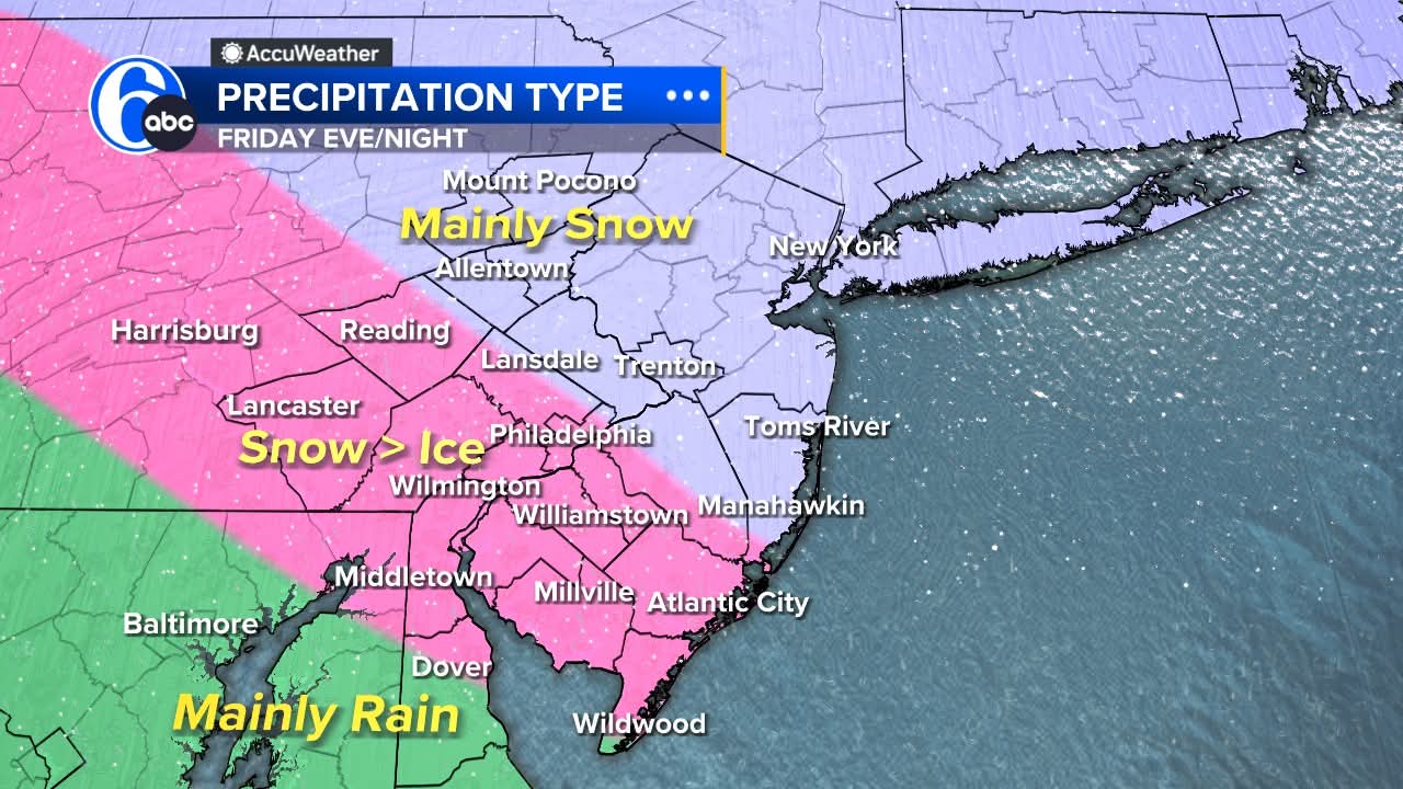
Boxing Night Snow/Sleet/Ice Dec 26-27 Storm Thread/Obs.
Birds~69 replied to Mikeymac5306's topic in Philadelphia Region
Adam Joseph 6abc around 6pm on Facebook a couple hours ago: POST CHRISTMAS STORM First off, thankfully Christmas Eve & Christmas Day will be quiet! Santa will have some strong winds helping him make the rounds, and only a few sprinkles are expected near lunch on Christmas Day. Highs both days in the middle 40s. Now, to Friday!!! A piece of the nasty storm in California will break off and head across the country setting its eyes on the Mid Atlantic for Friday afternoon and night. The issue will be a large area of Artic High pressure in southern Canada. This will send down very cold air from the surface to thousands of feet up. Cold air is dense and heavy so it will be locked in as the storm arrives. The issue then becomes warm air trying to move in in the upper atmosphere as the storm ramps up. Warm air is light and buoyant, so it wants to settle where the precip forms in the storm in this kind of setup. Precip cannot turn to snow after it forms if the air temp is above freezing, so this is crucial in a mixed storm. Depending on the column of air temps from the layer where precip begins, to the ground will supply either rain (above freezing at all levels), freezing rain (shallow cold at only at surface), sleet (deep cold layer under the precip formation zone), and snow (below freezing at all levels). Our area will see all this mess.....the question this far out is where those areas set up. I do not see much rain with this system right now....more snow, sleet, and freezing rain. Some areas will see over 3" of snow! I will be off enjoying two days with my family and will be back to guide you through it all on Friday. Please tune it to Payton and Brittany for the latest. Just wanted to give you a heads up and my current thinking. Right now, this is our thinking and it will be fined tuned the next two days. Please share this in case people are not watching or on social at this time: TIMING: snow for all mid to late afternoon Friday HEAVIEST: falls near dark Friday through Midnight CHANGEOVER: Snow flips to ice in much of the area starting Friday evening. ALL SNOW: looks to be north of the PA Turnpike with less mixing with ice. AVOID TRAVELING: late Friday afternoon into Saturday morning.
-
There will be high ratios with this storm whoever is under the heavy banding.
-
i'd take the 2-5 and run
-
Seems to be a very tenuous situation setting up. This storm is relatively weak and will run into strong high pressure. Due to the storms weakness, it can't penetrate the high pressure and becomes a bit shredded before moving into New England. However, there’s enough cold air in place for at least a few inches of snow. This would be more significant if it was moving slowly but there’s no blocking in North Atlantic so this thing is hauling pretty quickly and isn’t really strong enough for huge rates anyway.
-

White Christmas Miracle? December 23-24th
moneypitmike replied to Baroclinic Zone's topic in New England
Just got in from walking the dog. Somewhere between 2-3" of man snow. No fluff yet. I suspect that'll change once the cooler air works in. In either case, there will be a lot of snow-encased trees in the morning. Hope to wake up to SN+ at 4:30. Enjoy the snow all. -

White Christmas Miracle? December 23-24th
ORH_wxman replied to Baroclinic Zone's topic in New England
Looks like one more round to go through and then we’re prob done.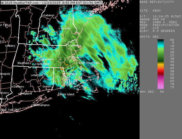
-
December 2025 regional war/obs/disco thread
WinterWolf replied to Torch Tiger's topic in New England
Mid Atlantic deal. -
Would be a bizarre outcome if it verified
-

Central PA Winter 25/26 Discussion and Obs
Mount Joy Snowman replied to MAG5035's topic in Upstate New York/Pennsylvania
Voyager, with all due respect, and I have empathy for what you’re going through, I really do, but this is a weather forum where the vast majority of us are rooting for winter weather in winter. The negative posts can be a bit much at times. I really hope you get to a better place sometime soon. -
Its final Nam has a weird orientation. Looks like a lake effect streamer .

.png.22328624b1bcb98e3eef55c7d239ca86.png)