All Activity
- Past hour
-

2026-2027 Record-breaking El Nino
40/70 Benchmark replied to Stormchaserchuck1's topic in Weather Forecasting and Discussion
Yes, but you keep neglecting the fact that did in fact begin severely east-based. No, the stratospheric conditions were different due to the QBO (west this year and 1982, east in 1997) and the solar cycle (high and descending this year and 1982 as opposed to low and ascending in 1997), which is not impacted by ENSO. No guidance forecasts the warm pool to near the Mexican coast....if you have anything that does, then by all means...present it. Could it make it further east than all guidance currently depicts, sure....not I doubt it's off by that much. -

Strong Nor'Easter/Hybrid Storm Late September 2026
Brian5671 replied to Rjay's topic in New York City Metro
still raining some here but mostly over. About 1.75 storm total. Happy to miss the bigger amts seen elsewhere -

October Comes Early: Late September Multi-Hazard Hybrid Storm
WinterWolf replied to WxWatcher007's topic in New England
What a complete soaker….congrats to those that are pushing 8-10”…that’s impressive. By the time it’s done we should be in the 4” range here. -

E PA/NJ/DE Autumn 2026 Obs/Discussion
The Iceman replied to PhiEaglesfan712's topic in Philadelphia Region
.4” overnight and into this morning. 2.5” on the storm. Still light rain/misting this morning. -

2026-2027 Record-breaking El Nino
Typhoon Tip replied to Stormchaserchuck1's topic in Weather Forecasting and Discussion
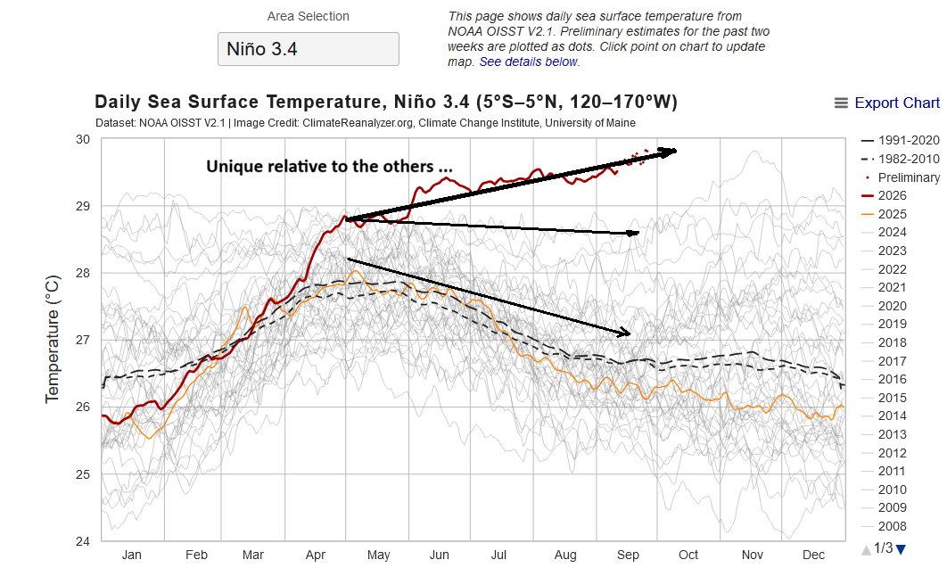
Man ...that 3.4 is astounding really. Just a cursory evaluation and comparison of these curves, https://climatereanalyzer.org/clim/sst_daily/?dm_id=nino3.4 .. what sets this year apart is that every curve there, other than the present year's ongoing ... demoed a period of downward trajectory between mid spring to early autumns. One can make that out just eyeballing, but if you looked at May1 to September15-ish period trend lines, even 2015 was slightly negative during that span of time. Otherwise, they were more demonstratively so. Yet, the 3.4 has risen the entire time... straight through what one can only surmise was/is a climate normal behavior for an intermediate nadir. So, for first time at least among these years since 2008 there was no intermediate negative recovery. I wonder if this would be so for all years - It's a nuance ob but it's true nonetheless. The other obvious elephant in this picture is that this 3.4 is like that jet at a memorial fly by that peals away toward the heavens.. I just find that specific aspect about the trend line since May 1/summer behavior to be interesting for unique behavior.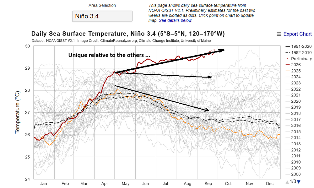
-
Up to 1.37" for the storm and 5.79" for the month. The radar indicates I should pass 6" for September.
-
 1.3.
1.3. -

October Comes Early: Late September Multi-Hazard Hybrid Storm
dendrite replied to WxWatcher007's topic in New England
53° -DZ 0.86” -
 Cialis over the counter: TadaStream - Generic Tadalafil 20mg price
 -

2026-2027 Record-breaking El Nino
bluewave replied to Stormchaserchuck1's topic in Weather Forecasting and Discussion
The east based nature of 1982-1983 backed off during the winter relative to 1997-1998. The stratospheric conditions were related to the different nature of the ENSO forcing between both those seasons. The Central Pacific warm pool has already shifted the farthest to the east it has ever been. This is only expected to increase in the coming months. -
it's raining
-

October Comes Early: Late September Multi-Hazard Hybrid Storm
jlauderdal replied to WxWatcher007's topic in New England
Did your neighbor get his acorns cleaned up before the naw'easter arrived? -

October Comes Early: Late September Multi-Hazard Hybrid Storm
tunafish replied to WxWatcher007's topic in New England
Ouch. Looks like you were just a little too far north and east. 0.83 + 2.45 = 3.28" event total -
2026-2027 Record-breaking El Nino
40/70 Benchmark replied to Stormchaserchuck1's topic in Weather Forecasting and Discussion
There is a reason why 2023 had MC forcing despite having record anomalies in region 4.....warm pool was in the west Pac. This year, record anomalies are over eastern ENSO, but the warm pool is in the western half of ENSO. Look at where the seasonal models place the forcing...no shock. -
 Put your rain pants on and sneak around yards
 -
2026-2027 Record-breaking El Nino
40/70 Benchmark replied to Stormchaserchuck1's topic in Weather Forecasting and Discussion
1982 was very east-based early in the season, as well. The forecast is more east-based in terms of SSTs mid-season, but I don't know how much that will matter given the warm pool in the central Pacific. A large reason why 1997 was better early and 1982 was better later was the stratosphere. -
October Comes Early: Late September Multi-Hazard Hybrid Storm
40/70 Benchmark replied to WxWatcher007's topic in New England
My guess on Friday before this got going was just under 2" in total here, but I should sneak just over that. -
1.43” since it began
-

October Comes Early: Late September Multi-Hazard Hybrid Storm
Lava Rock replied to WxWatcher007's topic in New England
0.58" Pretty infuriating given models had 2-3", but where then revised to 1-2", so likely won't even hit 1". not going to do much. -
Plenty of missing data before 2000 at MPO including no observations at all from the record 93-94 winter in NEPA. The column on the right is total number of missing days for each year. Notice how this recent period since 2000 is the most complete. But since there is no contract snowfall observer at MPO, we have to look to the surrounding areas volunteer snowfall observations. The older observations prior to the airport being build in the early 1960s may have been at a different altitude than the airport due to where the coop observers in the area lived. So some of the warm records could have been from a lower altitude. Time Series Summary for Mount Pocono Area, PA (ThreadEx) Missing Days right column Click column heading to sort ascending, click again to sort descending. 2025 46.4 0 2024 48.2 0 2023 48.3 0 2022 46.4 0 2021 47.5 0 2020 47.8 0 2019 46.2 0 2018 46.4 0 2017 46.8 0 2016 47.4 0 2015 47.2 0 2014 45.1 0 2013 46.6 0 2012 49.3 0 2011 48.3 0 2010 48.0 0 2009 46.3 0 2008 45.7 0 2007 46.5 0 2006 48.1 0 2005 46.5 0 2004 45.9 0 2003 44.8 0 2002 47.2 0 2001 46.2 0 2000 45.0 0 1999 46.9 9 1998 48.5 33 1997 45.0 22 1996 44.9 36 1995 52.1 232 1994 M 365 1993 46.9 128 1992 43.9 39 1991 46.5 46 1990 47.2 96 1989 42.9 67 1988 43.6 31 1987 44.2 27 1986 44.2 9 1985 32.3 242 1984 46.1 0 1983 46.6 1 1982 45.3 0 1981 45.4 0 1980 44.9 0 1979 45.8 0 1978 44.0 0 1977 45.4 1 1976 44.7 0 1975 46.4 0 1974 45.8 0 1973 47.4 0 1972 44.6 0 1971 45.4 0 1970 44.9 0 1969 44.9 0 1968 45.1 0 1967 44.6 0 1966 44.3 0 1965 44.5 0 1964 45.9 0 1963 44.4 0 1962 44.4 0 1961 27.5 331 1960 46.9 137 1959 37.3 216 1958 44.2 4 1957 46.9 7 1956 45.6 3 1955 47.1 7 1954 47.0 4 1953 48.2 20 1952 47.1 0 1951 46.6 0 1950 45.8 1 1949 53.4 182 1948 47.1 92 1947 44.8 0 1946 46.5 0 1945 45.2 0 1944 45.1 0 1943 44.3 0 1942 45.6 0 1941 44.4 0 1940 41.7 0 1939 44.5 0 1938 46.0 0 1937 44.8 0 1936 44.6 0 1935 43.9 0 1934 43.3 18 1933 46.6 78 1932 42.5 0 1931 46.8 0 1930 44.6 56 1929 45.5 0 1928 48.5 61 1927 48.8 84 1926 51.3 204 1925 60.1 243 1924 43.2 151 1923 49.8 212 1922 51.4 181 1921 46.4 122 1920 43.2 0 1919 45.7 0 1918 45.3 0 1917 42.2 0 1916 44.0 0 1915 50.8 90 1914 44.6 122 1913 38.5 143 1912 43.9 0 1911 46.3 5 1910 45.0 3 1909 45.4 9 1908 44.7 11 1907 41.9 5 1906 45.3 1 1905 44.7 0 1904 41.9 1 1903 44.0 12 1902 44.7 4
-

Strong Nor'Easter/Hybrid Storm Late September 2026
lee59 replied to Rjay's topic in New York City Metro
Lost power here early Sunday morning when wind was at its strongest, came back on during the middle of last night. A large tree fell thru the wires and onto a house on my street, everyone is ok. Had 3.21 inches of rain. -
What day is that? And can we quote you for credit when we get there?
-

Strong Nor'Easter/Hybrid Storm Late September 2026
MJO812 replied to Rjay's topic in New York City Metro
Dogfish Shark spotted in Barnegat Bay -

2026 Atlantic Hurricane Season
NorthHillsWx replied to Stormchaserchuck1's topic in Tropical Headquarters
Fay is one of the longest lasting storms that failed to reach hurricane intensity I can remember. We’re into the 30’s on NHC advisories. If that convection persists there’s a chance it retains storm status today too -

2026-2027 Record-breaking El Nino
GaWx replied to Stormchaserchuck1's topic in Weather Forecasting and Discussion
^Thanks. Here is this morning’s NOAA weekly update for relative (for those who don’t know, this much better takes into account GW and thus became the official way of measuring by NOAA a good while ago) Nino anomalies for the average of last week compared to the avg for the prior week: this shows 1+2 still at +3.9 and the other 3 having warmed 0.1. Below that are the comparable weeks in 1997 and 1982: 16SEP2026 3.9 3.0 2.1 0.0 23SEP2026 3.9 3.1 2.2 0.1 24SEP1997 3.8 2.7 1.8 0.5 (the most E based prior to 2026) 22SEP1982 1.5 2.1 2.0 0.6 Compared to past years for the same week, 1+2 region’s +3.9 remains at its highest (weekly records back to 1981) for the 2nd week in a row, beating 1997’s +3.8. Next Monday’s release will likely be the 3rd week in a row at its highest. Nino 3’s +3.1 is its 2nd week in a row of being at a high with it easily beating 1997’s +2.7. Nino 3.4’s +2.2 beats 1982’s +2.0 for the warmest for that week and is its 3rd week in a row at a high. Nino 4’s +0.1 is way cooler than the other regions and also is significantly cooler than many years thus showing how much more E based 2026 is vs any other year on record as of late Sept including the prior most E based 1997: 1994 +0.9 1986 +0.8 2019 +0.7 2002 +0.7 2006 +0.6 2004 +0.6 2023 +0.5 1997 +0.5 https://www.cpc.ncep.noaa.gov/data/indices/rel_wksst9120.txt @bluewave@OSUmetstud@40/70 Benchmark