All Activity
- Past hour
-
 That’s like declaring we’re absolutely not done with snow in mid February. We could get into the 90s in September but each week that passes chances diminsh
 -
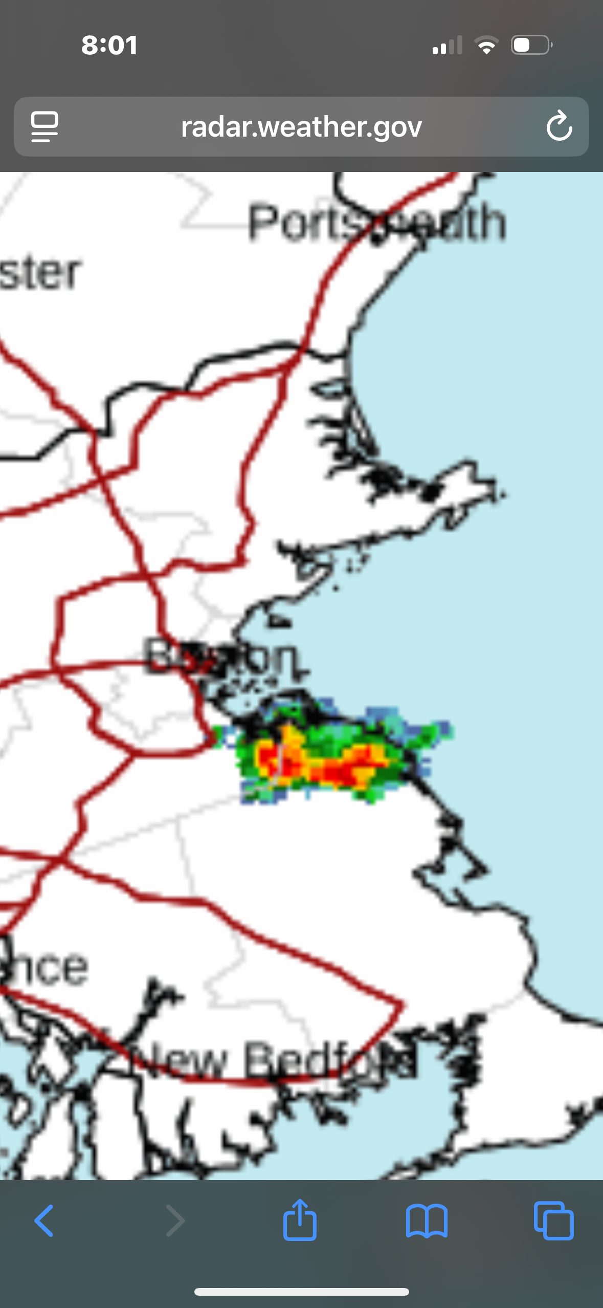
That’s mostly south of me, but outflow boundaries ftw:
-
How does Scoots in S Wey do it. It’ll be the one place that isn’t burning in September/October

-
Close, norwell..just a little southeast of there
-
That cell popped up just to our west, what are the friggin odds lol. Perhaps a quick half inch in the tank?
-
S Wey?
- Yesterday
-
https://www.nasa.gov/blogs/wallops/2025/08/24/nasa-sounding-rocket-mission-targeting-aug-25-launch-attempt/ looks like there could be a rocket launch in the mid atlantic
-
Pouring buckets!
-
hopefully "we" can gin-up a spin-up. And it hooks into NC!
-
it's fall
-
 87 today for my high joining the 86,85, 86 of the past few days of the so called cool down
 -
 We're absolutely not done with 90s. Why are people forgetting it can be hot as hell in September?
 -
Truly spectacular late summer evening
-
Sometimes …. It’s all that’s needed ….. as always……

-
My problem has been lanternflies. I unfortunately found out we have a tree of heaven in our backyard. Those bastards are everywhere.
-
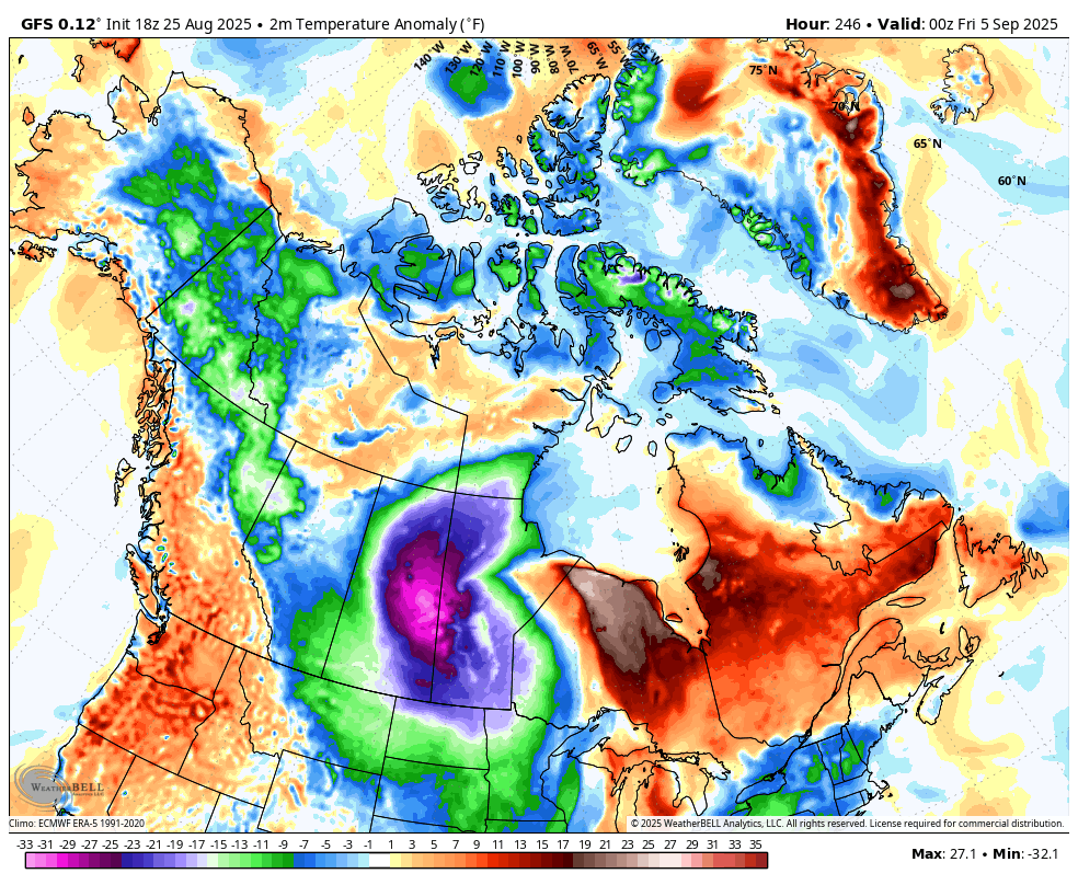
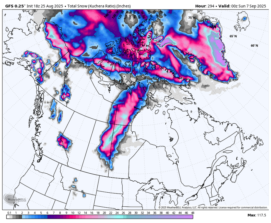
First central Canada blizzard in September (WB 18Z GFS). Let the fun begin!!!!

-
Just a perfect evening for a stroll (I won't complain about this year's particularly persistent crop of mosquitos)
-
Another rip current day at the beach. Longest stretch of ocean swim restrictions in a long time.
-

2025 Spring/Summer Mountain Thread
Met1985 replied to Maggie Valley Steve's topic in Southeastern States
This afternoon has turned straight to Fall. Cloudy with a breeze. Had a high of 71 with a current temp of 62 degrees. -
 marsman changed their profile photo
 -
If we had a year that was typical 100 years ago, people would think they’d moved to Boston or Portland, ME.
-
Hit 93 at 2:30pm.
-
The fact that 1.2 has cooled significantly over the past 2 weeks plus the northern pacific ssta’s raises the possibility of a non ratter.
-
RMNP web cams are all rainy tonight
-
 Cooler air will over spread the region tonight. High temperatures will top out mainly in the upper 70s and lows will fall to lower 60s in New York City through at least Friday. Outside the City, lows in the 50s will be widespread. The cool weather will continue during the weekend. On account of the cool air, August 2025 will be among the five coolest Augusts since 2000. There will be higher-than-climatological risk of at least one period in September with highs in the upper 80s or perhaps 90s. Summers similar to the current one have had September highs of 90 or above about 10 percentage points above that for all other years. The ENSO Region 1+2 anomaly was +-0.1°C and the Region 3.4 anomaly was -0.4°C for the week centered around August 20. For the past six weeks, the ENSO Region 1+2 anomaly has averaged +0.45°C and the ENSO Region 3.4 anomaly has averaged -0.28°C. Neutral ENSO conditions will likely continue into early autumn. The SOI was +21.06 today. The preliminary Arctic Oscillation (AO) was +0.610 today. Based on sensitivity analysis applied to the latest guidance, there is an implied 99% probability that New York City will have a cooler than normal August (1991-2020 normal). August will likely finish with a mean temperature near 73.8° (2.3° below normal). Supplemental Information: The projected mean would be 1.4° below the 1981-2010 normal monthly value.
 -
Something about a frog boiling...