All Activity
- Past hour
-

September 2025 OBS-Discussion centered NYC subforum
SACRUS replied to wdrag's topic in New York City Metro
Records: Highs: EWR: 89 (1986) NYC: 89 (1986) LGA: 88 (1988) JFK: 84 (1986) Lows: EWR: 38 (1942) NYC: 39 (1912) LGA: 43 (1947) JFK: 43 (1991) Historical: 1875: What weather observers “observe” has changed with time. Among the remarks noted by the Lynchburg, VA observer, was today’s migration of hundreds of squirrels across the James River. (Ref. Weather Guide Calendar with Phenomenal Weather Events 2011 Accord Pub. 2010, USA) 1892: Central Park in New York City, NY concluded its wettest month ever with 16.85 inches of rain. (Ref. Wilson Wx. History) 1896 - A hurricane formed on September 22 and lasted until September 30. It formed directly over the Lesser Antilles and hit Cuba, Florida, Georgia, South and North Carolina, Virginia, Washington D.C., and Pennsylvania. Its maximum sustained winds were at 130 mph. The heaviest rainfall deposited in association with the storm was 19.96 inches at Glennville, Georgia. This hurricane was responsible for an estimated 130 deaths and $1.5 million in damage (1896 dollars). 1896: A hurricane moving through the Caribbean Sea and the Gulf of Mexico. The system then tracked inland through the Southeast to the west of Washington, DC. Richmond suffered severely from the cyclone. Communication was gone early on during the storm the only line that remained open belonged to Western Union, the wire than ran to Wilmington, NC. The steeple of the Second Baptist church yielded to the storm, falling across main street. The Governor's Mansion survived the cyclone reasonably well. Damage totaled $150,000 at the state capital. In Petersburg the Imperial Hotel was unroofed. Smaller buildings experienced great damage. Fredericksburg saw its St. George's church steeple injured by the cyclone. In Alexandria the Third Baptist Colored church was razed to the ground ($5000). Over forty windmills were wrecked at Falls Church. Manassas saw its Evangelical Lutheran church blown six inches off its foundation. It was one of the worst storms on record in the District of Columbia as five-minute sustained winds peaked at 66 mph and gusts reached 80 mph; the pressures fell to 29.14" around 11 p.m.. At 10:30 p.m., the steeple to the New York Avenue Presbyterian Church crashed to the ground. A five story brick building was demolished, injuring the adjoining buildings, trapping five men under debris. Many buildings were unroofed. Capitol Hill saw even greater damage. Georgetown experienced its worst storm ever. A few panes of glass at the White House were shattered as well. Winds began to subside by 12:55 a.m.. In all, a $390,000 in damage was incurred. A flash flood at Staunton, along Lewis Creek, overran its banks, killing five. Seven inches of rain on the 30th swelled a large lake near the town, bursting its dam at 10 p.m.. Alarms were sounded as torrents of water rushed down Central Avenue, submerging everything in its path. Twenty-five houses were moved from their foundations before crumbling in the angry waters ($500,000). On the 1st, the and Chesapeake & Ohio Canal merged into one as flood waters increased their height and breadth. (Ref. for 1896 Fall Storm) 1924: Norfolk saw winds reach 76 mph sustained from a cyclone that became nontropical over the Southeast U.S.. In Fauquier county, four inches of rain fell at Leads Manor on the 29th. In Richmond county, 4.60" of rain fell at Warsaw on the 30th. Richmond, VA recorded 2.19 inches of rain on the 29th and 2.85 inches on the 30th for a total of 5.04 inches. Leeds Manor (4.00"), Stuart (4.20"), Urbanna (3.80"), and Winchester (2.05") all set 24-hour rainfall records for September during this tempest. East Coast Rain Storm 1932: Southern California: Tropical cyclone rainfall of 4.38 inches at Tehachapi in 7 hours causes flash floods on Auga Caliente and Tehachapi Creeks resulting in 15 deaths. (Ref. WxDoctor) 1934: DCA had the wettest September on record 17.45 inches at 24th and M street in Washington, DC. (Ref. Washington Weather Records - KDCA) 1943: A tropical storm that formed southwest of Bermuda moved to the northwest and into the Delmarva Peninsula overnight October 1 then dissipated in extreme northeastern Maryland as a depression. Atlantic City, NJ measured a gust to 78 mph and Cape Henry, VA gusted to 72 mph. (Ref. Wilson Wx. History) 1959 - Three tornadoes spawned by the remnants of Hurricane Gracie killed 12 persons at Ivy VA. (The Weather Channel) 1961: An early season snowfall occurred over the Northern Plains with the greatest total of 4 inches falling in the New Ulm- Mankato area in Minnesota. Austin, MN had their earliest measurable snowfall with half an inch. Omaha, NE had its first September snow in 70 years. (Ref. AccWeather Weather History) 1970: A nineteen-month drought in southern California came to a climax. The drought, that made brush and buildings tinder dry, set up the worst fire conditions in California history as hot Santa Anna winds sent the temperature soaring to 105 degrees at Los Angeles, and to 97 degrees at San Diego. During that last week of September whole communities of interior San Diego County were consumed by fire. Half a million acres were burned, and the fires caused fifty million dollars damage. (David Ludlum) 1970 - A nineteen month drought in southern California came to a climax. The drought, which made brush and buildings tinder dry, set up the worst fire conditions in California history as hot Santa Anna winds sent the temperature soaring to 105 degrees at Los Angeles, and to 97 degrees at San Diego. During that last week of September whole communities of interior San Diego County were consumed by fire. Half a million acres were burned, and the fires caused fifty million dollars damage. (David Ludlum) 1977 - The temperature at Wichita Falls, TX, soared to 108 degrees to establish a record for September. (The Weather Channel) 1979: This was the eighth day of 29 consecutive days when no measurable rain fell at Chicago, IL. The only measurable rain for the month came on the 1st with 0.01 inches. This was their driest September on record. Rockford, IL only received 0.05 inches of rain; their driest month ever. (Ref. Wilson Wx. History) 1985: An early season snowstorm covered much of the Arrowhead Region of Minnesota with 7 to 9 inches of snow. Some snow depths reported for the event, which ended the next day, were 7 inches at Babbitt and Aurora, 7.5 inches at Isabella, and 8.5 inches at Poplar Lake. (Ref. AccWeather Weather History) 1986 - Thunderstorms, which had inundated northern sections of Oklahoma with heavy rain, temporarily shifted southward producing 4 to 8 inches rains from Shawnee to Stilwell. Baseball size hail and 80 mph winds ripped through parts of southeast Oklahoma City, and thunderstorm winds caused more than half a million dollars damage at Shawnee. (Storm Data) 1987 - Afternoon thunderstorms in Michigan produced hail an inch in diameter at Pinckney, and wind gusts to 68 mph at Wyandotte. A thunderstorm in northern Indiana produced wet snow at South Bend. Seven cities in the northwestern U.S. reported record high temperatures for the date, including readings of 98 degrees at Medford OR and 101 degrees at downtown Sacramento CA. (The National Weather Summary) (Storm Data) 1988 - Unseasonably warm weather prevailed over Florida, and in the western U.S. The afternoon high of 94 degrees at Fort Myers FL was their tenth record high for the month. Highs of 98 degrees at Medford OR and 99 degrees at Fresno CA were records for the date, and the temperature at Borrego Springs CA soared to 108 degrees. (The National Weather Summary) 1989 - Thirteen cities reported record high temperatures for the date, as readings soared into the upper 80s and 90s from the Northern and Central High Plains Region to Minnesota. Bismarck ND reported a record high of 95 degrees, and the temperature reached 97 degrees at Broadus MT. Afternoon thunderstorms developing along a cold front produced wind gusts to 60 mph at Wendover UT. (The National Weather Summary) (Storm Data) 1992: The past month was the coldest September ever recorded in interior Alaska. Fairbanks averaged a frigid 31.7° which was 13.2° below normal and the first below freezing September ever. Beginning on the 9th and on every day for the rest of the month, a new record low was set for either low minimums or low maximums, or both. On this date, the city plunged to 3° to set a new all-time record low for September. Snowfall for the month totaled 24.4 inches which was more than three times the previous record for September. 2001: Phoenix, AZ had an average temperature for the month of 92.2°, the city's hottest September day on record. (Ref. Wilson Wx. History) 2003: Grand Rapids, Michigan: With a trace of snow hitting the ground, Grand Rapids records its earliest occurrence of measurable snowfall, beating the old mark by a week. (Ref. WxDoctor) 2004: Driven mostly by outbreaks from Hurricanes Frances and Ivan, 279 tornadoes were recorded for the month, by far the most tornadoes ever to occur in September in the U.S. West Palm Beach, FL had its wettest month on record with 29.40 inches of rain. Hurricanes Frances and Jeanne contributed most to the total. (Ref. Wilson Wx. History) 2006: A rare F1 tornado struck North Berwick, ME, causing damage to roofs, windows. Damaged totaled $125,000. (Ref. Wilson Wx. History) The first phase of the deluge focused on the Southeast, starting on September 26 (4.20 inches Macon, Georgia). September 27th Wilmington, North Carolina had 10.33 inches of rain. As the remains of Nicole tracked toward North Carolina on September 30, tropical downpours spread into the Northeast, On September 30, Baltimore, Maryland, reported its second wettest day on record, with 6.02 inches of rain. Two-day totals on October 1 reached 7.58 inches in Wilmington, Delaware, and exceeded five inches northward into western Massachusetts. Event totals exceeded 16 inches in eastern North Carolina, and over a foot of rain fell northward into the Chesapeake Bay region. Although widespread flooding occurred, drought conditions preceding the deluge mitigated the impacts. Today Portsmouth, Virginia storm spotter ID vpor002 measured 9.10 inches an all-time station daily rainfall record. [database to 1976] (Ref. Weatherwise U.S. Weather Highlights of 2010 page 9) -

Category Five Hurricane Humberto
NorthHillsWx replied to WxWatcher007's topic in Tropical Headquarters
Imelda is winning the fight -

2025-2026 ENSO
40/70 Benchmark replied to 40/70 Benchmark's topic in Weather Forecasting and Discussion
2020-2021 was actually a pretty positive EPO, too...just wasn't that warm. -
2025-2026 ENSO
40/70 Benchmark replied to 40/70 Benchmark's topic in Weather Forecasting and Discussion
No, I wasn't implying that.....the implication was as stated....we are due for more aggressive regresson in other areas. I think wall-to-wall anything is difficult to pull off....2011-2012 did it, but February was close. -
September 2025 OBS-Discussion centered NYC subforum
SACRUS replied to wdrag's topic in New York City Metro
64 / 60 cloudy. Clouds all the way linked down to the Imelda / front - no rain. Clouds lingering may break the 80s streak for those that continued it yesterday. Cool ENE/NE flow for 48 hours Wed and Thu before flow comes around wirh ridge into the northeast. Warm to much warmer Fri - Tue next week with more low- mid 80s in the warmest spots. Overall above normal beyond there. -

Category Five Hurricane Humberto
hawkeye_wx replied to WxWatcher007's topic in Tropical Headquarters
Wow, Humberto has had an epic collapse. In just a couple days it has gone from cat 5 to an exposed vort. -
 DCA: +1.5 NYC: +1.6 BOS: +1.6 ORD: +2.8 ATL: +1.5 IAH: +1.1 DEN: +1.2 PHX: +1.1 SEA: +0.5
 -
I guess I posted about 15 minutes too early
-

Spooky Season (October Disco Thread)
mreaves replied to Prismshine Productions's topic in New England
I don't care about the blue hallucinations but would love to have the rain. -
Yeah, as long as we have sun and low humidity, that would be great. If we are stuck in the swamp pattern, however, no thanks
-
And this general idea of a big ACE comeback has been forecasted for several weeks by the Euro Weeklies. The EW after an upcoming break once Humberto and Imelda dissipate continue to forecast ACE to pick up again as we get to mid and even moreso as we approach late month.
-
BULLETIN Hurricane Imelda Intermediate Advisory Number 15A NWS National Hurricane Center Miami FL AL092025 800 AM EDT Tue Sep 30 2025 ...IMELDA BECOMES A HURRICANE... SUMMARY OF 800 AM EDT...1200 UTC...INFORMATION ---------------------------------------------- LOCATION...29.0N 76.9W ABOUT 180 MI...290 KM N OF GREAT ABACO ISLAND ABOUT 755 MI...1215 KM WSW OF BERMUDA MAXIMUM SUSTAINED WINDS...75 MPH...120 KM/H PRESENT MOVEMENT...NE OR 35 DEGREES AT 7 MPH...11 KM/H MINIMUM CENTRAL PRESSURE...980 MB...28.94 INCHES @WxWatcher007
-
I never said I think we are going to have a +EPO winter, I simply pointed out that we haven’t had a wall to wall +EPO winter since 11-12. Not sure why you think I was implying that for this winter, which I certainly am not
-
You are not wrong.
-
(002).thumb.png.6e3d9d46bca5fe41aab7a74871dd8af8.png)
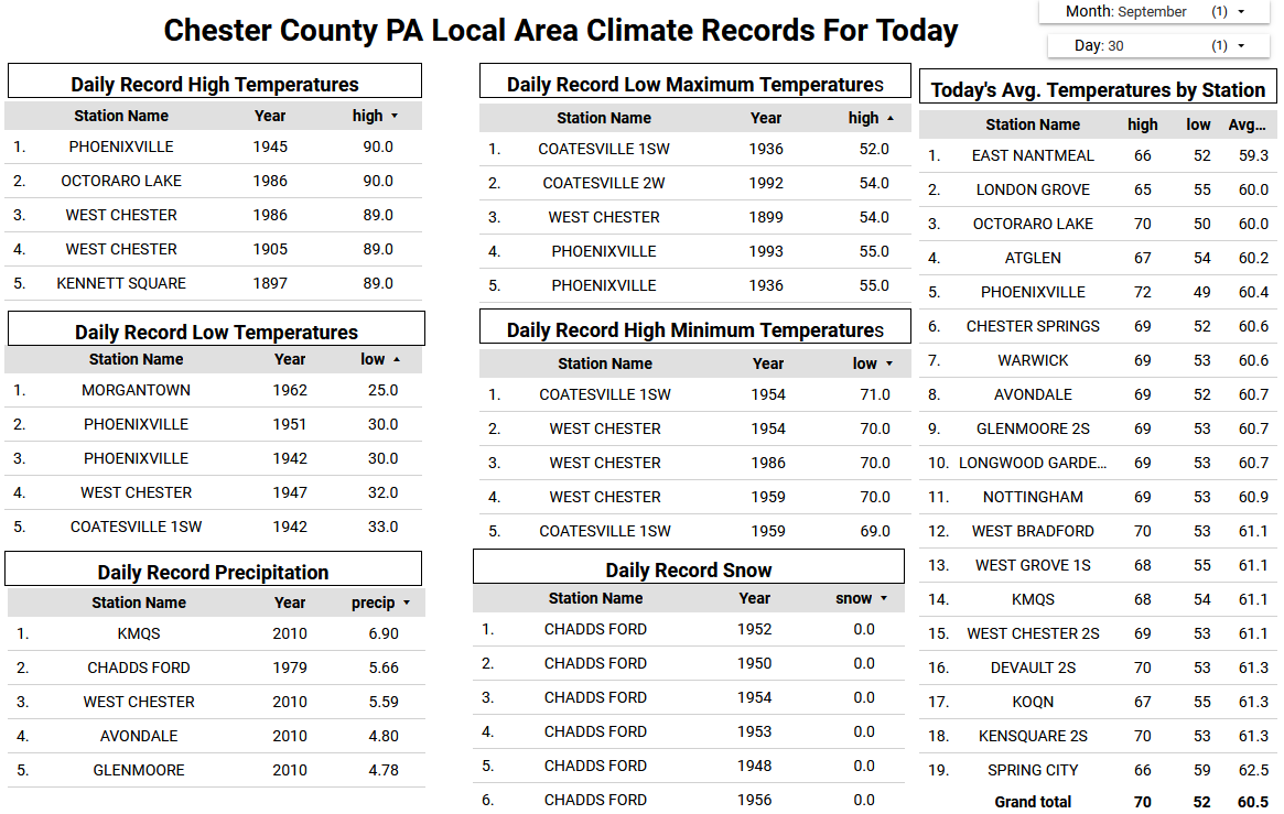
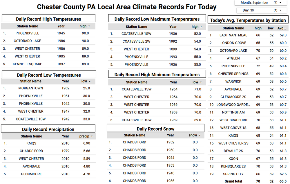
Central PA Fall Discussions and Obs
ChescoWx replied to ChescoWx's topic in Upstate New York/Pennsylvania
Today we should see temperature once again reach above normal levels in the mid to upper 70's. There will however be a noticeable lowering of humidity and dew points by this afternoon. We cool to below normal levels as we start October tomorrow with high temperatures across most of the county remaining in the mid to upper 60's for the rest of the work week. By the weekend we should see a warming trend with temperatures rising into the mid to upper 70's. There is almost no chance of rain for at least the next week.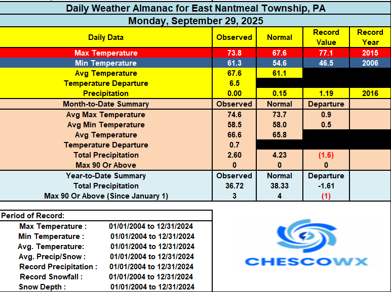
-

September 2025 OBS-Discussion centered NYC subforum
Dark Star replied to wdrag's topic in New York City Metro
Yes, but I welcomed it. I actually saw some local ponds freeze in Union County, NJ. -
E PA/NJ/DE Autumn 2025 Obs/Discussion
ChescoWx replied to PhiEaglesfan712's topic in Philadelphia Region
Today we should see temperature once again reach above normal levels in the mid to upper 70's. There will however be a noticeable lowering of humidity and dew points by this afternoon. We cool to below normal levels as we start October tomorrow with high temperatures across most of the county remaining in the mid to upper 60's for the rest of the work week. By the weekend we should see a warming trend with temperatures rising into the mid to upper 70's. There is almost no chance of rain for at least the next week.
-
I can't decide what we're better at. Above normal temperatures or cloudy damp weather. We excel at both. Looks like yet another gloomy day.
- Today
-

Central PA Fall Discussions and Obs
Jonesy56 replied to ChescoWx's topic in Upstate New York/Pennsylvania
KMDT hit 93 on Oct 2, 2019, Cap City reached 95... I was not a happy camper. -

Central PA Fall Discussions and Obs
mahantango#1 replied to ChescoWx's topic in Upstate New York/Pennsylvania
Enjoying this late summer warmth...sometime soon those cold gusty 30-40 mph northerly winds will takeover. Making it unpleasant to be outside. Not looking forward to those unrelenting winds. Until then, I'll take what this current warm weather has to offer. -
You got it man
-
Social media has degraded forecasting just as it has society in general.
-
With the storm now moving in a more favorable direction considering the shear vector we are starting to see signs of strengthening this morning. Convection is firing over the center and starting to wrap into the dry slot the storm ingested last night. Despite the dry air, pressure falls have continued and we are now seeing convection become more organized as well. This system is well on its way to hurricane intensity
-
2025 Atlantic Hurricane Season
NorthHillsWx replied to BarryStantonGBP's topic in Tropical Headquarters
2025 ACE is now within about 10 of average. With the two ongoing storms, albeit with Humberto likely to become non tropical today, we will be within single digits of average. I cannot stress enough how impressive this is given how far behind we were just a couple weeks ago -
I couldn't agree more. He has the same exact words that he uses. He hypes things up so much that I just shake my head. It's nuts how much he believes what he's saying, and what's worse, he has a lot of followers and subscribers I totally believe what's coming out of his mouth. Pure bull crap.