All Activity
- Past hour
-
The angle of the moderate rain around DC I want to see in a month when it’s 25.
-
 The old penalty structure was probably too harsh and would tend to inhibit people from posting relatively not-so-late forecasts, but having absolutely no late penalties is not that good either long-term, I will give it some thought for 2026 if we keep going, and have late penalties that make sense. Other contests that I am involved with have much more routine late penalties that are applied automatically (whether by me or some other person running a contest). The turnout for those is larger, which tends to mean that the contest organizer(s) are not as wary of annoying people with late penalties. I think as a scientific question, there is usually no more skill shown on 2nd or 3rd than there is on 1st or day before that. The late penalty concept for a monthly forecast contest is mostly to encourage on-time entries so everyone feels equally likely to do well and also so the organizer can get the table of forecasts done and move on to their normal routines. Sooner or later somebody is going to crush that 810 barrier, this could be the month, never know.
 -

2025-2026 Fall/Winter Mountain Thread
Daniel Boone replied to Buckethead's topic in Southeastern States
Hopefully the Canadian will be right. 3k looks rather paltry. -

November 2025 general discussions and probable topic derailings ...
powderfreak replied to Typhoon Tip's topic in New England
Any terrain has gotten plastered over the past week. Anything above 1500ft is very white. The river valleys are not white. It’s that time of year.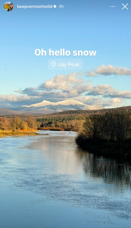
-
Glad you guys are okay!
- Today
-
Same! Greatest game I’ve ever been to. I might still be recovering
-
November 2025 general discussions and probable topic derailings ...
powderfreak replied to Typhoon Tip's topic in New England
46/43. Solidly in the warm-sector after one of the coldest mornings. Life comes at you fast, all the sudden dew points in the 40s are noteworthy. It’s been awhile. -

November 2025 general discussions and probable topic derailings ...
rimetree replied to Typhoon Tip's topic in New England
Someone had a premonition when they wrote the title of this thread...yikes. Coldest morning of the season today...got to 27.6. Looking forward to some wintery vibes but don't expect anything notable until 12/15 or later. The early model fantasies never seem to pan out. -
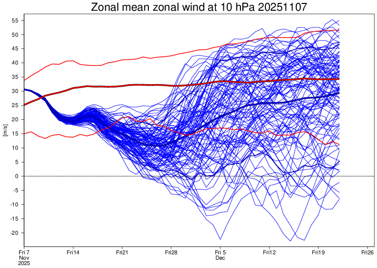
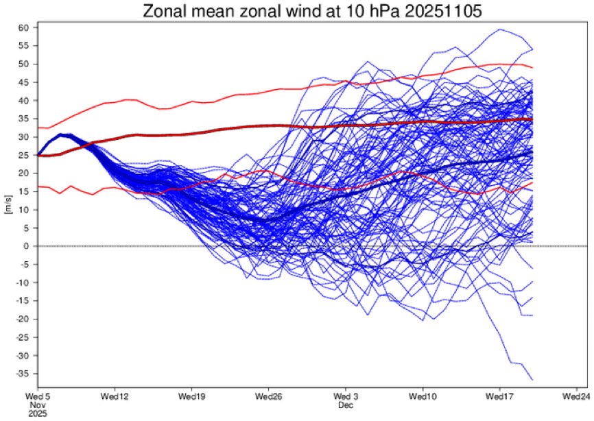
Similar to yesterday meaning Wednesday’s run (mean dipped to only +7) remains the weakest: Wed. run:
-

2025-2026 ENSO
Stormchaserchuck1 replied to 40/70 Benchmark's topic in Weather Forecasting and Discussion
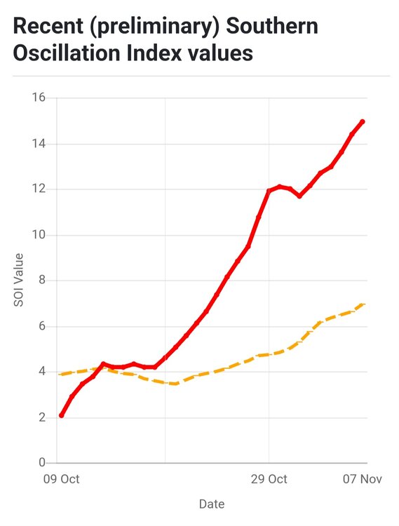
30-day is the highest since December 2022! It had actually gone 31 straight months without passing +10, now it's up to +15. Between that, the Oct-Nov N. Hemisphere 500mb pattern, and now a -3c pocket developing in the ENSO subsurface.. you can make a case for a La Nina presence this Winter. I'm curious to see how it goes with the fact that 21 of the last 29 months have been +PNA (CPC), and what happens there going forward. -
What did the EPS SPV forecast look like today?
-
I don’t think this is true. Now if they had a cold bias, that would be true.
-
I of course don’t post every day’s runs. But because I posted yesterday’s significantly colder week 4, I felt obligated to post today’s significantly warmer week 4 so as to not appear one-sided. Chuck’s guess that that was a top 15 percentile jump is as reasonable an educated guess as any. So, it was a “pretty big jump” as he said though nothing at all extreme, especially considering that’s still out at week 4. Consider how much colder it got for early next week on all models since that was during only week 2! So, considering all of this and the inherent unpredictability out a month, sig. jumps that far out on any long range ensemble are pretty common and shouldn’t ever be surprising.
-

November 2025 general discussions and probable topic derailings ...
Spanks45 replied to Typhoon Tip's topic in New England
Nice little rainstorm out there.... -
SOI....climbing
-

2025-2026 Fall/Winter Mountain Thread
Buckethead replied to Buckethead's topic in Southeastern States
Currently 45 with a very loud thunderstorm and rain/graupel in Wolf. The 0z high res Canadian and 3km nam are looking good along the border for Sunday night and Monday. Sent from my SM-S908U using Tapatalk -
NMME page is pure ugly if you like winter. https://www.cpc.ncep.noaa.gov/products/NMME/monanom.shtml
-
GSP . If the closed low sags far enough south that it cross the area on Monday, don`t be surprised to see a few snow flurries break containment east of the mountains, with flurries possible across the foothills and Piedmont Monday evening. The chance is low, but definitely nonzero.
-
These long range peeks make me very glad our recent renovations included new French doors and others plus the gas logs. Our formerly super drafty home is much better but still two doors to go. The new smart thermostat and room sensors too, woo boy bring on the cold. My old self would love some 76/77 77/78 style winters for my kids to see lol. .
-

E PA/NJ/DE Autumn 2025 Obs/Discussion
Albedoman replied to PhiEaglesfan712's topic in Philadelphia Region
sorry, I could pee more than this rain. I am more exited about seeing the possibility of white rain in the next few days. I will sleep just fine tonight. At least the wind has stopped. Tired of seeing down ash trees. -
Strong vort coming over Sun/Mon,be interesting if some flurries can break out over the piedmont.
-
The negative PNA makes it like winning a 65 mustang but with an electric engine
-
The 12z GFS folded almost completely for how shallow it originally showed the trough. Might be good to keep in mind for later this winter.
-
Is it necessary to reference a place of suffering like Sheppard Pratt, even in jest? That does not seem appropriate. Will this be deleted? No apologies in advance.
-
Strong storms moving through. Buncombe NC-Haywood NC-Yancey NC-Madison NC- 1014 PM EST Fri Nov 7 2025 ...STRONG THUNDERSTORMS WILL IMPACT MADISON...NORTH CENTRAL HAYWOOD...NORTHERN BUNCOMBE AND SOUTHERN YANCEY COUNTIES THROUGH 1045 PM EST... At 1014 PM EST, Doppler radar was tracking strong thunderstorms along a line extending from 9 miles northwest of Marshall to 16 miles southeast of Newport. Movement was east at 50 mph. HAZARD...Wind gusts up to 40 mph.


