All Activity
- Past hour
-
GFS hits Bermuda
-
The cleaner air is probably a piece of the puzzle as to why the actual temperatures in the Northern Pacific have greatly exceeded the climate model forecasts in recent years.
-

September 2025 OBS-Discussion centered NYC subforum
bluewave replied to wdrag's topic in New York City Metro
The drier conditions have been probably helping out with this record heat for so late in the season. RECORD EVENT REPORT NATIONAL WEATHER SERVICE NEW YORK, NY 442 PM EDT SUN SEP 28 2025 ...RECORD DAILY HIGH TEMPERATURE SET AT NEWARK NJ... THE HIGH TEMPERATURE REACHED 89 DEGREES TODAY AT NEWARK LIBERTY INTERNATIONAL AIRPORT. THIS BREAKS THE OLD RECORD OF 87 DEGREES, SET IN 2014. RECORDS FOR THE NEWARK NJ AREA GO BACK TO 1931. ALL CLIMATE DATA ARE CONSIDERED PRELIMINARY UNTIL REVIEWED BY THE NATIONAL CENTERS FOR ENVIRONMENTAL INFORMATION (NCEI). EVENT REPORT NATIONAL WEATHER SERVICE NEW YORK, NY 530 PM EDT SUN SEP 28 2025 ...RECORD DAILY HIGH TEMPERATURE SET AT LAGUARDIA NY... THE HIGH TEMPERATURE REACHED 85 DEGREES TODAY AT LAGUARDIA AIRPORT. THIS BREAKS THE OLD RECORD OF 84 DEGREES, LAST SET IN 2014 AS WELL AS 1954. RECORDS FOR THE LAGUARDIA NY AREA GO BACK TO 1939. ALL CLIMATE DATA ARE CONSIDERED PRELIMINARY UNTIL REVIEWED BY THE NATIONAL CENTERS FOR ENVIRONMENTAL INFORMATION (NCEI). RECORD EVENT REPORT NATIONAL WEATHER SERVICE NEW YORK, NY 418 PM EDT SUN SEP 28 2025 ...RECORD DAILY HIGH TEMPERATURE SET AT ISLIP NY... THE HIGH TEMPERATURE REACHED 84 DEGREES TODAY, SEPTEMBER 28TH AT ISLIP MACARTHUR AIRPORT. THIS BREAKS THE OLD RECORD OF 80 DEGREES, SET IN 2015. RECORDS FOR THE ISLIP NY AREA GO BACK TO 1963. ALL CLIMATE DATA ARE CONSIDERED PRELIMINARY UNTIL REVIEWED BY THE NATIONAL CENTERS FOR ENVIRONMENTAL INFORMATION (NCEI). RECORD EVENT REPORT NATIONAL WEATHER SERVICE MOUNT HOLLY NJ 0155 AM EDT MON SEP 29 2025 ...RECORD HIGH TEMPERATURE SET AT ALLENTOWN PA... A RECORD HIGH TEMPERATURE OF 86 DEGREES WAS SET AT ALLENTOWN PA YESTERDAY. THIS BREAKS THE OLD RECORD OF 85 DEGREES SET IN 1941. RECORD EVENT REPORT NATIONAL WEATHER SERVICE MOUNT HOLLY NJ 0155 AM EDT MON SEP 29 2025 ...RECORD HIGH TEMPERATURE SET AT READING PA... A RECORD HIGH TEMPERATURE OF 87 DEGREES WAS SET AT READING PA YESTERDAY. THIS BREAKS THE OLD RECORD OF 86 DEGREES SET IN 1941 AND 1943. RECORD EVENT REPORT NATIONAL WEATHER SERVICE ALBANY NY 0440 PM EDT SUN SEP 28 2025 ...RECORD HIGH TEMPERATURE SET AT GLENS FALLS NY... A RECORD HIGH TEMPERATURE OF 85 DEGREES WAS SET AT GLENS FALLS NY TODAY. THIS BREAKS THE OLD RECORD OF 82 DEGREES SET IN 1959. -
@Stormchaserchuck1 Here comes your warm/dry -PDO October
-
We disagree on poleward ridging. -QBO/-ENSO supports a destabilized tropical tropopause, on equator forcing/convection and a flat Aleutian ridge. Not saying no poleward ridging at all but as much as we saw last winter? Nope IMO
- Today
-

September 2025 OBS-Discussion centered NYC subforum
LibertyBell replied to wdrag's topic in New York City Metro
and 82 here, that 79 at JFK is also an outlier lol -
September 2025 OBS-Discussion centered NYC subforum
LibertyBell replied to wdrag's topic in New York City Metro
Too much traffic and congestion up there. -
September 2025 OBS-Discussion centered NYC subforum
LibertyBell replied to wdrag's topic in New York City Metro
Don't think the climate has been stable for thousands of years, the 1700s and 1800s were extremely wild with temperature swings. I'm not even sure how we would deal with a repeat of 1917-18, that must have been truly horrendous. -

Spooky Season (October Disco Thread)
Snowedin replied to Prismshine Productions's topic in New England
That Christmas was something else. I remember looking for the switch for the a/c that morning and then realizing we’d turned it off nearly 2 months prior! That day was the definition of torch. -
That has never happened. Two tropical cyclones never merge together.
-
The 0z Canadian gets Imelda close enough to Humberto that they end up merging and becoming one storm. If that happens, assuming the storm is still tropical, how do they decide which name the storm retains?
-
But everything is out to sea.
-

2025 Atlantic Hurricane Season
WxWatcher007 replied to BarryStantonGBP's topic in Tropical Headquarters
The GFS and Euro look like they’ve been trying to catch up with showing more vorticity and maybe a weak low developing, but time and shear may be inhibitors. There’s very clearly spin, but no convection whatsoever. It’s at least lemon worthy imo. -
The 0Z UKMET (a model that tends to be a bit more stingy with TCG than the GFS) is the 2nd run in a row that develops a TC from the current C Gulf weak surface low after it moves S into the Bay of Campeche. This run actually has minimal TS winds early on. Whereas the prior run then moved it into a threatening position in the W-C Gulf, this run only moves it slowly back N to the end of the run: NEW TROPICAL CYCLONE FORECAST TO DEVELOP AFTER 108 HOURS FORECAST POSITION AT T+108 : 19.9N 94.7W LEAD CENTRAL MAXIMUM WIND VERIFYING TIME TIME POSITION PRESSURE (MB) SPEED (KNOTS) -------------- ---- -------- ------------- ------------- 1200UTC 03.10.2025 108 19.9N 94.7W 1009 36 0000UTC 04.10.2025 120 19.7N 93.9W 1008 31 1200UTC 04.10.2025 132 19.5N 93.9W 1006 31 0000UTC 05.10.2025 144 20.1N 94.2W 1005 29 1200UTC 05.10.2025 156 20.2N 94.0W 1005 26 0000UTC 06.10.2025 168 20.7N 94.5W 1004 27
-
Poor Jalen Hurts signing autographs... he has to keep writing "Hurts" "Hurts" "Hurts"
-
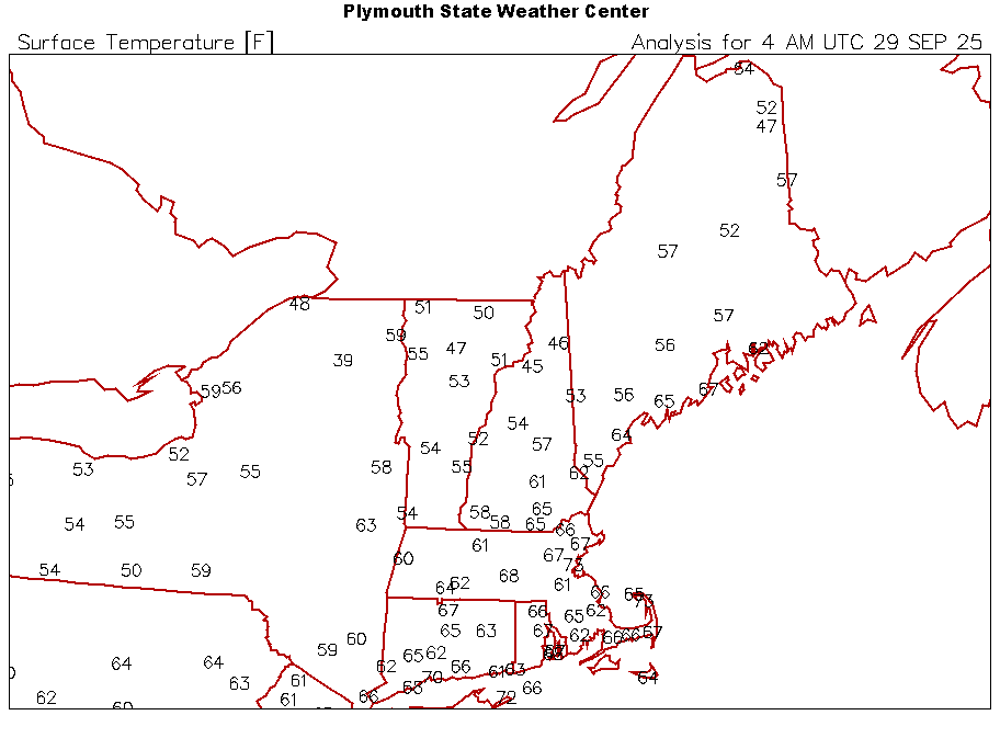
Quite the gradient depending on local topography across the same latitude from west to east. SLK 39F PBG 59F BTV 55F MVL 47F BML 46F
-
Kind of surprising that a QB under .500 after 4 games has never won a Super Bowl.. They have all been 2-2 or better No No, a 0-4 NFL team has never won a Super Bowl.
-
Somehow based on my pegged lows Aug will have had a lower monthly low then September will, it got down to 5.3C on Aug 30th and I haven't had anything lower than 5.9C on the 9th!! Forecast for 6C low this Weds which is Oct 1. This is an incredibly unlikely occurrence. After the terrible wx last week we've turned a leaf and its sunny again, no clouds today here. Yet again WUN/TWN shows 10 days of no precip, I wish!! Even better, mainly to out sun those 10 days lol.
-
-
 DCA +4.3 NYC +3.8 BOS +3.5 ORD: +5.4 ATL: +4.0 IAH: +3.6 DEN: +1.0 PHX: +1.3 SEA: -0.5
 -

2025-2026 ENSO
40/70 Benchmark replied to 40/70 Benchmark's topic in Weather Forecasting and Discussion
Okay, care to acknowledge the other five factors I mentioned? -
Intensity guidance keeps ticking up. Watch this be our 4th straight major hurricane on the season
-
Recon has been in Imelda and although it has not intensified much (there are stronger FL winds showing up now), it is confirming that the satellite appearance of more organization near the center is legit. Note that curved band of deep convection near the center, and how it is trying to wrap upshear. We'll see if the shear currently present keeps this organizational trend in check. Product: Air Force Vortex Message (URNT12 KNHC)Transmitted: 29th day of the month at 2:20ZAgency: United States Air ForceAircraft: Lockheed WC-130J Hercules with reg. number AF98-5307Storm Name: ImeldaStorm Number & Year: 09 in 2025 (flight in the North Atlantic basin)Mission Number: 20Observation Number: 09 ( See all messages of this type for this mission. )A. Time of Center Fix: 29th day of the month at 1:53:20ZB. Center Fix Coordinates: 24.74N 77.09WB. Center Fix Location: 27 statute miles (44 km) to the SE (142°) from Nassau, Bahamas.C. Minimum Height at Standard Level: 1,420m (4,659ft) at 850mbD. Minimum Sea Level Pressure: 998mb (29.47 inHg)E. Dropsonde Surface Wind at Center: From 160° at 3kts (From the SSE at 3mph)F. Eye Character: Open in the southeastG. Eye Shape & Diameter: Circular with a diameter of 25 nautical miles (29 statute miles)H. Estimated (by SFMR or visually) Maximum Surface Wind Inbound: 31kts (35.7mph)I. Location & Time of the Estimated Maximum Surface Wind Inbound: 80 nautical miles (92 statute miles) to the NE (46°) of center fix at 1:28:30ZJ. Maximum Flight Level Wind Inbound: From 104° at 46kts (From the ESE at 52.9mph)K. Location & Time of the Maximum Flight Level Wind Inbound: 75 nautical miles (86 statute miles) to the NE (45°) of center fix at 1:30:00ZL. Estimated (by SFMR or visually) Maximum Surface Wind Outbound: 28kts (32.2mph)M. Location & Time of the Estimated Maximum Surface Wind Outbound: 16 nautical miles (18 statute miles) to the SW (228°) of center fix at 1:58:30ZN. Maximum Flight Level Wind Outbound: From 344° at 38kts (From the NNW at 43.7mph)O. Location & Time of the Maximum Flight Level Wind Outbound: 35 nautical miles (40 statute miles) to the SW (228°) of center fix at 2:04:00ZP. Maximum Flight Level Temp & Pressure Altitude Outside Eye: 16°C (61°F) at a pressure alt. of 1,526m (5,007ft)Q. Maximum Flight Level Temp & Pressure Altitude Inside Eye: 20°C (68°F) at a pressure alt. of 1,525m (5,003ft)R. Dewpoint Temp (collected at same location as temp inside eye): 19°C (66°F)R. Sea Surface Temp (collected at same location as temp inside eye): Not AvailableS. Fix Determined By: Penetration, Radar, Wind, Pressure and TemperatureS. Fix Levels (surface & flight level centers within 5nm of each other): Surface and 850mbT. Navigational Fix Accuracy: 0.02 nautical milesT. Meteorological Accuracy: 4 nautical milesRemarks Section - Remarks That Were Decoded... Maximum Flight Level Wind: 46kts (~ 52.9mph) which was observed 75 nautical miles (86 statute miles) to the NE (45°) from the flight level center at 1:30:00Z Remarks Section - Additional Remarks... RAGGED EYEWALL 50% COVERAGE
-
The last 9 days of minimum temperatures: 39, 32, 30, 38, 60, 56, 60, 62, 58. Quite the whip-lash from crisp and frosty nights, to windows open all night. Don't need heat or AC though.
-
I disagree. The situation is different from before...they fired Billick back in 2007 when things got too bad. To me, things have never gotten THIS bad under Harbaugh--the failures are usually in the playoffs not this early in the season. This feels like it's leading to a "breaking point" moment; I have never seen players so defeated and looking like they've given up on the coaching before. I think this is different.


