All Activity
- Past hour
-

Central PA Winter 25/26 Discussion and Obs
mahantango#1 replied to MAG5035's topic in Upstate New York/Pennsylvania
Yes those rainfall totals dwindled. What looked like a good rain event went to crap. Just like our snow storms they went to crap too so far this winter. Hopefully Blizz can pull that magic rabbit out of his hat 30 here also. -
Depending on your location, the cold is short lived as in around 5 days or so. Even the extended forecast for Muncy Valley PA. Shows the temps climbing upper 20s and mid 30s around the 22nd.
-
We lost everything EPS snowfall is back to 0
-
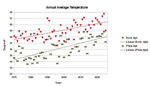
Here's a comparison for the east coast, Philadelphia and Richmond, roughly the same distance and direction as Detroit/Dayton. Using the regression line, the Philly Airport is as warm today as the Richmond Airport was in 1970. I like using the regression line because that is the best estimate of the current temperature.
-
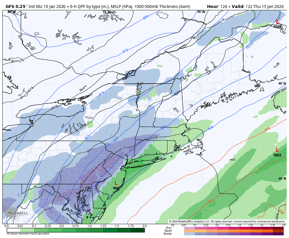
The trough is wide and positive tilting. Early during the week I miss spoke of gfs run but is showed this system going from NC to out to sea. Unless the trough changes I don't see this coming up the coast. Then again we have this weekend system we're there's 1 - 2 inches of rain for delmarva. Never any cold are when we have precipitation.
-

Central PA Winter 25/26 Discussion and Obs
pawatch replied to MAG5035's topic in Upstate New York/Pennsylvania
Rainfall total has sure dwindled down. Originally .76” then it went to .51” 30 degrees -
Same ole $hit over and over. Somebody should write a good book about this. So depressing.
-
Northern stream dominates, no STJ interaction to speak of, and cold doesn’t make it south or east at all for either timeframe. Euro and gfs summed up.
-

Central PA Winter 25/26 Discussion and Obs
Blizzard of 93 replied to MAG5035's topic in Upstate New York/Pennsylvania
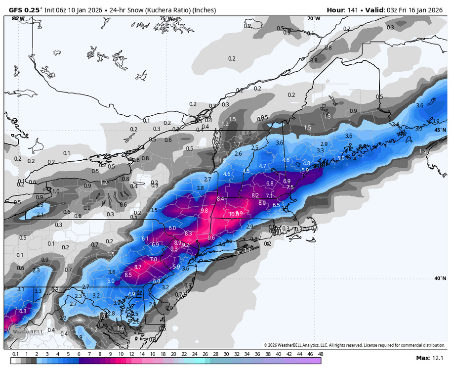
The 6z GFS for the 15th still has a moderate event for the LSV, but is nothing like its 0z run. Many of us in the LSV would still sign for this 6z version.
-
Wow epic disaster on ops last night. Ensembles aren’t as bad but ops are ugly, keep your children away
-
Central PA Winter 25/26 Discussion and Obs
Blizzard of 93 replied to MAG5035's topic in Upstate New York/Pennsylvania
Unfortunately there was no other model support for the 0z GFS. Still something to track, but the GfS was all alone at 0z. -
Euro is basically no storm or precip for anyone after today
-
Central PA Winter 25/26 Discussion and Obs
mahantango#1 replied to MAG5035's topic in Upstate New York/Pennsylvania
- Today
-

January 2026 regional war/obs/disco thread
moneypitmike replied to Baroclinic Zone's topic in New England
AMOUT Nice to be in the WWA at Pit2. Even the progged 1-2 will make for a helpful mask on whatever damage has occurred over the past couple days. -

E PA/NJ/DE Winter 2025-26 Obs/Discussion
Ralph Wiggum replied to LVblizzard's topic in Philadelphia Region
After seeing the 3 major ens systems, pretty safe to say the gfs op was on acid that run. -
There is practically zero support across any of the 3 major ensembles for the Jan 15 system. Those members that do have a slp south of say 40n swing it way off the coast and harmlessly ots. Pretty safe to say the gfs is an outlier here, but I also think realistically most already knew this, tho we always hold hope for the best.
-

E PA/NJ/DE Winter 2025-26 Obs/Discussion
Albedoman replied to LVblizzard's topic in Philadelphia Region
I posted this on the 12/27 Winter is going to take a brief break after this BS first of the year storm of only 1-3 inches if we are really lucky. I see no snowstorms until after the 15th and it will warm up into the upper 40's to 50's . I do think we will pay the piper for this brief warm up by Marin Luther Kings day-- seems to be the pattern the last 5 years. All I can say is the drought situation in our area is only going to worsen as the Gulf storm production is shut down for business. Believe me, dried up wells and sinkhole formation with dropping groundwater tables with waterline breaks galore will be the talk of the town in the next three weeks as the ground starts to thaw out with what little moisture is in it. The base flows of the creeks will begin to drop again too. We really need a 96 type of storm event asap. Still holding-------- -
Nothing to show at all on the 0Z Euro - no snowfall and little precip after this weekend throughout the entire run
-

January 2026 Medium/Long Range Discussion
Stormchaserchuck1 replied to snowfan's topic in Mid Atlantic
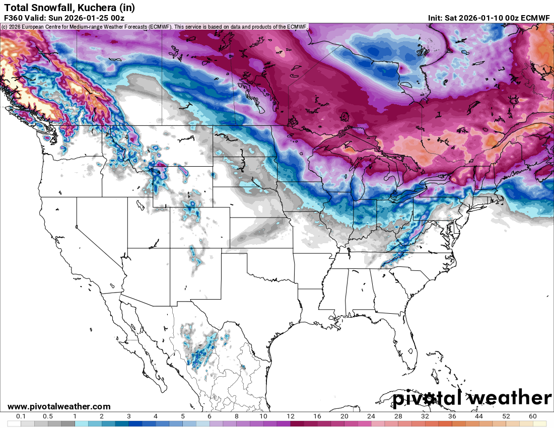
Well at least we are going into a cold pattern again. PNA is changing to positive (it still hasn't been positive a single day this Winter - since Dec 1) Which is supported by the ENSO subsurface - I have found when warm water makes it east of the dateline, +PNA is more likely to occur. Kelvin waves impact the N. Pacific pattern, my theory. I think we'll have some good shots at snowstorm when the new pattern sets in, this early stuff is the thread the needle, trough is still progressive and it's unlikely that we'll get 18 hours of rain, then a blizzard on the backend with how dry the pattern has been. I think later on - last week of January and maybe going into Feb we will have some high probability snowstorm chances -
Just like last year, and probably more so, southern Canada continues to get crushed. Thanks La Niña.

-
Time is running out? Lol we got 6 to 7 days before the 1st one and 200+ hours before no 2.. we got plenty of time
-
Euro ai isn’t as bad. Thermals are iffy but idk much about how these ai models are doing with those details. Decent snow in the mountains for the 2nd one. Let’s see how the EPS looks compared to the OP.
-
Welp…certainly wouldn’t be surprising as that’s been par for the course for years now but man that would stink given how high the potential is with the overall setup.
-
70 and sunny incoming. You all thought it was gonna snow here? LOL.
-
Well another awful night of modeling and time is running out