All Activity
- Past hour
-

Central PA Winter 25/26 Discussion and Obs
Blizzard of 93 replied to MAG5035's topic in Upstate New York/Pennsylvania
NAM twins are looking good for tomorrow am.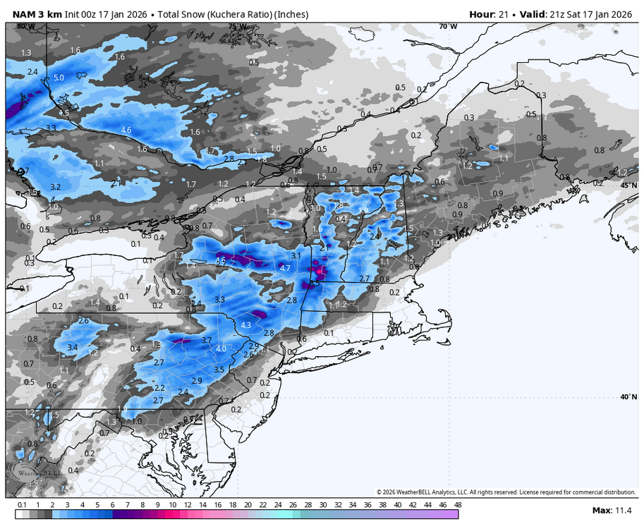
-

First Legit Storm Potential of the Season Upon Us
Sey-Mour Snow replied to 40/70 Benchmark's topic in New England
RRFS looks like it’s coming NW.. -

First Legit Storm Potential of the Season Upon Us
Baroclinic Zone replied to 40/70 Benchmark's topic in New England
Made a comment about this yesterday I believe. If that kicker trajectory is steeper, it should allow our storm to amplify some more. -

First Legit Storm Potential of the Season Upon Us
ORH_wxman replied to 40/70 Benchmark's topic in New England
That’s a pretty solid advisory event for eastern third….maybe even flirting with low end warning type stuff in far SE MA -
NAM is that south park meme “I ain’t heard no bell”
-

E PA/NJ/DE Winter 2025-26 Obs/Discussion
LVblizzard replied to LVblizzard's topic in Philadelphia Region
That Sunday coastal storm keeps disappearing and then coming back. Almost as if it’s teasing all us weenies. -

First Legit Storm Potential of the Season Upon Us
40/70 Benchmark replied to 40/70 Benchmark's topic in New England
Just unreal...can see where this is going. One event just NW of me, and the other just south. This are sucks rotten horse balls. -

Storm potential January 17th-18th
RU848789 replied to WeatherGeek2025's topic in New York City Metro
Just wait 6 hours, lol - and for the inclusion of the flight data...big move NW for the NAM - this is all round 2 through the end... -
First Legit Storm Potential of the Season Upon Us
Baroclinic Zone replied to 40/70 Benchmark's topic in New England
That was a huge shift by NAM. Wetter than GFS and Euro. -
Simply cyclical climate swings again nothing to see here....
-

First Legit Storm Potential of the Season Upon Us
dendrite replied to 40/70 Benchmark's topic in New England
I think there’s too much spacing to really have much effect. -

Let’s talk winter!! Ohio and surrounding states!! 24'-25'
TheClimateChanger replied to buckeye's topic in Lakes/Ohio Valley
It's been a great winter for Central Ohio. Since 2014, only 2018 saw more to date at Columbus! -
First Legit Storm Potential of the Season Upon Us
Sey-Mour Snow replied to 40/70 Benchmark's topic in New England
Hrrr Nam rgem are closer to AIs than gfs and euro -
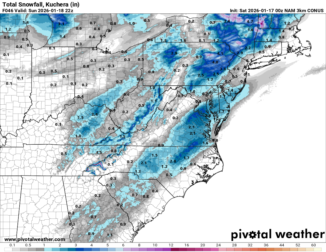
Nice moderate event on tap for the interior tomorrow. 0z NAM is a nice 3-4” for 84 corridor in OC
-
First Legit Storm Potential of the Season Upon Us
dendrite replied to 40/70 Benchmark's topic in New England
Yeah that late little amplification of the vortmax gives E MA a little boost before it slides east. -

First Legit Storm Potential of the Season Upon Us
RDRY replied to 40/70 Benchmark's topic in New England
So the Great Lakes low drops in more behind the coastal. That the reason for the west shift?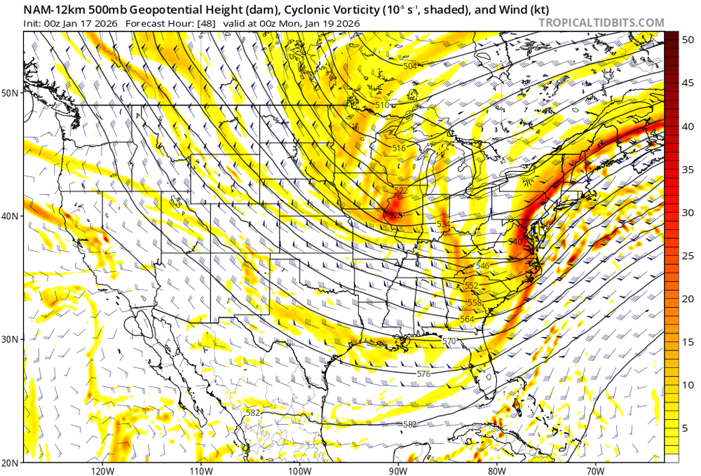
-
Compared with the 18:
-

Pittsburgh/Western PA WINTER ‘25/‘26
colonel717 replied to Burghblizz's topic in Upstate New York/Pennsylvania
Snow has started here. Looks like some decent returns to my south. -

Storm potential January 17th-18th
Franklin0529 replied to WeatherGeek2025's topic in New York City Metro
I need to see more then AI. -

First Legit Storm Potential of the Season Upon Us
DomNH replied to 40/70 Benchmark's topic in New England
NAM still likes that inverted dong over E MA early Monday AM. -
Still snowing in Long Island and SNE
.thumb.png.33b77e46f16c9ce9fa57a255650d0537.png)
-
Because as the chart clearly shows they are of course not warming at the same rate....PHL is exceeding as you would expect the warming at what we would expect at a non-UHI site.
-

First Legit Storm Potential of the Season Upon Us
MJO812 replied to 40/70 Benchmark's topic in New England
Still snowing in Long Island and SNE.thumb.png.5787d1308385fcce969beaa3f4dd01d3.png)
-
This has a the makings of a big surprise for Tidewater VA

-

Storm potential January 17th-18th
WeatherGeek2025 replied to WeatherGeek2025's topic in New York City Metro
i think euro caves tonight and shows at least a few inches for sunday for the city


(002).thumb.png.6e3d9d46bca5fe41aab7a74871dd8af8.png)


.png.ef7ddebd9c5fe54ae141b9c219dac179.png)
.png.e3958b02807d33b7ffcdbbb004f0b7f9.png)