All Activity
- Past hour
-
Op Euro not impressed with winter weather chances the first week of the month.
-
Just got a text alert from EPAWA for Sussex county NJ. Snow arrives between 5-8pm Friday. Heavy at times Friday night. Ends as light snow Saturday morning. 4-8" accumulation. I'm assuming the 4" amounts would be for SW Sussex, I guess he's figuring there might be some sleet there. I'm in NE Sussex county, so maybe 6-8" here.
-

Central PA Winter 25/26 Discussion and Obs
pasnownut replied to MAG5035's topic in Upstate New York/Pennsylvania
could also be byproduct of being SE of them there mtns and not having the forcing mechanism as it is only a 1005-8 mb slp, so qpf might not be crazy without good forcing down here in the perverbial jip zone. I'm still rooting on the weaker option so that whatever falls has less WAA to worry about. -
-

December 2025 Short/Medium Range Forecast Thread
Matthew70 replied to John1122's topic in Tennessee Valley
I wish. The Canadian sadly is never right. -

-
Yeah, I said the same thing, I'll read about it on slack in a few mintues to see there thinking.
-

Boxing Night Snow/Sleet/Ice Dec 26-27 Storm Thread/Obs.
penndotguy replied to Mikeymac5306's topic in Philadelphia Region
WSW just hoisted -
merry Christmas to you! This is a million times better than usual. Things can’t be perfect
-
High of 72 so far..
-
Mt holly too for 5 to 8
-
According to @snowfanthis is nothing.
-
We all know you’re one of us. Have a seat.
-
let's hear your thoughts instead of complaining about people on a weather board being excited for some snow
-
Surprised they left E Suffolk out but these days they rarely put areas in they are not highly confident reach 6 or will have both snow/mixed precip
-

26th-27th event, coming at us like a wounded duck.
Sey-Mour Snow replied to Go Kart Mozart's topic in New England
Watch up for the NYC metro and all of Fairfield County -
WSW for 5-8” for Morris County
-
not a single sounding posted in this thread. lots of kuchera maps though
-
Central PA Winter 25/26 Discussion and Obs
pasnownut replied to MAG5035's topic in Upstate New York/Pennsylvania
While it is a tad concerning, based on SLP being a tick S of 6z when the goods are in the hood, i'd not worry too much. qpf distribution is driven more by SLP placement and going to weeble wooble a bit. IF the future runs do the norther shift, then you n I need to worry more. -
Nothing for me lol
-
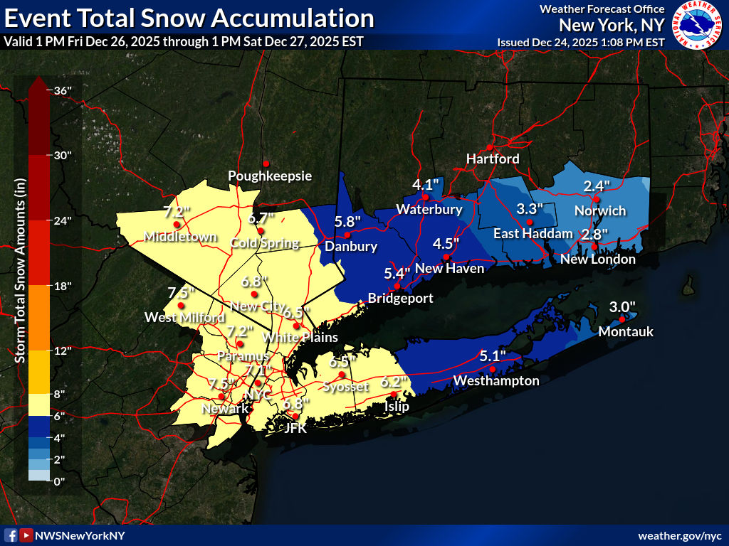
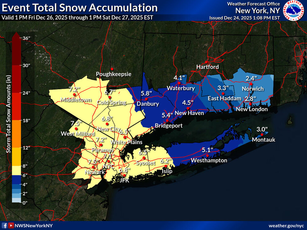
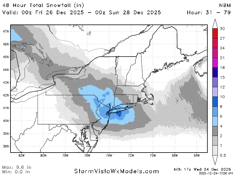
RGENT - WINTER WEATHER MESSAGE National Weather Service New York NY 107 PM EST Wed Dec 24 2025 CTZ005-009-NJZ002-004-006-103>108-NYZ067>075-078-080-176>179-250215- /O.NEW.KOKX.WS.A.0004.251226T2100Z-251227T1800Z/ Northern Fairfield-Southern Fairfield-Western Passaic-Eastern Passaic-Hudson-Western Bergen-Eastern Bergen-Western Essex- Eastern Essex-Western Union-Eastern Union-Orange-Putnam-Rockland- Northern Westchester-Southern Westchester-New York (Manhattan)- Bronx-Richmond (Staten Island)-Kings (Brooklyn)-Northwest Suffolk- Southwest Suffolk-Northern Queens-Northern Nassau-Southern Queens- Southern Nassau- 107 PM EST Wed Dec 24 2025 ...WINTER STORM WATCH IN EFFECT FROM FRIDAY AFTERNOON THROUGH SATURDAY AFTERNOON... * WHAT...Heavy snow possible. Total snow accumulations between 4 and 8 inches possible. * WHERE...Portions of southern Connecticut, northeast New Jersey, and southeast New York. * WHEN...From Friday afternoon through Saturday afternoon. * IMPACTS...Plan on slippery road conditions. The hazardous conditions may impact the Friday evening commute. PRECAUTIONARY/PREPAREDNESS ACTIONS... Monitor the latest forecasts for updates on this situation. && $$ For more information from the National Weather Service visit https://weather.gov/nyc
-
Yes please
-
Winter storm watch 4-8” URGENT - WINTER WEATHER MESSAGE National Weather Service New York NY 107 PM EST Wed Dec 24 2025 Northern Fairfield-Southern Fairfield-Western Passaic-Eastern Passaic-Hudson-Western Bergen-Eastern Bergen-Western Essex- Eastern Essex-Western Union-Eastern Union-Orange-Putnam-Rockland- Northern Westchester-Southern Westchester-New York (Manhattan)- Bronx-Richmond (Staten Island)-Kings (Brooklyn)-Northwest Suffolk- Southwest Suffolk-Northern Queens-Northern Nassau-Southern Queens- Southern Nassau- 107 PM EST Wed Dec 24 2025 ...WINTER STORM WATCH IN EFFECT FROM FRIDAY AFTERNOON THROUGH SATURDAY AFTERNOON... * WHAT...Heavy snow possible. Total snow accumulations between 4 and 8 inches possible. * WHERE...Portions of southern Connecticut, northeast New Jersey, and southeast New York. * WHEN...From Friday afternoon through Saturday afternoon. * IMPACTS...Plan on slippery road conditions. The hazardous conditions may impact the Friday evening commute. PRECAUTIONARY/PREPAREDNESS ACTIONS... Monitor the latest forecasts for updates on this situation. &&
-
The weenie givers have been quiet
-
I started in late August when it was in the upper $30's with physical silver. Been buying ever since. I never got into the metals because of the transaction costs (dealer reduced prices, ebat, etc), but I have no intent on selling. It's going to children/grandchildren, so I don'tcare abouttransaction costs. But I do believe we go higher from what I see with all the sovereign hoarding, especially China. And then it's been added as a critical metal. Too much more to mention here.