All Activity
- Past hour
-
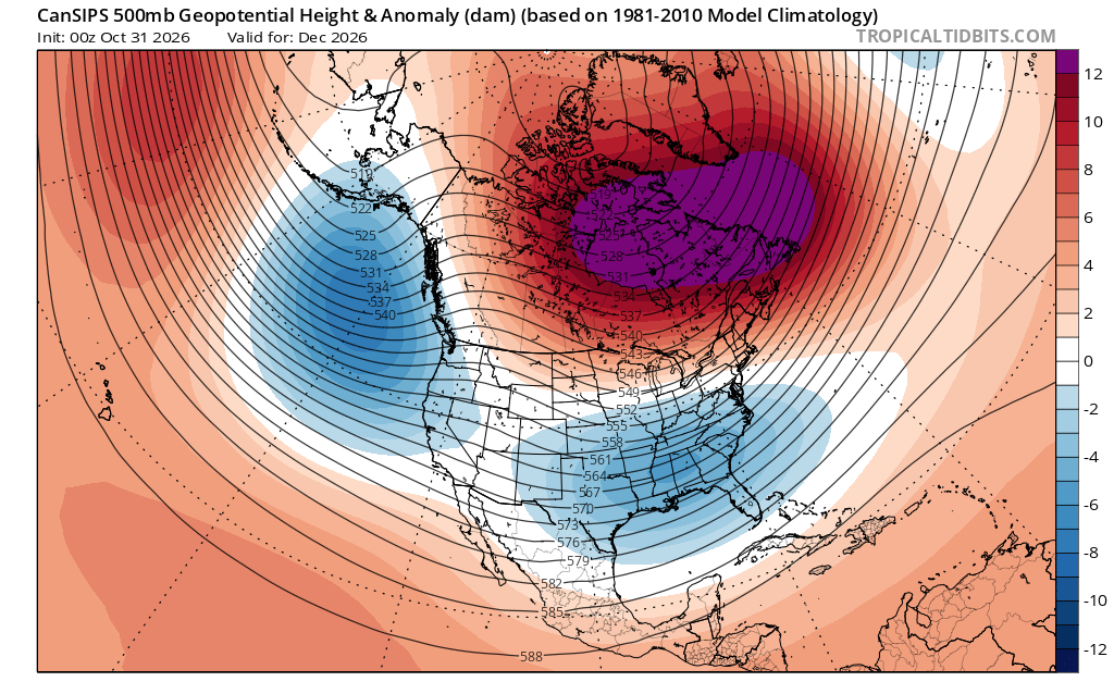
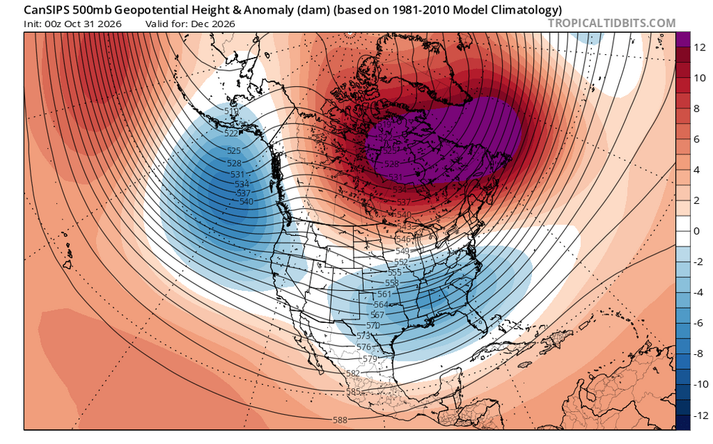
Looking ahead to early winter - plenty of blocking up north but need the ridge to expand further west into western Canada to allow colder air in - will have an active storm track across country - storm tracks uncertain
-
older nam had 80 inch for some storms..
-

2026-2027 Record-breaking El Nino
GaWx replied to Stormchaserchuck1's topic in Weather Forecasting and Discussion
Thanks, Adam. Impressive! What is the second warmest in history for 3.4 absolute ~Nov 1st and what year? -

2026-2027 Record-breaking El Nino
bluewave replied to Stormchaserchuck1's topic in Weather Forecasting and Discussion
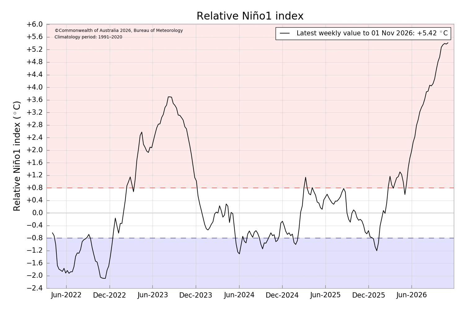
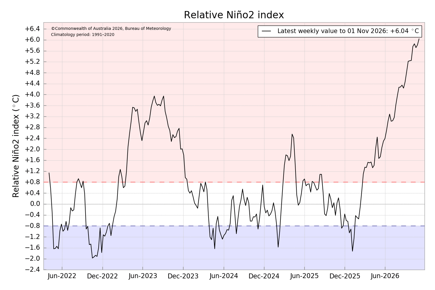
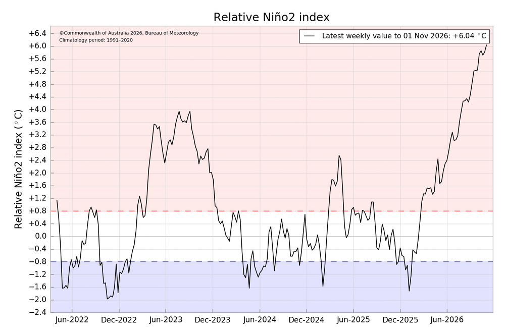
The extreme east based warm pool and forcing are better reflected by the actual ONI values. Nino 1+2 continues to set records along with the other regions. Now up to +5.4 on the week. The BOM RONI is at +6.04 in its Nino 2 region. https://www.cpc.ncep.noaa.gov/data/indices/ 28OCT2026 26.7 5.4 29.5 4.4 30.2 3.4 30.1 1.4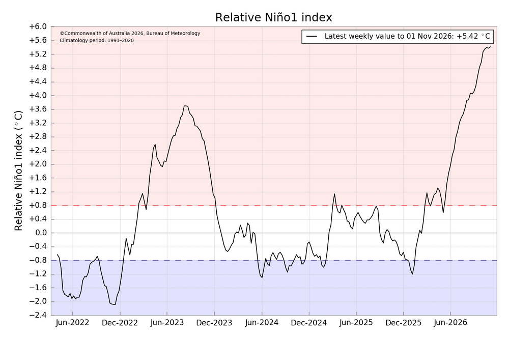
-
BWI: 19.0" DCA: 12.0" IAD: 21.0" RIC: 9.0" SBY: 3.5"
-
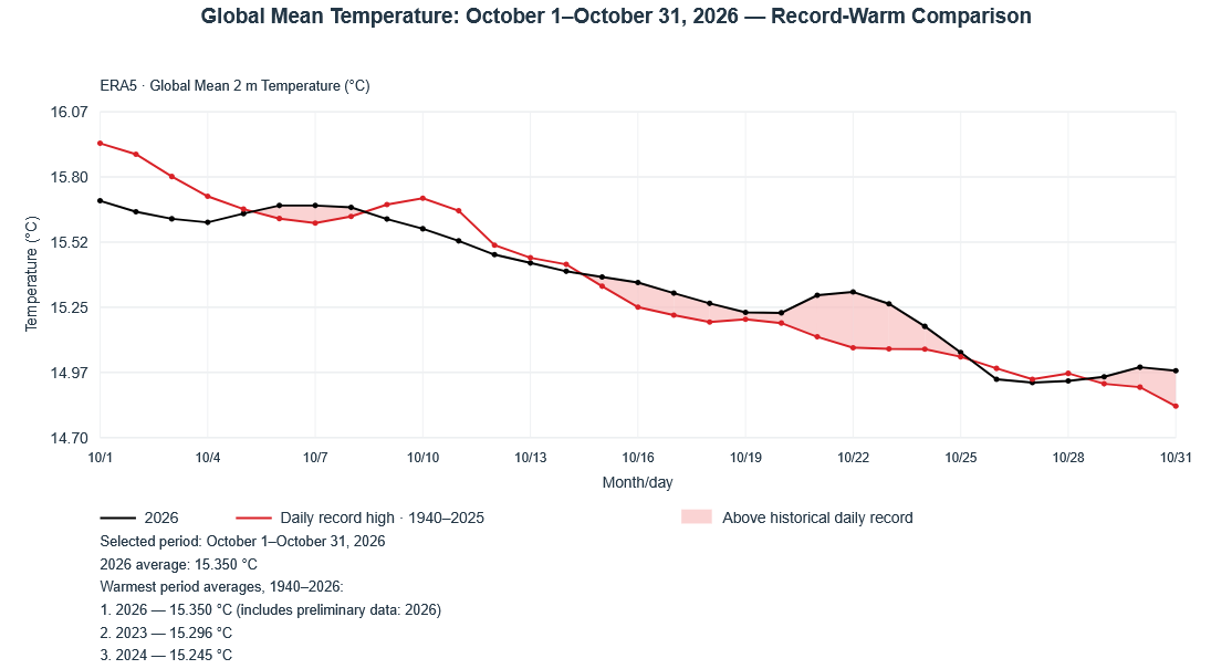
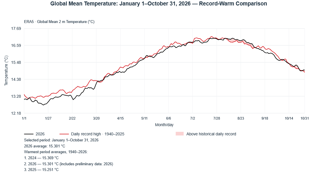
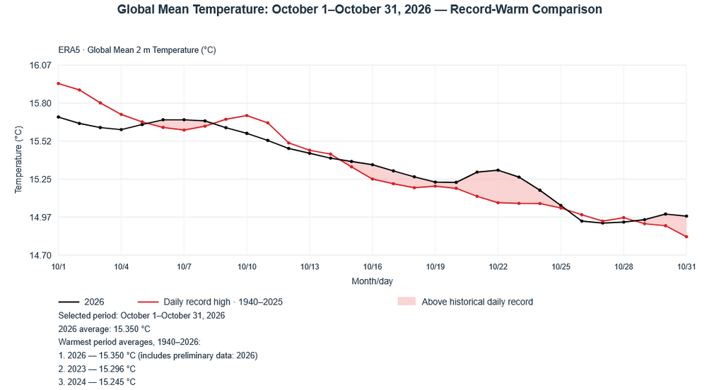
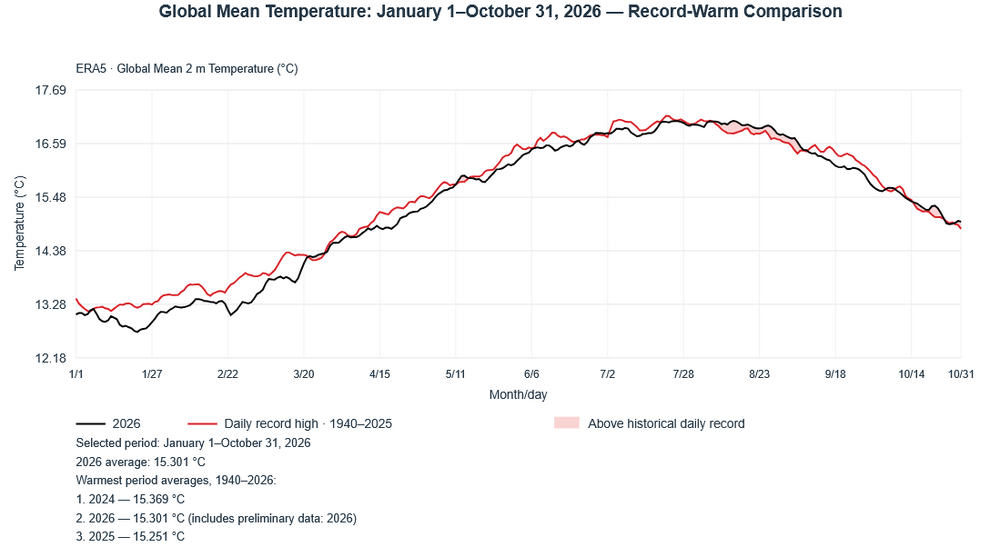
The preliminary global mean surface temperature for October 31 was 14.980C. That would break the daily mark of 14.831C from 2024. October 2026 finished as the warmest October on record. Following the record warm October, 2026 ranks as the second warmest year on record (ERA-5).
-

2026-2027 Record-breaking El Nino
snowman19 replied to Stormchaserchuck1's topic in Weather Forecasting and Discussion
And looking at 3.4’s absolute temperature, it is over 30C (over 86F) for weeks now, which is the highest ever in recorded history… -
Going to miss the 30 inch snowfall maps
-
November 2 1938: A tornado touches down at Nashwauk in Itasca County. Many livestock killed. 1842: A mild spell occurs at Ft. Snelling, where the temperature rises to 60 degrees. For Monday, November 2, 2026 1946 - A heavy wet snow began to cover the Southern Rockies. Up to three feet of snow blanketed the mountains of New Mexico, and a 31 inch snow at Denver CO caused roofs to collapse. (David Ludlum) 1961 - The temperature at Atlanta, GA, reached 84 degrees to establish a record for November. (The Weather Channel) 1966 - A storm brought 18 inches of snow to Celia KY in 24 hours. It tied the state 24 hour snowfall record first established at Bowling Green. (The Weather Channel) 1987 - A dozen cities, mostly in the Ohio Valley, reported record high temperatures for the date. Record highs included 83 degrees at Paducah KY and 84 degrees at Memphis TN. Temperatures reached 70 degrees as far north as southern Lower Michigan. Showers and thundershowers over southern Florida, associated with a tropical depression, produced 4.77 inches of rain at Tavernier, located in the Upper Florida Keys. (The National Weather Summary) (Storm Data) 1988 - A very intense low pressure system brought heavy rain, snow, and high winds, to parts of the northeastern U.S. Portland ME established a record for November with 4.52 inches of rain in 24 hours, and winds along the coast of Maine gusted to 74 mph at Southwest Harbor. Heavy snow blanketed parts of northern Vermont and upstate New York, with 15 inches reported at Spruce Hill NY. (The National Weather Summary) (Storm Data) 1989 - Squalls in the Upper Great Lakes Region the first three days of the month buried Ironwood MI under 46 inches of snow, and produced 40 inches at Hurley WI. Arctic cold invaded the Southern Plains Region. Midland TX reported a record low of 22 degrees. (The National Weather Summary) (Storm Data) Observances: 2 Mon Job Action Day 2 Mon International Day to End Impunity for Crimes against Journalists 2 Mon Recreation Day 2 Mon All Souls' Day 2 Mon Arrival of Indentured Labourers 2 Mon Be the Impact Day 2 Mon Broadcast Traffic Professionals Day 2 Mon Dynamic Harmlessness Day 2 Mon Look for Circles Day 2 Mon National Deviled Egg Day 2 Mon National Ohio Day
-
Sad day
-
 https://apexrxdirect.shop/# new pharmacy online
-
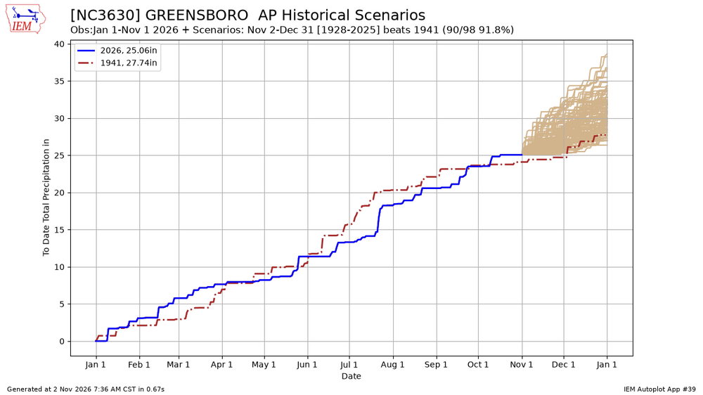
With the long range drying out considerably, we now look to come close to the driest year on record at GSO
-
2026-2027 Record-breaking El Nino
GaWx replied to Stormchaserchuck1's topic in Weather Forecasting and Discussion
The new NOAA relative weeklies are out and the record strong east basedness persists with only 3.4 not rising: 23SEP2026 3.9 3.1 2.2 0.1 30SEP2026 4.5 3.3 2.3 0.1 07OCT2026 4.4 3.4 2.4 0.2 14OCT2026 4.4 3.5 2.4 0.0 21OCT2026 4.4 3.6 2.5 0.0 28OCT2026 4.6 3.7 2.5 0.2 -Nino 1+2, 3, and 3.4 are far above any other on record for the week. -Nino 1+2’s +4.6 ties with 6/29/1983 for the all-time record for any week. -Nino 3’s +3.7 is a new record high for any week beating last week’s and 12/29/1982’s +3.6. -Nino 3.4’s +2.5 is a new record high for the week beating the +2.1 of 2015 -Nino 3.4’s highest for any week is +2.9 of 12/29/1982. There’s still no guarantee that will later be exceeded though there’s a good chance as of now. -
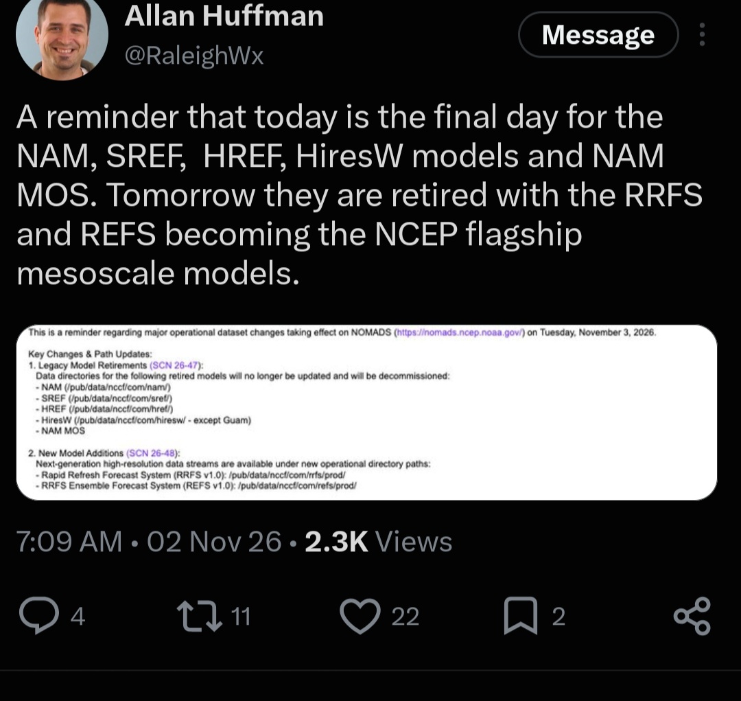
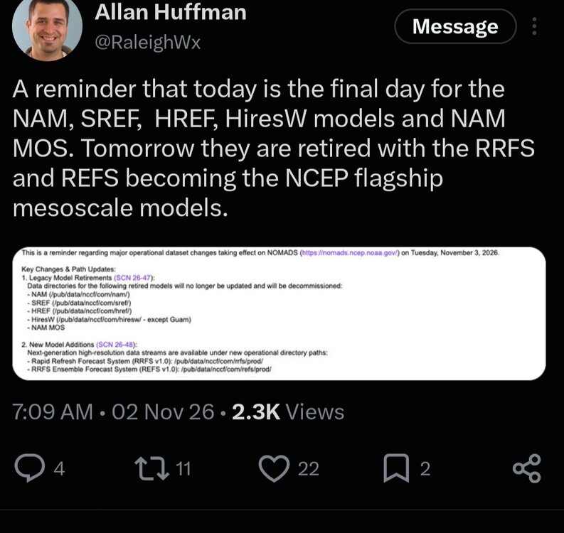
Here’s to the NAM [emoji1634] Rip .
-
Sad day
-
Gorgeous
-
2026-2027 Record-breaking El Nino
snowman19 replied to Stormchaserchuck1's topic in Weather Forecasting and Discussion
Regardless of the actual +IOD raw numbers, there is very clear +IOD forcing present on the OLR and VP charts. So the atmospheric coupling is there, which is what is important. It would be impossible not to have a +IOD with a Nino this insanely strong, it causes one to develop. It’s not going to make any difference in the strength of this Nino, nor how well it is and has been coupled. We are light years stronger than 2015, 1997, 1982 and 1972. It’s not even remotely close. This Nino has already secured its place as the strongest event in history and it’s going to increase its strength even more into December -
NAMS are being retired today after a long delay
-
Wild, I’ve had probably 10 mornings in the 20’s.
-
2026-2027 Record-breaking El Nino
GaWx replied to Stormchaserchuck1's topic in Weather Forecasting and Discussion
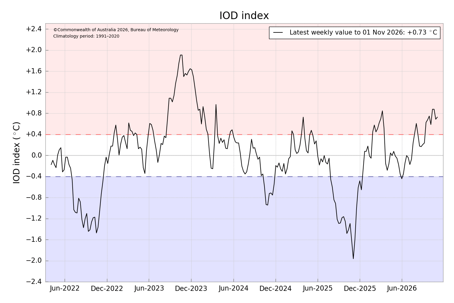
But in terms of the IOD, Oct of ‘26 though solidly positive was very underwhelming in comparison to 2 recent years per the weekly readings: 10/2026 ~0.76 10/2019 ~1.83 10/2023 ~1.74 10/2015 ~0.83 The latest weekly bounced back only slightly from 0.69 to 0.73. At this time in these years it was much higher: 2023: 1.5 2019: 1.7 Typically, this peaks by Nov. So, if it doesn’t jump sharply within the next few weeks it very likely will never do so this Nino per past patterns. https://www.bom.gov.au/clim_data/IDCK000072/iod_1.txt?1793622027272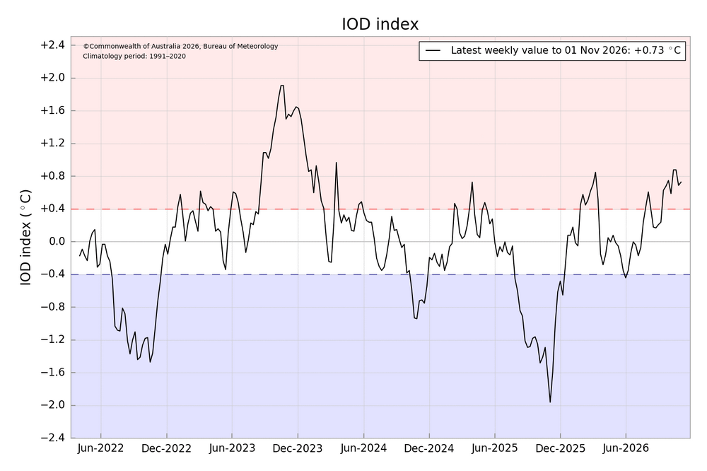
-
The color of the sky this morning had a profound effect on the color of the leaves.
-
@psuhoffman Take a look at the latest CFS run on pivotal.
-
antibiotic without presription or Over the counter antibiotics for infection otc antibiotics https://images.google.com.sv/url?q=https://antibiofastdirect.com antibiotic without presription or https://gikar.it/user/bqnrhehdhp/ buy antibiotics online safely [url=https://megalodon.jp/?url=https://antibiofastdirect.com]antibiotics online purchase[/url] prescription antibiotic or [url=http://lenhong.fr/user/zcvzepmgyr/]buy antibiotics from india[/url] buy antibiotics over the counter
-
BWI: 5” DCA: 3” IAD: 7” RIC: 9” Tiebreaker SBY: 3” Southern slider gives RIC the W
-