All Activity
- Past hour
-

2026-2027 Record-breaking El Nino
bluewave replied to Stormchaserchuck1's topic in Weather Forecasting and Discussion
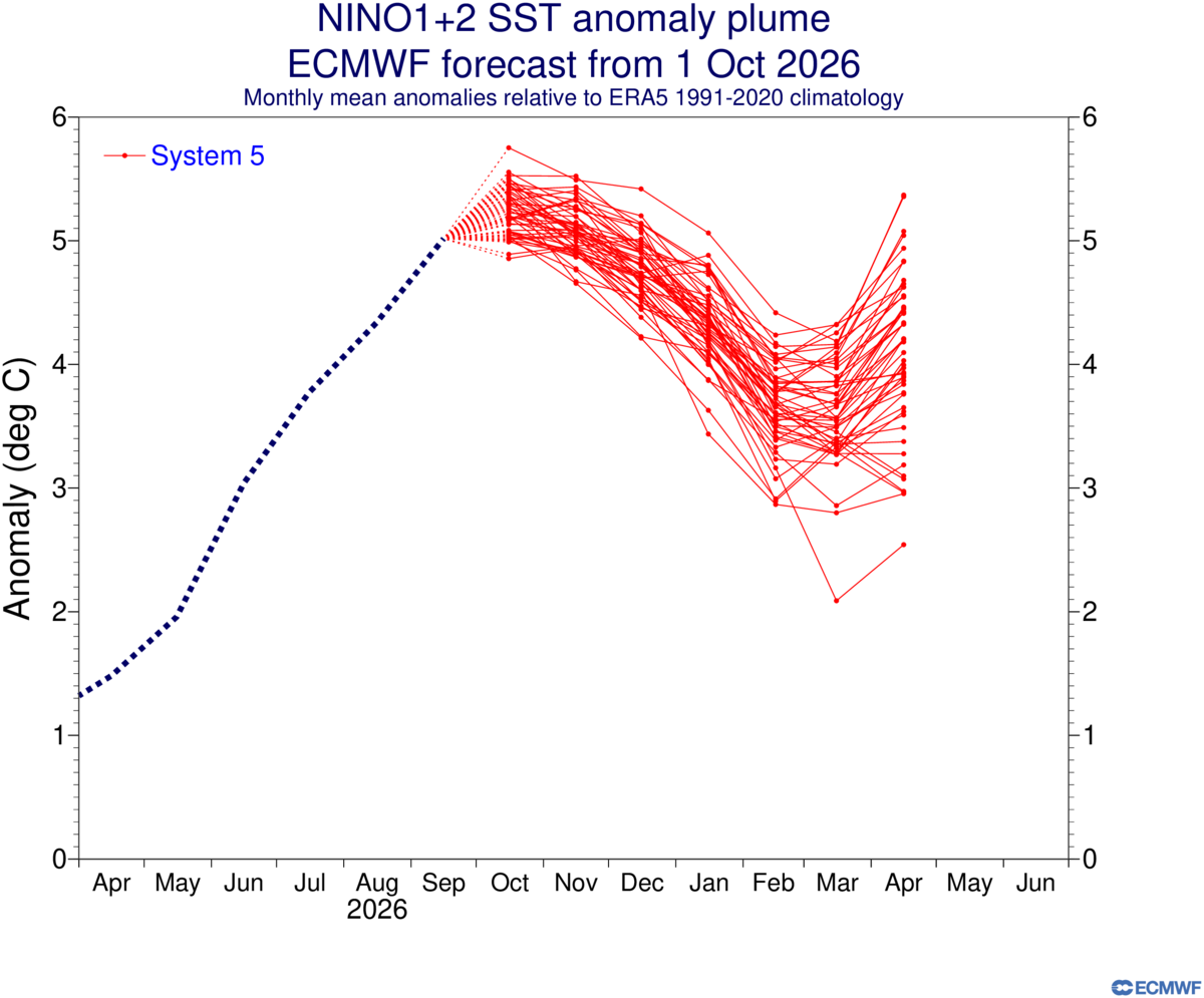
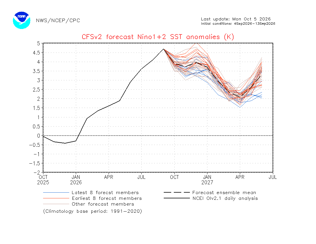
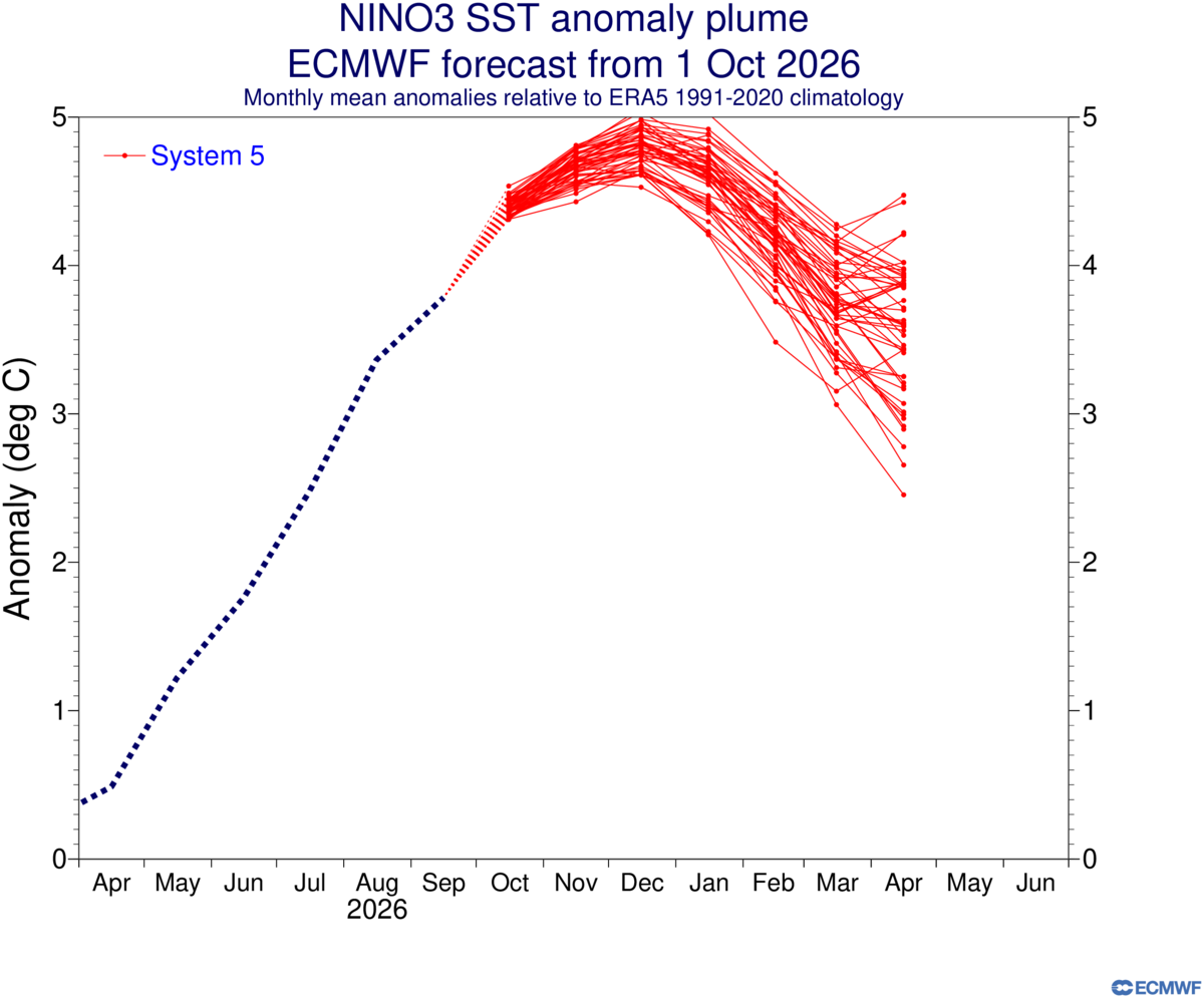
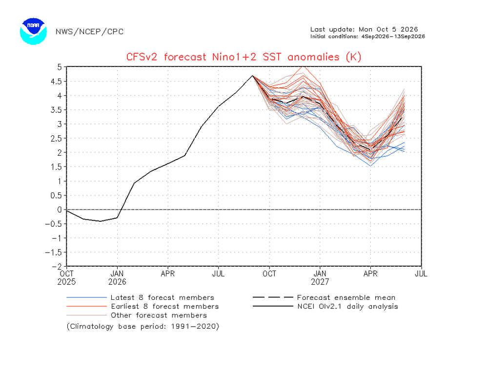
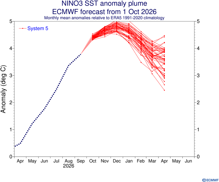
All-time records continue to increase. This was the first +5.3 week ever for Nino 1+2 ONI. Nino 3 and 3.4 records are also being set. Highlighting 1+2 due to how low the models have been here. While the Euro is much better than the CFS, they both missed how east based this has become. The interesting thing about both models is that they start to show a second rise in Nino 1+2 heading into next spring and early summer on the CFS. The Euro October update was just issued. Nino 3 staying above +4 into February would also be a first . https://www.cpc.ncep.noaa.gov/data/indices/ 30SEP2026 26.1 5.3 29.0 4.0 29.9 3.2 29.9 1.2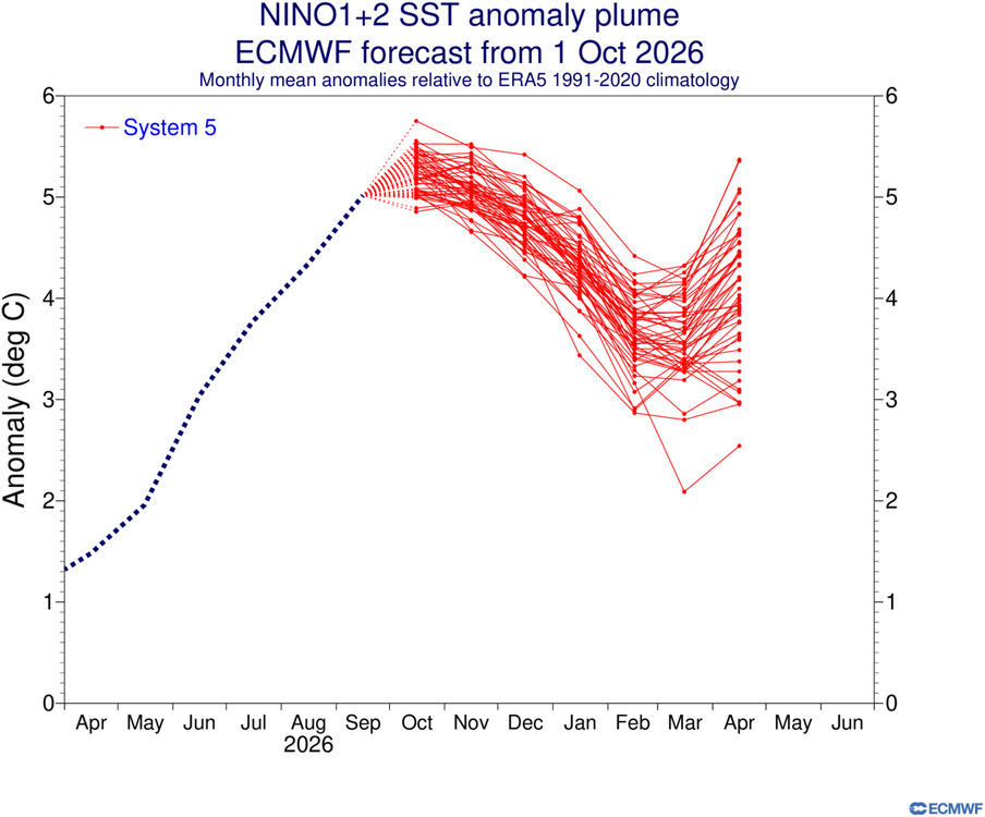
-

2026-2027 Fall/Winter Mountain Thread
Moonhowl replied to BlueRidgeFolklore's topic in Southeastern States
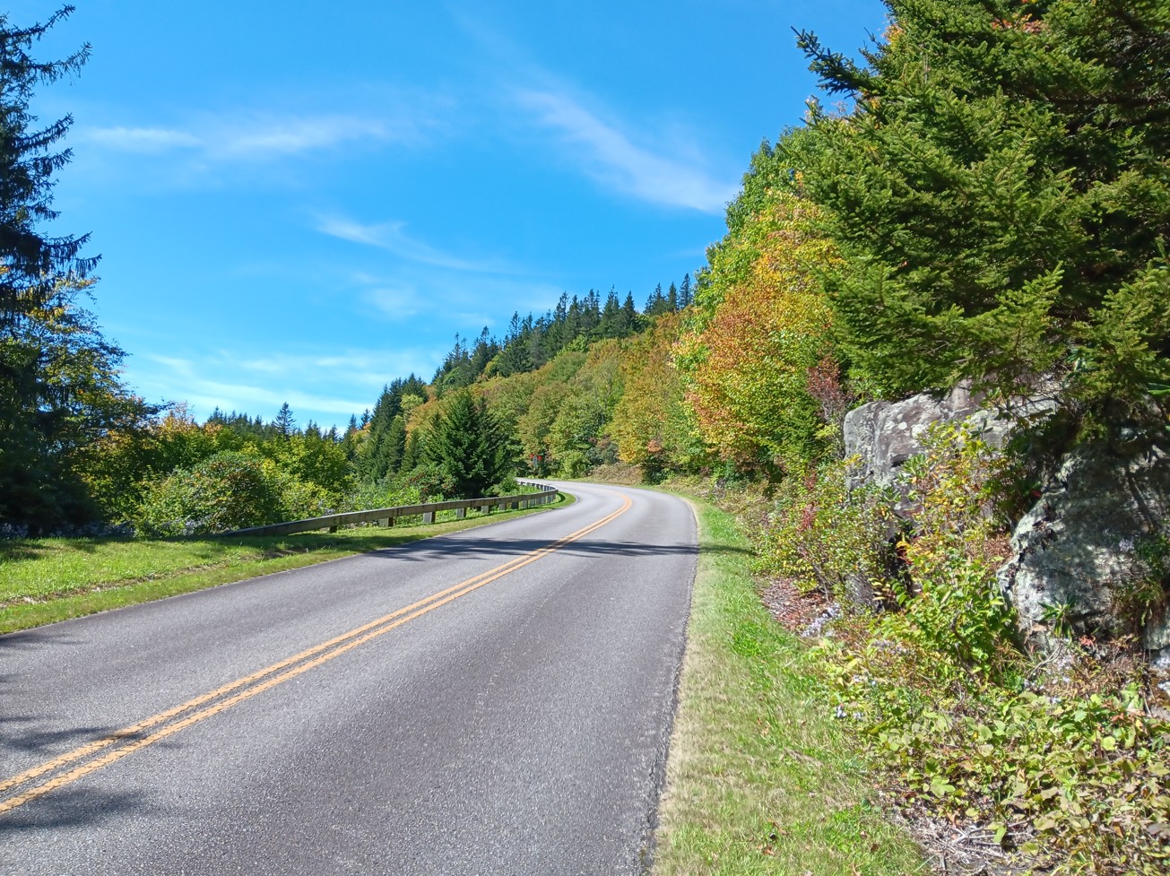
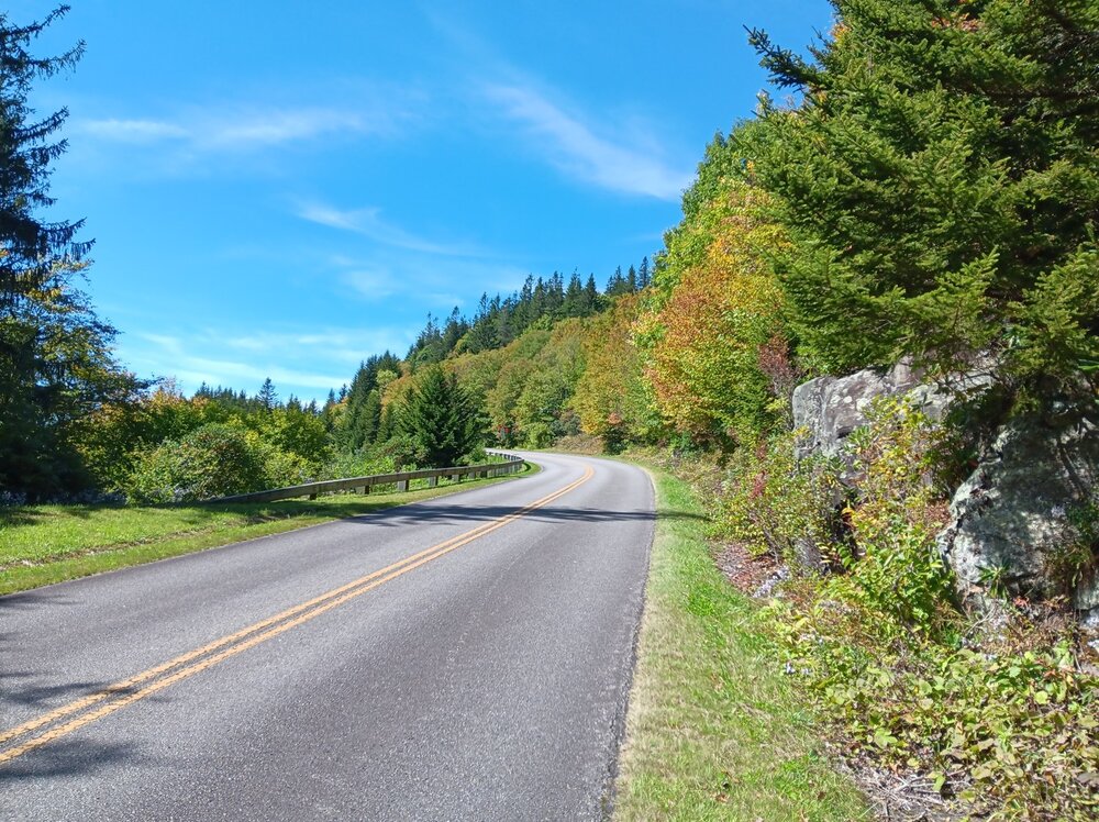
Cycled up Mt Mitchell the last day of September; a few shots of the fall color; one enhanced a bit by the morning sun: (maybe a quarter inch of rain; will be bone dry again around here in a few days)
-
Lawn thread And that burr looks a bit hybrid
-
Can’t wait! After 10 days in Vt/NH/Maine and with frost Sunday morning when we started heading south, I am looking forward to mid-Atlantic “heat”.
-

2026-2027 Record-breaking El Nino
40/70 Benchmark replied to Stormchaserchuck1's topic in Weather Forecasting and Discussion
Maybe, but I feel like the timing will be different this year....a more hostile December and a better for February. -

2026 Atlantic Hurricane Season
NorthHillsWx replied to Stormchaserchuck1's topic in Tropical Headquarters
One thing to watch is the EPAC cherry. If it becomes strong (like many models are showing) it’s outflow very likely contributes to increased shear in the gulf and could seriously inhibit that system -
Fog
-

2026-2027 Record-breaking El Nino
Terpeast replied to Stormchaserchuck1's topic in Weather Forecasting and Discussion
Looks a lot like 97-98 in terms of snowfall where the apps and interior get dumped on while coastal plains get below climo. But we only need one! (Speaking for the MA) -
So, the great Fall cooldown this week morphed into 2 days of normal temps followed by 3 more days of 80F.
-
Your trolling is growing on me
-
Tough not to be in that area when dealing with a true arctic airmass and NE winds.
-
2026 Atlantic Hurricane Season
NorthHillsWx replied to Stormchaserchuck1's topic in Tropical Headquarters
This one might deserve a thread since it will have at least some level of impact along the gulf coast -
 buy synthroid 125 mcg and synthroid 25mcg price synthroid 150 mcg dosage buy http://cttpeseux.ch/romands/link.php?url=http://thyrowellrx.com purchase levothyroxine tablets onlineand http://georgiantheatre.ge/user/yfpnmhiuln/ synthroid 200 mcg price per pill [url=https://www.google.ba/url?q=https://thyrowellrx.com]order levothyroxine 175 mcg[/url] discount synthroid pharmacyor [url=https://exhibitioncourthotel4.co.uk/user-2/ldanakgrmp/?um_action=edit]purchase levothyroxine tablets online[/url] generic synthroid for sale
 -
s tier color season incoming?
-
Hopefully Its weird not seeing any cold air anywhere in the long range gfs. I guess thats a Strong EL Nino for you.
-

Central PA Autumn 2026
Mount Joy Snowman replied to canderson's topic in Upstate New York/Pennsylvania
Low of 58 with .03" of rain from off-and-on all day drizzle yesterday. Looks like a splendid Fall week ahead. Onward. -
Now cherry (30%/70%): Tropical Weather Outlook NWS National Hurricane Center Miami FL 800 AM EDT Mon Oct 5 2026 Southwestern Gulf of America: A trough of low pressure in the southwestern Gulf of America is producing disorganized showers and thunderstorms. Although environmental conditions appear to be marginally conducive, gradual development is becoming more likely, and a tropical depression is likely to form during the middle or latter portion of the week. This system is expected to drift eastward over the next few days, before it turns northward. * Formation chance through 48 hours...low...30 percent. * Formation chance through 7 days...high...70 percent.
-
time to talk about snow that melted decades ago
-
Stein and boredom are back
-
http://isocleardirect.com/# generic isotretinoin tablets
-
Unfortunately it's that time of the year. URGENT - WEATHER MESSAGE National Weather Service State College PA 1233 AM EDT Mon Oct 5 2026 PAZ004-012-017>019-024-033-037-041-042-045-052000- /O.NEW.KCTP.FR.Y.0010.261006T0500Z-261006T1300Z/ Warren-Northern Clinton-Clearfield-Northern Centre-Southern Centre-Cambria-Somerset-Tioga-Northern Lycoming-Sullivan-Southern Clinton- Including the cities of Somerset, Trout Run, Laporte, Warren, DuBois, Renovo, Mansfield, Lock Haven, Johnstown, Wellsboro, Clearfield, State College, and Philipsburg 1233 AM EDT Mon Oct 5 2026 ...FROST ADVISORY IN EFFECT FROM 1 AM TO 9 AM EDT TUESDAY... * WHAT...Temperatures as low as 35 degrees will result in frost formation. * WHERE...A portion of central Pennsylvania. * WHEN...From 1 AM to 9 AM EDT Tuesday. * IMPACTS...Frost could harm or kill sensitive outdoor vegetation. PRECAUTIONARY/PREPAREDNESS ACTIONS... Those with agricultural interests should protect sensitive vegetation. Near-ground freezing temperatures could kill uncovered sensitive outdoor vegetation. The latest forecast information can be found on the NWS State College Facebook page and Twitter @NWSStateCollege, or on the web at weather.gov/ctp.
- Today
-
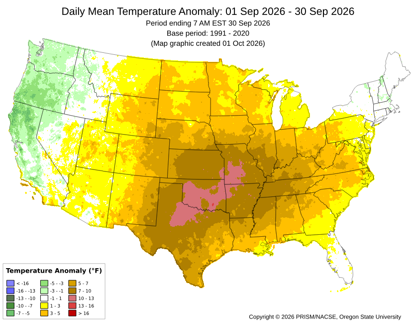
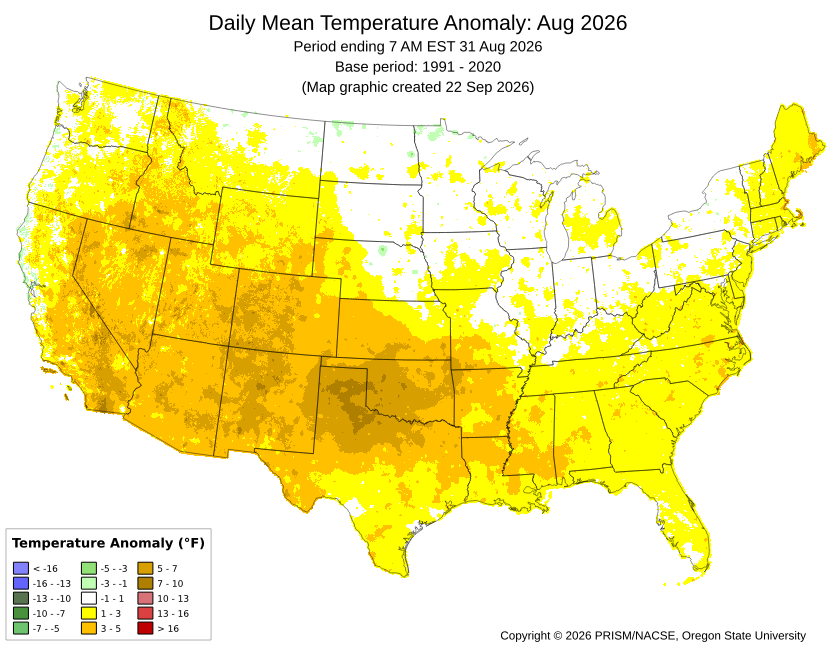
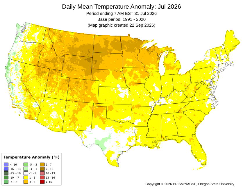
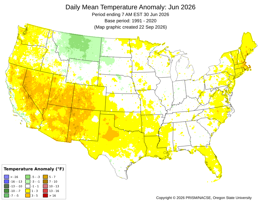
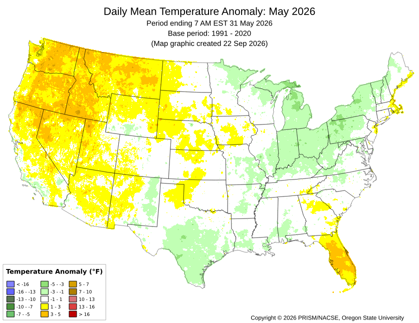
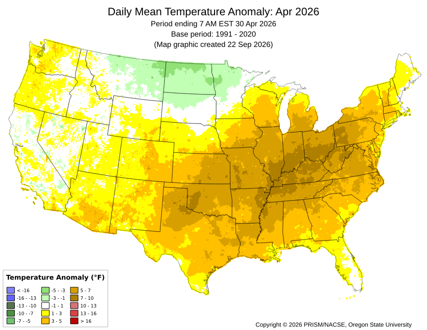
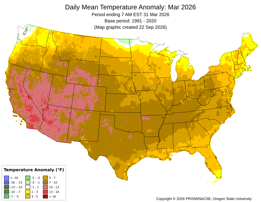
Last month was N to a little AN for most stations with the exception of the immediate Long Island Sound stations like BDR and LGA. All the other months back to March were also some degree of AN. With such extensive ridging and record CONUS warmth, there wasn’t much cooler air around. So the few cooler spots last month like LGA and BDR had to rely on lower daytime highs rather than cooler minimums. May managed to finish a little above even with the cooler conditions just to our West. The record warm day where parts of the area reached 100° for the first time in May put that month over the top. So the theme has been back and forth with the warmer departures being more impressive than the cooler ones. October looks like a continuation of the same theme. Very warm start to the month with a cool down this week. But we warm right back up into the 70s again. Whether we reach 80° again by mid-October will be contingent on sky conditions, wind direction, and how far north the moisture near the Gulf gets.
-
Drizzled/Misted all day and picked up .12. Finally was able to get in 2 baseball games.
-
Don't forget about 2002-03 to 2004-05. That was an epic 3-year stretch. Also, after 2009-10 and 2010-11, you had (after 2 lean years) 2013-14 and 2014-15 to complete the Big 4.