All Activity
- Past hour
-
 Post your Dec 2025 forecasts and add snowfall forecasts for the usual nine locations which I list below (three replace some of the warmer locations in our temperature contest, six are the same locations) ... TEMP _________DCA _ NYC _ BOS __ ORD _ ATL _ IAH __ DEN _ PHX _ SEA SNOW _______ DCA _ NYC _ BOS ___ ORD _ DTW _ BUF __ DEN _ SEA _ BTV (snowfall forecasts will include anything already measured and go to the end of the season which can be May for DEN at least) This post will be edited into the annual scoring update, as you can see the Nov 2025 scores are already tabulated in a preliminary form in the previous post above. ----------------------------- Try to post the temperature portion by the usual deadline of Dec 1 06z, I can wait for the snowfall forecasts for a few days into December. Happy Thanksgiving.
 - Today
-

Nov 28-30th Post Turkey Day Wintry Potential
KeenerWx replied to Chicago Storm's topic in Lakes/Ohio Valley
Fun to track, but hard to tie any excitement locally. No real science applied to the “pessimism”, just erring on side of climo and the many fail modes favored at my specific location. On the other hand, lucked out on a record event earlier in the month. So perhaps the wins can continue. I’d be happy to just see some more snow. But as a junkie for #’s, I’m looking at the thresholds of 2”+ & 5”+. The former is just cool and gets to double digit Nov snowfall. From what I can uncover, we’ve already surpassed any reasonable verifiable record for month. The latter would mean surpassing the individual seasonal totals of ‘23/‘24 & ‘24/‘25 by end of November. Which is both silly and awesome at the same time. -
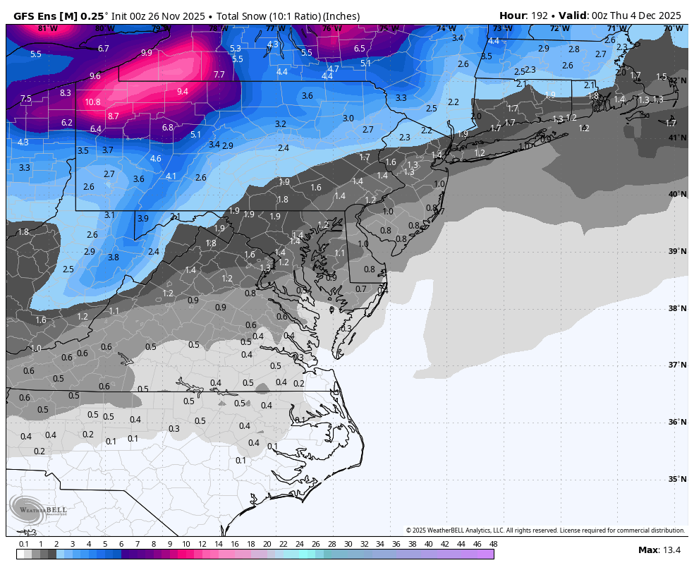
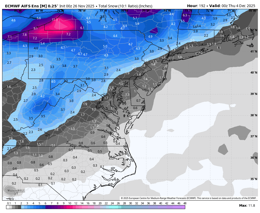
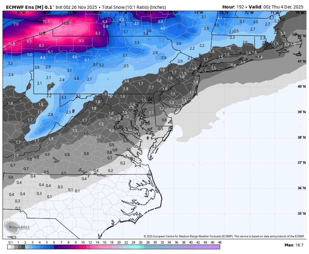
WB 0Z ensembles at Day 8.

-
The 0Z Euro starts as frozen in the metro BUT that HP does not stay anchored like in the GFS run so there is a change over to rain - still to early to predict the outcome except to say the storm chances are increasing and a frozen to rain scenario is favored right now IMO
-
The OZ UKMET looks to be a closer to the coast track as the HP in southeast Canada is not as strong - starting at least as Frozen in the metro - the Canadian and the Euro AI are offshore tracks
-

December 2025 regional war/obs/disco thread
Torch Tiger replied to Torch Tiger's topic in New England

-
EURO and the GFS both have snow next week.. its coming
-
The important feature is the strong enough cold enough HP in southeast Canada staying PUT long enough to keep feeding the cold enough air in and storm track is perfect Benchmark because of this
-
Hopium is strong in here, and I’m here for it! If anything December looks to feature some cold in the east and the southern stream looks to become active. Volatile seems like a good word
-

Nov 28-30th Post Turkey Day Wintry Potential
Malacka11 replied to Chicago Storm's topic in Lakes/Ohio Valley
Doing jah's work with these wbell posts -

Nov 28-30th Post Turkey Day Wintry Potential
Sciascia replied to Chicago Storm's topic in Lakes/Ohio Valley
I’ve been sidelined from work since November 6th dealing with a lower back injury. Things are looking good that I’ll be cleared tomorrow to go back to work on 12/1. So, of course, a potential winter storm may dump a foot right before I go back & my 20 year old Explorer is immediately put to the test. -

Nov 28-30th Post Turkey Day Wintry Potential
migratingwx replied to Chicago Storm's topic in Lakes/Ohio Valley
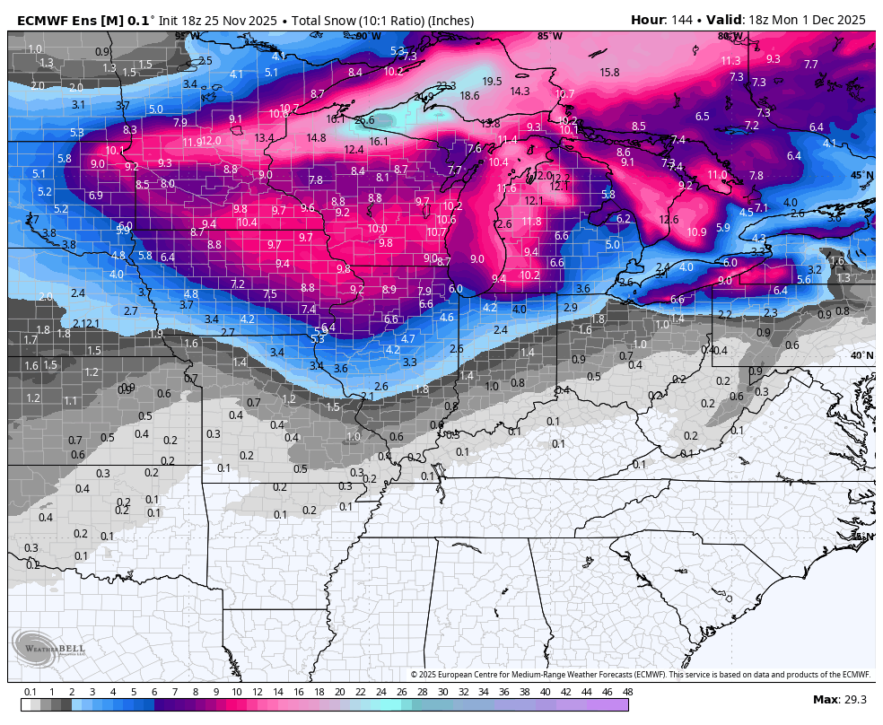
EPS mean also went up since the 18z run. 00z vs 18z below

-
Nov 28-30th Post Turkey Day Wintry Potential
migratingwx replied to Chicago Storm's topic in Lakes/Ohio Valley
Like the GFS, the Euro does have some marginal surface temps from about midnight to 6am Sunday morning from Chicago south and east. Temps aloft, however, looks to remain below 0°C during the event until you get south of Kankakee and into Indiana. At 925mb, this is the warmest frame. Air above that is solidly below 0°C.

-
Nov 28-30th Post Turkey Day Wintry Potential
migratingwx replied to Chicago Storm's topic in Lakes/Ohio Valley
Definitely! And thus, the totals ticked up decently from the 18z run.
-
December 2025 regional war/obs/disco thread
Torch Tiger replied to Torch Tiger's topic in New England
before reading, initial instinct was 2011-2012 lol. that's wild, forgot that happened. -

E PA/NJ/DE Autumn 2025 Obs/Discussion
LVblizzard replied to PhiEaglesfan712's topic in Philadelphia Region
0z Euro has it too. More of a hit for the LV/Poconos but it's there. -
We are in midseason form. Gfs big yes. Dr no big no
-
Oh Im at hour 144 and thought it might be a bit better
-

Nov 28-30th Post Turkey Day Wintry Potential
sbnwx85 replied to Chicago Storm's topic in Lakes/Ohio Valley
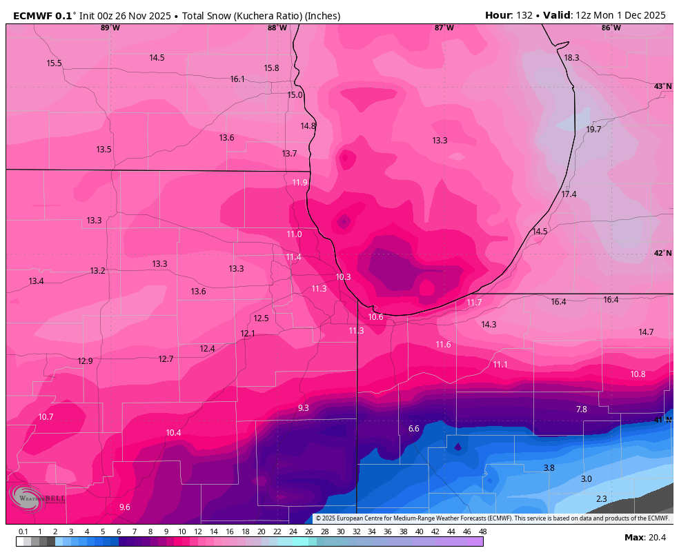
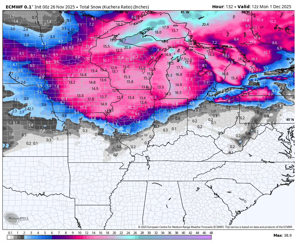
Euro nudged south. We are right back in this ballgame. -

December 2025 Short/Medium Range Forecast Thread
John1122 replied to John1122's topic in Tennessee Valley
The GFS ended up with multiple fronts and a couple of shots of wintery precip for the forum area. -
-

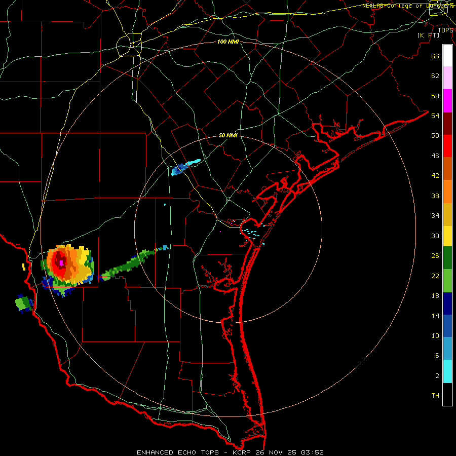
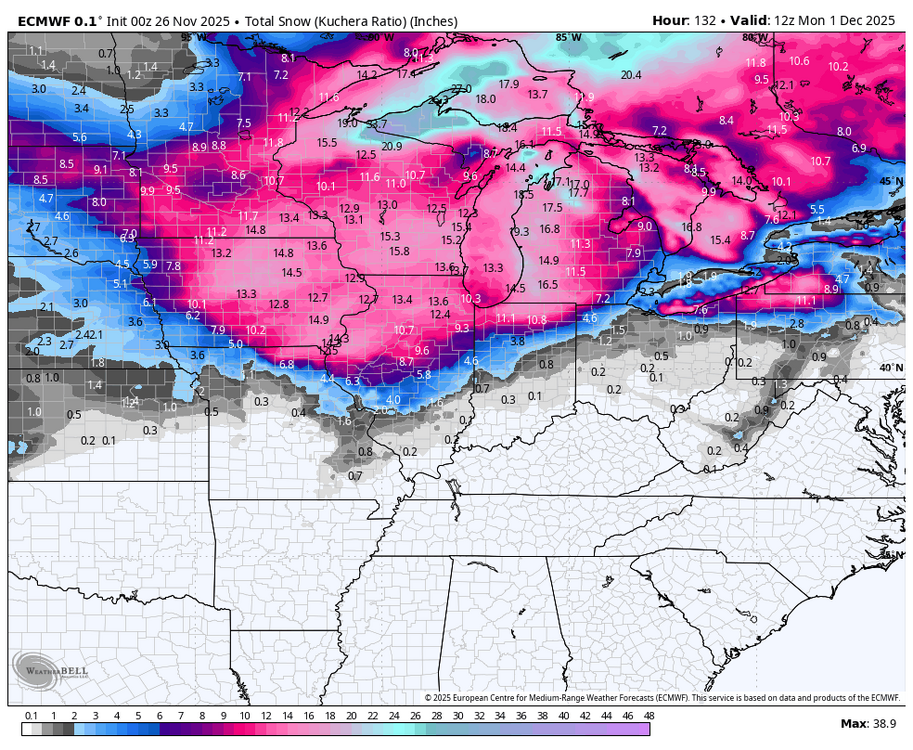
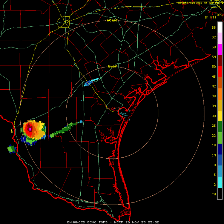
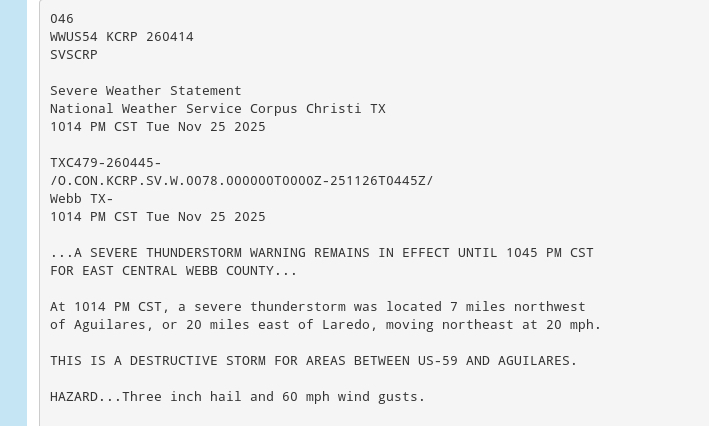
Texas 2025 Discussion/Observations
Stx_Thunder replied to Stx_Thunder's topic in Central/Western States
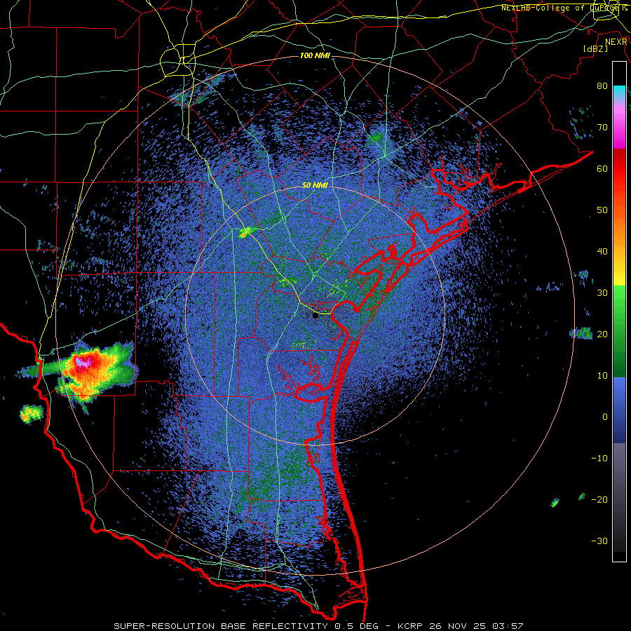
'Next to December now. And still got 3+ in. hailers (and likely over 80 DBZ reflectivity and 55 Kft storm tops), in the state tonight..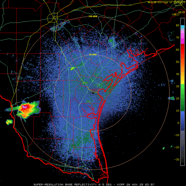
-
AIFS suppressed. Toss. EURO amped. Average them out
-
Central PA Fall Discussions and Obs
mitchnick replied to ChescoWx's topic in Upstate New York/Pennsylvania
Over in the MA forum. Sometimes I get lost... -
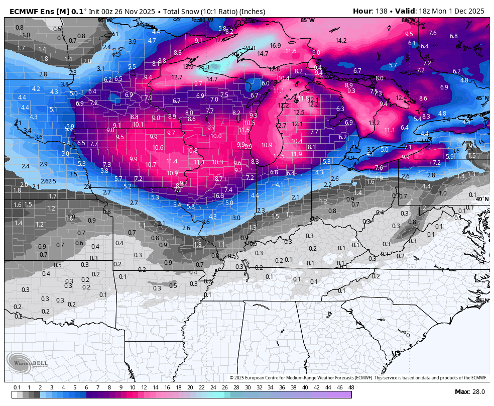
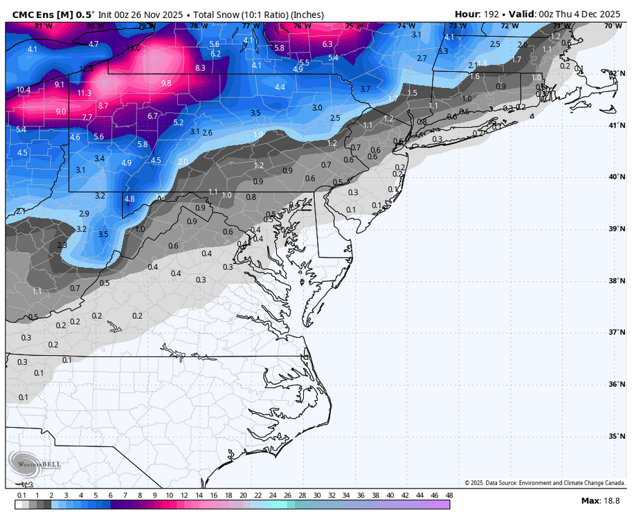
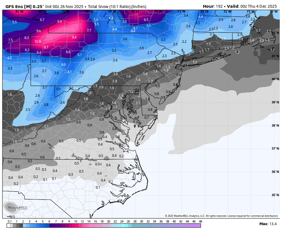
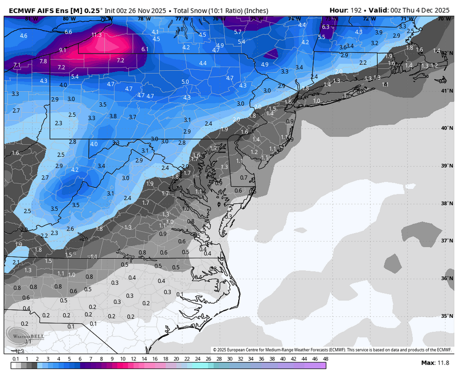
Where is the snow map?