All Activity
- Past hour
-
Historic MI footage. Near the start you can see some of the ice getting pulled in to the vortex (looks like water with that low res video), another first! Also the longest weather streak I'm aware of may have just ended this afternoon (no confirmed violent tornadoes in MI since 1976 (West Bloomfield F4) or the Augusta 1977 one (unsure)).
-

Winter 2025-2026 Offers Return to Normalcy
40/70 Benchmark replied to 40/70 Benchmark's topic in New England
Rough Friday AM Commute But Even Rougher Forecast Conservative Course Of Least Regret In Marginal Soundings While the commute this morning undoubtedly left something to be desired, it was the Friday morning forecast that was a metaphorical 30-car-pileup, which ironically enough was a fortuitous break for area commuters. Obviously the forecast for 3-6" of snowfall over northeastern Mass and much of southern New Hampshire verified as a mere 1-2" of sleet and assorted snow grains. The reason for this is quite simple. Here is the sounding, which is a profile of the temperatures in degrees celsius throughout the atmosphere, from Lawrence, MA at 1AM Friday morning. Note the tiny area of the atmosphere near freezing at around the 850mb level (5, 000 feet), right as precipitation was forecast to transition to a period of accumulating snowfall for several hours through to the morning commute. This is also evident in the excerpt of the text data from the 850MB level below, as the temperature is pinned right at freezing at this level from 10PM through 4AM, while the rest of the profile is below freezing. The forecast for 3-6" of snow was based off of guidance that implied that snowfall rates would be heavy enough to evaporatively cool this layer, while also allowing the snow to fall through it with enough haste to avoid melting. This was always a precarious position best reserved for instances in which the antecedent airmass is very cold, such as Tuesday's over performing snowfall. Ultimately, the flakes ended up being compromised enough by this layer that they were largely relegated to sleet and poorly developed snow flakes referred to as "grains", both of which accumulate extremely inefficiently. Whereas normal snowfall accumulates about 10" for every inch of liquid that falls, this type of frozen precipitation only accumulates approximately 3" for every inch of liquid, which is why an inch or two of sleet fell as opposed to between 3 and 6" of snow. Final Grade: F -
Terrible forecast for this morning, but I'm sure that most commuters will forgive me considering that it wasn't nearly as miserable as feared. Culprit (savior) was a very narrow, marginal warm layer at about 5,000 feet up in the atmosphere....while that can be overcome at times, ultimately in this case there just wasn't a cold enough air mass in place to begin with and precipitation wasn't consistently intense enough. Last Tuesday, there was a very cold airmass in place beforehand, which aided snowfall. Have to grade this one an "F". Judging by my last couple of forecasts, I'm ready for spring, but Mother Nature has other ideas after next week's tease. FINAL GRADE: F
-
Let’s do it. That 3/16 date keeps showing up…
-
Awesome timing! The 17th is town election day in rural NH: school boards, etc.
-
You and dad go chase.…
-
Missouri and Kansas might go off soon already been tornados in Michigan and Oklahoma today
-
Unreal 85F at 2:34pm. must....not...turn....on ... A/C.....
-
I had some good 12-18" drifts.
-

Central PA Spring 2026 Discussion/Obs Thread
Blizzard of 93 replied to Voyager's topic in Upstate New York/Pennsylvania
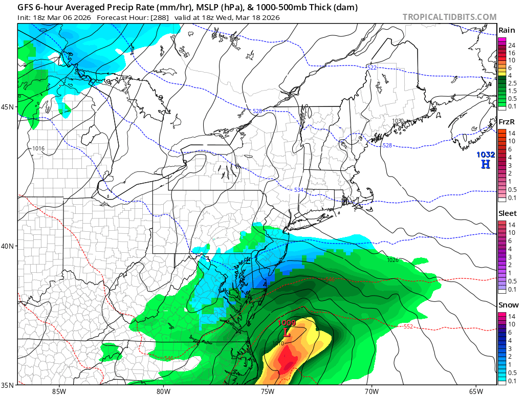
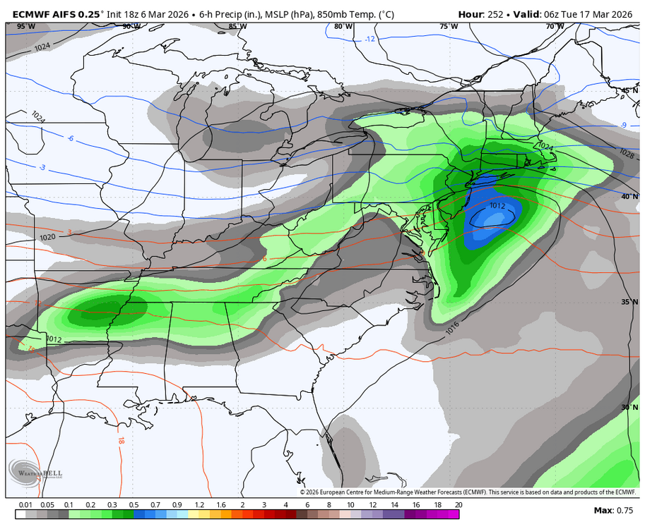
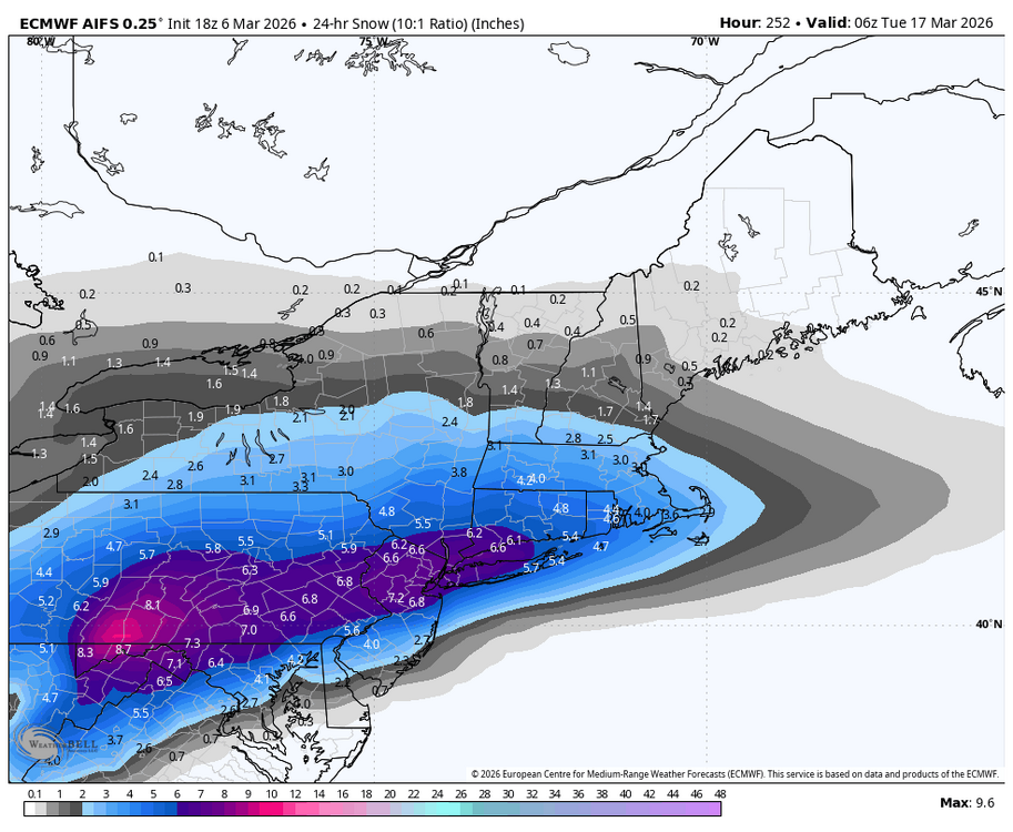
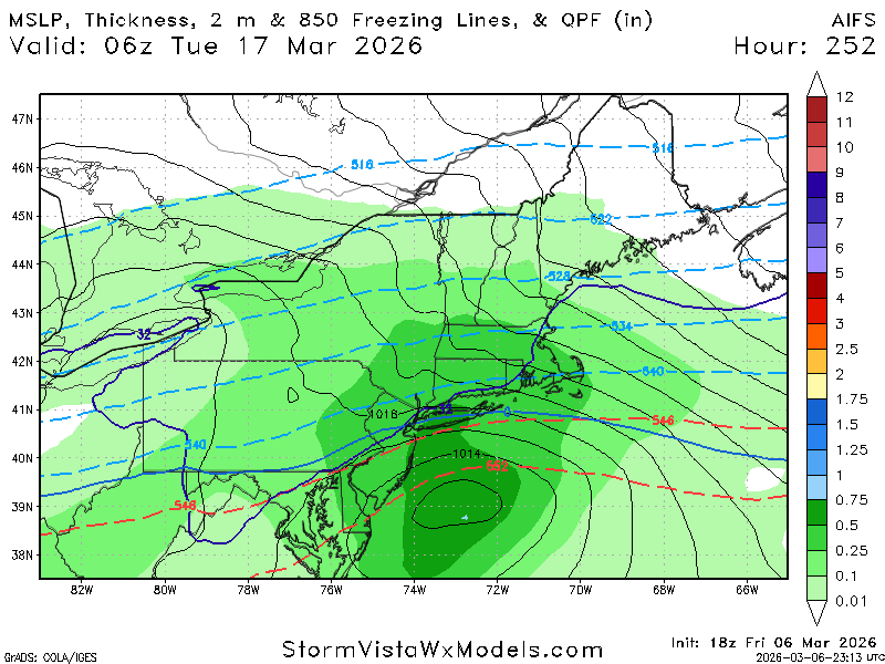
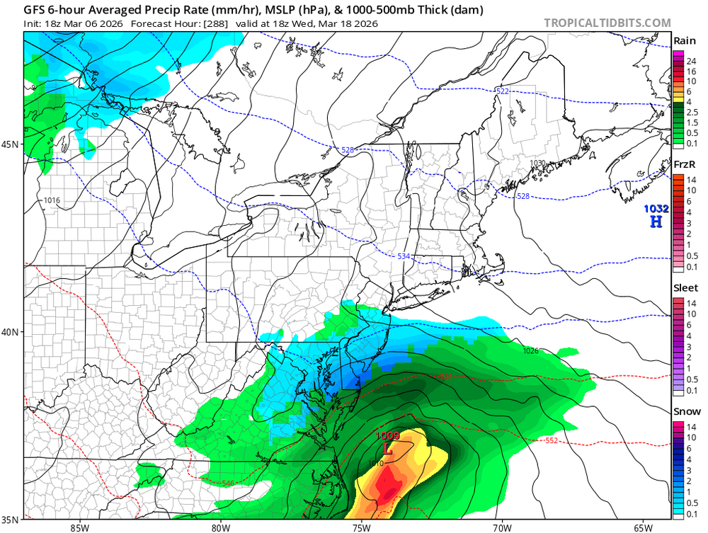
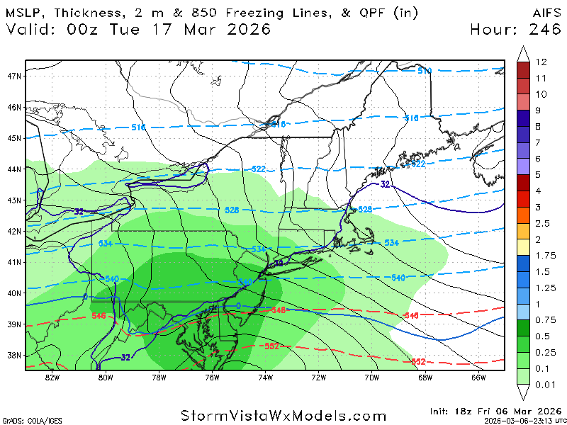
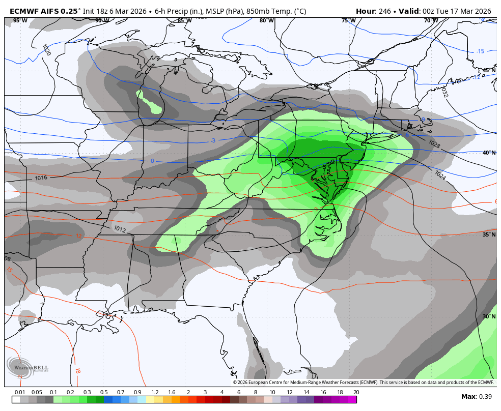
18z Euro AI delivers the Happy hour goods just in time for St. Patty’s Day!

-
Would be cool to get to 80”.
-
18z Euro AI delivers the Happy hour goods just in time for St. Patty’s Day!
-

Mountain West Discussion
mayjawintastawm replied to mayjawintastawm's topic in Central/Western States
I have 7.8" on my snow board now, flat sheltered area with no drifting. Wow! Still accumulating a little. We had a good 1"/hr band from about 7:30-11:30 and steady light to moderate snow since. -
Keep denying the colder trend. This has been happening all winter. Soon or later the warmth will win out but not now.
-
we call that Seasons in Seasons.
-
Tired of my fingers and toes being chilly. I only got up to 51.
-
might see a blizzard on the 4th of July
-
1 more time Gfs also tries to spin up a coastal


-
The coverage is low due to the best forcing lagging farther west (where overnight crapvection muddied things), but I feel like high end potential deserves a watch. Especially in southern Michigan where the population isn’t exactly sparse. The parameters were certainly there for a strong tornado, even if the models weren’t firing convection at that time.
-
One last chance during this timeframe and thats it.

-
April
-
Gfs is getting colder in the mid range like the Euro.
-
Today was a fluke, but it goes to show why the new SPC format is flawed trash. The science is currently not good enough and never will be good enough to set a min/max on hail size, wind speed and tor strength in outlooks and MD's.
-
Reminds me of the 2011 Tuscaloosa–Birmingham tornado or the El Reno tornado in 2013 that everyone hates talking about. Hopefully the injured recover, but my god... I hate those multi-vortex tornadoes that have those "arms." Those are some of the most violent tornadoes out there.
-
Central PA Spring 2026 Discussion/Obs Thread
Blizzard of 93 replied to Voyager's topic in Upstate New York/Pennsylvania
I’m looking forward to our 3 or 4 day warm up while actively tracking snow chances around St.Patty’s Day! I am hunting that 6.2 of snow to get MDT to climo seasonal average!


.thumb.png.4150b06c63a21f61052e47a612bf1818.png)