All Activity
- Past hour
-
NWS mentioned in their discussions that another closed low looks increasingly likely the middle of next week. I'm so over this weather pattern.
-
.07 today. More to come.
-
Meanwhile in Floridah, 100-105F Heat Index for the past several days. Don't mind the heat it's always been the humidity, 70-75Dews. Rain season delayed but should start a in week which is later than climo. Last CF of the season "washing-out" leaving behind just enough instability, to generate sea-breeze convergence. U can set your watch by them 4-6pm, everyday.
-
The line that just came through here had some juice with it. Very little T&L but brief torrential rains. 0.79" on the day with 0.56" coming with that line in probably 15 minutes.
-
Same here. Heavy drizzle! Hasn't even added a hundredth to the meager total lol.
-
https://easternmassweather.blogspot.com/2025/05/modest-cool-enso-influences-may-persist.html
-
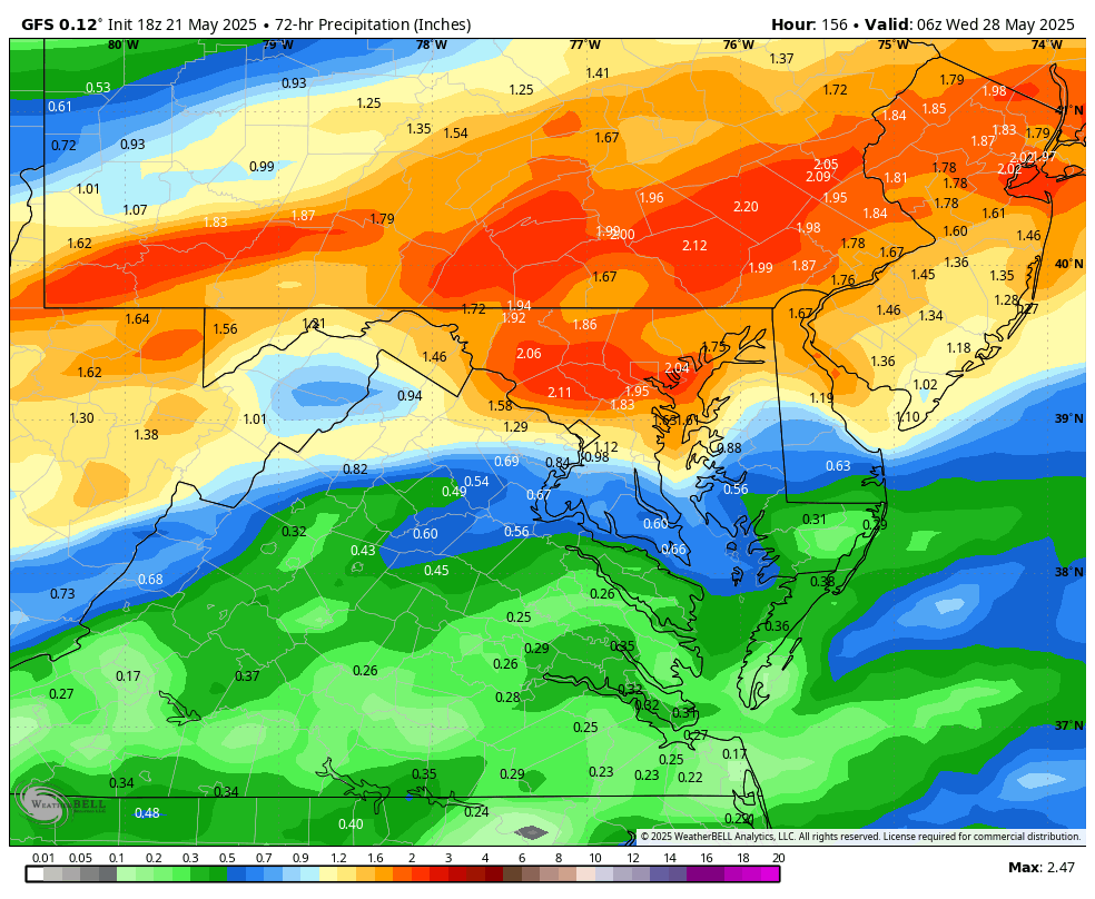
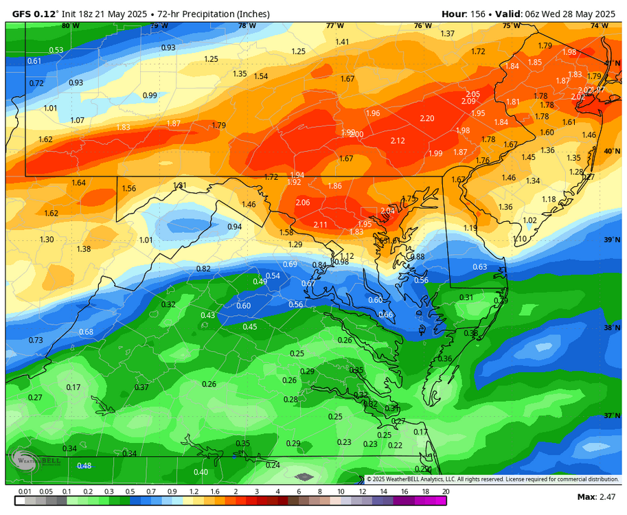
WB 18Z GFS....brings the rain back by early evening on Monday in Western zones.
-

2025-2026 ENSO
40/70 Benchmark replied to 40/70 Benchmark's topic in Weather Forecasting and Discussion
https://easternmassweather.blogspot.com/2025/05/modest-cool-enso-influences-may-persist.html -
Tonight and tomorrow will be rainy and exceptionally cool for this time of year. A storm total 0.50"-1.50" rainfall is likely into Friday morning. Temperatures will top out in the lower to middle 50s in New York City tomorrow. Tomorrow's record low maximum temperature is 54° from 1894. That mark could be challenged. The below normal temperatures could persist into early next week. However,it could turn noticeably warmer during the closing days of the month or opening of June. Showers could persist into Friday. It is likely that New York City will see the mercury dip below 50° on Thursday night and Friday morning. The ENSO Region 1+2 anomaly was 0.0°C and the Region 3.4 anomaly was +0.1°C for the week centered around May 7. For the past six weeks, the ENSO Region 1+2 anomaly has averaged +0.55°C and the ENSO Region 3.4 anomaly has averaged -0.07°C. Neutral ENSO conditions will likely continue through at least mid summer. Early indications are that summer 2025 will be warmer than normal in the New York City and Philadelphia areas. The potential exists for a much warmer than normal summer (more than 1° above normal). The SOI was -3.58 today. The preliminary Arctic Oscillation (AO) was -0.328 today. Based on sensitivity analysis applied to the latest guidance, there is an implied near 50% probability that New York City will have a warmer than normal May (1991-2020 normal). May will likely finish with a mean temperature near 63.2° (normal).
-

E PA/NJ/DE Spring 2025 Obs/Discussion
ChescoWx replied to PhiEaglesfan712's topic in Philadelphia Region
What's old is new and that old cyclical climate change is no doubt coming back around for future generations to enjoy!! Can the cold of the 1970's be far behind us?? -
Another 0.30" today brings us to 2.20" for the 3-day total. Only made it to 54 this afternoon under the heavy overcast. Hard to believe we hit 95 6 days ago.
-
Heavy rain showers moving through....enough to wash in my late spring lawn treatment! (HRRR forecast from the am did a good job...)
-

Central PA Spring 2025
Mount Joy Snowman replied to canderson's topic in Upstate New York/Pennsylvania
Well under a tenth of an inch down here but the good stuff seems to be on the way. -
.15” rain so far today. 54 is the high.
-
Luckily just oaks surrounding me. The dongs are down for the most part.
-
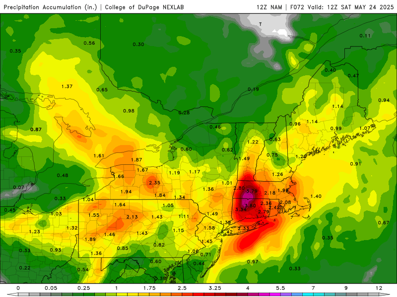
18z GEMLAM still pretty decent for our area. RGEM was east at 12z as well. But NAMS got heavier and more west compared to 12z.
-
I think NY has enough laws and regulations on the books as it is lol
-
Likely just bring more seeds from your neighbor's trees to your lawn.
-
Biggest load of horse s*** . People have eyes, they can see full ponds and running streams.
-
Hopefully some more Norways are brought down.
-
Cook something. Putting something in the oven does a remarkably good job of heating up a house, especially if it's something like a condo.
- Today
-
How often we get perfect timing in the winter? I would take this any day of the week in January or February.
-
my condo turns the heat off may 5th every year. its brick in here rn. dreaming of san diego now. this is absurdity
-
Wow!
-
This was the 12z run, 18z backed off quite a bit but still has a large of 2"+ and by large swath I mean basically all of CT/RI/MA with totals approaching 3" in southern VT.


.thumb.JPG.418e8a9a2902ae687ec35ff4bc0e038e.JPG)