All Activity
- Past hour
-

Mountain West Discussion
gallopinggertie replied to mayjawintastawm's topic in Central/Western States
Wow, Miles City got up to at least 115 today and Billings 111. Both all-time highs by a margin of 3-4 degrees. -
 No flooding please.
 -
What a gorgeous day. Played 18 and then my wife and I cruised up Cold Hollow Cider Mill and looped back through Stowe and Morrisville for a late Sunday afternoon ride. Beautiful out.
-
 Nammy is hellacious
 -
 Figured @vortex95 would appreciate this SLC met using a photo of snowy mountains for the all-time hottest temperature since 1874… could’ve gone with flames and death, instead a tranquil April day photo of the Wasatch, lol.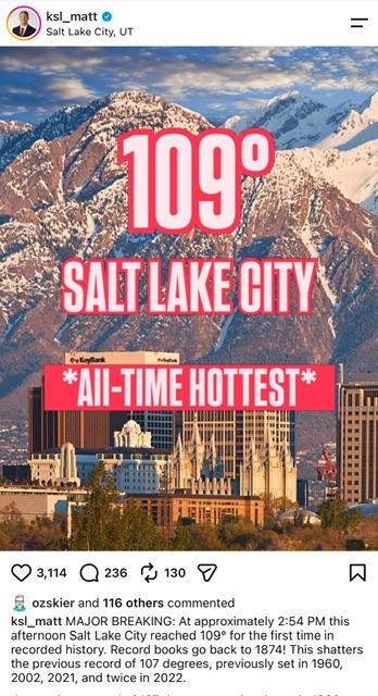
-

2026-2027 Super El Nino
LakePaste25 replied to Stormchaserchuck1's topic in Weather Forecasting and Discussion
that low west of the aleutians is something to watch since it actually has a meaningful correlation with less noise. -

2026-2027 Super El Nino
Stormchaserchuck1 replied to Stormchaserchuck1's topic in Weather Forecasting and Discussion
I'll go warmer on the August pattern This one has nothing to do with -NAO/AO -
Eventually it will. We need some all time all time out here.
-
2026-2027 Super El Nino
Stormchaserchuck1 replied to Stormchaserchuck1's topic in Weather Forecasting and Discussion
Looking like July is going to be the 6th straight month with -PNA (CPC) 2026 0.79 -0.56 -1.74 -1.26 -1.27 -0.50 -
2026-2027 Super El Nino
LakePaste25 replied to Stormchaserchuck1's topic in Weather Forecasting and Discussion
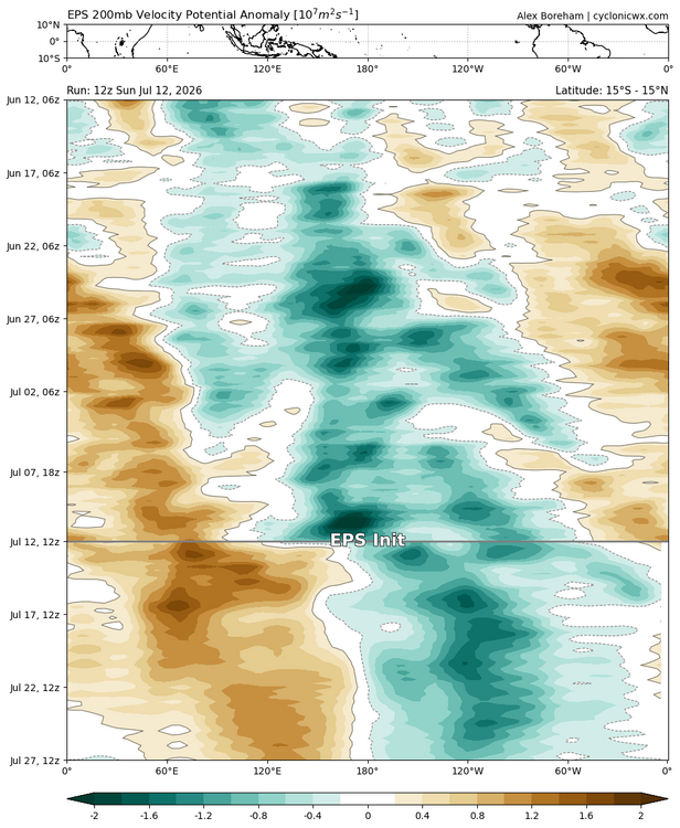
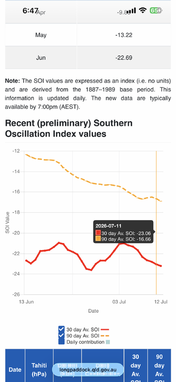
Yes. Every indicator points to it. I’m not really too concerned with a summertime 500 mb dataset that has a sample size of 4. Much of the cool summer Ninos were derived from -NAO which is less correlated.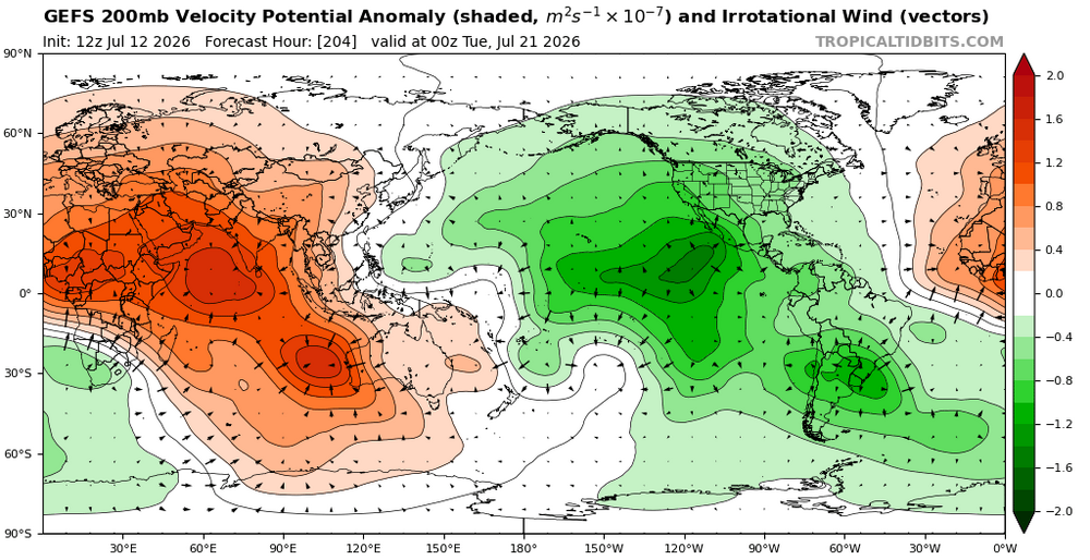
-
Frog strangler deluxe underway right now with some mild thunder. Just enough to make my jumpy dog nervous.
-
 All time all time there today
 -
2026-2027 Super El Nino
Stormchaserchuck1 replied to Stormchaserchuck1's topic in Weather Forecasting and Discussion
June was AAO's 6th most extreme month on record, since 1979. 6/570. +2.506 - Today
-
2026-2027 Super El Nino
Stormchaserchuck1 replied to Stormchaserchuck1's topic in Weather Forecasting and Discussion
You really think this is fully coupled? This is typically a La Nina pattern -
 hmmm I don't think so. they look like a super tiny worm. They're literally like the width of a finger nail. If I tired to take a pic of some, they're so small the camera can't focus to capture it lol
 -

Mountain West Discussion
mayjawintastawm replied to mayjawintastawm's topic in Central/Western States
I could tell it was super-warm up high, because with a dewpoint of 50 and a temp of 95 (which it was at my house) there weren't even any clouds. Not even the slightest hint of convection. Ugh. -

Central PA Summer 2026 Discussion/Obs Thread
mahantango#1 replied to Voyager's topic in Upstate New York/Pennsylvania
Just heard some today. -
Temps peaking right now at 92/71/98. General low/mid 90's around here with 80's along the shoreline. Still only 79 in the house, so doing good. Will open the windows later after sunset.
-
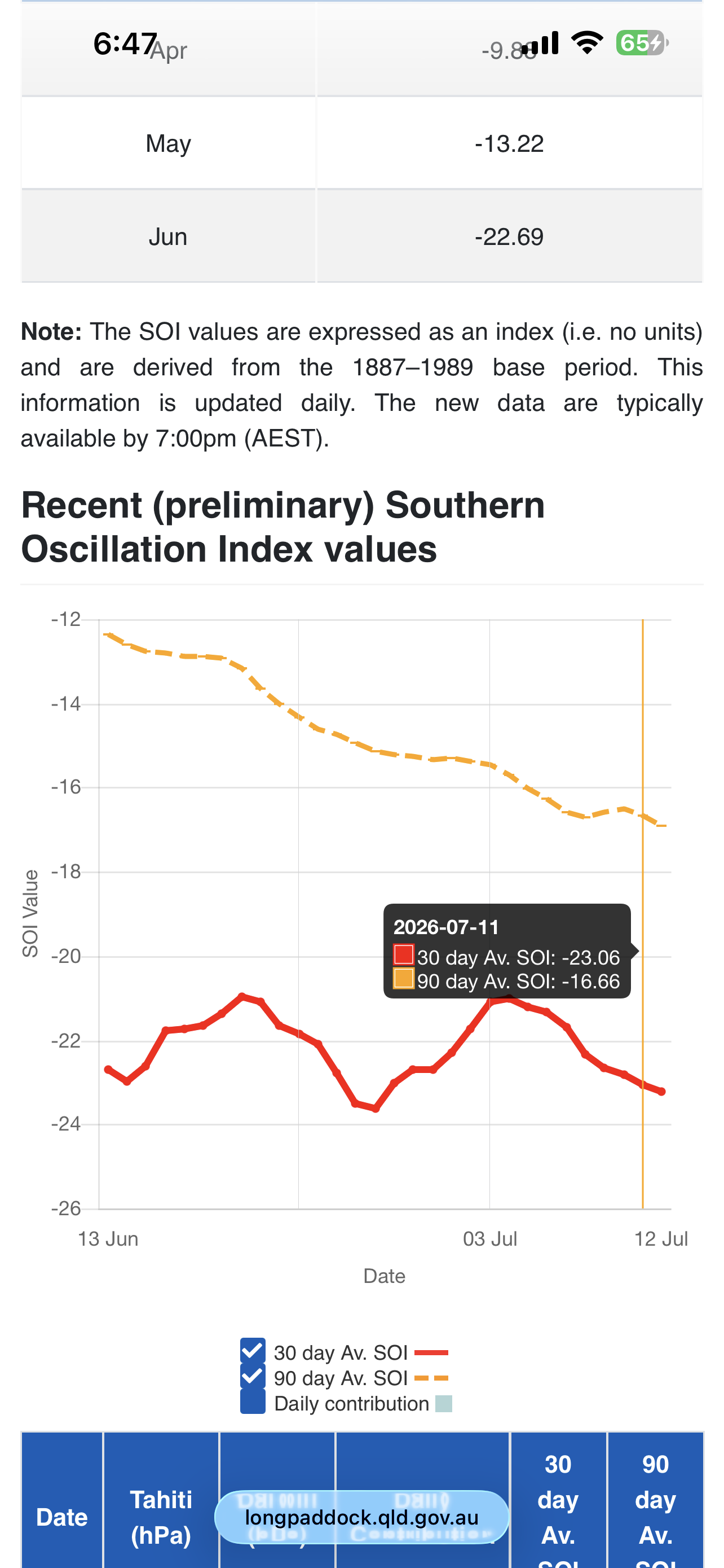
Temperatures will peak in the lower to middle 80s tomorrow before heat begins to push in from the Plains States. A brief push of heat from an impressive heat dome over the Central and Northern Plains that sent the mercury to all-time records of 109° at Salt Lake City and 110° at Billings, MT could send temperatures into the 90s during Tuesday through Thursday. The potential exists for Newark to approach 100° at the height of the short period of heat. Friday will also be very warm before the temperatures ease for the weekend. The ENSO Region 1+2 anomaly was +3.4°C and the Region 3.4 anomaly was +1.8°C for the week centered around July 1. For the past six weeks, the ENSO Region 1+2 anomaly has averaged +2.80°C and the ENSO Region 3.4 anomaly has averaged +1.52°C. The ongoing strong El Niño will continue to strengthen through the summer. The SOI was -38.53 today. The preliminary Arctic Oscillation (AO) was -0.478 today. Based on sensitivity analysis applied to the latest guidance, there is an implied near 63% probability that New York City will have a warmer than normal July (1991-2020 normal). July will likely finish with a mean temperature near 78.7° (1.2° above normal). Supplemental Information: The projected mean would be 2.2° above the 1981-2010 normal monthly value.
-
.thumb.jpg.6a4895b2a43f87359e4e7d04a6fa0d14.jpg)
Central PA Summer 2026 Discussion/Obs Thread
Yardstickgozinya replied to Voyager's topic in Upstate New York/Pennsylvania
Has anyone heard any annual cicadas yet his year ? Last year was a very weak year for them in my area, and this year doesn't seem like it'll fare any better. I thought the rain would help some emerge, but still nothing. -

Winter 2026-2027 Seasonal Outlook
Upstate Tiger replied to WinstonSalemArlington's topic in Southeastern States
From Glenn Burns. I know it is the middle of summer, however there are some clear signals already being seen about our upcoming winter. Early signs are emerging for more Polar Vortex disruptions. New long-range data shows a notable January weakening signal in the stratosphere. We have a Super El Nino changing global wind and weather patterns. Another MAJOR contributor is the melting arctic sea ice. The arctic is warming 4 times faster than the rest of the planet! Just look at the difference in sea ice from just 10 years ago. A 40% loss! With more exposed ocean we have more heat being absorbed. That heat is a major contributor to disruptions and weakening of the polar vortex, sending frigid arctic air south. With a Super El Nino providing a lot of moisture in the southeast, things could get very interesting this winter, especially late winter. A weaker or disrupted Polar Vortex does not guarantee cold and snow for everyone. But it does increase the chance that Arctic air can break out of the polar regions and reach us. Looking at the past three "Super" El Niño events—1982–1983, 1997–1998, and 2015–2016—the overarching theme for North Georgia was abundant moisture and a supercharged southern storm track. Because a strong El Niño parks the subtropical jet stream directly over the Southeast, a steady conveyor belt of Gulf moisture is virtually guaranteed. However, the temperature profiles and wintry outcomes varied drastically based on whether cold Arctic air was available to interact with that moisture. Here is how those three distinct winters played out across North Georgia: 1982–1983: The Frozen and Wet Super El Niño This event brought the classic combination of heavy precipitation and enough cold air to deliver significant winter weather. The Setup: The active southern storm track consistently collided with suppressed, cold air masses. The Weather: It was a chilly, highly active winter. Instead of just plain rain, North Georgia saw multiple wintry mix setups. Notable Outcomes: Atlanta recorded an impressive 10.3 inches of snow over the course of the 1982–1983 season. The active jet stream also spawned a severe coastal-tracking storm system in February 1983 that dumped massive snow further up the East Coast after clearing the Southeast. 1997–1998: The Warm, Soggier "Godzilla" El Niño The 1997–1998 event was one of the strongest ocean-warming anomalies on record, but a distinct lack of Arctic air kept North Georgia mostly out of the snow zones. The Setup: While the subtropical jet stream was incredibly intense and brought storm after storm, the polar jet stayed far to the north, locking the true winter cold up in Canada. The Weather: It was a cloudy, exceptionally wet, and generally mild winter. December saw near-normal temperatures, but January and February turned remarkably warm. Notable Outcomes: Instead of snow, this winter was defined by endless rain, mud, low solar days, and localized flooding. Wintry precipitation was remarkably rare across the region despite the endless moisture. 2015–2016: The Record-Breaking Warm and Flooded Winter This most recent Super El Niño shared many traits with 1997–1998, pushing the warm and wet side of the spectrum to historic extremes, particularly early in the season. The Setup: A dominant high-pressure ridge and a strong polar vortex kept cold air bottled up north, while a moisture-rich southerly flow relentlessly pumped air from the Gulf of Mexico. The Weather: December 2015 shattered records as the warmest and wettest on record for almost all of Georgia. Atlanta averaged a staggering 12.3°F above normal for the month, with high temperatures frequently climbing into the 70s. Notable Outcomes: Atlanta recorded 12.51 inches of rain in December alone (more than 8.5 inches above normal), leading to widespread river flooding and soggy soils. January and February finally cooled down closer to long-term averages, but the winter as a whole remained overwhelmingly warm, wet, and liquid. If you look at the baseline of a Super El Niño for North Georgia, you can safely bet on well above-average precipitation and active storm tracks. But as these three events show, the difference between a historic 10-inch snow season and a winter where people are wearing shorts on Christmas boils entirely to the wild card of the northern polar jet. That is why these early signals along the melting arctic sea ice gives us a better handle on what we might expect -
 Chigger?
 -
Average high in Miles city is 90 though.. didn't realize that but still
-
2026-2027 Super El Nino
LakePaste25 replied to Stormchaserchuck1's topic in Weather Forecasting and Discussion
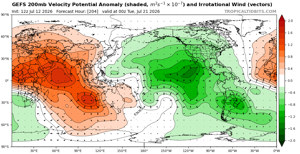
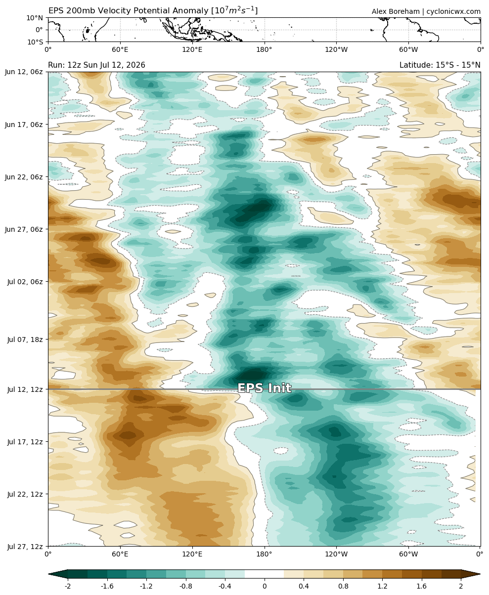
July should be our first “fully coupled” month. Come August, will need to find a site that plots omega since NCAR is discontinued. Would like to compare it to past super nino July’s. -
It's 115 in Miles City Montana right now.. that's nuts!