All Activity
- Past hour
-
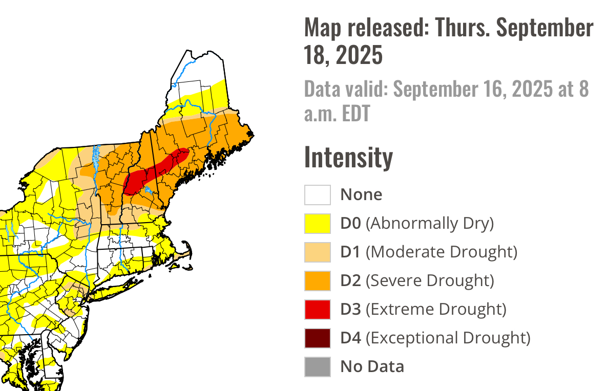
Surprised the orange zone didn’t expand much.
-
The red dong of d3 expands

-
0.26" fell late yesterday afternoon in a 30 minute shower, pushing this year into third (behind 1985's 0.06" and 2019's 0.27") with 0.37" now for the month. I doubt it stays there with 12 more reporting days, but we shall see. Amazing what a bit of rain does, grass is greener this am and the trees that have turned (about 25% are in color) look awesome.
-
What in tarnation is going on up here

-

2025-2026 ENSO
PhiEaglesfan712 replied to 40/70 Benchmark's topic in Weather Forecasting and Discussion
I'm hoping it stays ENSO neutral. That's probably our best chance for a decent winter. A la nina and deep -IOD combination almost certainly means a blowtorch winter and very low snow totals. -
I fully expect his annual windshield frost post.
-
ENSO isn't truly neutral ... it's more like quasi negative, fw little iw ... biased < 3.4. The problem is the surrounding atmosphere is so expanded beyond, there's no geophysical triggers to force a pattern evolution. It's like a chick moving around inside an eggshell - the outside world doesn't know that is happening. That won't ( likely...) characterize the winter ahead, of course. But for the time being, the intraseasonal variance may see wondering into a quasi positive or negative ( probably favoring the latter this time...), and it won't mean a darn thing to the hemisphere. Not until the seasonal compression of the hemisphere quickens the geopotential height medium --> increasing basal winds, and that's when the planetary wave tendencies/feedbacks are forced/exposed. In fact, this may transitively then feedback and force a more coherent tendency with the ENSO, one way or the other ... Anyway, that's probably ... I dunno, later October+ but more so by Thanks Giggedy. And that may not really turn out to be the winter hemisphere. Some > 50% of the time, yes, there is some vestigial usefulness in identifying - usually through - the nonlinear observations of "lurking" tendencies during those early seasonal flavors... It's your chance to be artful.. The other aspect - as I wonder into a seasonal outlook tendency I did not mean to ... - is that it's been papered by other sources that jet meanders are becoming more common, particularly during the shoulder seasons. It's why I suspect that we may observe some blocking tendencies in the AO(WPO/EPO/NAO) between the late Oct - Xmas time.. But I grow increasingly confident with each passing year that the winter hemisphere might be forever changed - it seems regardless of all leading indicator methods, we seem to wend our way into a version of: This may obliterate, however ...as the machinery of deep winter takes over with its (probable) repeat performance of > normal gradient everywhere and basal flow velocities hurried along, that disturbs resonance feedbacks and patterns have difficulties establishing... That means we may have problem locking in either cold or warm, in lieu rapid variance ( relatively...). 10 day winter pops followed by 53 F streaks kind of thing. That's also sloppy description of the last several winters, frankly, which seem to have become a leitmotif.
-
0.00” Min 48.7°
-
I've had frost at 37° plenty of times. You can, too. Believe!
-

September 2025 OBS-Discussion centered NYC subforum
bluewave replied to wdrag's topic in New York City Metro
The 1980s snowfall averaged about 6” higher than the last 7 seasons. Monthly Total Snowfall for JFK INTERNATIONAL AIRPORT, NY Click column heading to sort ascending, click again to sort descending. Mean T 0.1 2.6 8.2 5.9 2.7 1.0 20.4 1979-1980 T 0.0 2.5 3.0 2.3 3.2 T 11.0 1980-1981 0.0 0.2 1.7 7.7 T 6.9 0.0 16.5 1981-1982 0.0 T 3.1 12.5 0.8 0.3 8.2 24.9 1982-1983 0.0 0.0 4.8 1.0 24.7 0.1 1.5 32.1 1983-1984 0.0 T 1.2 9.9 T 10.9 T 22.0 1984-1985 0.0 T 5.5 12.4 9.0 0.4 T 27.3 1985-1986 0.0 T 2.8 3.0 13.5 T T 19.3 1986-1987 0.0 0.4 1.0 11.8 7.9 2.0 0.0 23.1 1987-1988 0.0 0.4 3.0 15.7 0.5 0.1 0.0 19.7 1988-1989 0.0 0.0 0.7 4.7 0.1 2.7 0.0 8.2 Monthly Total Snowfall for JFK INTERNATIONAL AIRPORT, NY Click column heading to sort ascending, click again to sort descending. Mean 0.0 0.7 1.8 3.7 7.3 1.0 T 14.5 2024-2025 0.0 0.0 3.0 2.5 6.5 0.0 0.0 12.0 2023-2024 0.0 T T 2.4 10.4 T 0.0 12.8 2022-2023 0.0 T T T 1.7 0.4 0.0 2.1 2021-2022 0.0 T 0.2 17.8 3.2 0.5 0.0 21.7 2020-2021 0.0 0.0 7.2 0.9 26.4 T T 34.5 2019-2020 0.0 T 1.9 1.9 T T T 3.8 2018-2019 0.0 4.8 T 0.7 3.1 6.1 0.0 14.7 -
Is there a way to actually do that? I've always just done it the hard way, but ultimately gave up when the thread's hundos pages deep...
-
CoC n Stein.
-
1.25” here and about 2.40” for September. Glad some of the drier areas got the goods.
-
Back to Summer until at least early October. Yuck.
-
1.23" here in the lowlands. That was the classic "lowland bullseye" when everyone nw freaks out while I laugh because we all know they'll jackpot anyways lol. I'm really happy to see the dryer areas max potential. It definitely wasn't needed here. My hiking trails have been muddy since the end of June.
-

E PA/NJ/DE Autumn 2025 Obs/Discussion
JTA66 replied to PhiEaglesfan712's topic in Philadelphia Region
That 18-wheeler hit three potholes by my count. Finished with .15" yesterday bringing my monthly total to 1.90". 61F - Today
-
2.55 inches for total event here in Purcellville.
-

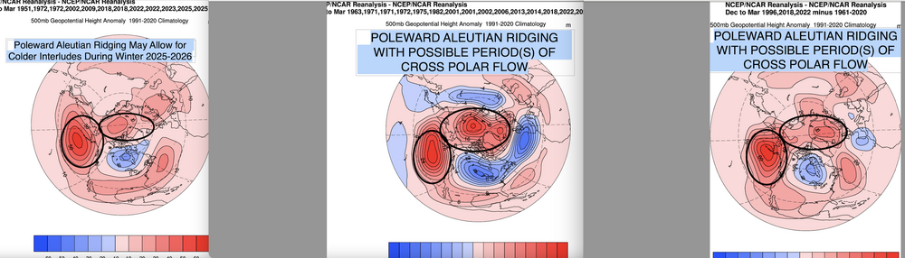
2025-2026 ENSO
40/70 Benchmark replied to 40/70 Benchmark's topic in Weather Forecasting and Discussion
Nice consensus emerging-
-
.55 but just missed out on some heavier stuff. Should buy my overseeded lawn a couple of days
-
2025-2026 ENSO
40/70 Benchmark replied to 40/70 Benchmark's topic in Weather Forecasting and Discussion
I agree completely with this...with the added caveat that I could see a northern stream KU that wouldn't do much for the mid atl. -
0.41
-
Still raining here. It can end now please.
-
52 degrees not a drop of rain this week.
-
2025-2026 ENSO
40/70 Benchmark replied to 40/70 Benchmark's topic in Weather Forecasting and Discussion
Hey, I'm north of Boston and have become a winter voyeur myself -

September 2025 OBS-Discussion centered NYC subforum
MANDA replied to wdrag's topic in New York City Metro
Had additional showers last evening that helped get the total up to .19". I'll take it as another 7 day stretch of dry weather is ahead.
.thumb.png.4150b06c63a21f61052e47a612bf1818.png)