All Activity
- Past hour
-

July 2025 Obs/Disco ... possible historic month for heat
powderfreak replied to Typhoon Tip's topic in New England
You just listed the last three summers for ORE… they are all like top 5-10 heaters. I dunno, I applaud you guys for the fight. I gave in a couple summers ago. -

July 2025 Obs/Disco ... possible historic month for heat
WxWatcher007 replied to Typhoon Tip's topic in New England
Rampant drunkenness in here today lol. Mod excessive rainfall risk extended into SW CT -

July 2025 Obs/Disco ... possible historic month for heat
CoastalWx replied to Typhoon Tip's topic in New England
@dendrite BHO is using the instrumentation at the top of the hill correct? I see Blue Hill COOP in the Nowdata. I ask because I see 96 and 95 there for the last two days. Scratching my head a bit at those values, but I suppose it could be right. -

Central PA Summer 2025
Mount Joy Snowman replied to Voyager's topic in Upstate New York/Pennsylvania
Haha I know wasn't it just lovely out!? Seriously though, my P&C even as recently as Tuesday morning had me at 97 for both Tuesday and Wednesday, whereas MDT and LNS topped out at 93/94 and 94/95 for those days, respectively. Heck, even CXY went only 94/93; THV only 91/92. As @Jns2183 mentioned, high Dews are the enemy of high temps, but the forecasts should certainly be factoring in all of that. Not a huge bust or anything, just thought it was notable. Heat indices were unbearable either way ha. -

July 2025 Discussion-OBS - seasonable summer variability
SACRUS replied to wdrag's topic in New York City Metro
1000AM Roundup JFK: 87 ISP: 86 New Brnswck: 85 TEB: 85 EWR: 85 NYC: 83 LGA: 81 -
Was checking the cfs and euro monthlies, and both show hints of AK ridging (-epo) which would lead to a winter like last season. With the QBO going negative, it might not be a bad thing. We'll see if this holds because otherwise without that AK ridging given all other factors, we may not have much of a winter to look forward to. So far there's a hint of optimism.
-
Every single time I've been missed the past couple of weeks I immediately think of that post that you made.
-

July 2025 Obs/Disco ... possible historic month for heat
dendrite replied to Typhoon Tip's topic in New England
BOS -

July 2025 Obs/Disco ... possible historic month for heat
HoarfrostHubb replied to Typhoon Tip's topic in New England
Not trying to be a smartass, just generally curious… which sites have 150 years of data… I assume BHO…CON? -
July 2025 Obs/Disco ... possible historic month for heat
CoastalWx replied to Typhoon Tip's topic in New England
Will be a wet month here thanks to 7/10. Might get to 10-11” -
That is nuts. Whoever gets in the deluge will be suffering some serious flooding.
-
July 2025 Obs/Disco ... possible historic month for heat
CoastalWx replied to Typhoon Tip's topic in New England
ACATT gone wild. -
July 2025 Obs/Disco ... possible historic month for heat
dendrite replied to Typhoon Tip's topic in New England
Tell them you’ve already had plenty of novocaine this morning -
July 2025 Obs/Disco ... possible historic month for heat
dendrite replied to Typhoon Tip's topic in New England
We’re comparing a LR forecast to simple addition? -
 It is very dry here right now, so I'm hoping for some heavy rain. I'll take the 1 to 2 inches that this HRRR run shows for our area, but of course we don't want the huge flooding amounts that this run shows for Monmouth County. Obviously it's difficult for the model to pinpoint exactly where those jackpot amounts will occur. The next run will probably look different. Who knows.
 -
Area Forecast Discussion National Weather Service Baltimore MD/Washington DC 939 AM EDT Thu Jul 31 2025 .SYNOPSIS... A cold front will slowly move across the mid-Atlantic today through Friday. Strong high pressure will build into the area over the weekend, bringing below normal temperatures and humidity. High pressure weakens into next week while the next front is expected to slowly approaches from the south. Rain chances return by the middle of next week. && .NEAR TERM /THROUGH FRIDAY/... Excessively humid conditions are being observed across the region with dew points well into the 70s to near 80 and PW in excess of 2 inches (even 70+ Tds over the higher terrain). This will fuel thunderstorms with very heavy rain beginning in a few hours (roughly midday onward). A cold front will sag south into our region today. A strong shortwave trough will move over our area this afternoon and evening. A persistent southerly flow will provide deep tropical moisture to help fuel numerous heavy showers and strong to severe thunderstorms this afternoon and evening. Dewpoint temperatures in the low to mid 70s will result in revealing PWATs of 2.2 to 2.3 inches. One final day of hot and humid conditions today with the developing convection. Highs are forecast to be in the upper 80s to low 90s, with peak heat indices between 95-105.
-
I've been personally looking for a Bahama Blue circulation mode to set up... It's when you get a deep layer cross-latitudinal flow straight along and off the EC ... S to N with mass gathering from the eastern Gulf meshing in with Trade circulation fields turning NW through the Bahamas and all the way up the stream comes. It's actually some of my most fascinating weather...just knowing the the deep blue with brilliant narrow turreted CU towers and their blinding single pixel rain shafts are bring the tropics to a none tropical climate. heh. Anyway, I have seen some hints of that in recent guidance but not convincing.
-

July 2025 Discussion-OBS - seasonable summer variability
winterwarlock replied to wdrag's topic in New York City Metro
Looks like 90 plus possible today -
It's 84 with dewpoint of 79 Sent from my SM-G970U1 using Tapatalk
-
I feel nuts sitting here worrying about rain when everyone else seems to be +7"-12" on me for the year Sent from my SM-G970U1 using Tapatalk
-
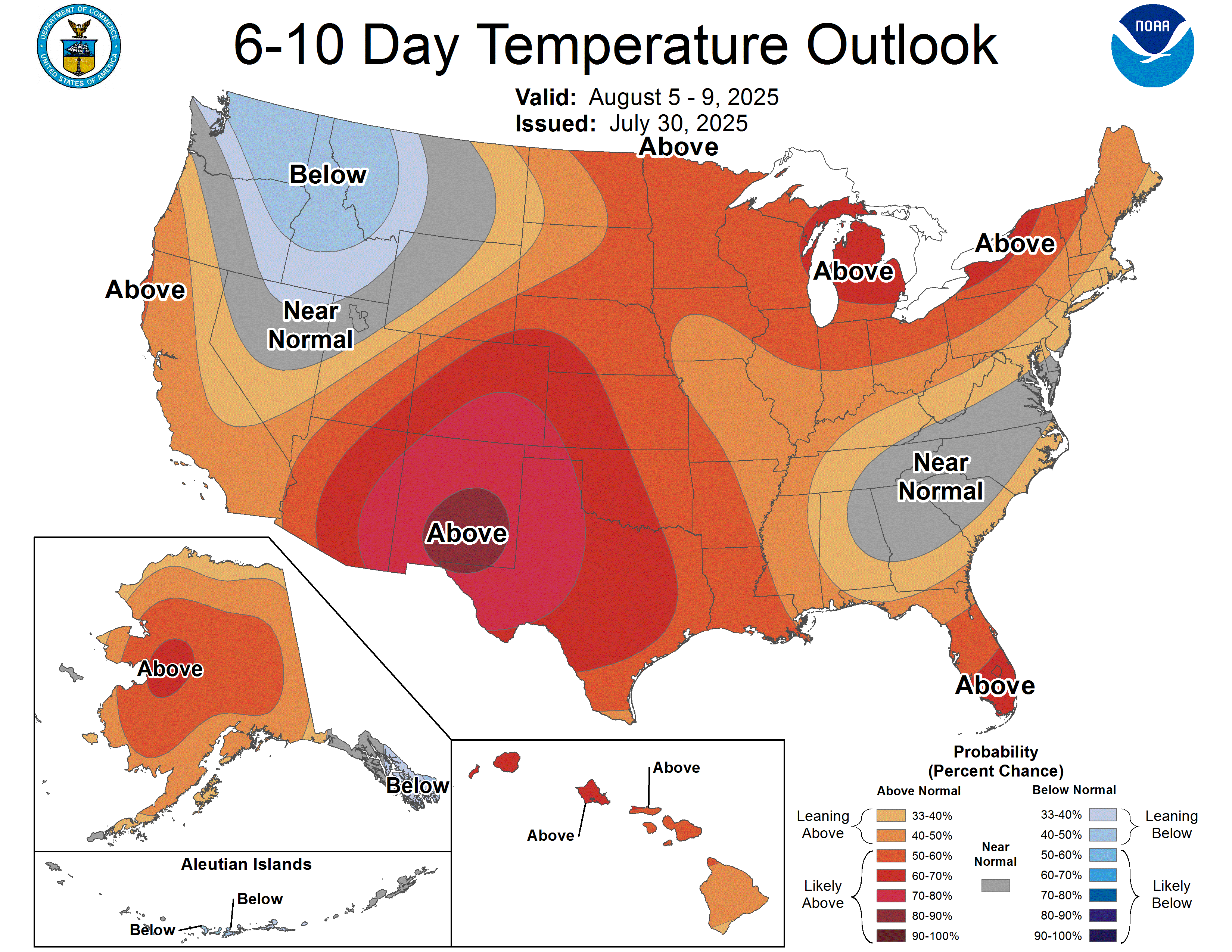
Beyond this weekend .. what we got? The CPC's enhanced probability for above normal temperatures. Just a primer (again..) on how to use this product: the intensity of red colorization does not mean higher scalar temperature. Orange hues progressing to red means greater and greater probability of above normal temperature in that order. In other words, this product says nothing of the magnitude of above normal. If the days turned out +0.01 ..this product was successful. Very high probability of above normal with that deep insidious dried scab over NM for example, means that there is a very high probability, based upon whatever methods CPC uses to assess, that the time range will average between 0 and Nth degrees above normal. This all conceptually true at the other side for BN, obviously. Having said all that, yeah...there some semblance of trend in the operational longer range means to roll another warm interlude out of the west. That observation matches timing with the day 8-14 from the same source above. The teleconnector numerical fields are positive-nominal ( AN but not +AN). SO ....there's likeliness for AN from all this blended info but nothing that smacks as exceptional at this time. It's important and obvious to note that telecons and these spatial synoptic layouts, et al, are more stochastic in summer, which doesn't lend to predictive skill.

-

July 2025 Obs/Disco ... possible historic month for heat
kdxken replied to Typhoon Tip's topic in New England
Don't know where you went to school but in mine if the teacher asked what's 6 + 6 and you answered 5 you would be wrong. -
July 2025 Obs/Disco ... possible historic month for heat
HoarfrostHubb replied to Typhoon Tip's topic in New England
Above normal as far as temps go. Less precip than normal. More humid than normal. -
I said it the other week when we were chattin up big totals for 2025, that we'd probably jinx it and rest of year struggle to reach climo. While i dont think that'll happen.....just like AI....mo nature listens to everything we say.
-
July 2025 Obs/Disco ... possible historic month for heat
dendrite replied to Typhoon Tip's topic in New England
ACATT off the rails