All Activity
- Past hour
-
60 18z NAM
-
FYI, when you do analysis of a model run, everyone assumes you are comparing it to its previous run. If you are comparing it to a different model you have to say that or no one will know what you're talking about...even more than normal.
-
Heights still a little lower than 12z Nam at 57hrs
-

Winter 2025-26 Short Range Discussion
A-L-E-K replied to SchaumburgStormer's topic in Lakes/Ohio Valley
what u got otg? radar looks good for a DAB later here unless virga again -

January 24-26: Miracle or Mirage Thread 2
Stormchaserchuck1 replied to mappy's topic in Mid Atlantic
Almost a negative tilt over AZ on the NAM at 60hr lol -
NAM should be better. More seperation with the streams at 5H out to 60
-
not that it matters much, but the 18z NAM out to 54 looks like it would end up being less conducive to an earlier phase less interaction between our southern energy and the stuff diving out of Saskatchewan, noticeably lower heights out east as the ULL over SE Canada is a little later to depart
-
heavy precip is over there...they go to mix during the light precip that lingers after the WAA thump...the dryslot stuff. DC doesn't actually lose much QPF to mix on this EC run...it was close...but they held the thermals through the crazy heavy precip then warmed immediately after...which is common.
-
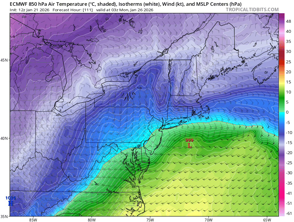
 look at this map it shows 850's below freezing that shows snow all around south of long island and nyc could be sleet but nyc and north is all snow on the euro. its a great run!
-
They are terrible! Fixed it for you!
-
It’s looking less than 12z Nam so far so we will see
-
If 18Z Nam were to continue to progress like this the dome above any baja energy would almost surely have to force the precip to undercut. It was trending nicely up until around the 54 hr mark on 12Z and then heights rose pretty dramatically so we'll see if we lose again.
-

January 24-26: Miracle or Mirage JV/Banter Thread!
clskinsfan replied to SnowenOutThere's topic in Mid Atlantic
No. I might literally cry for the first time 40 years. -
I’m not hating the NAM so far. Likely won’t be enough but it’s looking better
-
https://freeimage.host/i/frivKN4 - This is 12z
-
.
-

January 24-26: Miracle or Mirage JV/Banter Thread!
pazzo83 replied to SnowenOutThere's topic in Mid Atlantic
I love Chicago, but with the air mass modeled next week, I think I'd have to pass lol. -
January 24-26: Miracle or Mirage Thread 2
Stormchaserchuck1 replied to mappy's topic in Mid Atlantic
I'm comparing to the 12z GFS. SW piece isn't cutoff on the NAM at hr57 -
 I wouldn't call that very likely. Very likely you changed to sleet at some point I give better odds of that. Probability of over a foot in central Suffolk? 22.7%
 -
 That would be a fair criticism if he was telling us what he thought was most likely to happen. But that's not what he posted about...he posted about the possibility of how the storm could underperform...so it makes sense that he'd cite the models that give us reason for concern.
 -
Yea we won't see those 18-1 crazy ratios...BUT...QPF tends to overperform in those crazy WAA driven thumps so it actually tends to be a wash (in terms of snowfall performance compared to modeled QPF. In one case we overperform due to rations in the other because of QPF.
-

Winter 2025-26 Short Range Discussion
hawkeye_wx replied to SchaumburgStormer's topic in Lakes/Ohio Valley
Wind is gusting to 60-70 mph in wc IA and ec NE. DVN has issued a blizzard warning for my area. I'm not sure we'll get enough snow to justify that. -

January 25/26 Jimbo Back Surgery Storm
SouthboundYank replied to Jimbo!'s topic in Southeastern States
Thought my Midland weather radio was crapping out on me today, but no....we're just not getting signal here in northeastern SC. That seems quite problematic to me, given that we're 3-4 days out from a major (some would say "historic") winter storm...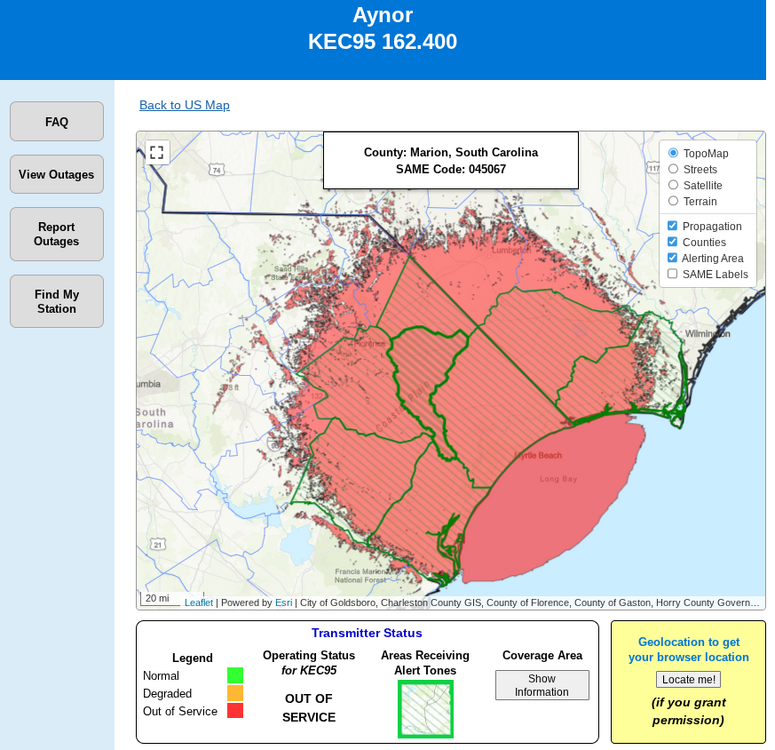
-
Your analysis is way different than others saying it’s not as phased lol
-

Possible Record Breaking Cold + Snow Sunday 1/25 - Tuesday 1/27
Rjay replied to TriPol's topic in New York City Metro
It seems like an ok bet right now but it's still too far out to give numbers. The odds of a 6+ plus storm are relatively high subforum wide.