All Activity
- Past hour
-
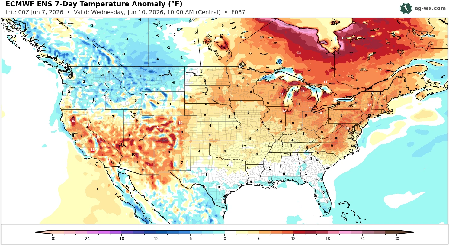
NAM tries to bring a few storms across our region this afternoon. Looks like slim pickings but it's a chance.
-
A busy hazards week across the country
-
74F/ gusty, pollen everywhere......
-

Central PA Summer 2026 Discussion/Obs Thread
mahantango#1 replied to Voyager's topic in Upstate New York/Pennsylvania
-
Another round of 90 degree days on the way later this week - does anyone have stats on the record number of 90 degree days anywhere in the metro prior to the official first day of summer for a given year ?
-
pretty wild storm while camping at Nickerson St Park last night.
-
The sparking lines/transformers and smoke emanating from the grid across several blocks in Maspeth, Queens, during yesterdays severe weather. Through the night we had distress calls to 911 from downed lines, and/or those catching fire. The hazard can be seen toward the end of the clip looking north/west. Popping can be heard and smoke is evident in the last seconds before ending recording to call 911. FDNY later responded. I corrected the camera orientation in the second clip after several seconds. EDIT: I have wind chimes heard through the recording.
-
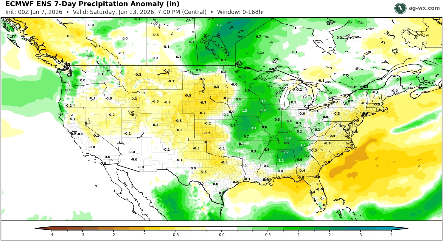
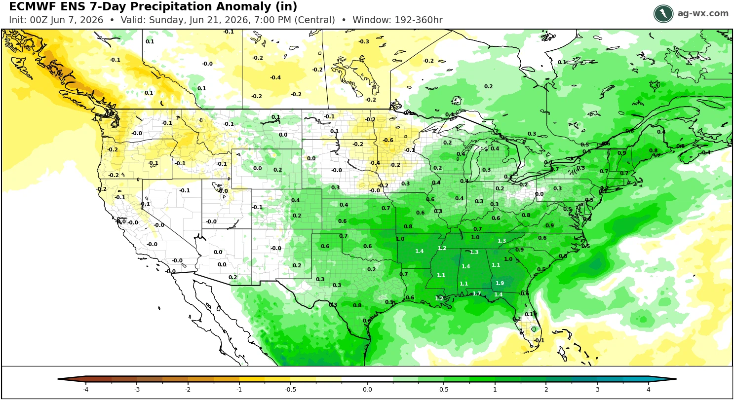
Similar recent theme of the wind gusts being more impressive than the actual rainfall amounts. Another very warm with below average rainfall pattern coming up this week. Hopefully, the models are correct about the wetter pattern with the Great Lakes trough during week 2 approaching the summer solstice.


- Today
-
This ended up knocking out our power for 3 to 4 hours last evening. We got about 3/4 inch of welcomed rain and constant thunder for about 45 minutes. It passed just to our north so nothing too strong. Some good gusts.
-
Yeah there was another downpour here around midnight. Ended up with 0.15" for the day. Was expecting nothing ofc.
-
Quick clap of thunder and downpour after midnight last night.
-
Got lucky enough to get alittle over 1/2”….enough to not have to water the plants today i guess. Wind was impressive tho, branches down everywhere.
-
Something came through patio chairs down. Didn't wake me.
-
If anyone is looking to move to southern MD (or knows someone who is), send me a PM. Our previous home in Prince Frederick is still for sale… it’s been a much slower market down there than anyone expected (including our realtor).
-
.28 yesterday with some gusty winds as it came through, lots of small branch's and leaves down in my yard. A number of trees down close by though. The power flickered but didn't go out thankfully.
-
0.02” yesterday separated between two 0.01” showers.
-
0.21” here. One rumble of thunder
-
As expected. Never had a chance here. Probably didn’t even rain. Doubt we get anything today. Stein is here. Can put lawn mower away.
-
I can't believe a couple showers actually made it into the dried up lowlands during the night. It looks like it didn't amount to much but it's something.
-

2026 Atlantic Hurricane Season
WxWatcher007 replied to Stormchaserchuck1's topic in Tropical Headquarters
The signal looks real with a CAG looking to develop and the EPAC starting to light up, but the AI ensembles not being as robust still gives me pause. Either way, another interesting aspect here is the models all showing the potential for tropical moisture to get carried into at least the southeastern U.S. as a ridge flexes in the western Atlantic and a trough tries to sweep eastward from the central U.S., creating a near ideal conveyor belt for moisture transport. That’s something to watch in its own right, and why I’m a little skeptical of the euro operational burying whatever seedling there is in the Bay of Campeche. -

2026-2027 Super El Nino
GaWx replied to Stormchaserchuck1's topic in Weather Forecasting and Discussion
It sometimes updates later but, yes, it often does update in the middle of the night our time. The 24 hour period that each daily is based on evidently ends at about the average middays of Darwin and Tahiti. -

2026-2027 Super El Nino
Stormchaserchuck1 replied to Stormchaserchuck1's topic in Weather Forecasting and Discussion
^It updates at 2am? -
2026-2027 Super El Nino
GaWx replied to Stormchaserchuck1's topic in Weather Forecasting and Discussion
It turns out that the models were right on as today’s Darwin SLP is 1017.70, the earliest that high so early in the season and the 6th highest on record: 7 Jun 2026 1014.05 1017.70 -34.73 Darwin will be lower tomorrow. Based on history, that 1017.7 could easily end up the highest daily Darwin SLP of 2026. But there’s no telling for sure as an SLP that high remains possible through September. -
Thanks. If a Gulf TC were to materialize in mid June, then JB will get a big win on a call he made way back in late April as I recall based on projecting MJO phase 8 in early or mid June though he had been leaning more toward a week earlier as he even admitted.
-
2026-2027 Super El Nino
GaWx replied to Stormchaserchuck1's topic in Weather Forecasting and Discussion
Thanks, Chuck. Consistent with that, 2025 has by a large margin the strongest +AO for the period I was analyzing, May 23rd-June 4th from 1958 through 2026. That period in 2025 was chilly (~1.5C BN) though not nearly as cold as the ~-3.5C of 2026. By the way, 2026 had the 4th strongest +AO of this period back to 1958 thus intuitively helping it be one of the coldest. 2023 had the 10th strongest +AO and was ~1C BN. 1994 had the 2nd strongest +AO but it was only ~0.5C BN. 1996 had the 3rd strongest +AO, but it was NN rather than cold. So, the correlation of +AO to cold N of 80B is far from perfect due to other factors coming into play as you very likely realize even though there’s still a decent partial correlation.